Miami-Dade County Map visitors usually need to answer several different questions at once: where Miami sits in relation to Miami Beach, how far the developed metropolitan area extends west, where Homestead lies in South Dade, and how Biscayne Bay, canals, wetlands, and the southern sounds shape the county. This page explains those relationships with the county, city, and water maps supplied in the package. A ZIP containing the three high-resolution A3 JPG map files is available for download in the map file box below.
Miami-Dade is especially useful to study as a whole county because its geography changes sharply from east to west. The Atlantic-facing side contains a dense chain of cities and highways, while the western half becomes much more lightly labeled and water-dominated. South Dade adds another pattern: Homestead and Florida City form a separate southern center before U.S. 1 continues toward Monroe County and the Florida Keys.
Table of Contents
A Narrow Metropolitan Strip Beside a Much Larger Wetland West
The county map makes the east-west contrast immediately visible. Miami occupies the mainland side of Biscayne Bay, with Hialeah, Miami Lakes, Miami Gardens, Medley, and Doral spread across the northern and western parts of the metropolitan area. Coral Gables, Pinecrest, Palmetto Bay, and Cutler Bay continue the developed strip southward. These places occupy only a relatively narrow part of the county even though they contain most of the map’s named communities and major roads.
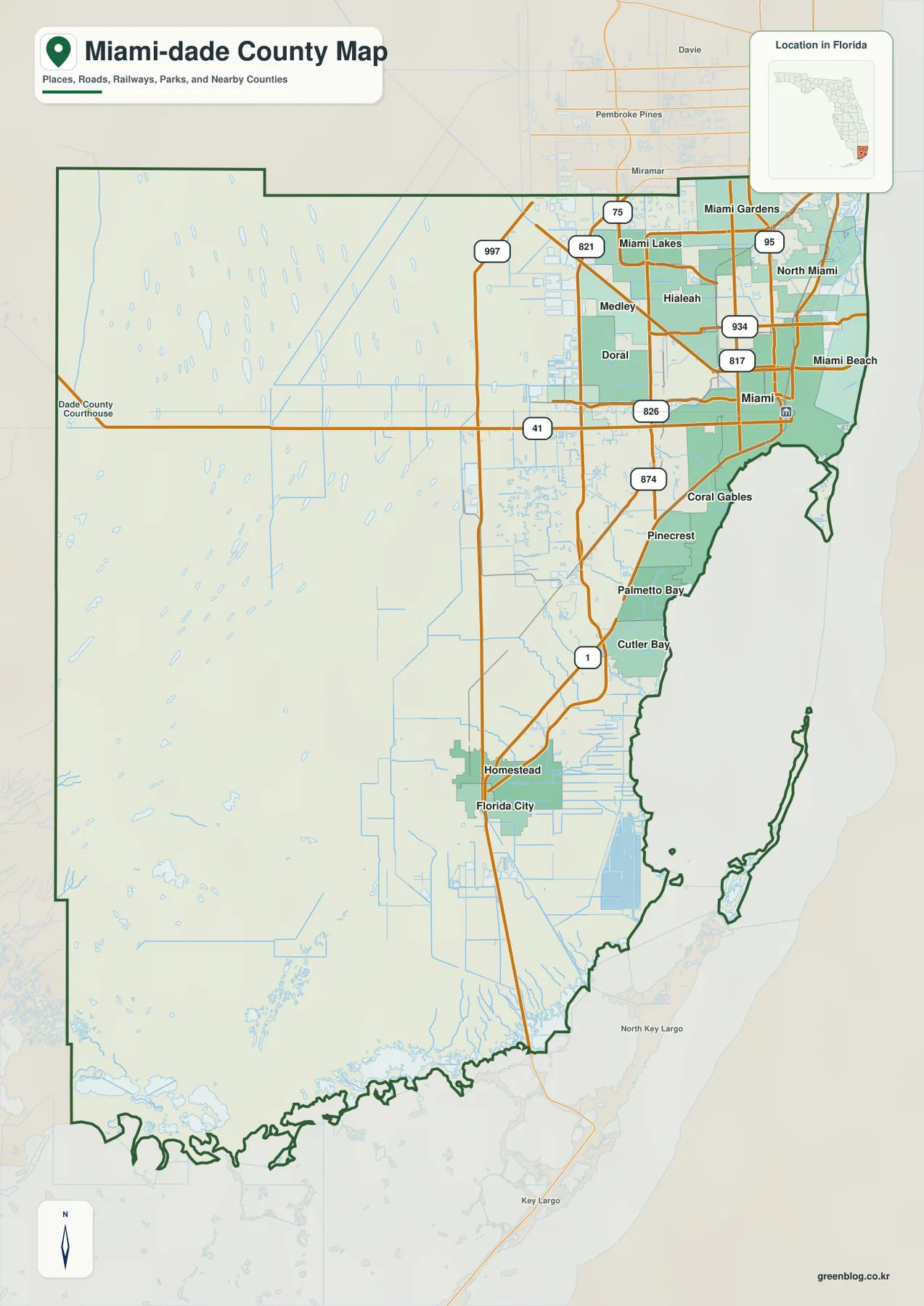
West of the built-up corridor, the visual character changes quickly. Large road networks disappear, named cities become scarce, and numerous small water features appear within a broad open area. The source material supplied with this rewrite identifies the Everglades, conservation lands, and water-management areas as major reasons for this pattern. The light labeling in western Miami-Dade should therefore not be read as empty land waiting for an urban grid; it represents a very different part of South Florida’s landscape and water system.
Miami, Hialeah, and the Separate South Dade Center
The city map reduces the road detail and makes the settlement pattern easier to compare. Miami is the main reference point, while Hialeah lies to the northwest and Miami Gardens is farther north near the Broward County side of the map. Doral sits inland west of Miami, and Miami Beach occupies the coastal side of Biscayne Bay rather than the mainland city itself. That distinction is important because “Miami” is often used informally for the wider metropolitan area even when a location is outside the City of Miami.
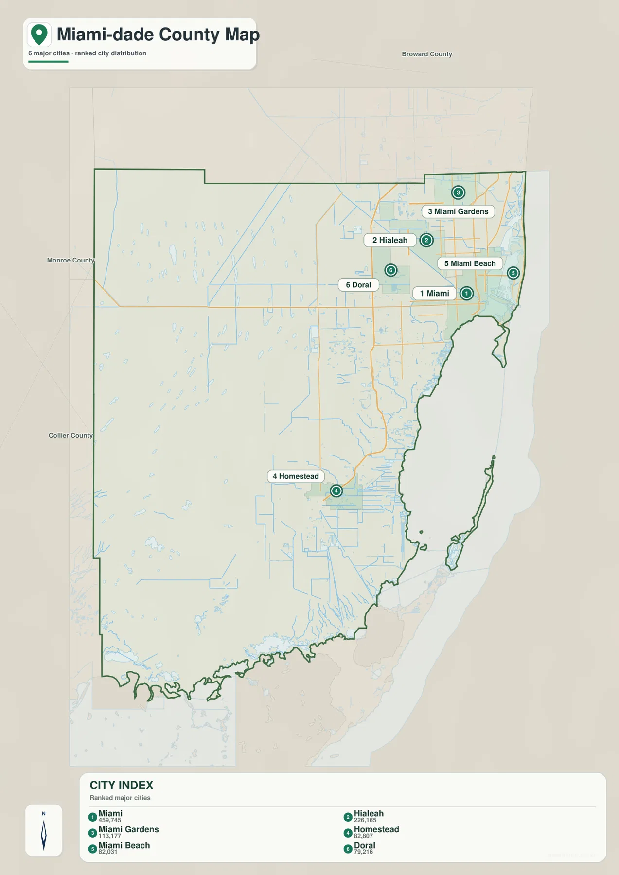
Homestead stands apart from the northeastern cluster and gives South Dade its own clear anchor. Florida City is immediately to its south on the general county map. From this area, U.S. 1 continues toward Monroe County and the Florida Keys, while roads also lead toward the Everglades side of the county. The space between the Miami urban core and Homestead is not empty, but the settlement pattern is less continuous and the road network gradually becomes simpler.
Reading U.S. 1, U.S. 41, the Turnpike, and the Western Routes
Miami-Dade’s road pattern is easiest to understand by separating the coastal corridor from the western approaches. U.S. 1 is the most intuitive north-south route for following the developed eastern and southern part of the county. It continues toward Homestead and Florida City before leaving Miami-Dade for the Florida Keys. In the northern and western metropolitan area, I-75, SR 821, and SR 826 connect communities that sit farther from Biscayne Bay and downtown Miami.
U.S. 41 crosses west from the Miami area toward the Everglades, creating one of the clearest transitions from dense development into the lightly settled western landscape. SR 997 follows the western edge of the urban and agricultural areas in a north-south direction, while routes such as SR 874 help connect the southwestern suburbs back toward the main highway system. On the county map, road spacing becomes much wider as the map moves west, which visually reinforces how strongly transportation is concentrated in the eastern half.
Biscayne Bay, Canals, Creeks, and the Southern Sounds
The water map reveals a second geography that a road map cannot show as clearly. Biscayne Bay forms the dominant coastal water body beside Miami, and the Atlantic Ocean lies beyond the coastal islands. The Miami River reaches the bay near the central city, while Black Creek is labeled farther south. Tamiami Canal extends far across the county, making the engineered canal network visible alongside the natural bays, creeks, and wetland waters.
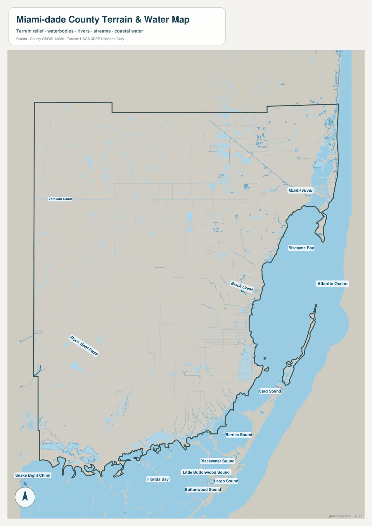
The southern shoreline is much more intricate than the urban coastline around Miami. Card Sound, Barnes Sound, Blackwater Sound, Little Buttonwood Sound, Largo Sound, Buttonwood Sound, and Florida Bay appear in sequence near the county’s southern edge. These labels help explain why the transition from mainland South Dade toward the Florida Keys is not simply a straight stretch of land. Islands, shallow water, channels, and sounds divide the coast into a complex marine landscape.
Farther west, the water map also shows scattered ponds and channels across the broad wetland interior. Rock Reef Pass and Snake Bight Channel are among the labeled water features in the south and southwest. Even without an elevation map, the concentration of water features helps visitors understand why western Miami-Dade looks so different from the road-heavy eastern side: this is a landscape where water, wetlands, and managed canals are central geographic features.
Choosing the Best Map for a Specific Question
Use the county map first when the main question involves boundaries, roads, or the relationship between Miami and South Dade. It is the best single view for locating Homestead, following U.S. 1, comparing the dense road network near Miami with the open west, and seeing how the county reaches the southern coast. The city map is faster when the task is simply to compare Miami, Hialeah, Miami Gardens, Homestead, Miami Beach, and Doral.
The water map becomes the better choice when Biscayne Bay, canals, coastal sounds, or the Everglades-side water network matters more than roads. Using all three maps together is especially helpful for Miami-Dade because city locations and water geography are tightly connected. A visitor can find Homestead on the city map, trace the route south on the county map, and then use the water map to see Card Sound and Florida Bay near the mainland-to-Keys transition.
A Few Map-Reading Details That Prevent Common Miami-Dade Confusion
First, Miami and Miami Beach are separate cities on opposite sides of Biscayne Bay. Second, the word “Miami” can describe the broader metropolitan area in everyday use, so an address or place name should not automatically be treated as part of the City of Miami. Third, Homestead is still in Miami-Dade County, but continuing south on U.S. 1 eventually crosses into Monroe County. These distinctions matter when a map is being used for trip planning, school work, local reference, or a printed county overview.
The western half also requires a different interpretation from a typical suburban county map. Fewer city names and roads do not mean that the map is missing detail. They reflect a landscape dominated by wetlands, conservation areas, canals, and water-management features. In Miami-Dade, the contrast between the eastern city corridor and western wetland interior is one of the county’s defining geographic patterns.
Frequently Asked Questions
Are Miami and Miami Beach the same city?
No. Miami is on the mainland side of Biscayne Bay, while Miami Beach is a separate city on the coastal barrier-island side. The county and city maps make that separation easy to see.
Why does western Miami-Dade have so few city labels and major roads?
Much of the west is associated with Everglades wetlands, conservation lands, and water-management areas rather than continuous urban development. That is why the eastern road network looks dense while the western interior appears much more open.
Which map is most useful for following Homestead toward the Florida Keys?
Start with the county map because it shows Homestead, Florida City, and the U.S. 1 route toward the southern county line. The water map adds useful context by showing Card Sound, Florida Bay, and the complex coastal waters near the mainland-to-Keys transition.
Map File Information
The ZIP contains the Miami-Dade County map, city map, and water map as high-resolution A3 JPG files. Download the package when you need a larger image for printing, reference, or your own map-based material.
- File Type: ZIP containing 3 JPG files
Related Maps
- Arcadia Roads and Peace River | DeSoto County Florida Map
- Baker County Florida Map
- Between the Aucilla and Withlacoochee: Madison County Florida Map
Sources
- U.S. Census Bureau: Miami-Dade County QuickFacts
- Miami-Dade County municipalities
- Miami-Dade roads, bridges, and canals
- National Park Service: Biscayne National Park
- National Park Service: Everglades information
Green Map creates custom-edited map images using open geographic data sources such as geoBoundaries, Natural Earth, OpenStreetMap, and government open data.
These maps are edited visual materials, not raw data files, and are provided for education, documents, presentations, and graphic reference.