Monroe County Florida Map pages are unusual because the county is not a single compact block of settled land. Monroe County combines the long Florida Keys island chain with a large mainland section of the Everglades across Florida Bay, plus remote offshore islands farther west. This page uses a county map, a city map, and a water map to show how Key Largo, Islamorada, Marathon, Key West, the Everglades mainland, and surrounding waters fit together. A ZIP containing three high-resolution A3 JPG maps is also available from the download box below.
The maps are most useful when read as a set. The county map gives the overall outline, the city map makes the incorporated communities easier to compare, and the water map shows how bays, rivers, channels, and wetlands dominate the mainland side. That distinction matters in Monroe County because places that look close across Florida Bay may have no direct road connection. The island chain and the mainland are part of the same county, but they function very differently on the ground.
Table of Contents
One county split between the Florida Keys and the Everglades mainland
The overall county map immediately shows Monroe County’s unusual shape. On the east and south, the Florida Keys curve away from the mainland from North Key Largo and Key Largo through Tavernier, Islamorada, Layton, Marathon, the Lower Keys, and Key West. Across Florida Bay, a much larger mainland section occupies the southwestern tip of the Florida peninsula. That mainland area contains extensive wetlands and mangrove waterways rather than a continuous pattern of towns and roads.
Key West is the county seat, but the incorporated municipalities are spread along the island chain rather than clustered in one metropolitan center. Key West, Marathon, Key Colony Beach, Layton, and Islamorada are incorporated local governments. Well-known places such as Key Largo, Tavernier, Big Pine Key, Cudjoe Key, and Stock Island are unincorporated communities. This is why a place name that is prominent on a general map may not appear as a ranked city on the city map.
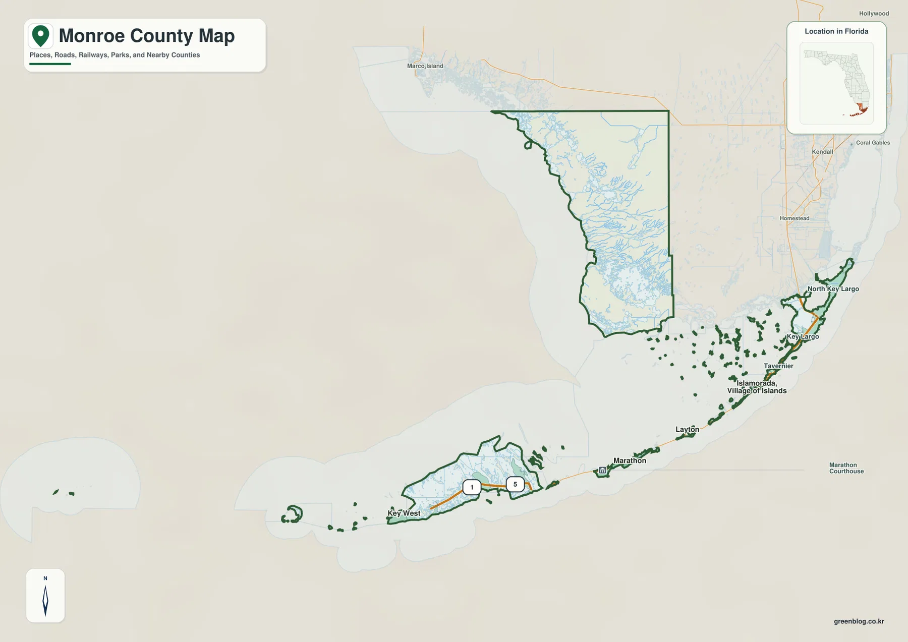
The county also extends beyond the continuous road corridor of the Keys. Flamingo lies on the mainland side in Everglades National Park, while Dry Tortugas National Park is far west of Key West and is reached by boat or seaplane rather than by road. These outlying areas are important reminders that Monroe County is much larger and more varied than the familiar Key West–Key Largo highway corridor alone.
From Key Largo to Key West along one long island corridor
The city map emphasizes how the incorporated communities line up along the Keys. Islamorada occupies the Upper Keys, Layton sits farther southwest on Long Key, and Marathon forms the main municipal center of the Middle Keys. Key Colony Beach is a separate small city near Marathon, while Key West anchors the far southwestern end of the inhabited road corridor. The city index therefore describes a chain of separated island communities rather than neighboring suburbs packed into one continuous urban area.
US 1, the Overseas Highway, is the road that ties most of this sequence together. From Key Largo, it runs southwest through the Upper Keys, continues toward Marathon, crosses major bridge sections, and then passes through the Lower Keys before reaching Key West. The Seven Mile Bridge southwest of Marathon is one of the most recognizable crossings and marks an important transition between the Middle and Lower Keys. Because there is no parallel through-highway for most of the chain, the map’s sequence of towns and bridges closely reflects the actual driving route.
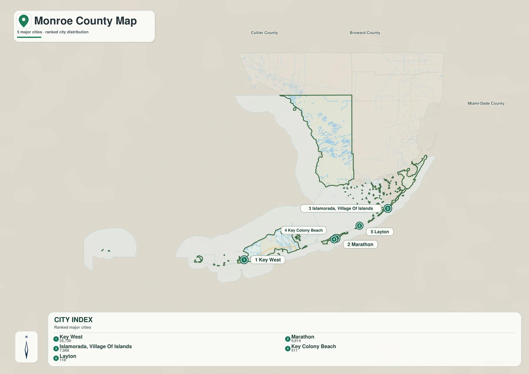
Key Largo is especially important as the gateway from the mainland, even though it is not an incorporated city. Looking north of Key Largo helps explain how the Keys connect back toward Miami-Dade County, while following US 1 southwest makes the order of the Upper, Middle, and Lower Keys easier to understand. The map is therefore useful for sorting out place names that can otherwise feel like a long list of individual islands.
Water defines the mainland side of Monroe County
The water map changes the emphasis completely. Instead of cities and highways, the mainland section is filled with bays, rivers, channels, and marshy coastal water. Labels such as Last Huston Bay, Rodgers River Bay, Tarpon Bay, Wood River, Harney River, North River, and Joe River show how many separate waterways cut through the Everglades side of the county. Chokoloskee Bay and the Gulfport Waterway appear farther northwest, while Biscayne Bay lies to the east of the county’s upper edge.
This dense water network explains why the mainland should not be read like a normal road-based county interior. The settled Florida Keys are organized around US 1 and a sequence of bridges, but the mainland landscape is organized by wetlands, mangrove shorelines, shallow bays, and winding rivers. A short straight-line distance across Florida Bay may still require a long drive because there is no road running directly from the Keys to Flamingo or across the wetland interior.
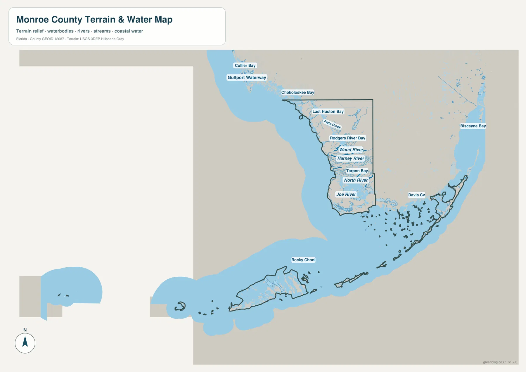
The Keys themselves sit between different bodies of water as well. Florida Bay and Gulf-facing waters lie to the north and northwest of much of the chain, while the Atlantic Ocean and Straits of Florida lie to the south and southeast. Channels between the islands are not simply decorative features on the map; they are part of the physical geography that determines where bridges, roads, marinas, and communities can be located.
What the three Monroe County maps add to each other
The county map is the best starting point when you need the overall boundary and want to see the Florida Keys and the Everglades mainland in one frame. The city map is better for comparing Key West, Marathon, Islamorada, Key Colony Beach, and Layton without the heavier detail of the mainland wetlands. The water map then fills in the geographic context by showing the bays, rivers, and channels that dominate the western mainland and surround the island chain.
Using the maps together also prevents common location mistakes. A reader can see that Key Largo is prominent on the general map but is not one of the ranked incorporated cities, that Flamingo belongs to the mainland side rather than the island chain, and that Key West sits at the end of a long road-linked sequence rather than in the geographic middle of the county. Those distinctions are much harder to notice when every feature is forced onto one crowded map.
When a Monroe County map is especially useful
For travel planning, the most useful approach is to follow US 1 in order rather than estimate distance from the county outline alone. Key Largo, Islamorada, Marathon, the Lower Keys, and Key West form a long sequence, and bridge crossings are a real part of the route. The Seven Mile Bridge is an obvious reference point between Marathon and the Lower Keys, while Key Largo marks the main entry area from the Florida mainland. A map that keeps those points in order is more practical than a simple list of destinations.
For classroom or reference use, Monroe County is a strong example of how an administrative boundary can contain very different landscapes. The county includes incorporated island municipalities, unincorporated Keys communities, an enormous wetland mainland, and remote offshore islands. It also shows why municipal names, island names, and county boundaries should not be treated as the same thing. Key Largo may be one of the best-known names in the county, for example, but Key West is the county seat and the incorporated cities are represented differently on the city map.
The water map is particularly useful for environmental or geographic context. Comparing it with the city map shows that most of the named urban places are concentrated along the road-linked Keys, while the mainland is dominated by wetlands and waterways. That contrast is one of the defining features of Monroe County and helps explain why population, roads, and water features occupy such different parts of the same county.
Frequently Asked Questions
What road connects Key Largo, Marathon, and Key West?
US 1, known through the Keys as the Overseas Highway, is the primary through-road connecting the inhabited island chain. It runs from Key Largo through the Upper and Middle Keys, crosses major bridge sections including the Seven Mile Bridge area, and continues through the Lower Keys to Key West.
Can you drive directly from the Florida Keys to Flamingo?
No direct road crosses Florida Bay from the Keys to Flamingo. A driver must return toward Florida City and Homestead, then enter Everglades National Park from the mainland side and follow the park road toward Flamingo. The two places can look close on a county map while being far apart by road.
Why is Key Largo not ranked with the incorporated cities on the city map?
Key Largo is a prominent unincorporated community rather than an incorporated municipality. The city map ranks the incorporated local governments such as Key West, Marathon, Islamorada, Key Colony Beach, and Layton, so the general map and city map highlight different kinds of place names.
Map File Information
The ZIP below contains the Monroe County general map, city map, and water map as high-resolution A3 JPG files.
- Included Files: county map JPG, city map JPG, water map JPG
Related Maps
- Arcadia Roads and Peace River | DeSoto County Florida Map
- Baker County Florida Map
- Between the Aucilla and Withlacoochee: Madison County Florida Map
Sources and References
- U.S. Census Bureau QuickFacts for Monroe County – county statistics and general reference.
- Monroe County municipalities – incorporated local governments in the county.
- Florida Department of Transportation Seven Mile Bridge information – reference for the Middle-to-Lower Keys crossing.
- National Park Service: Flamingo – mainland Everglades access and location context.
- National Park Service: Dry Tortugas – remote islands west of Key West.
Green Map creates custom-edited map images using open geographic data sources such as geoBoundaries, Natural Earth, OpenStreetMap, and government open data.
These maps are edited visual materials, not raw data files, and are provided for education, documents, presentations, and graphic reference.