You can download the Washington County map set on this page as a ZIP containing four high-resolution A3 JPG files. The county has two very different urban reference points: Johnson City occupies a broad developed area in the northeast, while Jonesborough sits southwest of it as the county seat. The physical maps add another strong contrast, with the South Fork Holston River and Watauga–Boone Lake system toward the north and east, the Nolichucky River along the south, and much higher mountain terrain rising along the southeastern edge.
The general map also labels Gray, Spurgeon, Oak Grove, Telford, and Embreeville, providing useful anchors between the two major centers and the outer county boundary. I-81 crosses the northern side, and the road network becomes especially dense around Johnson City and Jonesborough. The water map traces several named creeks through lower valleys, while the elevation map shows an actual range of about 384 to 1,069 meters and a mean near 523 meters.
Table of Contents
Johnson City and Jonesborough serve two different geographic roles
Johnson City is the largest and most visually dominant developed area on the county map. Its street and road pattern fills much of the northeastern interior, and the supplied map even marks Franklin Woods Community Hospital and East Tennessee State University as local reference points. Jonesborough is smaller and farther southwest, but it remains the county seat, so it is the correct administrative anchor even though Johnson City is the larger urban center.
The communities between and around them help define the county more precisely. Gray and Spurgeon lie north of the central corridor, Oak Grove is close to the northeastern developed area, Telford sits west-southwest of Jonesborough, and Embreeville appears farther south. This pattern creates a chain of settlement areas across the lower interior rather than one single city occupying the entire county.
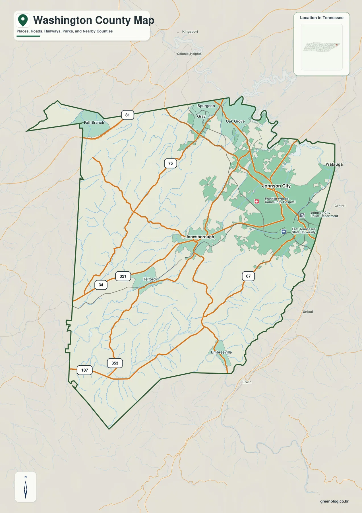
Transportation reflects the same structure. I-81 is visible along the northern side, while the corridor through Jonesborough and Telford includes the 321 route label and other state and federal roads. The Johnson City side has a much denser network that continues toward neighboring areas. Outside labels such as Kingsport, Watauga, Unicoi, and Erwin are useful for direction, but the green county outline should be checked before treating an edge label as part of Washington County.
The city map makes the Johnson City–Jonesborough size difference unmistakable
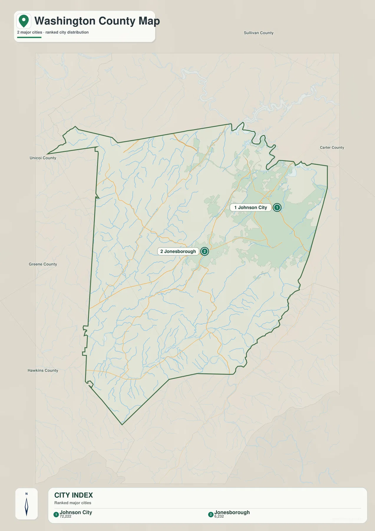
The supplied city map ranks only two major cities. Johnson City is labeled at 72,222 and Jonesborough at 6,232, a large difference that matches the broader developed footprint visible on the general map. These numbers are the values printed on the supplied city graphic and are best used for map comparison. They are not the same as the countywide population, and the map should not be read as proof that every part of Johnson City lies entirely within Washington County.
Location matters as much as the ranking. Jonesborough lies closer to the middle of the county, while Johnson City is positioned farther northeast near the Watauga-side drainage and adjoining counties. The two centers are linked by roads through relatively low terrain, but they represent different functions: Jonesborough is the government seat, while Johnson City is the much larger urban concentration.
The countywide figures provide a different scale. The existing reference material gives a 2020 census population of 133,001 and a July 2025 estimate of 141,199. Washington County contains about 326.5 square miles of land and 3.3 square miles of water. Dividing the 2020 count by the land area gives roughly 407 residents per square mile, but that average does not describe the dense Johnson City area, the western rural landscape, and the southeastern mountains equally.
Holston, Watauga, and Nolichucky waters frame three sides of the county
The terrain-and-water map makes the northern and eastern boundaries especially clear. South Fork Holston River runs near the north side, while Watauga River and Boone Lake occupy the northeastern and eastern edge. These larger waters create broad bends and reservoir-like reaches that are easy to miss on a road-only map and help explain the irregular shape of the county boundary in that area.
Inside the county, Boone Creek, Mud Creek, Cherokee Creek, Little Cherokee Creek, Big Limestone Creek, and Little Limestone Creek follow lower corridors between the ridges. Shallow Creek appears in the northwestern interior. Along the southern side, Nolichucky River forms another major water reference. The smaller streams generally match the branching valleys visible in the shaded terrain, making the water map useful for understanding where roads and settlement can fit between higher ground.
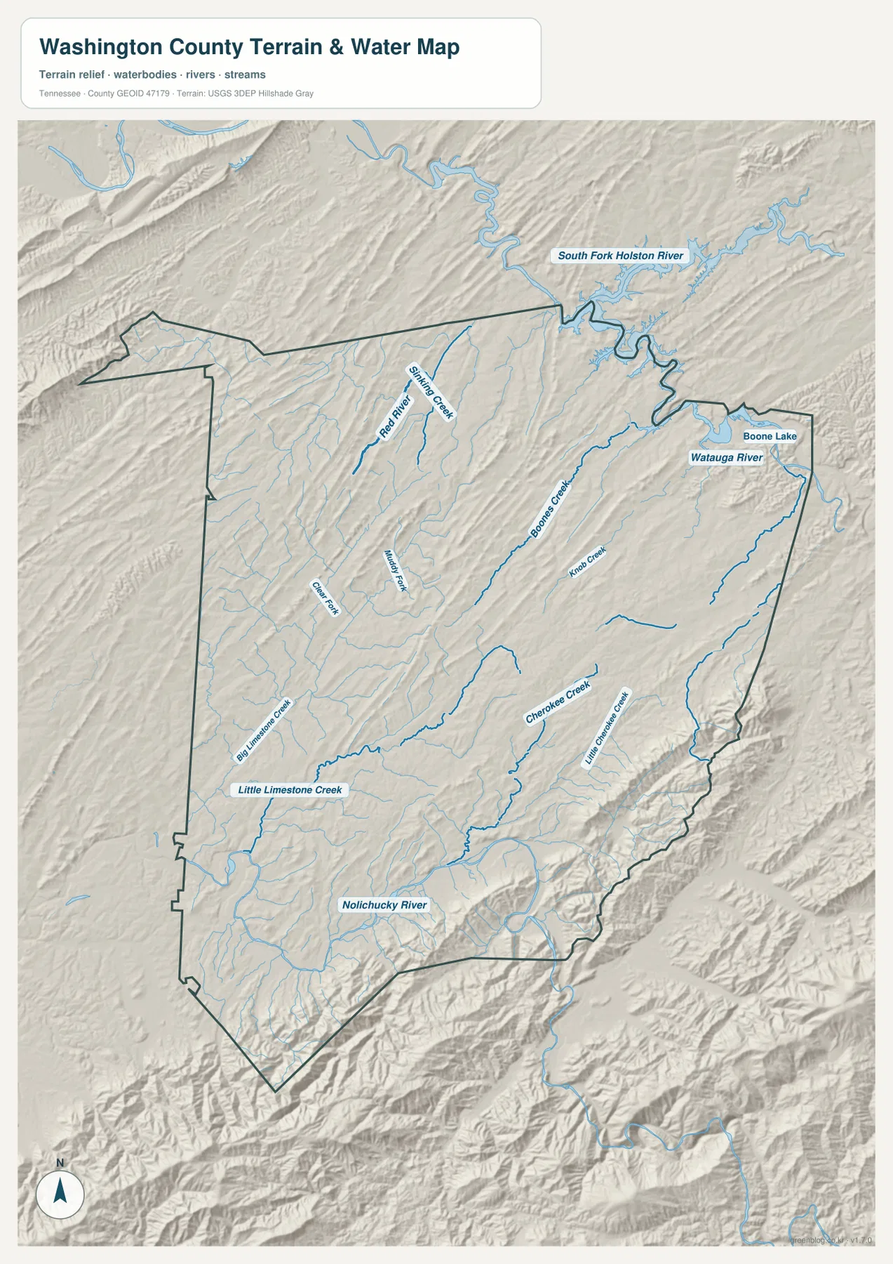
Water covers only a small share of the total county area, but the location of a river or reservoir can matter more than its percentage. Crossings are limited to particular roads and bridges, and shoreline geometry can force detours. This static reference map does not show current water levels, flood boundaries, navigation conditions, channel depth, or legal parcel lines, so those questions require current official sources.
Elevation climbs sharply from the interior valleys into the southeast mountains
The elevation map gives Washington County an actual mapped range of about 384 to 1,069 meters and a mean near 523 meters. Much of the center and west is green, with long narrow ridges running diagonally across lower rolling terrain. The county is therefore not flat, but the relief remains moderate compared with the much steeper southeastern edge.
The greatest rise occurs along the southeast and southern boundary, where tan and dark-brown ridges become continuous and some terrain exceeds 1,000 meters. Lower valleys near the Nolichucky drainage cut into this high ground, producing sharp local contrasts. Moving toward Carter and Unicoi counties, the map becomes distinctly more mountainous than the Johnson City–Jonesborough interior.
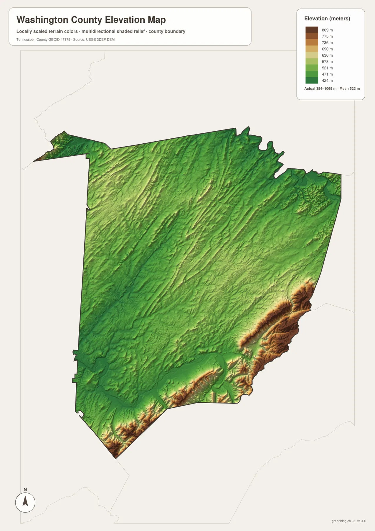
The supplied county references identify the Ridge-and-Valley Appalachians, Blue Ridge Mountains, and Bald Mountains as useful regional terrain names. The map’s long parallel ridges and southeastern rise fit that broader setting. This generalized elevation surface is appropriate for county-scale comparison, but it should not be used for parcel surveying, engineering grade, construction design, or an exact property elevation.
Roads and settlements concentrate in the lower corridors between ridges
The dense road network around Johnson City and Jonesborough is easier to understand when it is compared with elevation. Central Washington County provides a broader band of lower, rolling ground than the southeast mountains, and several creek valleys cross the same area. Major roads can therefore connect the two urban centers and continue north or west without repeatedly climbing the highest ridges.
The pattern changes toward the southeastern border. High ridges narrow the available passages, so roads follow valleys and gaps rather than the shortest straight line. Two places can look close in plan view while a ridge forces the actual route to bend considerably. This is especially important when comparing the Johnson City side with the mountain approaches toward Unicoi County.
Washington County was established in 1777, and Jonesborough is the county seat in the supplied reference material. That historical administrative center is not the same thing as the county’s largest modern city. Keeping Jonesborough’s government role separate from Johnson City’s larger urban footprint prevents a common map-reading mistake and makes the city layer much more informative.
Choosing the Washington County map that answers your question
Use the general county map when you need Johnson City, Jonesborough, Gray, Telford, major roads, and the county boundary in one view. The city map is the quickest option for comparing the two ranked urban centers. The water map is better for Watauga River, Boone Lake, South Fork Holston River, Nolichucky River, and the named creeks, while the elevation map explains the major difference between the lower interior and the high southeastern border.
For printed notes, separating transportation and physical geography produces a cleaner result. One copy can emphasize Johnson City, Jonesborough, I-81, and the main east-west or north-south road corridors. Another can mark Watauga River, Boone Lake, Nolichucky River, the central creek valleys, and the southeastern mountains. This makes the relationship between settlement and terrain easier to see without covering one map with repeated labels.
When comparing Washington County with its neighbors, begin with the county boundary and then note the directions of Sullivan, Carter, Unicoi, Greene, and Hawkins counties. After that, add the internal anchors that are clearly shown on the supplied map. This order helps keep nearby outside labels from being mistaken for Washington County communities.
Frequently Asked Questions
What is the difference between Johnson City and Jonesborough on the map?
Johnson City is the much larger urban area in the northeastern part of the county, while Jonesborough is the smaller county seat farther southwest. The city map emphasizes the difference in scale, and the general map shows how roads connect the two through the lower interior.
Where are Watauga River and Boone Lake relative to Washington County?
They are most prominent along the northeastern and eastern side of the county. South Fork Holston River is visible farther north, and Nolichucky River is the major southern water reference. The map is for geographic comparison and does not provide live water level or flood information.
Where is the highest terrain on the elevation map?
The highest terrain is concentrated along the southeastern and southern boundary. The supplied elevation map ranges from about 384 to 1,069 meters, with a mean near 523 meters, while the central and western parts of the county are generally lower. Parcel-level elevation requires more detailed source data.
Map File Information
The ZIP contains the high-resolution JPG originals for the Washington County map, city map, water map, and elevation map shown on this page. The four A3-format images are better suited to printing, enlarged viewing, and annotation than the WebP previews in the article.
- Included Files: County map, city map, water map, and elevation map
- File Type: ZIP containing 4 JPG images
Related Maps
Sources and References
- Tennessee State Library and Archives Washington County fact sheet
- Tennessee Department of Transportation Washington County map
- U.S. Census Bureau Washington County QuickFacts
- USGS National Hydrography
- USGS 3D Elevation Program
Green Map creates custom-edited map images using open geographic data sources such as geoBoundaries, Natural Earth, OpenStreetMap, and government open data. These maps are edited visual materials, not raw data files, and are provided for education, documents, presentations, and graphic reference.