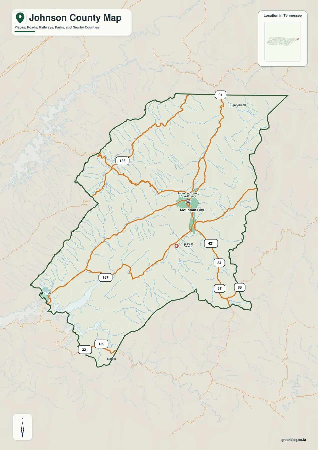
Download the high-resolution A3 JPG ZIP for this Johnson County Tennessee Map directly from the page; it contains the county, city, water, and elevation maps shown below. Mountain City is the main settlement and county-seat reference, Butler appears toward the Watauga Lake side, and Norris marks the southern projection. Routes 421, 91, 133, 167, 34, 67, 88, 321, and 159 cross a landscape of narrow valleys and long mountain ridges rather than a broad flat road grid.
Johnson County is defined by relief. Watauga Lake occupies the southwestern side, creeks cut deep passages through the interior, and high ridges rise across the north, east, and southeast. The elevation layer spans about 595 to 1,664 meters, so a road or creek that looks close on the page may be separated from another by a substantial ridge. Reading the road, water, and elevation maps together makes the county far easier to understand.
Table of Contents
Mountain City is the single ranked city and the main internal reference
The city map ranks Mountain City at 2,542 residents and does not show another ranked major city inside Johnson County. That makes this layer a clean orientation map rather than a multi-city comparison. Mountain City sits slightly east of the county’s center, and the base map also labels the Johnson County Courthouse in the same general area.
The base map adds smaller place references that are useful in the mountains. Butler lies toward the southwest near the Watauga Lake side, while Norris appears in the narrow southern projection. Sugar Creek is labeled in the north. Together, these names give outer reference points around Mountain City without turning the city layer into a dense list of small communities.
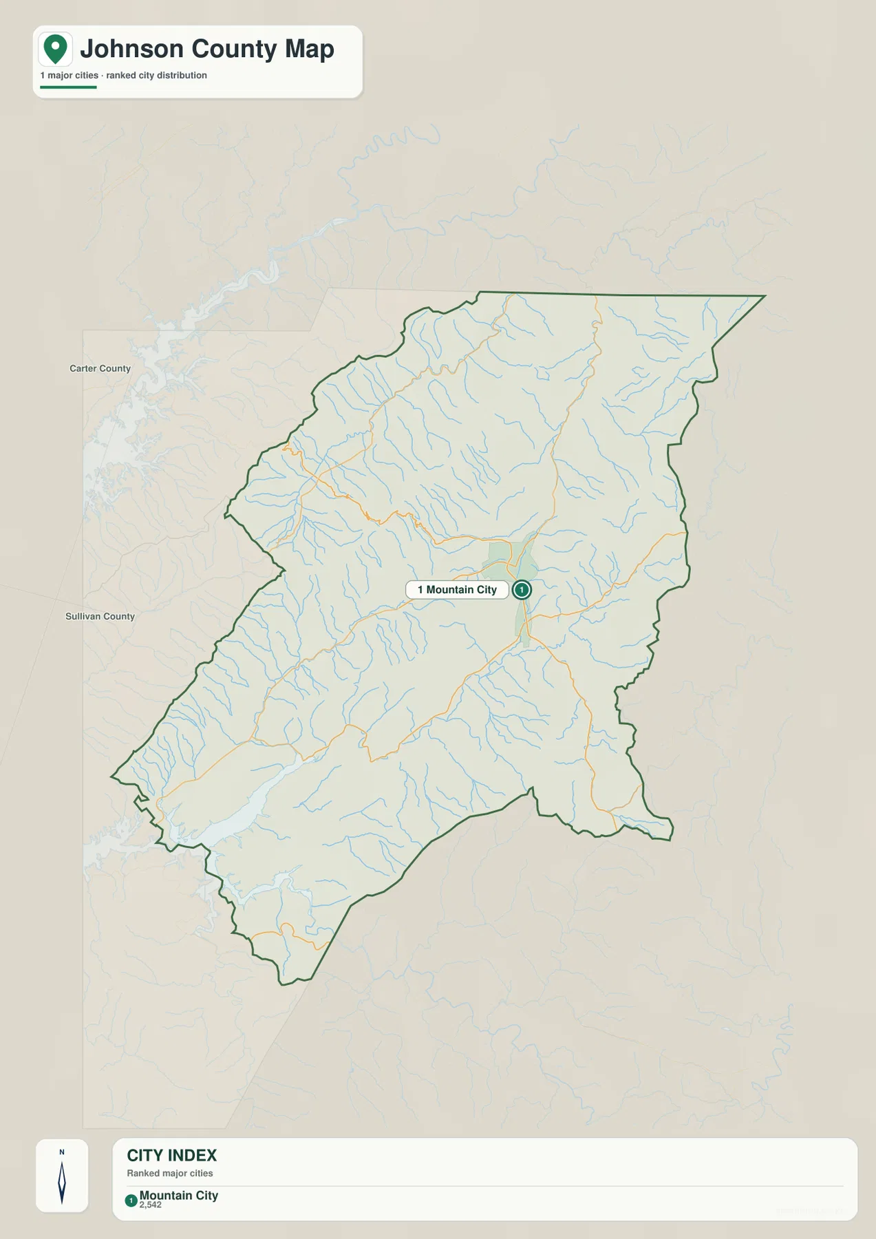
Carter County and Sullivan County are labeled to the west of the county outline on the city map, helping place Johnson County within northeastern Tennessee. The county itself stretches far to the northeast and narrows into a southern extension. That irregular shape fits the strongly dissected mountain terrain visible on the other map layers.
Routes 421 and 91 anchor a road network shaped by mountain valleys
Route 421 is one of the clearest road references near Mountain City. It approaches from the south and passes the county-seat area, while Route 91 continues north from Mountain City toward the upper part of the county. Route 34 is labeled southeast of town, and Routes 67 and 88 appear farther south and east near the county edge.
The western side uses Routes 167 and 133 as useful anchors. Route 167 connects the Butler side with the Mountain City corridor, while Route 133 follows a more winding northwestern approach. In the southern extension, Routes 321 and 159 provide simple references near Norris and the outer boundary.
These roads should not be read as if they crossed a level county. Long ridges force many sections to use valleys and lower gaps, and the bends become especially obvious in the north and east. Starting with Mountain City and one major route, then adding the destination-side road, is much more practical than trying to trace every local line at once.
Watauga Lake and long creek valleys divide the mountain ridges
Watauga Lake is the largest visible water body on the supplied water map. It reaches the southwestern side of the county through narrow mountain valleys and provides the clearest water reference near Butler. Moving inland, the pattern changes from one large reservoir to many separate creeks that occupy their own narrow valleys.
Beaverdam Creek follows a long northwestern valley, with Granny Branch joining the same general drainage area. Corn Creek appears closer to the center, and Furnace Creek continues through an east-central valley. In the northeast, Laurel Creek, Dry Branch, and Gentry Creek occupy lower corridors between much higher ridges.
Roan Creek is one of the more prominent waterways in the south-central and eastern half. Forge Creek runs near the eastern edge, while Doe Creek drains a southwestern mountain valley. Wagner Creek and Stout Branch create additional lower passages south of the Roan corridor, and Baker Branch provides a smaller reference east of Watauga Lake. These labels make the ridge-and-valley pattern much easier to match with the elevation image.
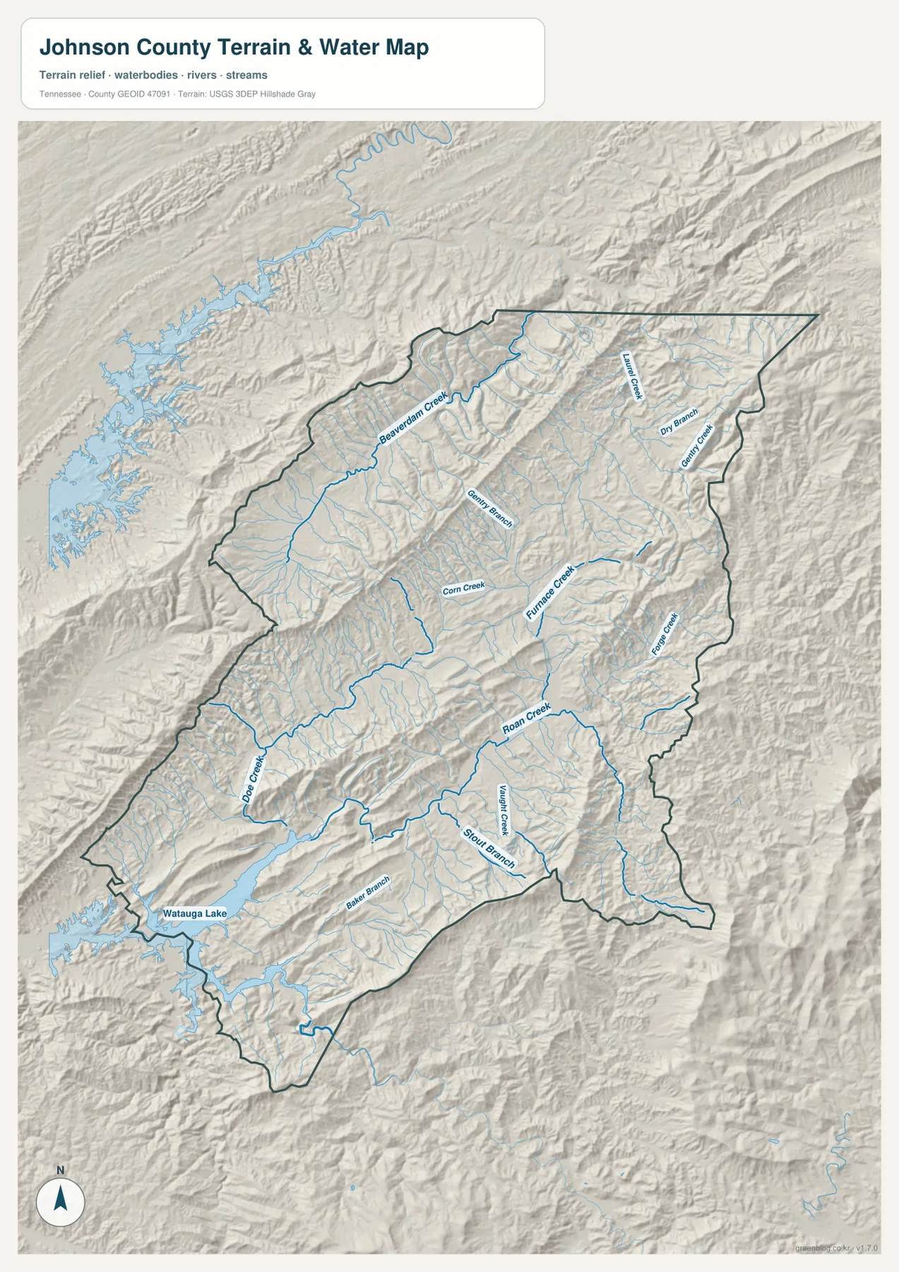
This water layer is intended for geographic reference rather than current lake or road conditions. Watauga Lake level, access points, and mountain-road conditions can change, so field use requires current information from the relevant agencies. Here the layer is used to explain how Mountain City, Butler, and the numbered roads fit between ridges and creek valleys.
A 595–1,664 m range creates one of the strongest relief contrasts in the county series
The elevation map shows an actual range of about 595 to 1,664 meters, with a mean near 885 meters. The lowest green terrain follows Watauga Lake, the main creek valleys, and the broader Mountain City corridor. Brown high ground is concentrated along long ridges in the north, east, and southeast, producing more than a kilometer of countywide elevation difference.
The northern half is a repeating sequence of high ridges and narrow valleys rather than one continuous plateau. Beaverdam Creek and Laurel Creek occupy green passages between much higher slopes. Roads such as 91 and 133 respond to that relief by bending through lower terrain instead of crossing every ridge directly.
The central and southern county are also deeply dissected. Roan Creek and neighboring tributaries create lower corridors south of Mountain City, while long narrow ridges rise immediately beside them. The Watauga Lake side is relatively low, but high terrain returns quickly around the reservoir valleys. Forge Creek on the east similarly occupies a lower slot beside steep county-edge ridges.
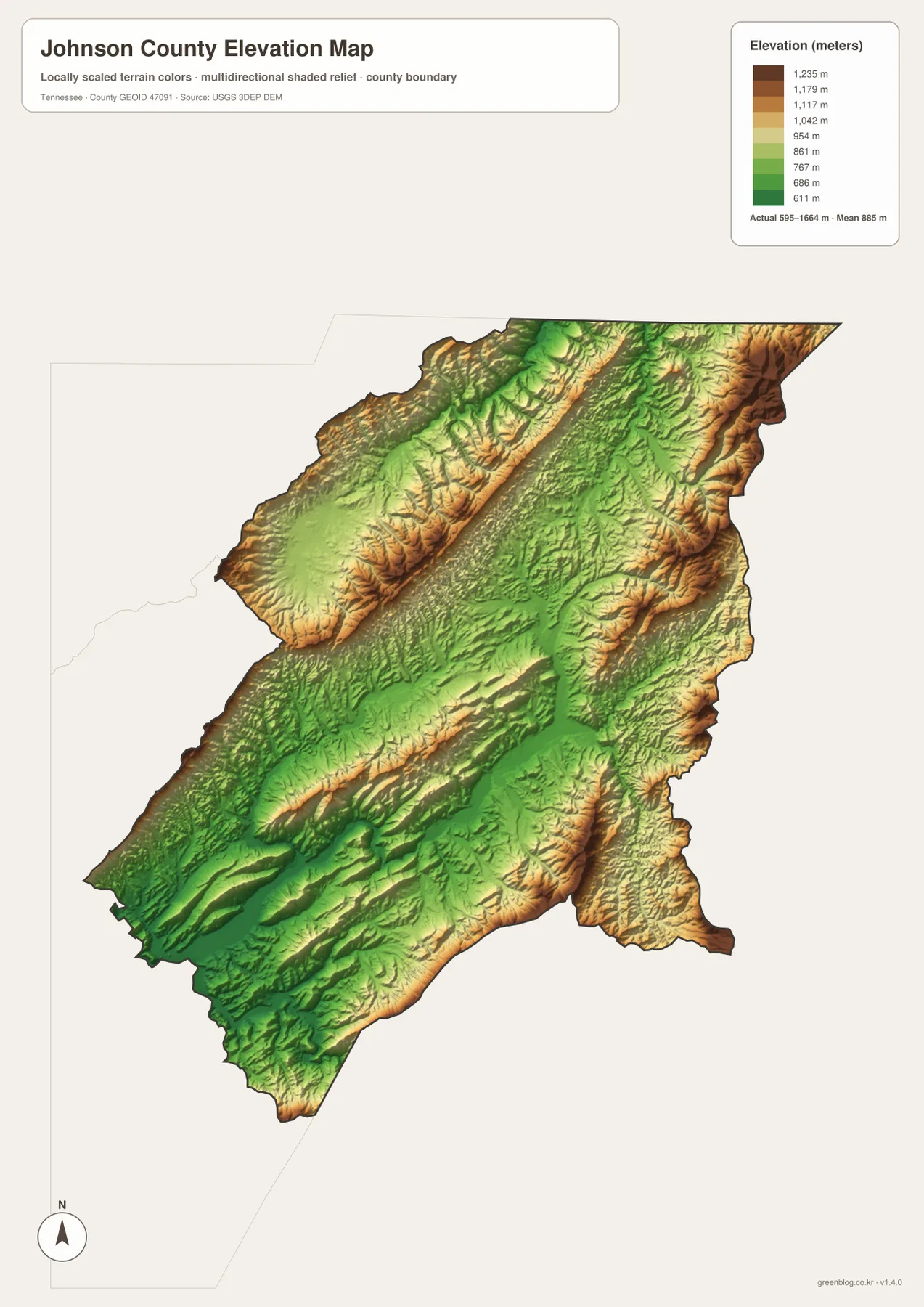
The elevation surface is useful for county-scale comparison, not as a survey-grade elevation for a specific parcel. In Johnson County, however, the relief is large enough that the map directly explains why roads and streams cluster in valleys and why two nearby-looking locations may be separated by a high ridge.
Mountain City connects three different mountain directions
The city layer establishes Mountain City as the central reference. The county map then adds Butler, Norris, and the numbered roads; the water layer shows Watauga Lake and the creek valleys; the elevation image explains the ridges between them. Together, the maps turn a complicated mountain outline into a set of understandable corridors.
Southwest of Mountain City, Route 167, Butler, and Watauga Lake form one useful group. Northward, Route 91 and the Beaverdam–Laurel creek valleys provide another. To the southeast, Routes 421, 34, 67, and 88 combine with Roan and Forge creeks and the high boundary ridges. Each direction has a different mix of road, water, and elevation references.
Use the city map when Mountain City’s position is the main question, the county map for road numbers and outer place labels, the water map for Watauga Lake and the named creek valleys, and the elevation map when the steep difference between valley floors and high ridges matters most.
A3 JPG originals for mountain-road and terrain reference
The WebP previews are sized for quick browser reading. The A3 JPG originals are more useful when Routes 421 and 91 or smaller names such as Beaverdam and Roan creeks need to be enlarged or annotated. Keeping road notes on the county map and drainage notes on the water image also prevents labels from becoming crowded.
The elevation JPG is especially valuable here because the color range separates low reservoir and creek valleys from very high mountain ridges. The city image is the cleanest choice when a presentation only needs to show where Mountain City sits inside the county.
The ZIP below packages the A3 JPG originals used to compare Mountain City, the county road network, Watauga Lake and creek valleys, and Johnson County’s steep relief. They are suitable for classroom comparison, presentations, local orientation, route notes, and offline reference when the browser images are too small.
Frequently Asked Questions
Why is Mountain City the only ranked city on the city map?
The supplied city layer ranks Mountain City at 2,542 residents. Smaller place labels such as Butler and Norris appear on the base county map instead, so the city layer provides a simple central reference while the county map adds more local detail.
How large is the elevation range in Johnson County?
The elevation map shows roughly 595–1,664 meters, with a mean near 885 meters. Watauga Lake and major creek valleys occupy lower green terrain, while the northern, eastern, and southeastern ridges rise much higher, creating more than 1,000 meters of countywide relief.
Sources and reference data
County history and local reference material are available from the Tennessee State Library and Archives Johnson County fact sheet. Road placement can be compared with the Tennessee Department of Transportation Johnson County map, and county boundaries with U.S. Census Bureau TIGER/Line.
For additional hydrography reference, see USGS National Hydrography. Elevation data can be compared with the USGS 3D Elevation Program. The descriptions here follow Mountain City, Watauga Lake, the mapped roads and creeks, and the elevation differences visible in the supplied Johnson County maps.
Map File Information
The archive contains the A3 JPG originals for the Johnson County road, city, water, and elevation maps shown on this page.
- Included Files: County map, city map, water map, elevation map
- File Type: ZIP containing 4 JPG files
Related Maps
Green Map creates custom-edited map images using open geographic data sources such as geoBoundaries, Natural Earth, OpenStreetMap, and government open data. These maps are edited visual materials, not raw data files, and are provided for education, documents, presentations, and graphic reference.