Download the high-resolution A3 JPG ZIP for this Lake County Tennessee Map directly from the page; it contains the county, city, water, and elevation maps shown below. Tiptonville and Ridgely are the two ranked city references, the Mississippi River forms the winding western edge, and Reelfoot Lake occupies much of the eastern side. Between them, chutes, sloughs, bayous, and drainage channels spread across one of Tennessee’s lowest and flattest county landscapes.
Lake County is easier to understand by following water than by looking for hills. The Mississippi River bends around the west, Reelfoot Lake creates a broad eastern water boundary, and the land between them sits mostly within a narrow elevation range. Tiptonville anchors the northern half, Ridgely the south, and Route 78 provides a simple road connection through the center of the lowland.
Table of Contents
Tiptonville and Ridgely provide the two main city references
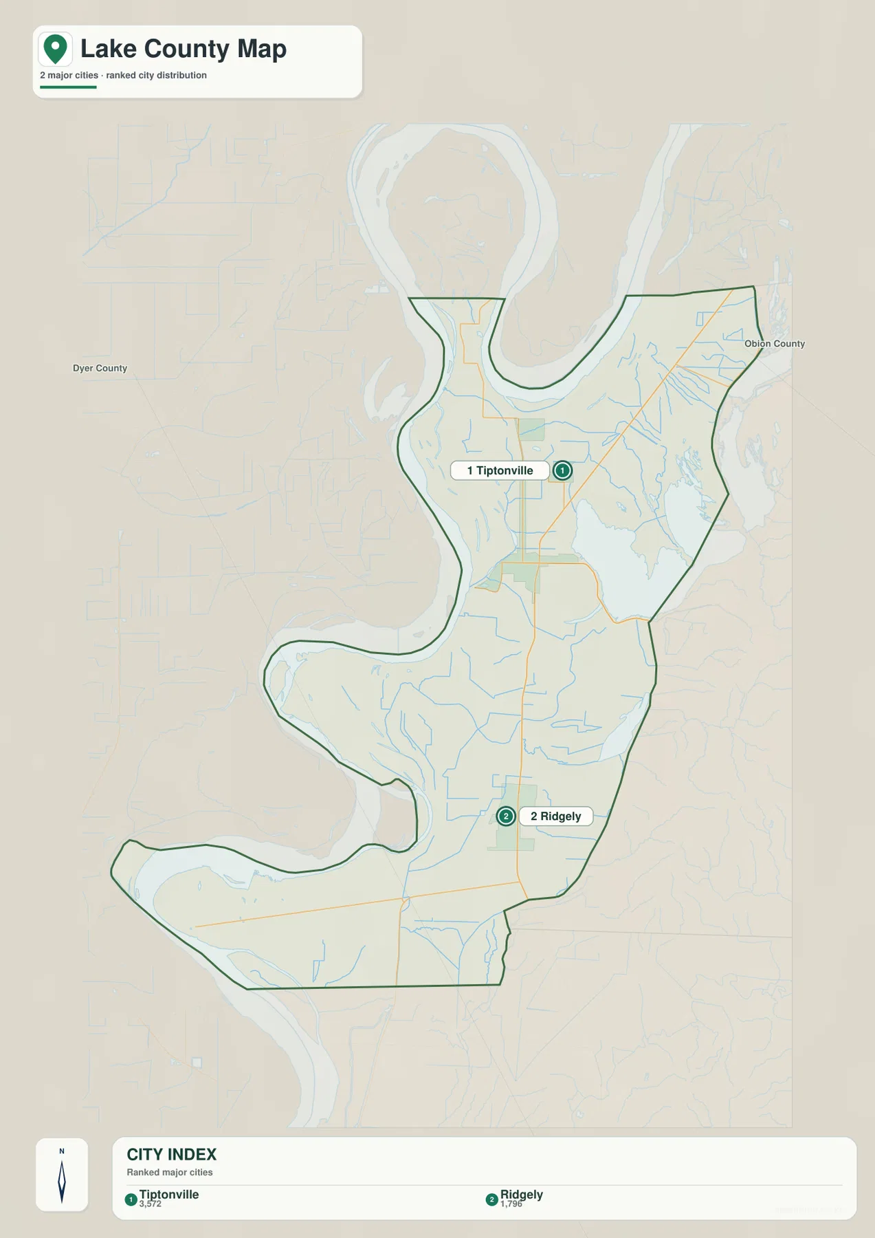
The city map ranks Tiptonville at 3,572 residents and Ridgely at 1,796. Tiptonville is the county seat and the larger ranked city, while Ridgely lies farther south. Their north–south relationship gives the map a simple settlement framework before the road and water layers are added.
Dyer County and Obion County are labeled outside the county outline, helping place Lake County within northwestern Tennessee. The shape of the county is unusually irregular because the Mississippi River forms large western bends and the Reelfoot Lake side creates another complex water edge. Thinking of the county as a strip of low land between major waters makes the outline much easier to interpret.
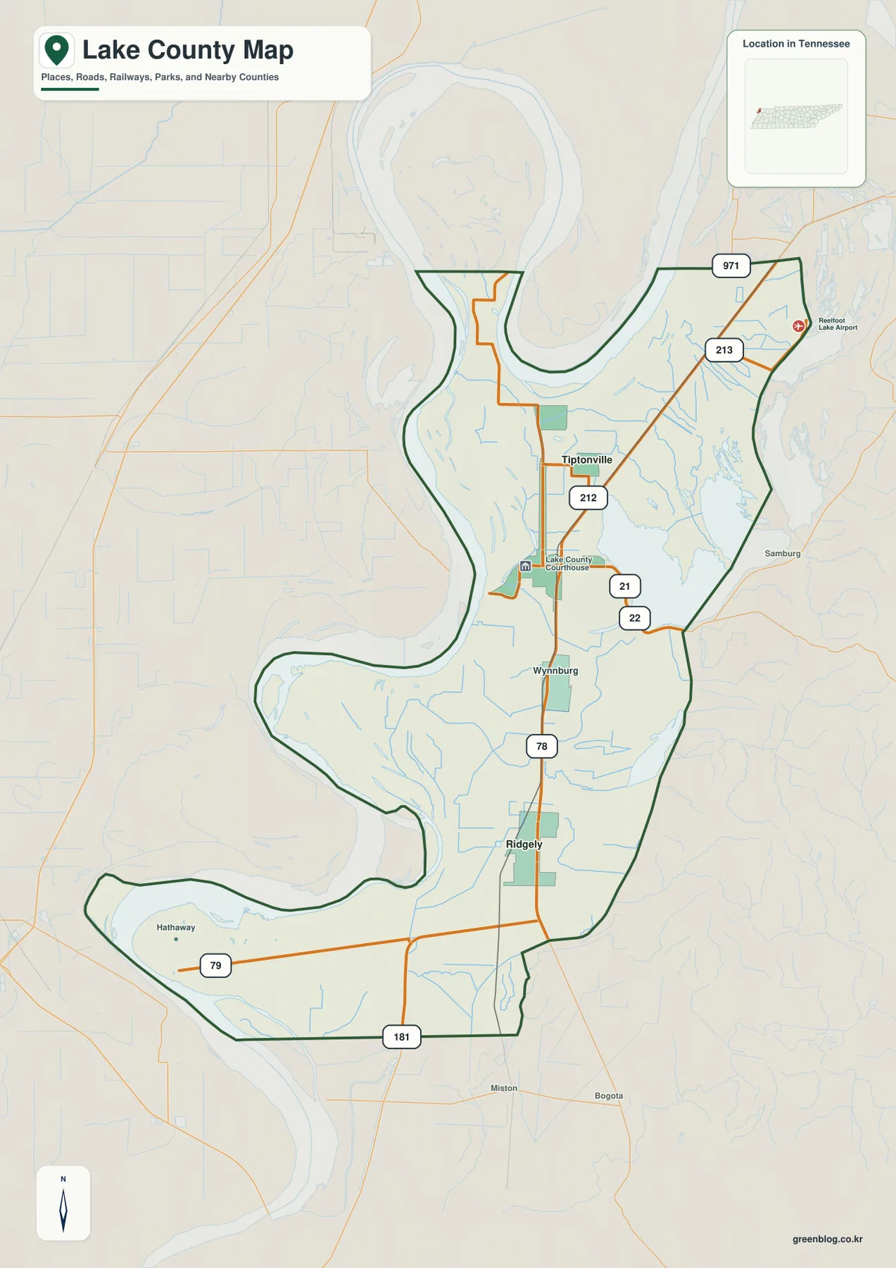
The base map adds Wynnburg and Hathaway as smaller place references. Wynnburg lies along the central Route 78 corridor between Tiptonville and Ridgely, while Hathaway appears in the southwestern projection. These local names are useful for dividing the long county into smaller sections without crowding the city ranking map.
Route 78 links the county center while smaller roads reach the lake and river edges
Route 78 is the clearest north–south road on the base map. It runs through the Tiptonville–Wynnburg–Ridgely corridor and provides the easiest internal reference for the county. Route 212 is labeled near Tiptonville, while Routes 21 and 22 extend toward the Reelfoot Lake side.
Routes 213 and 971 appear in the northeastern section near the Reelfoot Lake Airport. Route 79 crosses the southwestern projection near Hathaway, and Route 181 marks the southern boundary area. The roads are not shaped by mountain relief, but they still respond to broad river bends, wet lowlands, drainage channels, and limited crossing points.
The Lake County Courthouse is labeled in the Tiptonville area and provides a useful administrative reference. For quick orientation, use Route 78 for the central north–south corridor, Routes 212–213–21–22 for the northern lake side, and Routes 79–181 for the southern and southwestern lowlands.
The Mississippi River and Reelfoot Lake frame a network of chutes, sloughs, and bayous
The Mississippi River is the dominant western water feature. It loops around the northwestern, central-western, and southwestern edge of Lake County, creating several broad bends. Pecan Chute and Tiptonville Chute appear inside the river-side lowland, while Beaver Slough marks another northern wet corridor close to the main channel.
Reelfoot Lake is the major eastern water body. Big Sandy Creek and Black Slough appear near the northeastern side, and Black Bayou follows a low corridor beside the lake. These features show that the lake margin is not a simple straight shoreline but a mix of open water, channels, and wet lowlands.
Old Gangway Slough crosses the central county, while Blue Bank Bayou and Running Reelfoot Ditch provide southern references. Together with the Mississippi-side chutes, these channels reveal how thoroughly the lowland is divided by water. Roads, settlements, and dry land occupy the spaces between a much denser drainage network than the county map alone suggests.
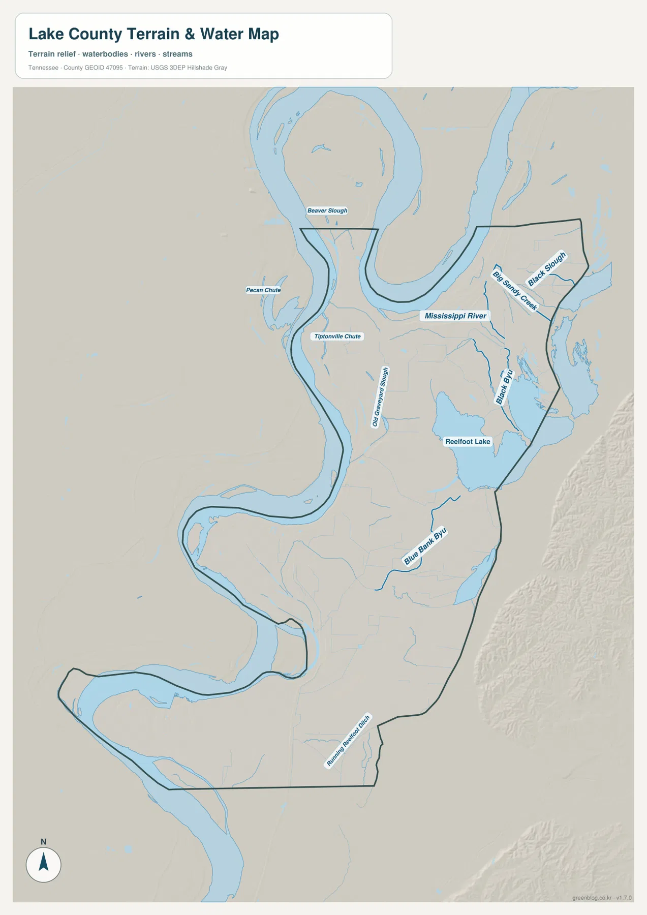
This water layer is intended for geographic reference rather than current river or lake conditions. Mississippi River stage, Reelfoot Lake access, and conditions on individual channels can change, so field use requires current local or agency information. Here the map is used to explain how Tiptonville, Ridgely, and the main roads sit between major water bodies and lowland channels.
A 77–98 m range reveals subtle floodplain relief rather than hills
The elevation map shows an actual range of about 77 to 98 meters, with a mean near 85 meters. The total countywide relief is only about 21 meters, making this landscape fundamentally different from Tennessee’s ridge and mountain counties. Lower green terrain follows parts of the Mississippi River edge and the southwestern lowlands, while slightly higher brown terrain appears in narrow interior bands.
The Tiptonville area and the land immediately south of it contain one of the more noticeable higher strips on the map. The Reelfoot Lake side is broad and gently shaded, while the western floodplain shows a more complicated pattern of low channels, levee-like rises, and old river features. These are small vertical differences, but they matter much more in such a flat county.
The southern half remains mostly within green and yellow-green elevation bands, including the Route 79 and Route 181 side. Flat does not mean identical everywhere: a few meters of relief can influence how water collects and moves across a floodplain. That is why the elevation map is most useful when read beside the slough, bayou, and ditch network.
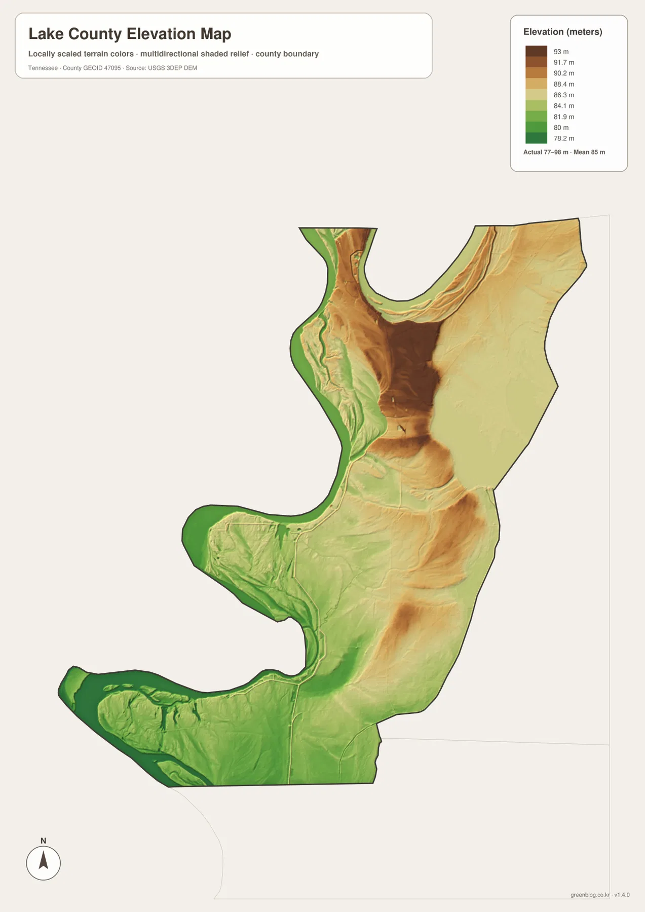
The elevation surface is intended for county-scale comparison rather than survey-grade elevation at a specific property. In Lake County, the best use is not finding mountains or ridges, but identifying slightly higher natural levees and interior strips beside lower river and drainage corridors.
Tiptonville and Ridgely sit inside a water-shaped lowland corridor
The city layer first establishes Tiptonville and Ridgely. The county map adds Wynnburg, Hathaway, and the numbered road network. The water map then reveals the Mississippi River, Reelfoot Lake, and the many channels between them, while the elevation image shows that all of those features occupy a very low, nearly level landscape.
North and west of Tiptonville, the Mississippi bends, Tiptonville Chute, and Beaver Slough are strong location references. Eastward, Reelfoot Lake and Black Bayou are more useful. Around Ridgely and the south, Route 78, Blue Bank Bayou, and Running Reelfoot Ditch provide simple anchors for reading the lower half of the county.
Use the city map for the two ranked places, the county map for roads and smaller place labels, the water map for the river–lake–slough network, and the elevation map when the subtle floodplain height differences are the main question.
A3 JPG originals for lowland road and water reference
The WebP previews are sized for quick browser reading. The A3 JPG originals provide more room when Routes 212 and 213 or smaller water labels such as Old Gangway Slough and Blue Bank Bayou need to be enlarged or annotated. Keeping route notes on the base map and drainage notes on the water image also makes the dense lowland network easier to read.
The elevation JPG is useful even though the county is very flat, because its color range separates lower floodplain corridors from slightly higher interior ground. The city image is the cleanest choice when a presentation only needs Tiptonville and Ridgely.
The ZIP below packages the A3 JPG originals used to compare Tiptonville and Ridgely, the county road network, the Mississippi River–Reelfoot Lake water system, and Lake County’s subtle relief. They are well suited to classroom comparison, presentations, lowland orientation, map notes, and offline reference.
Frequently Asked Questions
Which cities are ranked on the city map?
The supplied city layer ranks Tiptonville at 3,572 residents and Ridgely at 1,796. Smaller place references such as Wynnburg and Hathaway appear on the base county map instead.
Why is the elevation range in Lake County so small?
The elevation map shows roughly 77–98 meters, with a mean near 85 meters. Most of the county lies within the Mississippi River floodplain and the Reelfoot Lake lowland, so the total countywide elevation difference is only about 21 meters.
Sources and reference data
County history and local reference material are available from the Tennessee State Library and Archives Lake County fact sheet. Road placement can be compared with the Tennessee Department of Transportation Lake County map, and county boundaries with U.S. Census Bureau TIGER/Line.
For additional hydrography reference, see USGS National Hydrography. Elevation data can be compared with the USGS 3D Elevation Program. The descriptions here follow Tiptonville, Ridgely, the mapped roads, Mississippi River, Reelfoot Lake, sloughs, bayous, and elevation differences visible in the supplied Lake County maps.
Map File Information
The archive contains the A3 JPG originals for the Lake County road, city, water, and elevation maps shown on this page.
- Included Files: County map, city map, water map, elevation map
- File Type: ZIP containing 4 JPG files
Related Maps
Green Map creates custom-edited map images using open geographic data sources such as geoBoundaries, Natural Earth, OpenStreetMap, and government open data. These maps are edited visual materials, not raw data files, and are provided for education, documents, presentations, and graphic reference.