Download the high-resolution A3 JPG ZIP for this Knox County Tennessee Map directly from the page; it contains the county, city, water, and elevation maps shown below. Knoxville is the dominant city reference, Farragut lies in the southwest, and the base map adds Halls, Powell, Karns, Mascot, and John Sevier around the county. The Tennessee River crosses the central-southern area, while the Holston and French Broad rivers approach from the east through broad low valleys.
Knox County is easier to understand as a combination of urban valley, rivers, and long ridges than as a simple metropolitan outline. Knoxville occupies the lower central corridor. North of the city, parallel ridges become more pronounced, while the southwest around Farragut is broken by reservoir-like water arms and short tributary valleys. The road network follows these landforms closely, especially away from the dense Knoxville center.
Table of Contents
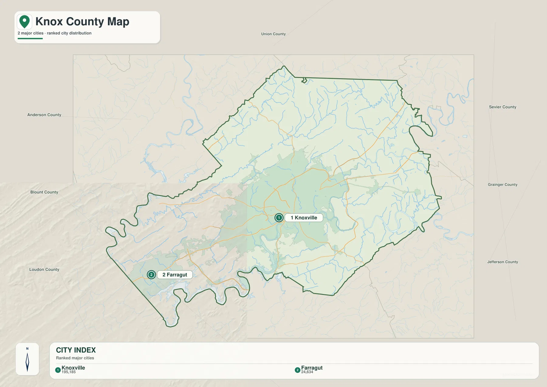
Knoxville dominates the city layer, with Farragut as the southwestern reference
The city map ranks Knoxville at 195,185 residents and Farragut at 24,634. Knoxville is the county’s main urban and government center, while Farragut provides a clear reference near the southwestern edge. The large difference in population also explains why the mapped developed area around Knoxville is much broader than the settlement footprint around Farragut.
Union County is labeled to the north, Anderson County to the northwest, Blount and Loudon counties toward the southwest, and Sevier, Grainger, and Jefferson counties on the eastern side. These surrounding labels frame Knox County within eastern Tennessee. The county outline is especially irregular in the southwest, where water and narrow land projections create a much more indented boundary than the northern side.
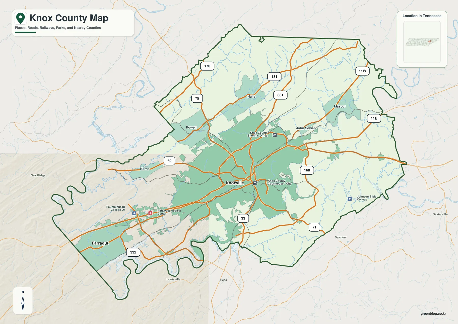
The base county layer adds smaller place names that are useful for orientation. Halls and Powell sit north and northwest of Knoxville, Karns lies to the west, and Mascot and John Sevier appear to the east. Those references turn Knoxville into a practical center point for reading the rest of the map without treating every local road as equally important.
Major roads spread from Knoxville toward Halls, Powell, Karns, and Mascot
Route 75 is one of the clearest northbound references from the Knoxville area toward Powell and Halls. Farther north, Routes 170, 131, and 331 cross separate ridge-and-valley corridors. Route 11W is labeled near Mascot on the northeastern side, while 11E and Route 168 appear farther east and southeast.
Route 62 provides an easy western reference near Karns, and Route 332 appears on the Farragut side. South of Knoxville, Route 33 is clearly labeled, with Route 71 close to the southeastern boundary. These roads do not form a regular grid because rivers, creek valleys, and ridges repeatedly redirect the most practical path.
The base map also labels the Knox County Courthouse and Knox County Sheriff’s Office near the Knoxville center. Parkwest Medical Center and Fountainhead College appear farther west, while Johnson Bible College is shown on the southeastern side. For quick map reading, start with Knoxville, choose the destination direction, and then follow the most prominent numbered road serving that side of the county.
Tennessee, Holston, and French Broad river valleys organize the southern and eastern county
The Tennessee River is the easiest major water feature to follow through the central-southern part of the county. It bends westward below Knoxville and continues toward the broad water area in the southwest. From the east, the Holston River and French Broad River occupy separate low corridors that approach one another before the drainage continues into the Tennessee River system.
The northern half is divided by smaller waterways. Bullrun Creek follows a long northwestern valley, while Little Flat Creek and Flat Creek occupy northeastern corridors between higher ridges. Beaver Creek extends through the western side near the Powell–Karns direction. These streams line up closely with the lower green valleys on the elevation image.
Third Creek lies much closer to the Knoxville center and drains toward the Tennessee River. Stock Creek follows a southeastern valley. Smaller named waters include Bradley Lake, Dead Horse Lake, Jolly Giant Lake, Chilhowee Park Lake, and Charis Lake. Those local features provide useful reference points in areas where the three major rivers are too broad a guide for neighborhood-scale orientation.
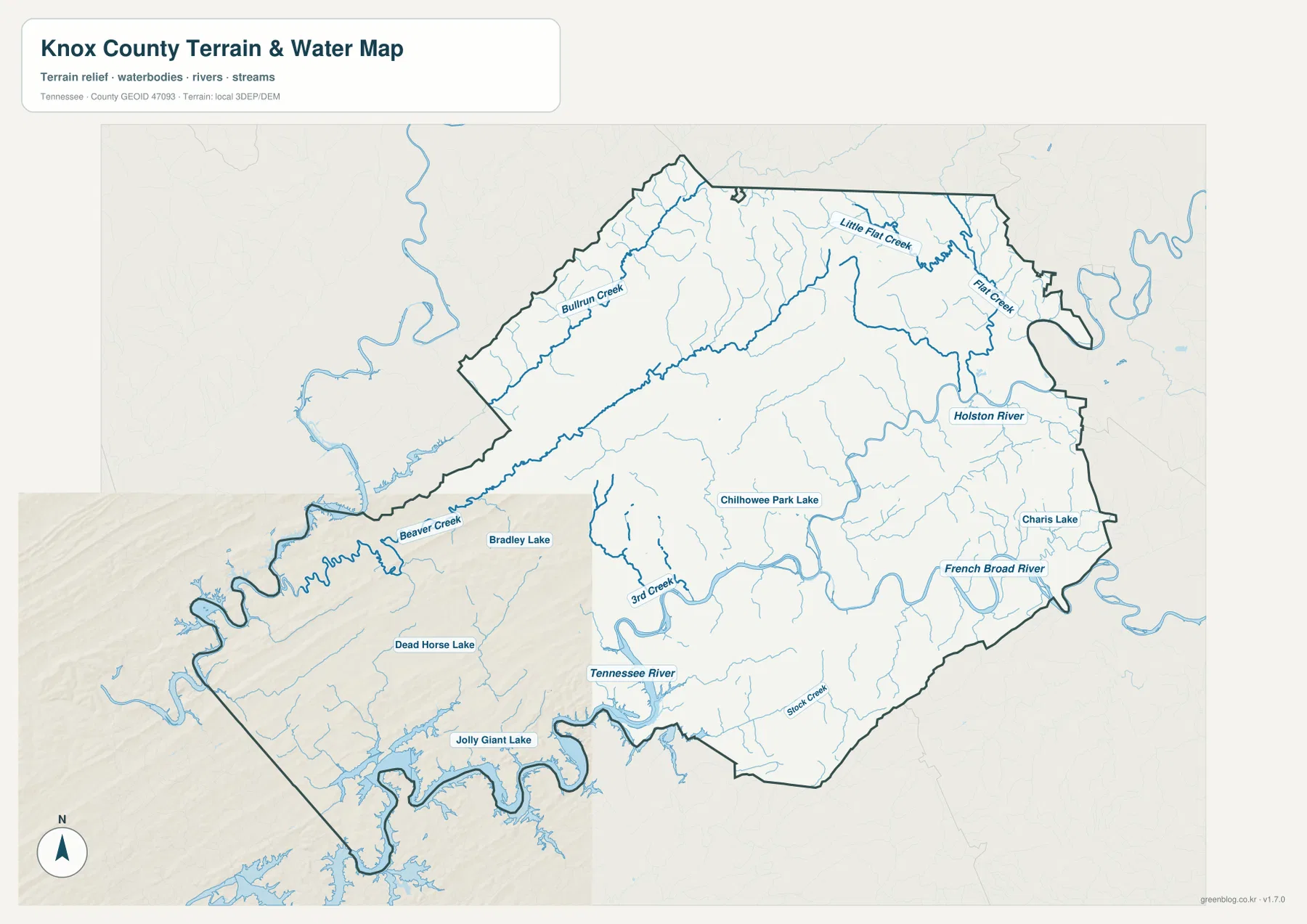
This water layer is intended for geographic reference rather than current river or access conditions. Water level, bridge restrictions, and boating access can change, so field use requires current information from the appropriate agencies. Here the layer is used to show how Knoxville and the outer road corridors fit between the major rivers and tributary valleys.
A 190–636 m range separates low river corridors from long northern ridges
The elevation map shows an actual range of about 190 to 636 meters, with a mean near 306 meters. The lowest green terrain follows the Tennessee River, the Holston and French Broad corridors, and the major creek valleys. North and northwest of Knoxville, long tan and brown ridges run in roughly parallel bands, and another distinct high hill appears toward the northeast.
The Powell and Halls side shows the ridge-and-valley pattern especially well. Bullrun Creek and Beaver Creek occupy lower passages, while higher ground rises immediately beside them. Routes 75, 170, 131, and 331 respond to these landforms by using different corridors rather than behaving like streets on a flat rectangular grid.
Knoxville and the Tennessee River corridor contain broader low terrain than the northern county. The French Broad side in the southeast also follows a green valley, while the Farragut side combines lower water arms with short ridges between tributaries. Knox County is not a high-mountain county, but its roughly 446-meter total relief is enough to make the central river valley and northern ridges visibly different.
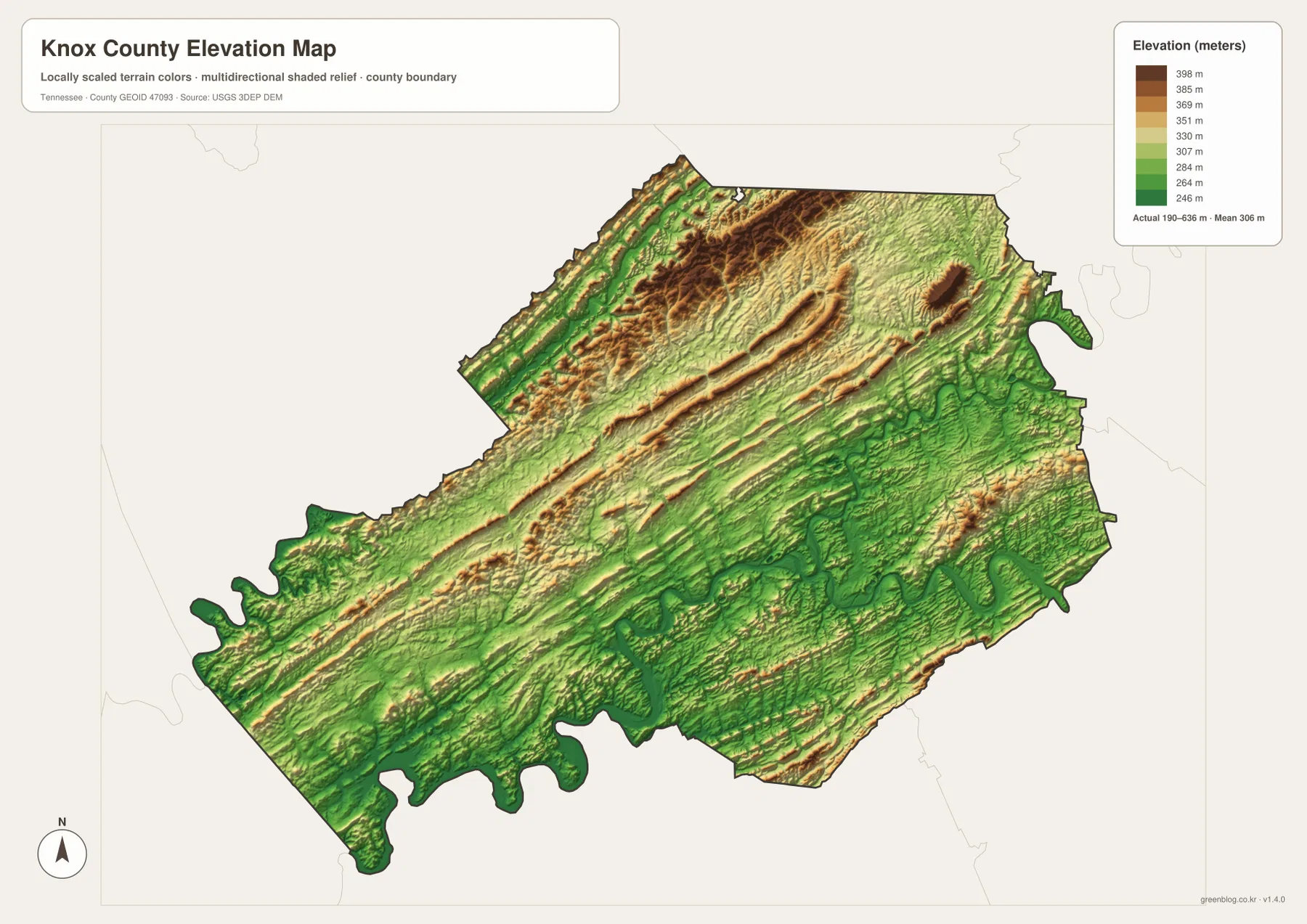
The elevation surface is useful for county-scale comparison rather than a surveyed height at a particular property. It is especially helpful for matching the lower creek corridors with the ridges around Halls and Powell and for understanding why some road routes bend away from a direct line.
Knoxville ties together four different map directions
The city layer establishes Knoxville and Farragut first. The base map adds Halls, Powell, Karns, Mascot, John Sevier, and the road network. The water layer shows how the three major rivers and tributary creeks occupy the lower corridors, while the elevation image explains the ridges separating them.
North of Knoxville, Halls and Powell pair naturally with Routes 75 and 170, Bullrun and Beaver creeks, and the long high ridges. Westward, Karns and Route 62 provide an easy reference. Southwest, Farragut and Route 332 sit among more irregular water arms. Eastward, Mascot and John Sevier are easier to understand beside the Holston and French Broad river corridors.
Use the city map for the two ranked cities, the county map for road numbers and smaller place labels, the water map for the three large rivers and tributaries, and the elevation map when the difference between Knoxville’s low corridor and the northern ridges is the main question.
A3 JPG originals for urban, river, and terrain reference
The WebP previews are sized for quick browser reading. The A3 JPG originals provide more room when place names such as Halls, Powell, and Karns or creek labels such as Bullrun and Third Creek need to be enlarged or annotated. Keeping route notes on the base map and water notes on the hydrography image also prevents the dense Knoxville center from becoming cluttered.
The elevation JPG is particularly useful in color because the low central river corridor remains green while the northern ridges shift into tan and brown. The city layer is the cleanest choice when a presentation only needs Knoxville and Farragut, while the county map works better for road and outer-community context.
The ZIP below packages the A3 JPG originals used to compare Knoxville and Farragut, the road network, the Tennessee–Holston–French Broad river system, tributary valleys, and Knox County relief. For Knox County, the larger originals are most useful when Knoxville roads, river corridors, and the northern ridge pattern need to be compared on the same printed scale.
Frequently Asked Questions
Which cities are ranked on the city map?
The supplied city layer ranks Knoxville at 195,185 residents and Farragut at 24,634. Smaller place labels such as Halls, Powell, Karns, Mascot, and John Sevier appear on the base county map instead.
How large is the elevation range in Knox County?
The elevation map shows roughly 190–636 meters, with a mean near 306 meters. The main river valleys occupy lower green terrain, while northern and northwestern ridges rise substantially higher, producing about 446 meters of countywide relief.
Sources and reference data
County history and local reference material are available from the Tennessee State Library and Archives Knox County fact sheet. Road placement can be compared with the Tennessee Department of Transportation Knox County map, and county boundaries with U.S. Census Bureau TIGER/Line.
For additional hydrography reference, see USGS National Hydrography. Elevation data can be compared with the USGS 3D Elevation Program. The descriptions here follow Knoxville, Farragut, the mapped road network, Tennessee, Holston and French Broad rivers, named creeks, and elevation differences visible in the supplied Knox County maps.
Map File Information
The archive contains the A3 JPG originals for the Knox County road, city, water, and elevation maps shown on this page.
- Included Files: County map, city map, water map, elevation map
- File Type: ZIP containing 4 JPG files
Related Maps
Green Map creates custom-edited map images using open geographic data sources such as geoBoundaries, Natural Earth, OpenStreetMap, and government open data. These maps are edited visual materials, not raw data files, and are provided for education, documents, presentations, and graphic reference.