Thomas County sits in southwest Georgia along the Florida line, with Thomasville serving as the county seat and the main reference point for the places shown here. The four maps on this page go beyond a simple outline: they show the county boundary and numbered roads, the relative positions of Boston, Coolidge, Ochlocknee, and Meigs, a dense network of rivers and creeks, and the county’s elevation pattern. A single ZIP download is also provided with four original A3 high-resolution JPG maps for printing, local research, classroom use, or offline reference.
Thomasville stands out because several major numbered routes meet or pass close to the city before spreading toward smaller communities. North and northwest lie Ochlocknee and Meigs, Coolidge is to the northeast, and Boston and Pavo are farther east. The water and elevation maps add another layer to that settlement pattern: the Ochlockonee system defines much of the western side, the Aucilla River appears in the southeast, and lower green valleys cut through the otherwise rolling terrain. Looking across the maps together gives a clearer picture of how roads, towns, waterways, and relief fit inside the same county boundary.
Table of Contents
Thomasville as the road and place-name anchor
The county reference map makes Thomasville the easiest place to orient yourself. Route numbers 319, 35, 122, 3, and 19 appear close to the city, while the eastward corridor toward Boston includes 38 and 84. Farther north, 111 and 202 appear near the Ochlocknee–Meigs side of the county, and 188 crosses the northeastern side toward Pavo. The map is not intended to replace a detailed street atlas, but it clearly shows that Thomasville connects several different travel directions rather than sitting at the end of a single corridor.
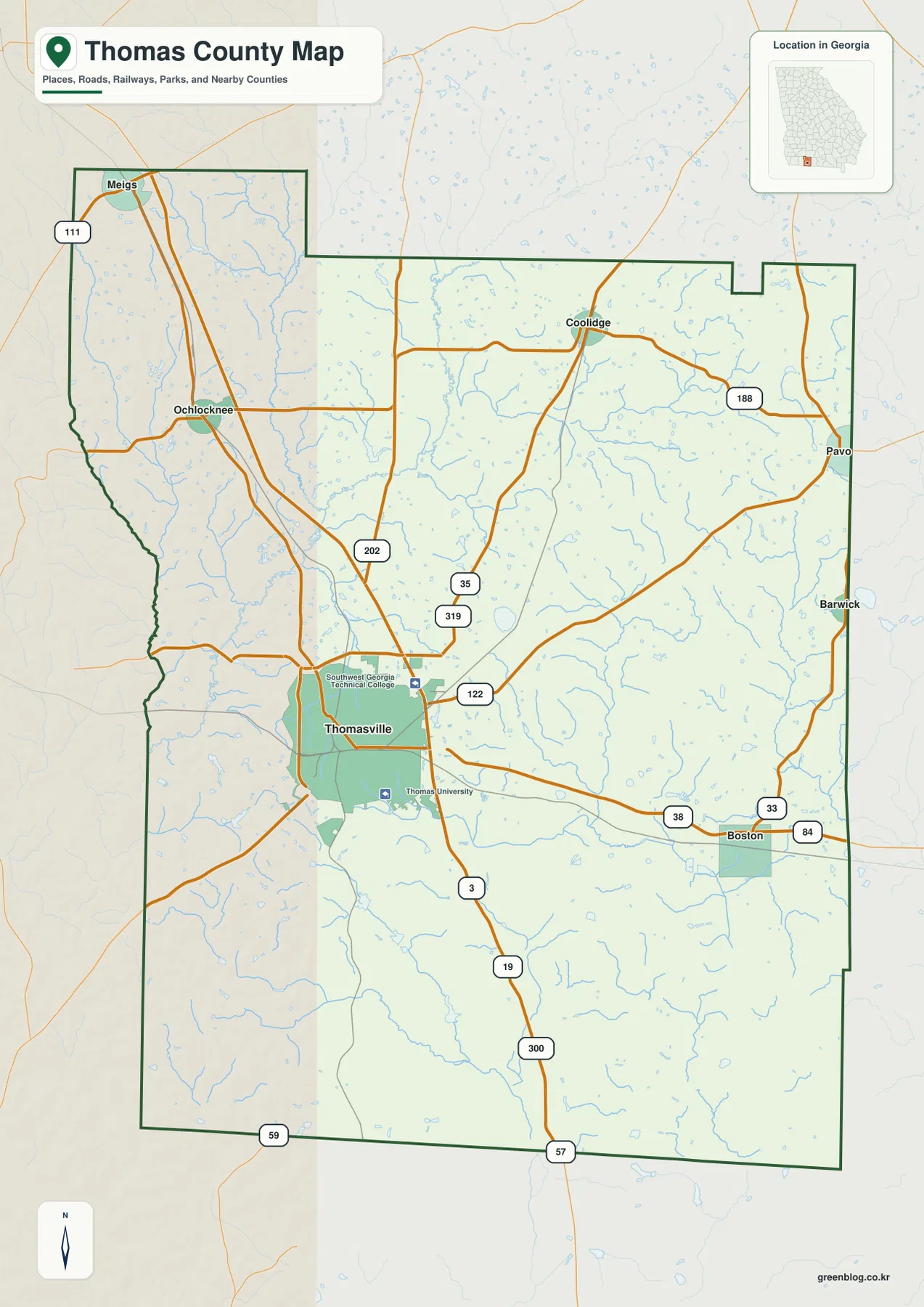
The county outline is distinctive as well. A northwestern projection contains Meigs, the northern boundary steps inward and outward, and the long eastern edge reaches past Pavo and Barwick. The western side is more irregular where the boundary bends beside the Ochlockonee area, while the southern edge forms the state-line side of the county. These changes in the outline matter when the map is used without city labels, because the shape itself helps distinguish Thomas County from neighboring counties in southwest Georgia.
Thomasville’s built-up area is more prominent than the smaller town footprints, and the map labels both Southwest Georgia Technical College and Thomas University near the city. That concentration of labels and roads contrasts with the broad rural spaces between Thomasville and the smaller communities. For a general location reference, the map works well for seeing where the county seat sits, which towns lie toward each edge, and how the main numbered roads connect those places. It should not be read as a parcel map or a complete inventory of local roads.
Four nearby towns compared from Thomasville
The city-connections map uses Thomasville as the hub and compares four selected towns by direct distance. Ochlocknee is shown at about 10 miles from Thomasville, Boston at about 12 miles, Coolidge at about 14 miles, and Meigs at about 17 miles. Those figures are straight-line distances, not driving distances along roads. They are most useful for quick geographic comparison: Ochlocknee is the closest of the four, while Meigs is the farthest in this selected group.
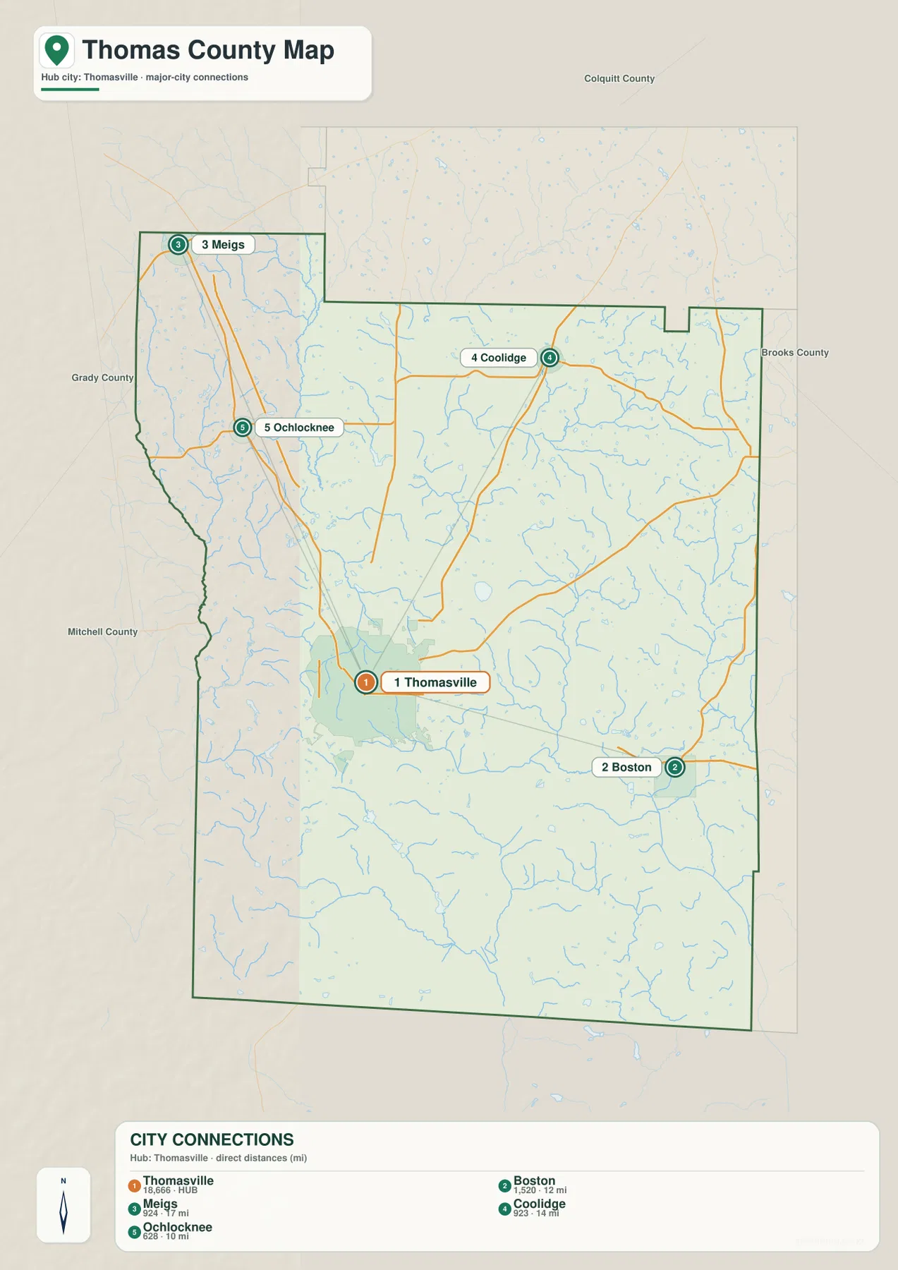
The directions are just as useful as the numbers. Ochlocknee lies northwest of Thomasville, with Meigs farther north in the county’s northwestern projection. Coolidge is northeast of the hub, while Boston lies to the east and slightly south. Pavo appears on the county reference map farther east but is not one of the four towns included in the connection legend, so the two maps emphasize slightly different sets of places. Comparing them prevents the city-connection graphic from being mistaken for a complete list of incorporated communities.
Neighboring-county labels provide a wider frame around the city pattern. Colquitt County is shown to the north, Brooks County to the east, Grady County to the west, and Mitchell County toward the west-southwest side. Meigs sits close to the northern and western county edges, Boston is closer to the Brooks County side, and Thomasville remains well inside the county rather than directly on one of those boundaries. That layout helps explain why Thomasville is a practical center for comparing the county’s smaller towns.
From the Ochlockonee system to the Aucilla side
The terrain-and-water map shifts attention away from roads and shows how thoroughly Thomas County is crossed by streams. The Ochlockonee River runs along the western side, with the Little Ochlockonee River descending through the northwestern part of the county. On the opposite side, the Aucilla River is labeled in the southeast. Big Creek is one of the stronger named tributaries in the northeast, while Pine Creek and Wards Creek help define the southern portion. Many smaller unnamed branches fill the spaces between those larger waterways.
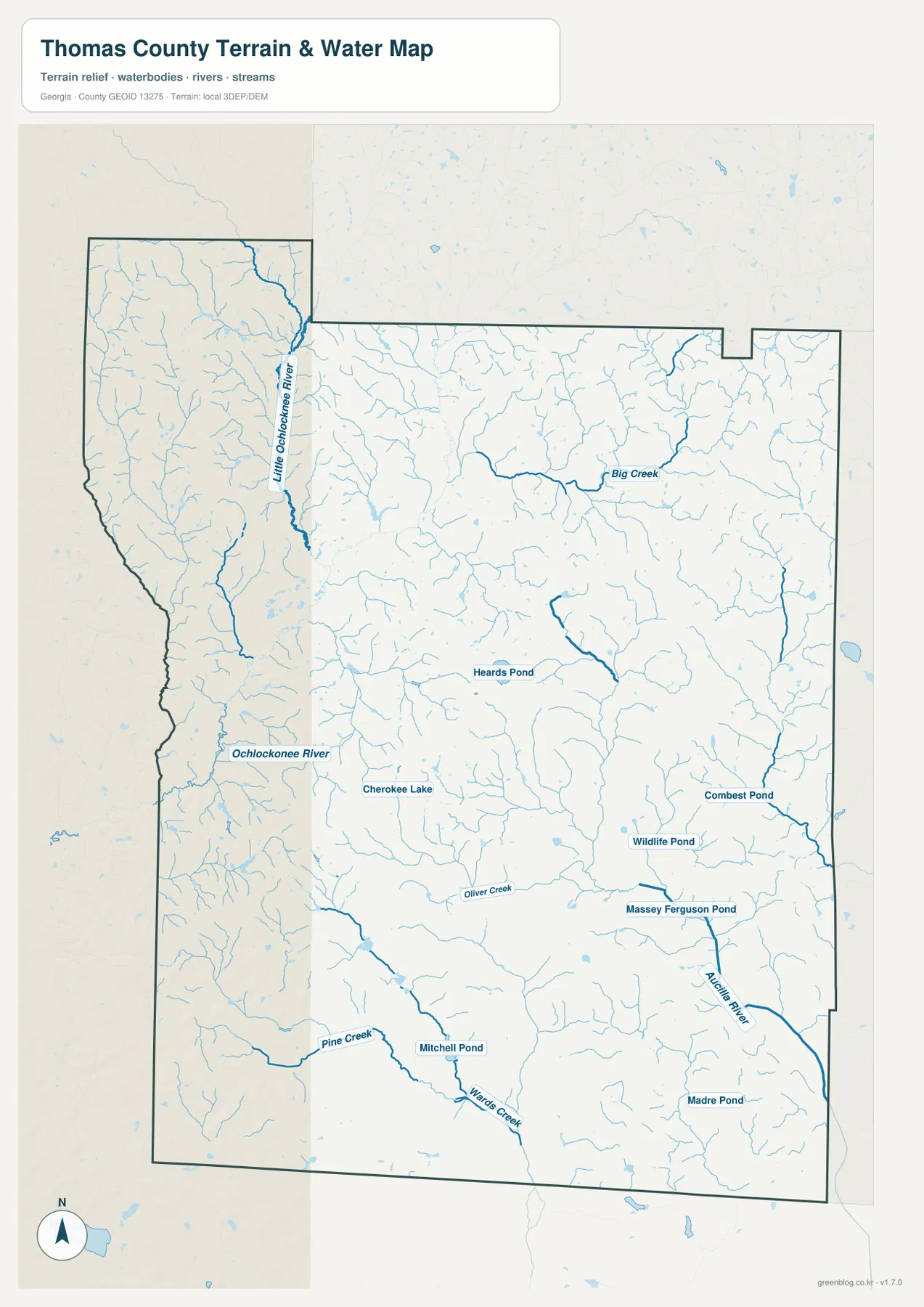
Several named ponds and lakes make the central and southern areas easier to locate. Cherokee Lake is shown near the Thomasville area, Heards Pond lies farther north, and Combest Pond and Wildlife Pond appear on the eastern side. Mitchell Pond and Massey Ferguson Pond are farther south, while Madre Pond sits near the southeastern part of the county. These names are useful as geographic reference points, but the map does not indicate public access, ownership, water depth, fishing conditions, or navigability.
This map should also not be treated as a flood-risk product. A stream line shows the location of a mapped watercourse, not the boundaries of a floodplain, and an area with fewer blue lines should not be assumed to be free of flood hazards. Its strongest use is comparative: it shows the two major river sides of the county, the smaller creeks feeding them, and the way those channels fit with the low valleys visible on the elevation map.
Elevation falls into the river and creek valleys
The elevation map lists an actual county range of about 25 to 106 meters, with a mean elevation of 64 meters. Browns and oranges are more common across the higher northern and northwestern terrain, while greens spread across lower southern and southeastern areas. Thomas County is not mountainous, but the roughly 80-meter difference across the county is enough to reveal a repeated pattern of gentle uplands separated by lower stream valleys.
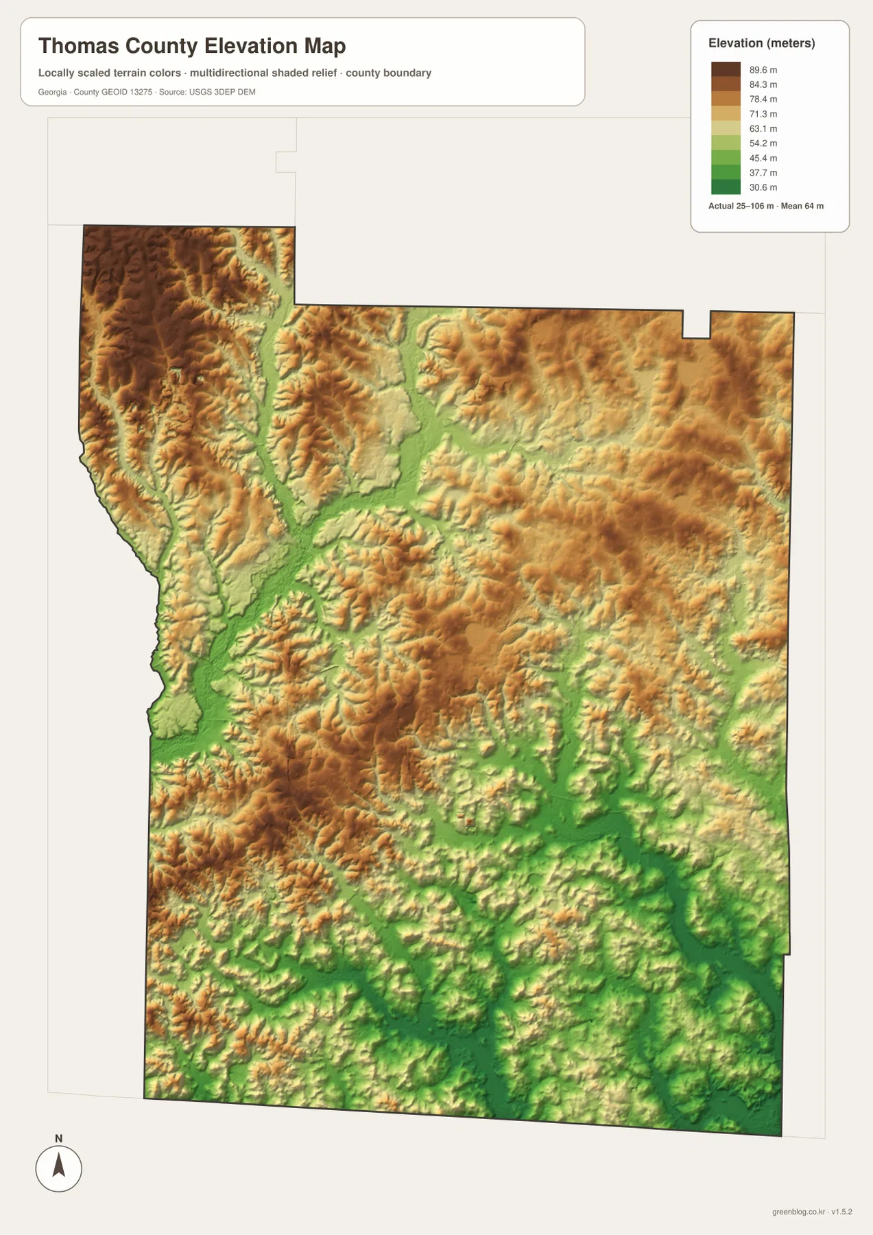
The relationship with the water map is especially clear along the Ochlockonee side. Green lowlands follow the western river corridor and extend inland along tributary valleys. Similar lower bands appear toward the Aucilla River in the southeast, while narrow green channels cut into higher ground through the middle and north. This does not mean every green area is wetland or every brown area is dry; the colors represent elevation, not land cover or flood status.
When the city map is used as a companion, the northern communities of Meigs and Coolidge fall in the general direction of more elevated terrain, whereas broad lower colors become more common south and southeast of Thomasville. The elevation graphic does not print city labels directly over the surface, so it should not be used to assign a precise elevation to a town or property. Its value is in showing the county-wide transition from higher rolling ground into lower river and creek valleys.
A southwest Georgia county on the Florida line
Thomas County was established in 1825, and Thomasville has remained the county seat and the dominant place name on the map. The county’s southern edge meets Florida, so the map has a different regional context from an interior Georgia county. Numbered routes continue south from Thomasville toward the state line, while other corridors spread east and north toward Boston, Pavo, Coolidge, Ochlocknee, and Meigs. The location makes it useful to consider both the internal county network and the broader north-south relationship with the Florida border.
The map set also shows why Thomas County cannot be summarized by Thomasville alone. Smaller incorporated places are distributed across the northern and eastern parts of the county, rivers and creeks occupy broad corridors between them, and elevation changes follow those drainage lines rather than city limits. For local-history orientation, classroom geography, or a county overview, this combination of settlement and physical geography is more informative than a boundary outline by itself.
Choose the map that matches the question
Use the county reference map when the main task is locating Thomasville, nearby towns, numbered roads, and the overall county outline. The city-connections map is better when you want a quick comparison of direction and straight-line distance from Thomasville to Ochlocknee, Boston, Coolidge, and Meigs. For named rivers, creeks, tributaries, lakes, and ponds, the terrain-and-water map removes much of the road emphasis and makes the drainage network easier to follow. The elevation map is the best choice for comparing the higher northern ground with lower stream valleys toward the south and southeast.
These maps can be combined in a report or presentation without forcing one graphic to answer every question. A county-location section may need only the first map, while a natural-geography section can pair the water and elevation maps. The city graphic works well for explaining relative position, but its mileage labels should never be described as driving distances. Likewise, the water and elevation maps are general references rather than flood, navigation, engineering, surveying, or parcel products.
Because the maps are stored as separate JPG files, you can choose only the view needed for a specific task instead of using a crowded all-in-one graphic. The road-and-boundary map is usually the clearest general reference, the city map is concise for relative location, and the water and elevation maps add physical-geography detail. The download does not change the intended limitations of the maps: higher image resolution does not turn them into survey-grade, flood-regulatory, or navigation products.
Frequently Asked Questions
Are the distances from Thomasville driving distances?
No. The city-connections map uses straight-line distances from Thomasville: about 10 miles to Ochlocknee, 12 to Boston, 14 to Coolidge, and 17 to Meigs. A road route will normally be longer because it follows the actual street and highway network.
Can the water map be used to identify flood-risk areas?
No. It shows mapped rivers, creeks, tributaries, and named ponds, including the Ochlockonee and Aucilla systems, but it does not show official flood zones. Flood-risk or insurance decisions require a separate authoritative flood map.
Is the 25–106 meter elevation range suitable for surveying?
No. The elevation map is a county-scale reference for comparing higher and lower terrain. It is useful for seeing broad uplands and river valleys, but it is not intended to provide engineering, construction, or parcel-level survey elevations.
Map File Information
The ZIP below contains the four original A3 high-resolution JPG maps shown as WebP previews on this page. Download the archive when you need larger files for printing, offline reference, document layout, or separate use of each map.
- File Type: one ZIP containing four A3 high-resolution JPG files
Related Maps
Sources and references
These external sources provide supporting county information and official data references. The road, town, water, and elevation descriptions above are based primarily on the four Thomas County maps supplied with this rewrite package.
- U.S. Census Bureau QuickFacts for Thomas County
- New Georgia Encyclopedia: Thomas County
- U.S. Census Bureau TIGER/Line boundary and road data
- USGS National Hydrography
- USGS 3D Elevation Program
Green Map creates custom-edited map images using open geographic data sources such as geoBoundaries, Natural Earth, OpenStreetMap, and government open data. These maps are edited visual materials, not raw data files, and are provided for education, documents, presentations, and graphic reference.