Montgomery County stretches from the Washington, D.C. edge to broad rural and stream-cut uplands in central Maryland. Rockville and Gaithersburg form the strongest central city pair, Takoma Park, Chevy Chase, and Kensington sit much closer to the metropolitan core, and Poolesville occupies a very different western setting near the Potomac River. Barnesville, Laytonsville, and Brookeville add smaller-town references farther north. This page explains the major roads, ranked cities, waterways, lakes, and elevation differences shown on the supplied maps, and matching high-resolution JPG files are available together in a downloadable ZIP archive.
Montgomery County Government describes Rockville as the county seat, and the County Council lists nineteen municipalities within the county. The supplied maps show only part of that municipal system, but they capture several of the most useful geographic contrasts: the I-270 corridor through Rockville and Gaithersburg, the denser southeastern edge near Washington, the Poolesville-Potomac side, and the higher northern uplands crossed by numerous stream valleys.
Table of Contents
Rockville and Gaithersburg anchor the I-270 corridor through the center of the county
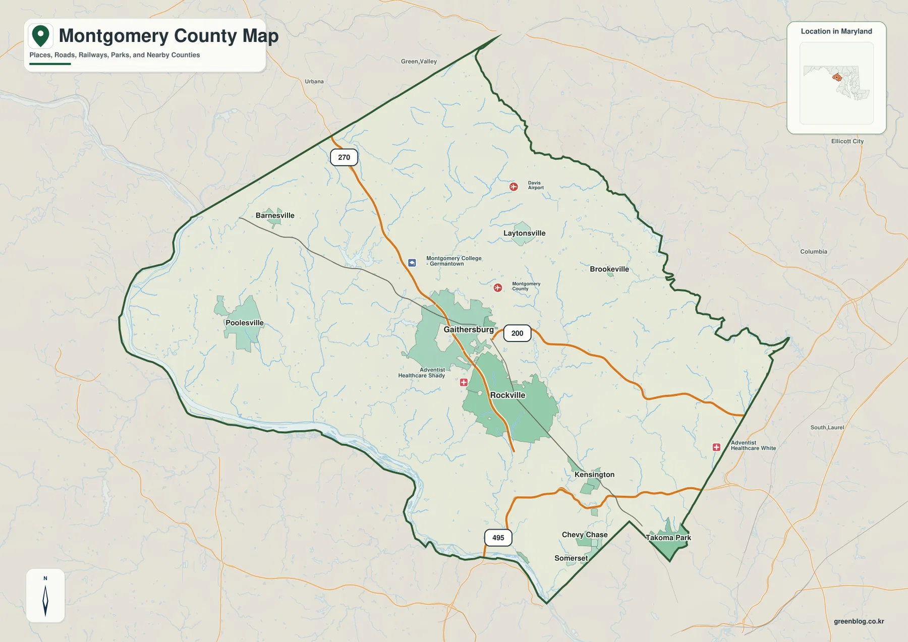
Rockville and Gaithersburg are the clearest places to begin on the general county map. They lie close together in the center, with I-270 continuing north toward the Frederick County side. South of Rockville, Kensington, Chevy Chase, Somerset, and Takoma Park occupy the more urbanized southeastern section, while the Montgomery College-Germantown label appears northwest of Gaithersburg.
MD 200 crosses eastward from the Gaithersburg area and provides a strong horizontal reference through the middle of the map. I-495 appears across the southern edge close to the Washington metropolitan area. Reading these roads by function keeps the map simple: I-270 is the main central north-south corridor, MD 200 crosses the central county, and I-495 defines part of the southern metropolitan connection.
Rockville is useful as both an administrative and geographic reference. Poolesville and the Potomac side lie well to the west, Brookeville and Laytonsville are farther north and east, and the Washington-facing communities are concentrated to the southeast. This makes Montgomery County much more varied than a single continuous suburban landscape.
The road map is intended for orientation rather than live navigation. Traffic, construction, incidents, and closures on I-270 and I-495 can change rapidly, so actual trips should be checked with current Maryland transportation information and a navigation service. The value of this map is in understanding which communities sit near the major corridors and how the central urban area relates to the wider county.
Poolesville and the Potomac side contrast sharply with the central and southeastern city belt
Poolesville occupies a broad western section near the Potomac River, far from the dense Rockville-Gaithersburg corridor. The western boundary bends with the river, and the surrounding map contains many small streams but relatively few large settlement labels. Montgomery County’s community page also contrasts places such as Poolesville with the busier downtown environments found elsewhere in the county.
Barnesville lies farther northwest, with Frederick County communities beyond the boundary. I-270 passes through the northern county but remains east of Poolesville, so straight-line proximity does not always translate into a direct road connection. The rural west is better understood as a landscape of valleys, farms, and smaller roads tied to the Potomac side.
Laytonsville and Brookeville mark the northeastern interior. Their surroundings show more small streams and rolling terrain than the heavily developed southeast. The county’s eastern boundary with Howard County is irregular, and the terrain becomes more dissected by stream valleys than the simple road network might suggest.
The southern county follows the Potomac River and approaches Washington, D.C., where I-495 becomes a major reference. Rockville, Kensington, Chevy Chase, and Takoma Park occupy a much denser setting than the Poolesville-Barnesville side. Dividing the map into a metropolitan southeast, central I-270 corridor, and rural west and north makes the county easier to read.
The City Index concentrates five ranked places in the central and southeastern county, with Poolesville alone in the west
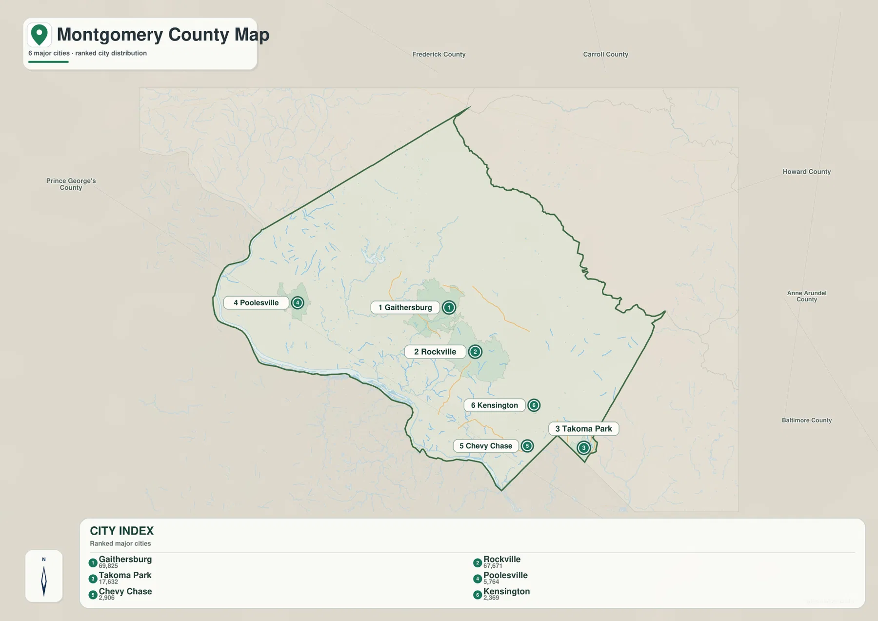
The City Index ranks Gaithersburg, Rockville, Takoma Park, Poolesville, Chevy Chase, and Kensington. It prints the values 69,825 for Gaithersburg, 67,671 for Rockville, 17,632 for Takoma Park, 5,764 for Poolesville, 2,906 for Chevy Chase, and 2,369 for Kensington. The graphic does not identify a reference year or statistical definition, so these figures should not be presented as current population counts. Current values should come from the latest U.S. Census Bureau or municipal data.
The positions are more useful than the ranking itself. Gaithersburg and Rockville are close together in the center, while Takoma Park, Chevy Chase, and Kensington sit near the southeastern edge. Poolesville is separated well to the west, making the difference between the metropolitan side and the rural Potomac side immediately visible.
This six-place index is not a complete list of Montgomery County municipalities. The County Council currently lists nineteen municipalities, including places such as Barnesville, Brookeville, Garrett Park, Glen Echo, Laytonsville, Somerset, and Washington Grove that do not appear among the six ranked markers. The graphic should therefore be read as a selected city distribution view rather than a municipal directory.
No connector lines or mileage labels are shown. The City Index cannot be used to calculate road distance from Gaithersburg to Poolesville or from Rockville to Takoma Park. It works well for a quick distribution view, while the full road map and current routing information are better for actual travel.
Great Seneca Creek and a chain of lakes organize the central and northern water network
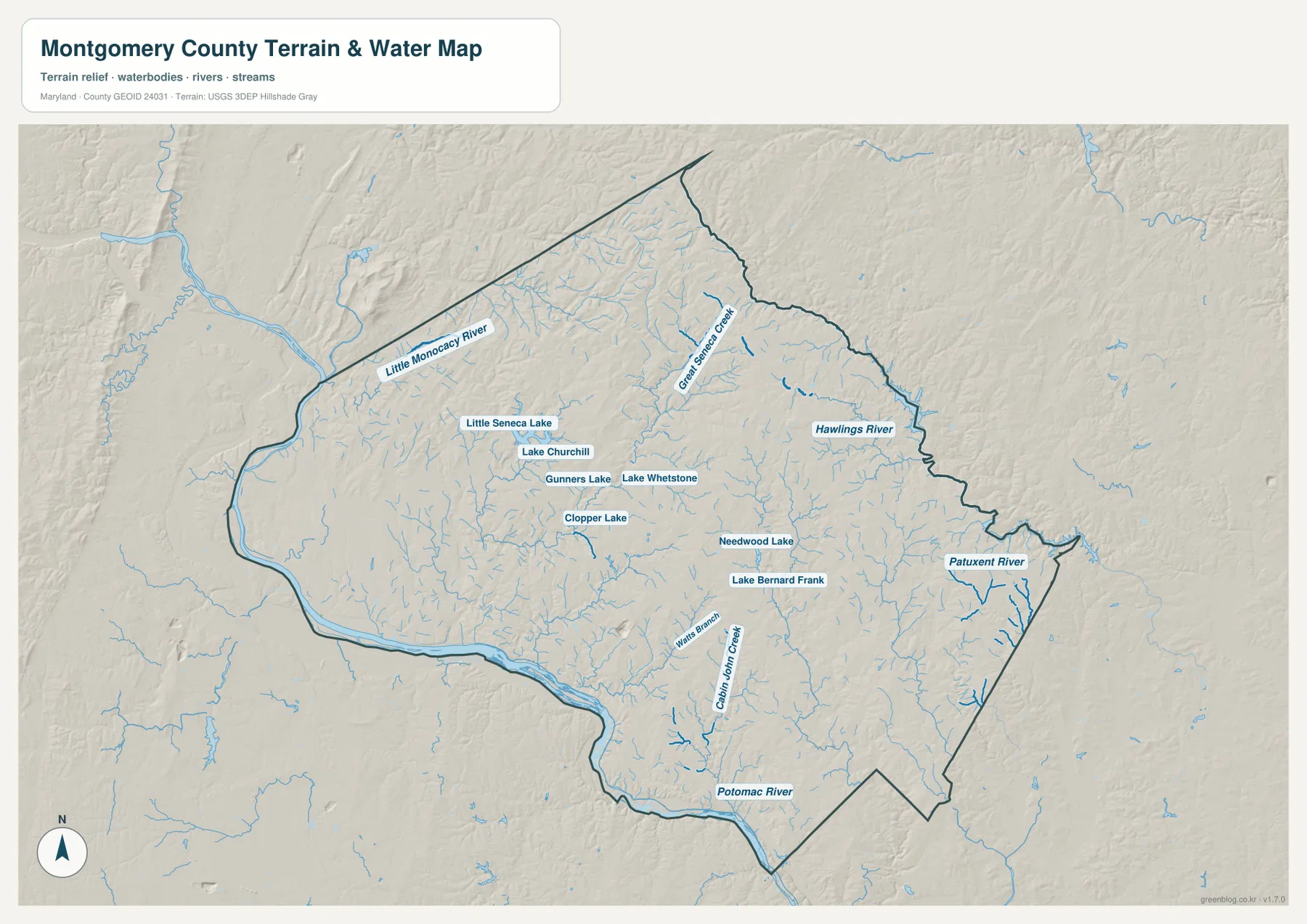
Potomac River is the largest boundary feature along the west and south. Little Monocacy River appears in the northwest, and countless smaller tributaries descend toward the Potomac through the western and central county. The terrain-water map shows that much of the land that looks continuous on the road map is actually divided by stream valleys.
Great Seneca Creek is one of the most prominent central-northern streams. Little Seneca Lake, Lake Churchill, Gunners Lake, Lake Whetstone, and Clopper Lake are clustered around the Gaithersburg-Germantown side. Montgomery County environmental information also identifies Great Seneca Creek Stream Valley Park in connection with watershed and stormwater management, providing a useful local example of how this drainage system passes through developed areas.
Needwood Lake and Lake Bernard Frank appear east and southeast of Rockville, while Watts Branch and Cabin John Creek continue toward the Potomac. These smaller waterways carve numerous green corridors through the southern urban area. Their density is easy to miss on a general road map but becomes obvious when the water layer is isolated.
Hawlings River and Patuxent River appear on the eastern side and drain away from the Potomac system. This separation helps explain why eastern Montgomery County has a different watershed structure from the western and southern county. The map is a geographic overview rather than a flood, water-quality, depth, or legal-boundary product; those uses require current USGS, FEMA, Maryland, or county information.
Higher northern uplands descend toward the Potomac River and its stream valleys
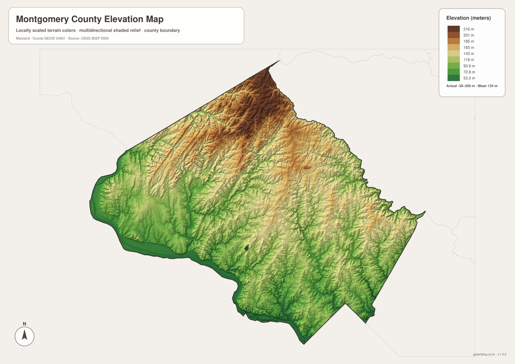
The elevation graphic reports an actual data range from -39 to 269 meters and a mean elevation of 124 meters. Those values describe the range in the supplied dataset and should not be treated as parcel-level survey elevations. The strongest visual pattern is a higher northern and north-central upland, with lower green terrain following the Potomac River along the west and south.
Ridges and stream-cut valleys are especially visible near the northern boundary and through the Barnesville-Laytonsville side. Great Seneca Creek and its tributaries form lower green corridors within that higher terrain. The relief is not mountainous, but the repeated differences between uplands and creek valleys are substantial enough to shape roads, parks, and drainage.
Rockville and Gaithersburg occupy middle elevations between the high northern terrain and the low Potomac corridor. Farther south, Cabin John Creek, Watts Branch, and other tributaries create narrow lower valleys through the metropolitan area. The western and southern boundary drops most clearly where the terrain meets the Potomac River.
The -39 to 269 meter range should not be used as the exact elevation of a building, road, or property. Engineering, surveying, drainage design, and flood-risk work require authoritative USGS elevation information, professional measurements, and current FEMA or local flood products. Elevation color alone cannot establish flood exposure.
Use the central road map for the city corridor and the water-elevation views for the wider county
The general county map is the best starting point for Rockville, Gaithersburg, Takoma Park, Poolesville, I-270, MD 200, and I-495. The City Index is cleaner when the goal is simply to compare six ranked places. For natural geography, the water map highlights Potomac River, Great Seneca Creek, Little Seneca Lake, Patuxent River, and the smaller tributaries, while the elevation map explains the transition from the higher north to the low Potomac corridor.
Montgomery County’s official community page describes a county with both busy downtown environments and quieter small-town or rural settings. The supplied map does not label every major community, but the contrast is still obvious between the Rockville-Gaithersburg and southeastern metropolitan areas and the Poolesville-Barnesville side. Water and elevation add another layer by showing how creek valleys divide both developed and rural terrain.
The downloadable originals are JPG files measuring 3638 × 2572 pixels each. They work well in landscape documents and can be enlarged around Rockville, Gaithersburg, Poolesville, Great Seneca Creek, or other areas for classroom material, presentations, and personal reference. Enlargement does not add live traffic, parcel boundaries, flood zones, water depth, or survey-grade elevation, so specialized decisions should always use current official data.
Frequently Asked Questions
What is the county seat of Montgomery County, Maryland?
Rockville is the county seat. Montgomery County Government identifies Rockville as the county seat, and the general map shows it near Gaithersburg in the central I-270 corridor.
Does the six-place City Index include every municipality in Montgomery County?
No. The index marks Gaithersburg, Rockville, Takoma Park, Poolesville, Chevy Chase, and Kensington, while the County Council lists nineteen municipalities. The City Index is therefore a selected distribution view rather than a complete municipal directory.
Can the -39 to 269 meter elevation range be used for surveying or flood decisions?
No. It is the overall range printed on the supplied elevation graphic and is useful only for broad geographic comparison. Precise property elevation should come from authoritative USGS or professional survey data, and flood decisions should rely on current FEMA and local flood information.
Map File Information
The ZIP archive contains high-resolution JPG maps of Montgomery County matching the map themes described on this page.
- Included Files: county and major roads map, City Index map, terrain and water map, elevation map
- Printable Size: 3638 × 2572 pixels each
- File Type: JPG
Related Maps
Sources and References
- Montgomery County Government – Community
- Montgomery County Council – County Information & Municipalities
- Montgomery County DEP – Great Seneca Creek Stream Valley Park
- U.S. Census Bureau – TIGER/Line Shapefiles
- USGS – National Hydrography
- USGS – 3D Elevation Program
Green Map creates custom-edited map images using open geographic data sources such as geoBoundaries, Natural Earth, OpenStreetMap, and government open data. These maps are edited visual materials, not raw data files, and are provided for education, documents, presentations, and graphic reference.