Dorchester County occupies a broad section of Maryland’s lower Eastern Shore, where the landscape changes from the Cambridge-Hurlock farming and town belt to some of the state’s lowest marsh and tidal country. Cambridge sits near the Choptank River in the northwest, while Church Creek, Taylors Island, Fishing Creek, and large wetland areas extend toward Chesapeake Bay and Tangier Sound. This page explains the county’s roads, ranked settlements, river systems, and elevation pattern using the supplied maps, and matching high-resolution JPG files are available together in a downloadable ZIP archive.
Dorchester County planning and annual-report material identifies Cambridge as the county seat and major social, cultural, and economic center. The county has nine incorporated municipalities: Brookview, Cambridge, Church Creek, East New Market, Eldorado, Galestown, Hurlock, Secretary, and Vienna. Several appear prominently on the maps, while the southern half contains fewer settlement labels and much more water, marsh, and fragmented shoreline.
Table of Contents
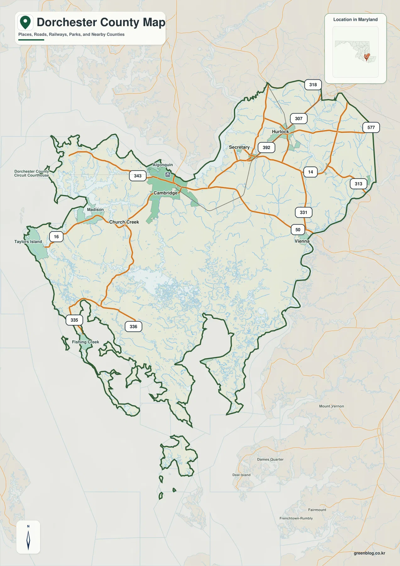
Cambridge and U.S. 50 provide the clearest entry point to the northern road network
Cambridge is the easiest place to begin on the general map. It lies near the Choptank River in the northwest, with U.S. 50 crossing the county from west to east. Secretary and East New Market sit farther east, and Hurlock is the strongest town label in the northeast. Compared with the southern marshes, this northern section has a more continuous road network and a denser pattern of settlements.
U.S. 50 continues east from Cambridge toward the Vienna side, while MD 331 provides another important north-south reference. Around Hurlock, MD 14, MD 307, MD 392, and MD 318 branch in different directions. MD 313 and MD 577 appear closer to the eastern boundary. Using Cambridge, Hurlock, and Vienna as anchors is much easier than trying to memorize every numbered road at once.
Secretary lies between the Cambridge and Hurlock areas, with East New Market nearby to the southeast. Small streams still cross the northern county, but the land remains much more continuous here than in the Blackwater and Transquaking lowlands farther south. The road pattern therefore looks more conventional in the north, even though waterways still influence many local routes.
This map does not provide live traffic, road closures, construction information, or current flooding conditions. Low-lying parts of Dorchester County can be sensitive to weather and water levels, so actual travel should be checked with Maryland transportation information and a current navigation service. The map is best used for understanding which settlements lie near the major highways and how the road network changes from north to south.
South of Church Creek, shoreline and marsh begin to matter more than the road grid
Southwest of Cambridge, Church Creek marks a useful transition into the lower county. MD 16 heads toward the Taylors Island side, where narrow pieces of land are separated by creeks, marshes, and Chesapeake water. The road network becomes less dense than it is around Cambridge and Hurlock, and shoreline shape becomes a much stronger part of the map.
MD 335 and MD 336 appear farther south, and Fishing Creek is one of the clearest settlement labels near the lower end of the county. Large wetland areas separate the southern communities, so two points that look close in a straight line may require a much longer road trip. Current routing information is therefore more important here than simple map distance.
Madison and Algonquin provide additional references west of Cambridge. MD 343 passes through the Algonquin side, while small bays and Choptank-connected water shape the nearby shoreline. This northwest coastal area mixes farms, settlements, and water more evenly than the deep southern marshes, creating a useful transition between Cambridge and the lower county.
The southern outline is best understood as a network of marshy peninsulas, islands, creeks, and open water rather than one continuous coast. Several county areas extend into narrow pieces of land, and islands appear inside the county boundary. This makes the lower half much more irregular than the comparatively simple northeastern boundary.
The City Index compresses six northern and central settlements into a clean distribution view
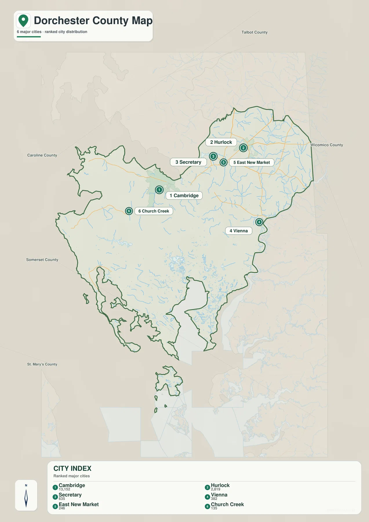
The City Index ranks Cambridge, Hurlock, Secretary, Vienna, East New Market, and Church Creek. It prints the values 13,152 for Cambridge, 2,819 for Hurlock, 635 for Secretary, 382 for Vienna, 246 for East New Market, and 135 for Church Creek. The graphic does not state a reference year or statistical definition, so those figures should not be presented as current population counts. Current figures should come from the latest U.S. Census Bureau data.
The locations are more useful than the ranking itself. Cambridge occupies the northwest, Hurlock lies in the northeast, and Secretary and East New Market cluster between them. Vienna is farther southeast, while Church Creek sits southwest of Cambridge near the transition into the southern marsh country.
The county’s official list contains nine incorporated municipalities, so the City Index is not complete. Brookview, Eldorado, and Galestown are not among the six ranked places. The graphic should therefore be read as a simplified settlement selection rather than a full municipal directory.
No connector lines or mileage labels appear between the ranked places. The graphic cannot be used to estimate driving distance from Cambridge to Hurlock, Vienna, or Church Creek. It works well for a quick settlement overview, while the full road map is the better choice for actual route context.
Choptank and Little Choptank rivers frame the northern waterfront
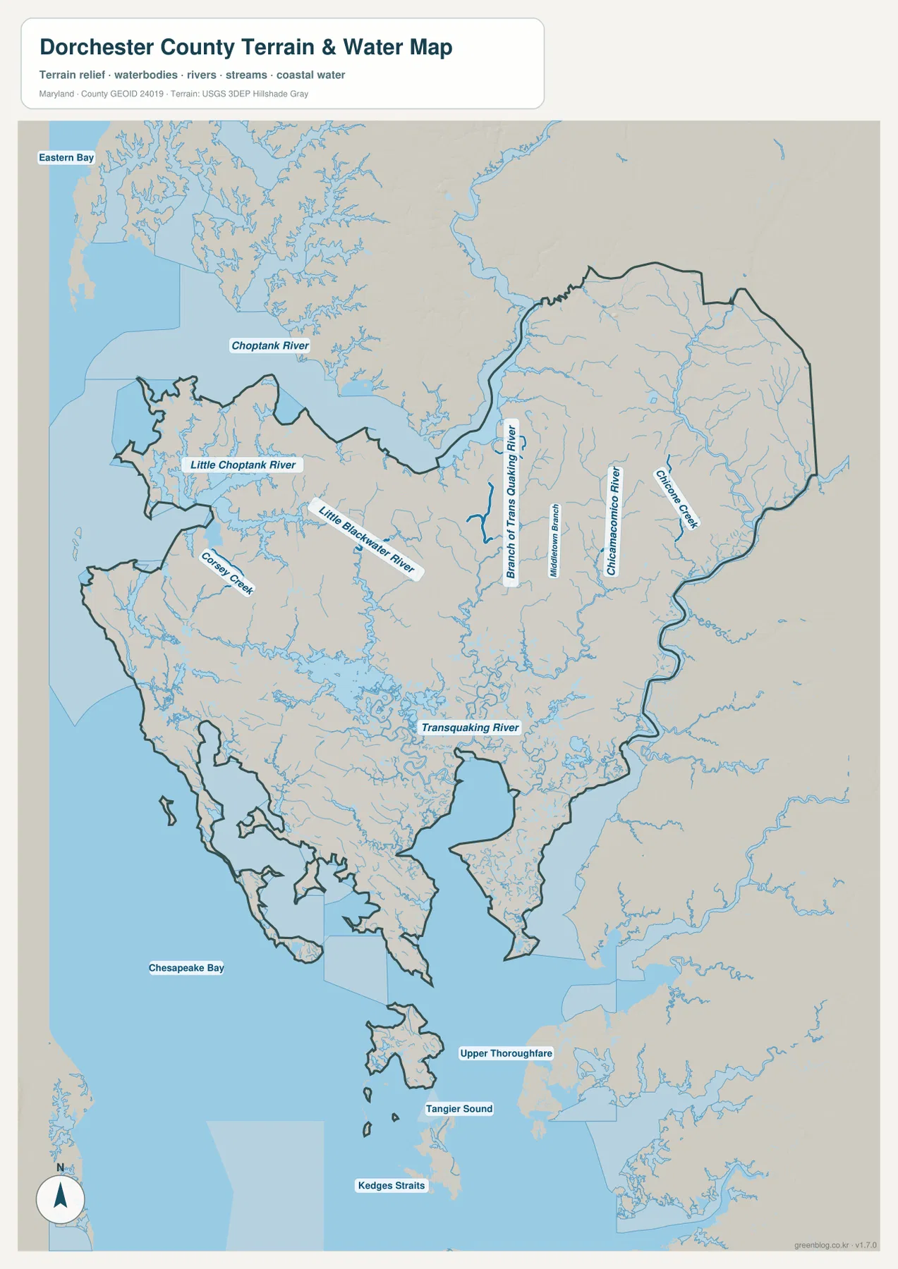
The Choptank River is the largest named water feature across the northern side of the terrain-water map. Cambridge sits near this river, while Eastern Bay and Chesapeake Bay open farther west. South of the Choptank, Little Choptank River forms its own broad estuary and branching shoreline, producing a complicated transition between upland farms and tidal marsh.
Coksey Creek is labeled south of the Little Choptank, and Little Blackwater River crosses the central county. Farther east, Branch of Transquaking River, Chicamacomico River, and Chicone Creek extend generally north to south. These waterways show how quickly the landscape becomes more dissected as the map moves away from the higher northeastern section.
Transquaking River becomes a major feature in the south-central county, surrounded by a dense maze of smaller channels and wetlands. The southern boundary opens toward Chesapeake Bay and Tangier Sound, with Upper Thoroughfare and Kedges Straits labeled farther down. Water becomes so dominant here that the county’s land shape is best understood through rivers and marshes rather than roads alone.
Blackwater National Wildlife Refuge lies about 12 miles south of Cambridge. The U.S. Fish & Wildlife Service describes its habitats as tidal marsh, forest, managed freshwater wetlands, and cropland. That official description provides useful real-world context for the broad low wetland area on the map. The county map is not a refuge visitor map, however, so trails, closures, and access rules should be checked on the refuge’s official site.
A mean elevation of 3 meters explains the county’s broad lowland character
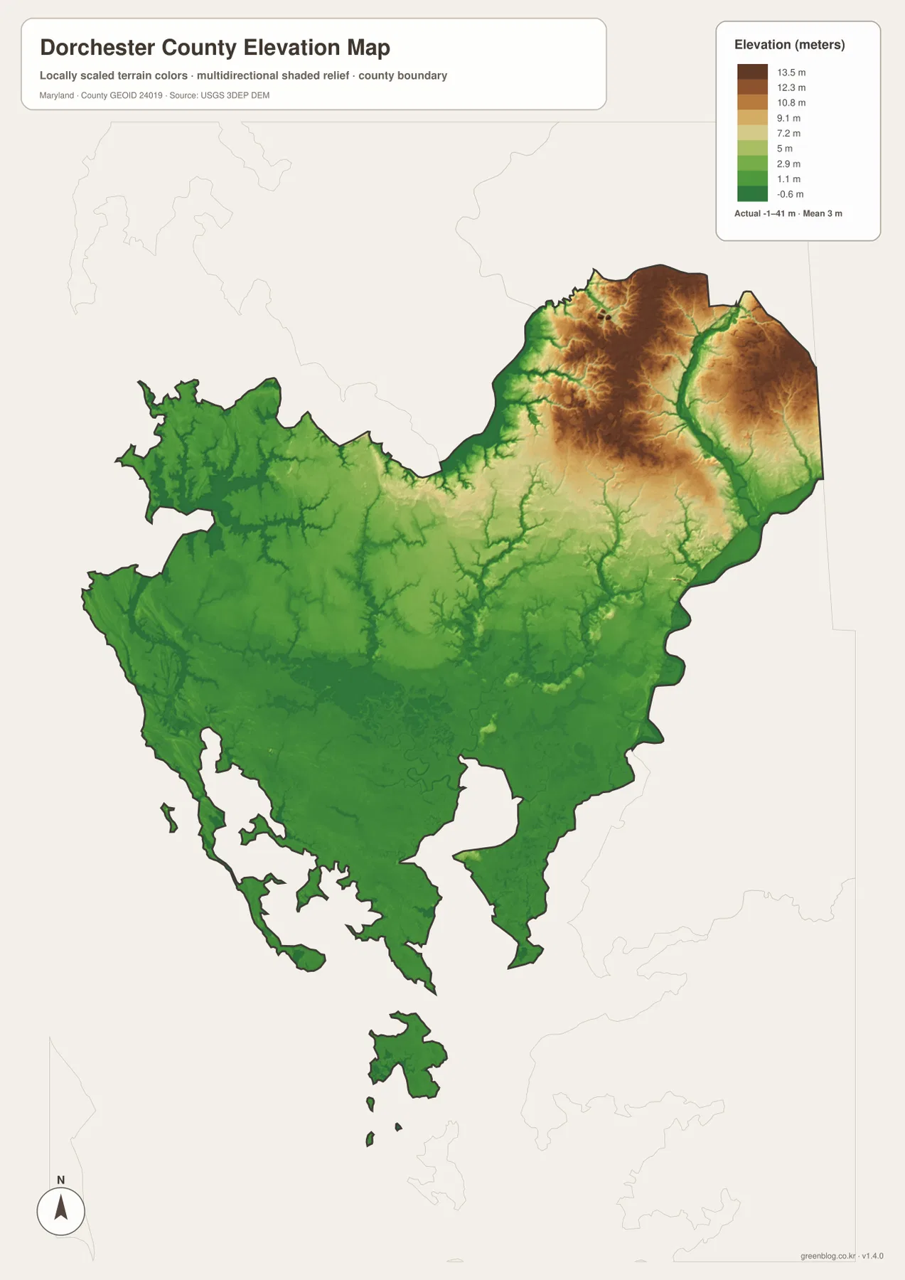
The elevation graphic reports an actual data range from -1 to 41 meters and a mean elevation of only 3 meters. Most of Dorchester County is therefore extremely low. Large areas of the south and west appear in dark green, especially around Chesapeake Bay, Little Choptank River, Blackwater, and the Transquaking drainage.
The relatively higher tan and brown terrain is concentrated in the northeast around the Hurlock, Secretary, and East New Market side. It is still low in an absolute sense, but the contrast with the southern marsh country is obvious. Small tributaries cut green corridors into these higher areas as they descend toward the Choptank and Nanticoke-side drainage systems.
Cambridge sits below the highest northeastern terrain, and the landscape drops further toward Church Creek, Taylors Island, and the lower county. The water and elevation maps reinforce one another: the places with the densest tidal channels and marshes are also among the lowest broad areas on the map.
The -1 to 41 meter range is useful for countywide comparison, not property-level surveying. In a place where a few meters can matter, construction, drainage, elevation certificates, and flood-risk decisions require detailed USGS elevation data, professional survey information, and current FEMA or local flood products.
Use the road map for Cambridge and the water-elevation views for the lower county
The general county map is the best starting point for Cambridge, Hurlock, Vienna, U.S. 50, MD 16, MD 331, and the other main roads. The City Index is cleaner when the goal is simply to compare six ranked settlements. For natural geography, the terrain-water map makes the Choptank, Little Blackwater, Transquaking, and Tangier Sound relationships clear, while the elevation map explains why so much of the lower county is dominated by marsh and low ground.
Blackwater National Wildlife Refuge is an especially useful local reference for understanding southern Dorchester County. Federal information places it about 12 miles south of Cambridge and describes more than 20,000 acres open for public recreation in a landscape dominated by marsh, forest, shallow water, and wetland habitat. Current refuge roads, closures, and visitor rules should be checked separately, while the county maps here provide broader geographic context.
The downloadable originals are JPG files measuring 2572 × 3638 pixels each. They can be used in full-page documents or enlarged around Cambridge, Hurlock, Blackwater, Taylors Island, or Fishing Creek for classroom material, presentations, and personal reference. Enlargement does not add live road conditions, parcel boundaries, flood zones, nautical depth, or survey-grade elevation, so specialized decisions should always use current official data.
Frequently Asked Questions
What is the county seat of Dorchester County, Maryland?
Cambridge is the county seat. Dorchester County planning material describes it as the county’s social, cultural, and economic hub, and the general map shows it near U.S. 50 and the Choptank River in the northwest.
Does the six-place City Index include every incorporated municipality in Dorchester County?
No. The index marks Cambridge, Hurlock, Secretary, Vienna, East New Market, and Church Creek, while official county material also lists Brookview, Eldorado, and Galestown. The City Index is therefore a simplified settlement view rather than a complete municipal list.
Can the -1 to 41 meter elevation range be used for surveying or flood decisions?
No. It is the broad dataset range printed on the supplied elevation graphic. Precise property elevation should come from authoritative USGS or professional survey data, and flood decisions should rely on current FEMA and local flood information.
Map File Information
The ZIP archive contains high-resolution JPG maps of Dorchester County matching the map themes described on this page.
- Included Files: county and major roads map, City Index map, terrain and water map, elevation map
- Printable Size: 2572 × 3638 pixels each
- File Type: JPG
Related Maps
Sources and References
- Dorchester County, Maryland – Official Website
- Dorchester County FY2024 Annual Report
- U.S. Fish & Wildlife Service – Blackwater National Wildlife Refuge
- U.S. Census Bureau – TIGER/Line Shapefiles
- USGS – National Hydrography
- USGS – 3D Elevation Program
Green Map creates custom-edited map images using open geographic data sources such as geoBoundaries, Natural Earth, OpenStreetMap, and government open data. These maps are edited visual materials, not raw data files, and are provided for education, documents, presentations, and graphic reference.