Frederick County stretches from the central Monocacy River valley to the higher Catoctin and South Mountain country in western and northern Maryland. Frederick city forms the main central hub, while Middletown and Myersville sit closer to the western ridges, Thurmont and Emmitsburg extend toward the Pennsylvania line, and Brunswick occupies the Potomac side in the southwest. The maps on this page explain the major roads, settlement distribution, rivers and reservoirs, and sharp elevation changes across the county. Matching high-resolution JPG files are also available together in a downloadable ZIP archive.
Frederick County’s official municipal page identifies Frederick as the county seat and lists twelve incorporated municipalities: Brunswick, Burkittsville, Emmitsburg, Frederick, Middletown, Mount Airy, Myersville, New Market, Rosemont, Thurmont, Walkersville, and Woodsboro. The general map also labels communities such as Ballenger Creek and Green Valley. Reading those places against the Monocacy lowlands and the western mountain belts makes the county’s road and water patterns much easier to understand.
Table of Contents
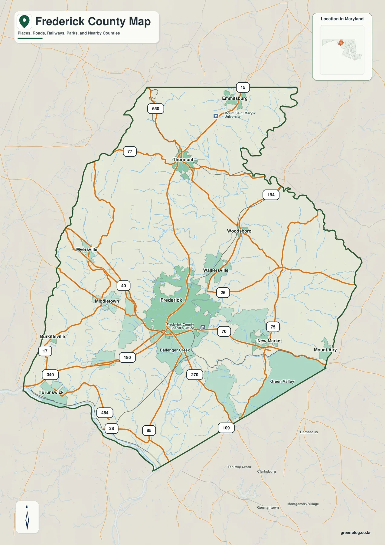
Frederick and the I-70–I-270 junction organize the central road network
Frederick is the clearest starting point on the general county map. I-70 crosses east to west, I-270 heads south toward Montgomery County and the Washington region, and U.S. 15 runs north toward Thurmont and Emmitsburg. U.S. 40 provides another strong east-west reference toward the Middletown side. Once these major corridors are located, the rest of the county can be divided into manageable northern, western, eastern, and southern sections.
Walkersville sits just north of Frederick, with Woodsboro farther to the northeast. New Market and Mount Airy occupy the eastern side, where MD 26 and MD 75 help locate the communities relative to Frederick. Mount Airy straddles the Frederick–Carroll county line, so its position at the far eastern edge reflects an actual jurisdictional feature rather than simply a map-label placement.
Ballenger Creek appears south of Frederick around the I-270 corridor, with MD 85 and U.S. 180 adding local road references. Farther southeast, Green Valley and the Mount Airy side connect with MD 75 and MD 109. To the southwest, U.S. 340 and MD 17 lead toward Brunswick. The central network radiates in several directions, which is why Frederick works so well as the anchor for the entire county.
The map is designed for countywide orientation, not live navigation. Construction, congestion, winter weather, and closures can change conditions on I-70, I-270, U.S. 15, U.S. 40, and U.S. 340. Actual travel should be checked with current Maryland transportation information and a navigation service, while this map is best used to understand relative position and the major regional corridors.
Middletown, Myersville, and Thurmont reveal how the western ridges reshape the road pattern
West of Frederick, U.S. 40 reaches Middletown and the terrain becomes much more strongly influenced by ridges and valleys. Myersville sits farther northwest near the mountain belt. MD 17 provides an important road reference through the Burkittsville-Brunswick side, while MD 77 and MD 550 become useful around Thurmont in the north.
Thurmont sits along U.S. 15 and near MD 77, making it the clearest northern mountain-side anchor. Emmitsburg lies farther north near the Pennsylvania line, and Mount St. Mary’s University is labeled nearby. The gaps between settlements become wider than they are around Frederick, and roads more often follow valleys or mountain edges rather than a dense suburban grid.
Frederick County’s own municipal information describes Myersville as a community near the Catoctin Mountains and the Appalachian Trail. That setting helps explain why the western road network looks different from the broad Monocacy valley around Frederick. U.S. 40, MD 17, and MD 77 make more sense when compared with the elevation and water maps, where the ridge-and-valley terrain becomes unmistakable.
Brunswick occupies the southwestern Potomac side, reached from the county interior by U.S. 340 and MD 17. The transition from the high northwest to the central urban corridor and then to the Potomac lowlands gives Frederick County several distinct geographic zones within one boundary.
The City Index spreads six ranked places across the center, mountains, east, and Potomac side
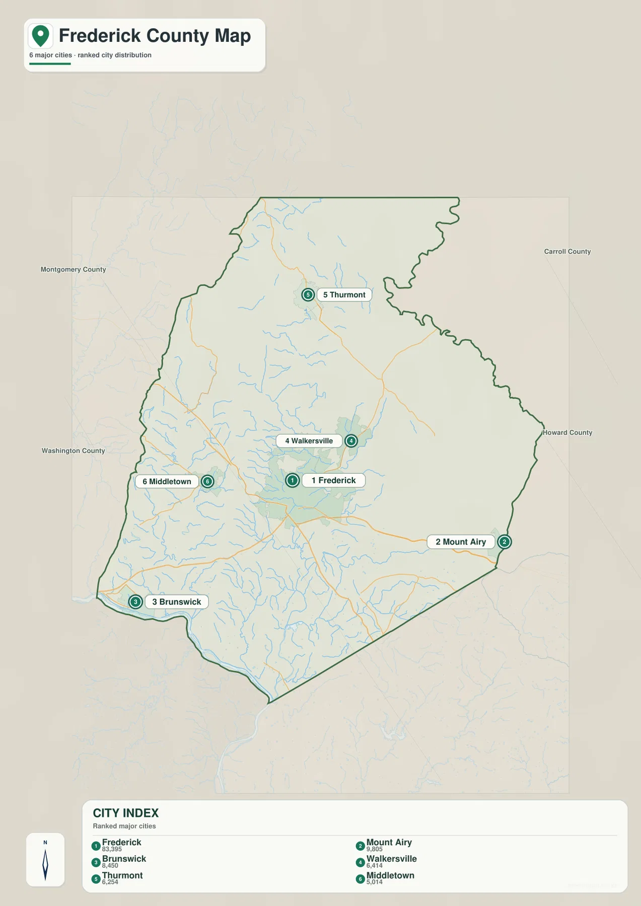
The City Index ranks Frederick, Mount Airy, Brunswick, Walkersville, Thurmont, and Middletown. It prints the values 83,395 for Frederick, 9,805 for Mount Airy, 8,450 for Brunswick, 6,414 for Walkersville, 6,254 for Thurmont, and 5,014 for Middletown. The graphic does not state a reference year or statistical definition, so these figures should not be presented as current population counts. Current values should come from the latest U.S. Census Bureau or Frederick County population data.
The location pattern is more useful than the ranking itself. Frederick is central, Mount Airy sits on the eastern edge, Brunswick is in the southwest, Middletown is west of Frederick, and Walkersville and Thurmont occupy the northern half. Even this simplified view shows that the county’s larger communities are distributed across several very different landscapes.
The official county municipal list contains six additional incorporated places not shown in the ranked index: Burkittsville, Emmitsburg, Myersville, New Market, Rosemont, and Woodsboro. Mount Airy also straddles the line between Frederick and Carroll counties. The City Index is therefore a selected ranked-place map rather than a complete directory of municipal government.
No connector lines or mileage values are shown between the six places. The graphic should not be used to estimate driving distance from Frederick to Brunswick, Thurmont, or Mount Airy. It works best for quick settlement distribution, with the full road map and current routing information used when actual travel is the question.
Monocacy River collects streams from both the mountain side and the eastern uplands
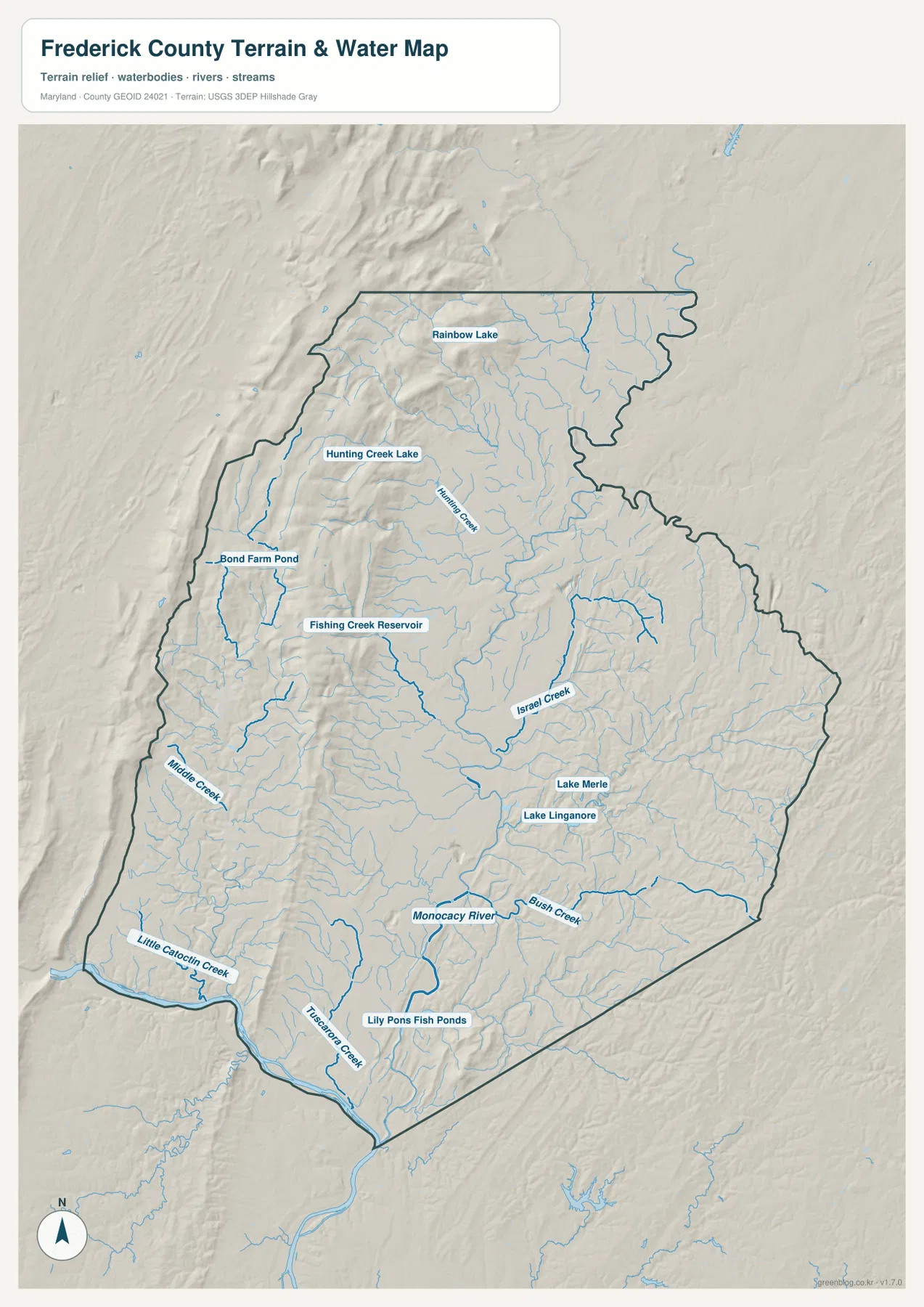
Monocacy River is the dominant water feature through the central and southern county. Streams from Frederick and the surrounding uplands drain toward it before the river continues to the Potomac. Frederick County’s stream program organizes the county into five major watershed areas: Catoctin Creek, Double Pipe Creek, Potomac River, Lower Monocacy River, and Upper Monocacy River. That official framework helps make sense of the many smaller creek names shown on the map.
In the north, Hunting Creek and Hunting Creek Lake are clearly labeled, along with Rainbow Lake. Fishing Creek Reservoir lies farther south between the Thurmont side and Frederick. Israel Creek runs through the central-eastern county, while Lake Linganore and Lake Merle provide strong water landmarks nearby. Bush Creek appears farther southeast and joins the broader Monocacy drainage.
The western and southwestern map contains Kiddie Creek, Little Catoctin Creek, and Tuscarora Creek, along with smaller water bodies such as Bond Farm Pond and Lily Pons Fish Ponds. Little Catoctin Creek is especially useful near the Brunswick-Potomac side because it shows how water descends from the western uplands toward the major river corridor.
Frederick County’s Sustainable Monocacy Commission publishes Monocacy and watershed maps, and the county Stream Survey monitors local waterways across its watershed system. The terrain-water map here is a geographic overview rather than a flood, water-quality, legal-boundary, or engineering product. Flood safety and site-specific decisions should use current FEMA, USGS, Maryland, and county information.
The elevation map makes the western mountain belts and central Monocacy valley unmistakable
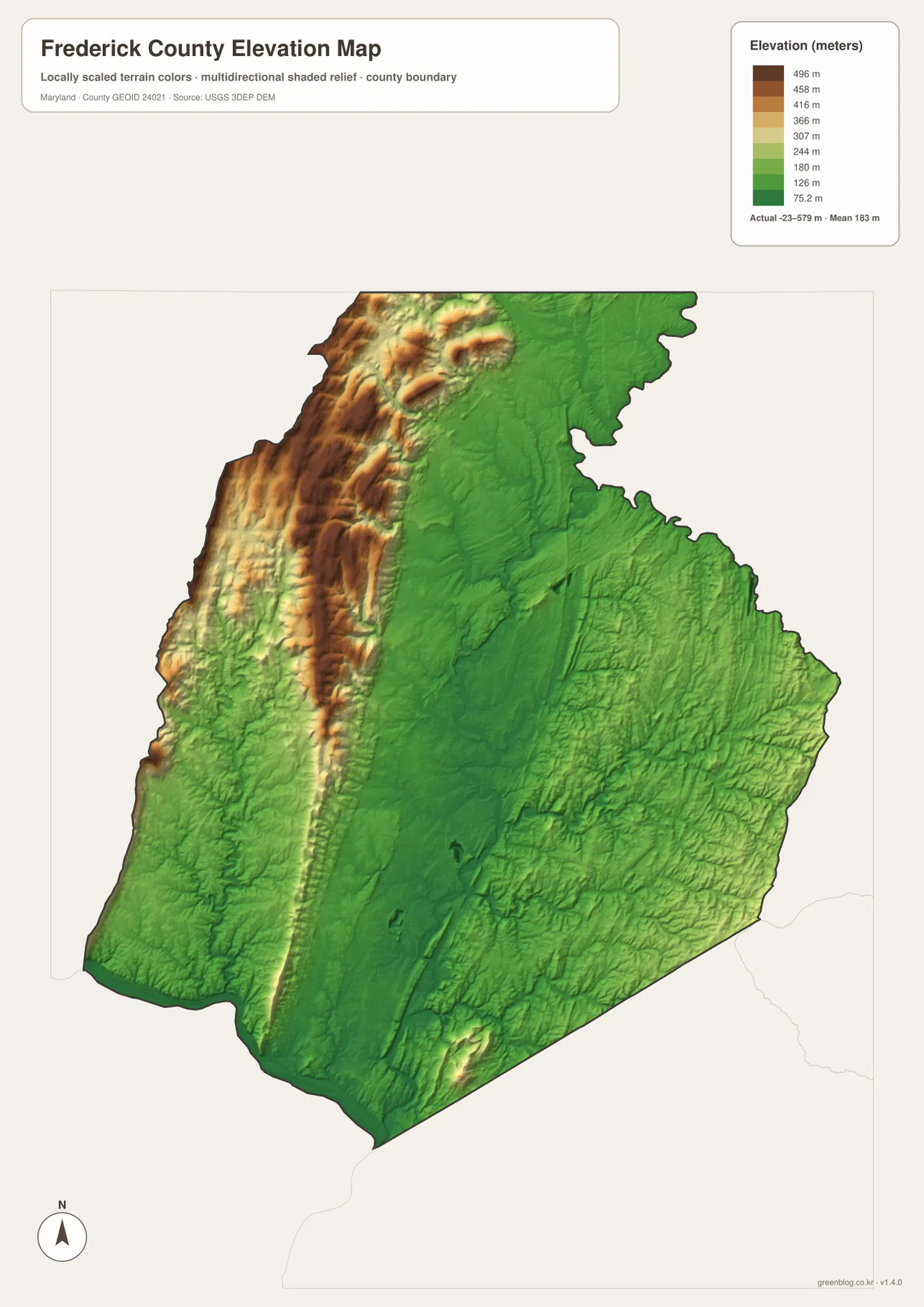
The elevation legend prints an actual data range from -23 to 579 meters and a mean of 183 meters. That range belongs to the map’s elevation dataset and should not be treated as a parcel-level survey. Visually, the most important pattern is clear: high brown and tan terrain dominates the west and northwest, while a broad green lowland follows the central Monocacy valley.
South Mountain rises west of the Middletown-Myersville side, while another mountain belt associated with Catoctin Mountain extends north toward Thurmont. Frederick County watershed material describes the Catoctin Creek valley as lying between Catoctin Mountain on the east and South Mountain on the west. That relationship is easy to recognize on the elevation map because the lower valley is enclosed by higher ridges.
Frederick and Walkersville occupy much lower, broader terrain than the western mountains. New Market and the Mount Airy side become more rolling again, although they do not reach the strongest western elevations on this rendering. The Potomac side around Brunswick is also low, reinforcing the relationship between major rivers and the lower parts of the county landscape.
The elevation layer is intended for regional comparison. The -23 to 579 meter range should not be applied to a particular road, house, or parcel without authoritative data. Surveying, engineering, drainage design, and flood assessment require detailed USGS elevation products, professional survey measurements, and dedicated flood maps where appropriate.
Use the central road map for cities and highways, then switch to water and elevation for the mountain side
The general county map is the best starting point for Frederick, Walkersville, New Market, Brunswick, I-70, I-270, U.S. 15, and U.S. 340. The City Index is cleaner when the goal is simply to compare six ranked places. For natural geography, the water map shows Monocacy River, Israel Creek, Little Catoctin Creek, Fishing Creek Reservoir, and other waterways, while the elevation map explains the sharp difference between the western mountains and the broad central valley.
Frederick County’s watershed program notes that all of the county’s main watersheds eventually drain to the Potomac River and then onward toward Chesapeake Bay and the Atlantic. That larger connection helps tie together landscapes that look separate on the road map: Thurmont’s mountain streams, Frederick’s Monocacy corridor, and Brunswick’s Potomac setting are parts of one regional drainage system.
The downloadable originals are JPG files measuring 2572 × 3638 pixels each. They work well in full-page documents and can be enlarged around Frederick, Thurmont, Middletown, Brunswick, or other areas for classroom material, presentations, and personal reference. Enlargement does not add live traffic, parcel boundaries, flood zones, or survey-grade elevation, so specialized decisions should always use current official data.
Frequently Asked Questions
What is the county seat of Frederick County, Maryland?
Frederick is the county seat. Frederick County’s official municipal information identifies it as the county seat, and the general map shows it at the central junction of I-70, I-270, and U.S. 15.
Does the six-place City Index include every incorporated municipality in Frederick County?
No. The index marks Frederick, Mount Airy, Brunswick, Walkersville, Thurmont, and Middletown, while the county’s official municipal list also includes Burkittsville, Emmitsburg, Myersville, New Market, Rosemont, and Woodsboro. The City Index is a simplified ranked-place view, not a complete municipal directory.
Can the -23 to 579 meter elevation range be used as a property survey?
No. It is the overall data range printed on the supplied elevation graphic and is useful only for broad geographic comparison. Property-level elevation should come from authoritative USGS or professional survey data, and flood decisions should rely on current FEMA and local flood information.
Map File Information
The ZIP archive contains high-resolution JPG maps of Frederick County matching the map themes described on this page.
- Included Files: county and major roads map, City Index map, terrain and water map, elevation map
- Printable Size: 2572 × 3638 pixels each
- File Type: JPG
Related Maps
Sources and References
- Frederick County – Municipalities & Cities
- Frederick County – Sustainable Monocacy Commission
- Frederick County – Stream Survey
- U.S. Census Bureau – TIGER/Line Shapefiles
- USGS – National Hydrography
- USGS – 3D Elevation Program
Green Map creates custom-edited map images using open geographic data sources such as geoBoundaries, Natural Earth, OpenStreetMap, and government open data. These maps are edited visual materials, not raw data files, and are provided for education, documents, presentations, and graphic reference.