Charles County occupies a large part of Southern Maryland between the Washington-area suburbs and the broad Potomac waterfront. Waldorf and La Plata form the most visible north-central population area, Indian Head extends toward the northwestern river side, Port Tobacco lies west of La Plata, and the county narrows southward to Cobb Island. Roads, creeks, tidal rivers, and low rolling uplands all shape the county differently from one section to another. This page explains those features using the supplied maps, and matching high-resolution JPG files are available together in a downloadable ZIP archive.
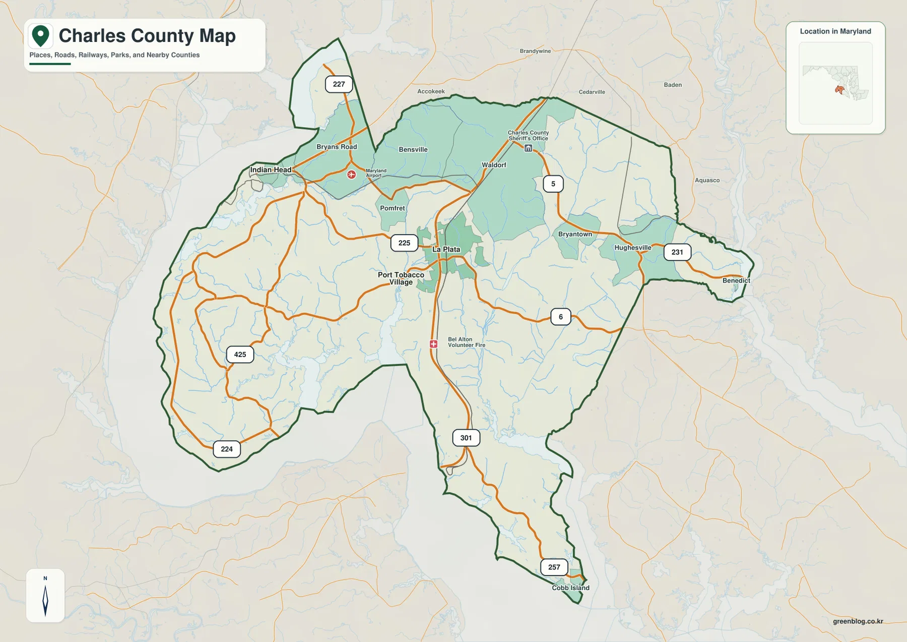
Charles County’s official comprehensive plan identifies La Plata as the county seat and lists three incorporated towns: La Plata, Indian Head, and Port Tobacco. The general map also labels larger and smaller communities such as Waldorf, Bryans Road, Bensville, Pomfret, Bryantown, Hughesville, Benedict, and Cobb Island. Reading those place names alongside the incorporated towns helps separate administrative status from the broader settlement pattern that people use to navigate the county.
Table of Contents
Waldorf and La Plata provide the easiest frame for the north-central road network
Waldorf is one of the strongest place labels on the general county map, and La Plata sits southwest of it near the middle of Charles County. MD 5 is a major north-south reference through the Waldorf side, while U.S. 301 and MD 225 and 6 converge around La Plata. Starting with these two places makes it easier to follow the county toward Indian Head and Port Tobacco in the west, Bryantown and Hughesville in the east, and Cobb Island in the far south.
La Plata is both the county seat and a practical road anchor. Port Tobacco Village lies just to the west, Pomfret and Bensville are to the northwest, and Bryantown and Hughesville extend eastward. The pattern shows that Charles County is not organized around a single continuous city. Instead, several communities are separated by rural areas, streams, and state highways.
Northwest of Waldorf, Bryans Road and Indian Head occupy land close to the Potomac side. MD 227 appears near the northern edge, while MD 225 provides a clear connection between the Indian Head side and La Plata. This part of the county has a different feel from inland Waldorf because broad water, tidal creeks, and irregular shorelines become much more important to the map.
East of La Plata, Bryantown and Hughesville lead toward Benedict, where MD 231 provides a strong road reference. MD 6 and U.S. 301 continue south through the county, and MD 257 becomes important near Cobb Island. Rather than reading every road at once, it is simpler to use Waldorf and La Plata as the center, then follow one direction at a time.
Indian Head and Port Tobacco shift the map toward the Potomac-facing west
The western side of Charles County is defined as much by water as by roads. Indian Head lies near Mattawoman Creek and the Potomac, with MD 225 providing the clearest road connection toward La Plata. Farther south, Port Tobacco Village sits close to Port Tobacco River. Roads become more curved through this side of the county because they cross or work around creek valleys, wetlands, and irregular shorelines.
MD 224 and MD 425 are useful references for the broad western and southwestern rural area. MD 425 runs through the western interior, while MD 224 follows parts of the Potomac-facing side. Settlement labels are less concentrated here than around Waldorf, but the water network is denser, so natural features often provide better orientation than town names.
Mallows Bay Park provides a useful real-world example of the western Potomac shore. Charles County’s official park page places it in Nanjemoy and describes shallow-water access to the Potomac River, a boat ramp, kayak opportunities, fishing, hiking, and the historic “Ghost Fleet.” The name is not a dominant label on the supplied county map, but the park gives concrete context for the MD 224–425 side of Charles County.
Road distance can be longer than the apparent straight-line separation in this creek-cut landscape. The map is not a live navigation product and does not show construction, traffic, closures, or current travel time. For a trip through the western county, use the map for geographic orientation and verify the actual route with current Maryland transportation information and a navigation service.
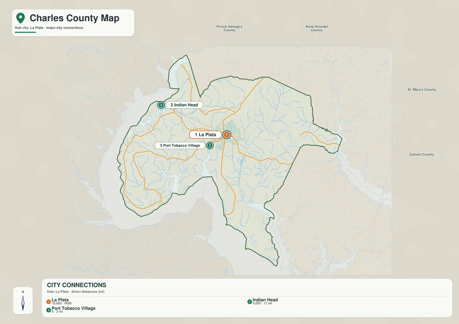
The La Plata hub map gives straight-line distances to Indian Head and Port Tobacco Village
The City Connections graphic uses La Plata as the hub and links it to Indian Head and Port Tobacco Village. The lower index prints the figures 10,683 for La Plata, 4,055 for Indian Head, and 4 for Port Tobacco Village. Because the image does not state a reference year or statistical definition for those values, they should not be presented as current population counts. Up-to-date population information should come from the latest U.S. Census Bureau data.
The distance labels are explicitly described as direct distances. Indian Head is shown 11 miles from La Plata and Port Tobacco Village 3 miles away. These are straight-line measurements, not driving mileage. Actual travel follows MD 225 and other roads, so both road distance and travel time can differ from the numbers printed on the graphic.
The three markers make the western county relationship easy to see. La Plata is central, Indian Head is northwest, and Port Tobacco Village is nearby to the west. Waldorf, Cobb Island, and other important communities do not appear on this simplified map, so it should be paired with the general county view when the goal is a complete settlement picture.
The City Connections map is most useful for a presentation or quick location comparison. It removes most local road detail and leaves the hub relationship clear. When actual driving routes matter, the general map and current navigation data are the better tools.
Mattawoman Creek and Port Tobacco River define the low western valleys
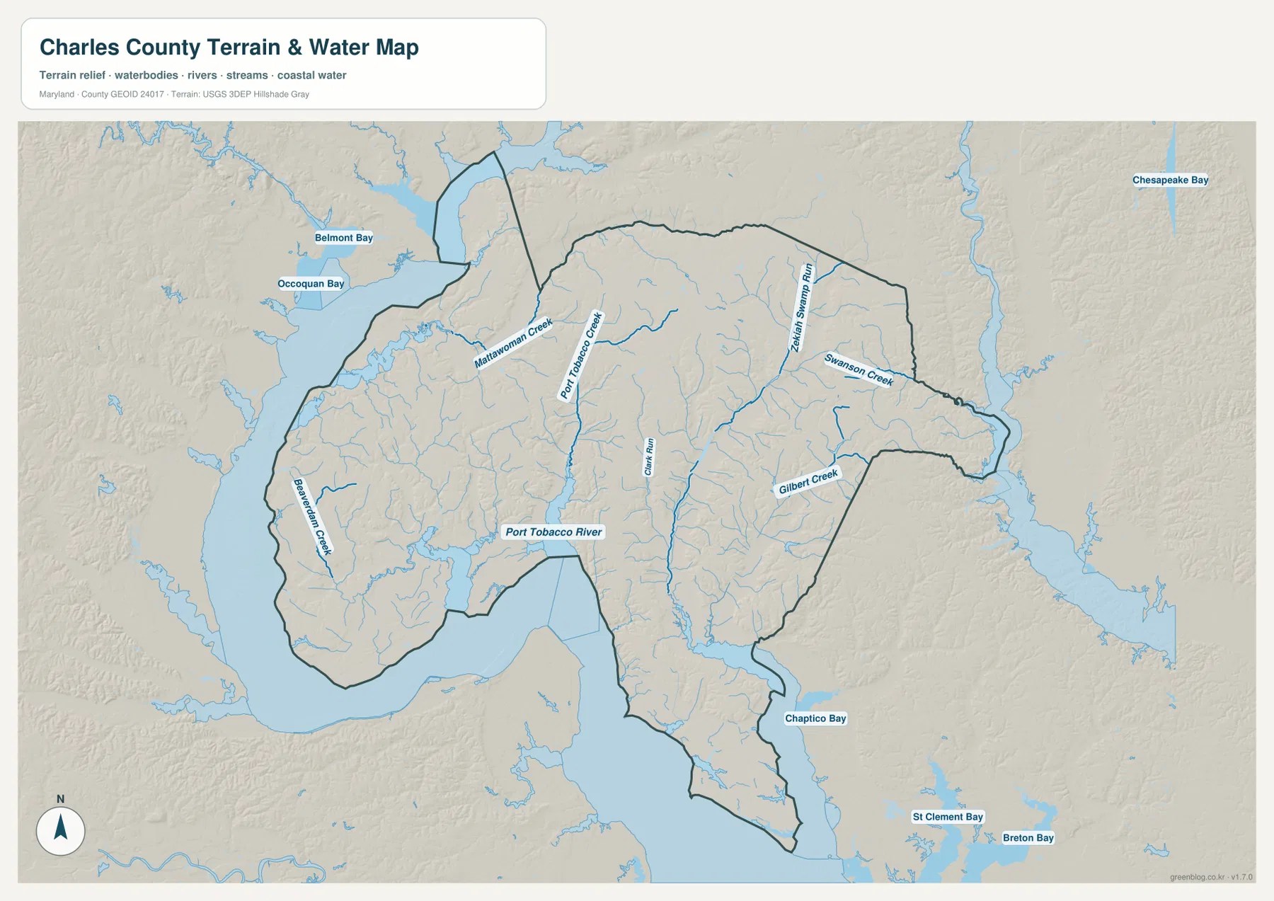
Mattawoman Creek is one of the clearest water labels in the northwest. It reaches broad water close to Indian Head and Bryans Road, while Occoquan Bay and Belmont Bay are labeled beyond the county to the north. South of Mattawoman Creek, Port Tobacco Creek descends toward Port Tobacco River, creating another broad low-water corridor on the western side.
Beaverdam Creek runs through the western interior, and Clark Run provides a central north-south water reference. These waterways are smaller than the Potomac-side rivers and bays, but they divide the interior into numerous low valleys. The terrain-water map makes this especially clear in areas that look comparatively empty on the road map.
The eastern half has a different drainage pattern. Zekiah Swamp Run extends for a long distance north to south, with Swanson Creek farther east and Gilbert Creek near the southeastern boundary. These labels help orient the rural land east of the Waldorf-La Plata area and show that streams are widespread across the county rather than confined to the Potomac shoreline.
Chaptico Bay appears south of the county in the St. Mary’s County direction, while the broad western and southern water connects with the Potomac River. This map is not a nautical chart, flood map, or legal water-boundary product. Depth, tides, navigation channels, real-time levels, and flood probability should be checked with current NOAA, FEMA, USGS, Maryland, or local information.
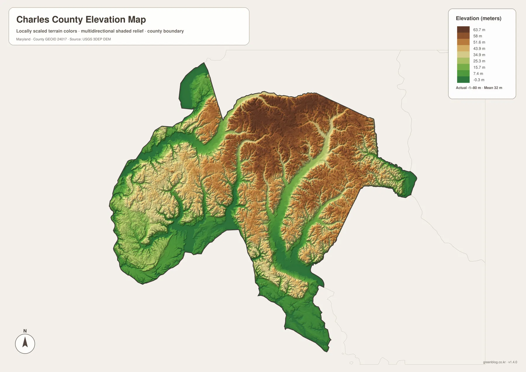
Elevation is higher on inland ridges and lower along the Potomac and major creek valleys
The elevation map prints an actual data range from -1 to 80 meters and a mean elevation of 32 meters. Charles County is not mountainous, but the shaded relief shows a clear difference between the higher inland ridges and the green lowlands beside major creeks and tidal water. The county is therefore better described as gently rolling and valley-cut than uniformly flat.
The Waldorf and Bryantown side contains broad areas of relatively higher tan and brown terrain. Zekiah Swamp Run forms a long lower green corridor through the eastern interior. Mattawoman Creek in the northwest and the Port Tobacco system in the west also occupy low ground, so the water and elevation maps reinforce one another.
The southern stretch toward Cobb Island and the Potomac is generally lower, with broad green areas around shorelines and small tributaries. Higher ridges reappear through parts of the north-central and eastern interior. The pattern is not a single slope across the county; instead, modest uplands are repeatedly separated by creek valleys.
The -1 to 80 meter range is the overall dataset range printed on the supplied elevation image, not a property survey. It should not be used to determine the exact elevation of a building, road, or parcel, or to make engineering and flood-risk decisions. Those uses require authoritative USGS elevation data, professional surveying, and dedicated FEMA or local flood products.
Choose the map by whether you need the Waldorf road network or the Potomac-side landscape
The general county map is the best starting point for Waldorf, La Plata, Indian Head, Cobb Island, U.S. 301, MD 5, MD 6, and MD 225. The City Connections view is cleaner when the question is simply how La Plata relates to Indian Head and Port Tobacco Village by straight-line distance. For natural geography, the water map highlights Mattawoman Creek, Port Tobacco River, and Zekiah Swamp Run, while the elevation map explains why those waterways occupy broad low corridors.
Mallows Bay Park adds useful local context to the Potomac-facing west. Charles County describes the site as a recreation area with shallow-water access, kayaking, fishing, hiking, and the historic Ghost Fleet. The park is useful for understanding the character of the western shoreline, although current access, hours, and recreation rules should always be checked on the official county page before a visit.
The downloadable originals are JPG files measuring 3638 × 2572 pixels each. Their landscape orientation works well for full-page documents and for enlarging areas such as Waldorf, La Plata, Indian Head, or Port Tobacco in classroom material, presentations, and personal reference. Enlarging the files does not add live traffic, parcel boundaries, flood zones, nautical depth, or survey-grade elevation, so specialized decisions should always use current official data.
Frequently Asked Questions
What is the county seat of Charles County, Maryland?
La Plata is the county seat. Charles County’s comprehensive plan identifies La Plata as the county seat, and the general map shows it as a central road reference around U.S. 301 and several state highways.
Are the 11 miles to Indian Head and 3 miles to Port Tobacco Village driving distances from La Plata?
No. The City Connections graphic labels them as direct distances, meaning straight-line measurements. Actual driving follows MD 225 and other local roads, so road mileage and travel time can be different.
Can the -1 to 80 meter elevation range be used for surveying or flood decisions?
No. It is the overall data range printed on the supplied elevation graphic and is useful only for broad geographic comparison. Precise elevation should come from authoritative USGS or professional survey data, and flood decisions should rely on current FEMA and local flood information.
Map File Information
The ZIP archive contains high-resolution JPG maps of Charles County matching the map themes described on this page.
- Included Files: county and major roads map, City Connections map, terrain and water map, elevation map
- Printable Size: 3638 × 2572 pixels each
- File Type: JPG
Related Maps
Sources and References
- Charles County Comprehensive Plan – Background
- Charles County – Mallows Bay Park
- U.S. Census Bureau – TIGER/Line Shapefiles
- USGS – National Hydrography
- USGS – 3D Elevation Program
Green Map creates custom-edited map images using open geographic data sources such as geoBoundaries, Natural Earth, OpenStreetMap, and government open data. These maps are edited visual materials, not raw data files, and are provided for education, documents, presentations, and graphic reference.