If you are looking for a map of Fayette County, Alabama, the easiest place to begin is the city of Fayette near the center of the county. Several major roads meet there, while Berry lies to the east, Belk to the west, and Glen Allen near the northern boundary. This page includes four complementary views of the county—general roads and places, city connections, waterways, and elevation—and you can download all four as high-resolution A3 JPG files in one ZIP package. The maps are useful for printing, classroom work, local orientation, and closer study of the county’s roads, rivers, and terrain.
Table of Contents
Fayette County at a Glance
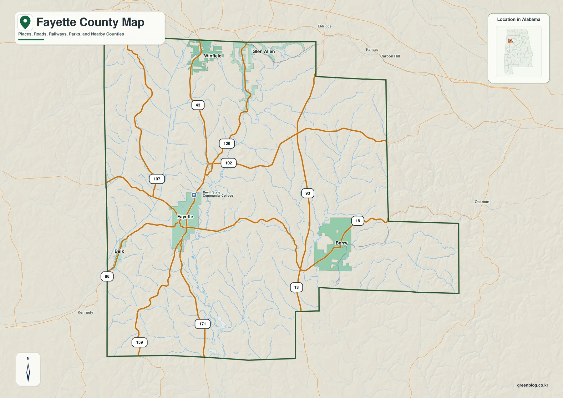
Fayette County sits in northwestern Alabama, with Fayette serving as the county seat and the clearest geographic reference point on the map. The county boundary is not a simple rectangle: it has a broad central body, an eastern extension around the Berry side, and a northern edge that approaches Marion County. Looking at the boundary together with roads and streams makes the county’s shape much easier to understand than reading a list of communities by itself.
Fayette is where the transportation pattern comes together. U.S. 43 runs north and south through the county seat, Alabama 18 provides an important east-west connection, and Alabama 171 continues south. Alabama 129 leads toward Glen Allen and the northern part of the county, while Alabama 96 reaches west toward Belk. These routes create several distinct travel directions from Fayette rather than one long urban corridor.
The surrounding places are smaller and more dispersed. Berry is positioned on the eastern side, Belk is west of Fayette, and Glen Allen is close to the Marion County line. Nearby names outside or near the county boundary can also appear on a regional map, so the county outline is important when deciding whether a label marks a Fayette County municipality or simply provides orientation beyond the boundary.
Roads Radiating from Fayette
U.S. 43 is the most obvious north-south reference line on the county map. It passes through Fayette and continues toward the northern edge, helping you keep the western and eastern halves of the county in perspective. Alabama 18 crosses the central area and runs toward Berry, making it the most useful route for reading the county from west to east.
South of Fayette, Alabama 171 provides another clear directional route. To the west, Alabama 96 connects the Belk side, while Alabama 129 turns north toward Glen Allen. Smaller state and local roads fill in the spaces between those larger routes. On the map, the result is a road network that resembles several branches meeting near the county seat rather than a grid covering the whole county evenly.
This arrangement is useful for practical orientation. Someone locating a place near Berry can first find Alabama 18 and move east from Fayette. For the Belk side, Alabama 96 is a better reference. Glen Allen is easier to place by following the northern roads and checking the Marion County boundary. The map therefore works best when Fayette is treated as a starting point and the surrounding places are read by direction and road connection.
How Fayette, Berry, Belk, and Glen Allen Relate
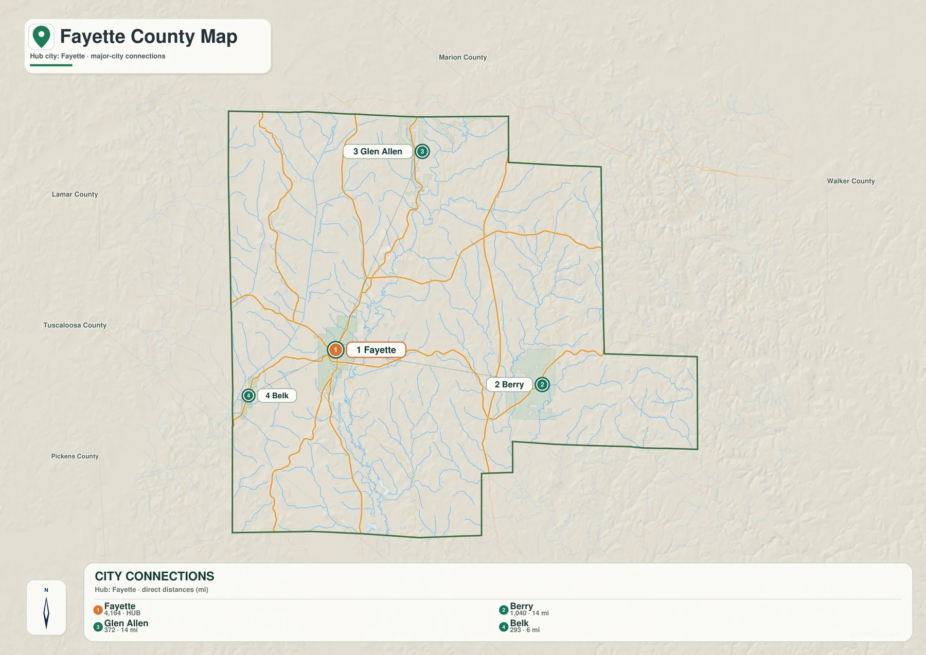
The city-connection map removes much of the background detail and focuses attention on the four incorporated communities shown for Fayette County. Fayette appears near the center, Glen Allen to the north, Berry to the east, and Belk to the west. That simplified view is useful when the main question is not which creek or minor road is nearby, but how the communities are positioned relative to one another.
It also shows why Fayette remains the best anchor for reading the county. The other municipalities occupy separate edges or corridors, while Fayette sits near the meeting point of the most important routes. The pattern is rural and spread out. There is no continuous built-up strip linking all four places, so the distance and direction between communities matter more than a single shared urban area.
Sipsey River, Tributaries, and Lakes
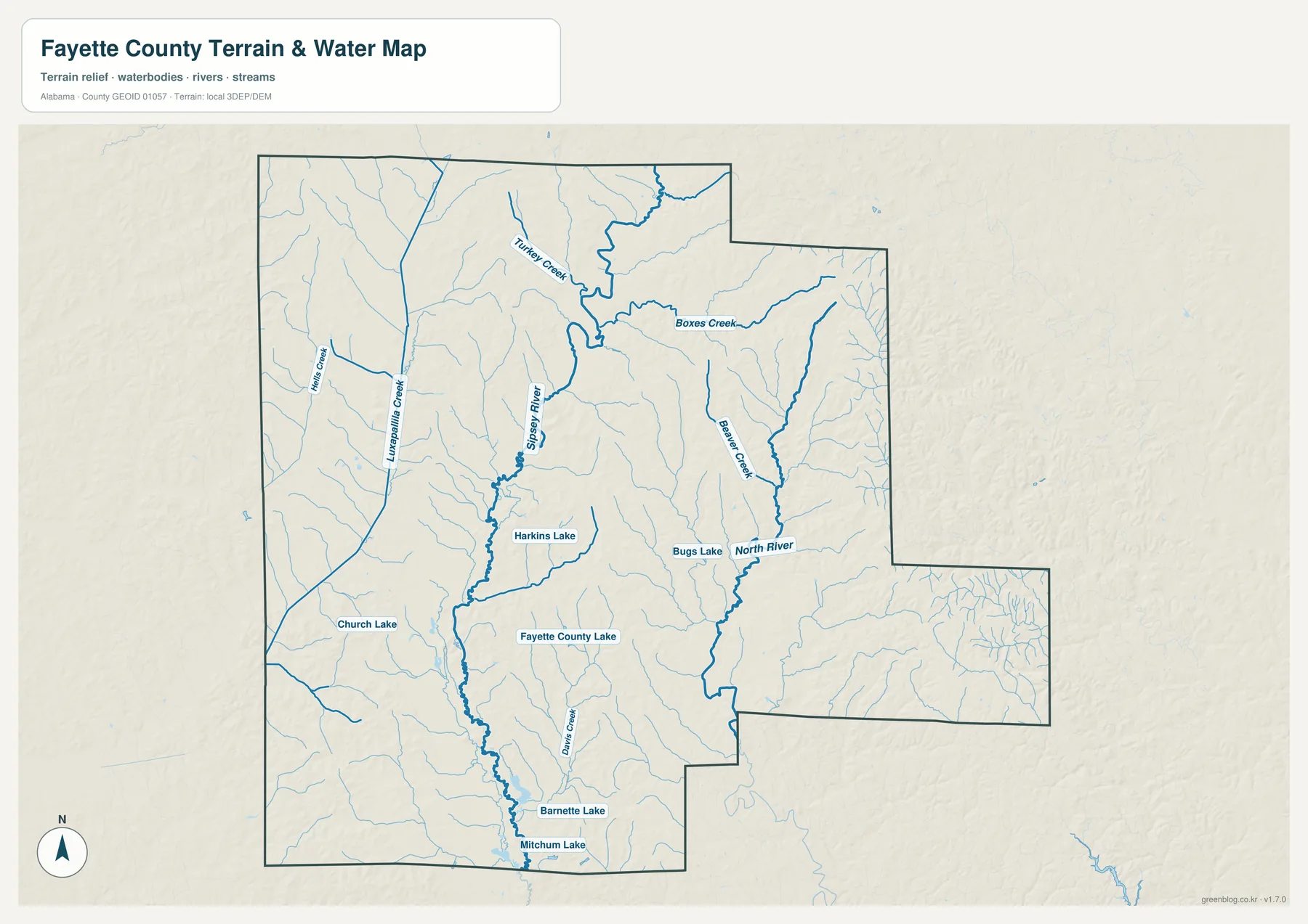
Water is a major part of Fayette County’s physical geography. The water map makes the Sipsey River the most prominent feature and shows a dense network of smaller streams feeding into larger channels. When road labels are reduced, the number of tributaries becomes much more noticeable, especially across the eastern and southeastern portions of the county.
The map also labels North River and several lakes, including Fayette County Lake, along with smaller creeks and local water bodies. Rather than treating the Sipsey River as an isolated blue line, it is more accurate to see it as part of a connected drainage landscape. Small valleys collect water, tributaries join larger streams, and those channels eventually form the river system that continues beyond the county.
Official Alabama and USGS sources also identify the Sipsey River as an important regional waterway, and USGS maintains a monitoring location at Fayette. That makes the river useful both as a map landmark and as a real measured water system. For readers comparing physical geography with settlement, the water map is especially helpful because Fayette’s road-centered position can be viewed separately from the surrounding stream valleys.
Rolling Terrain and Stream Valleys
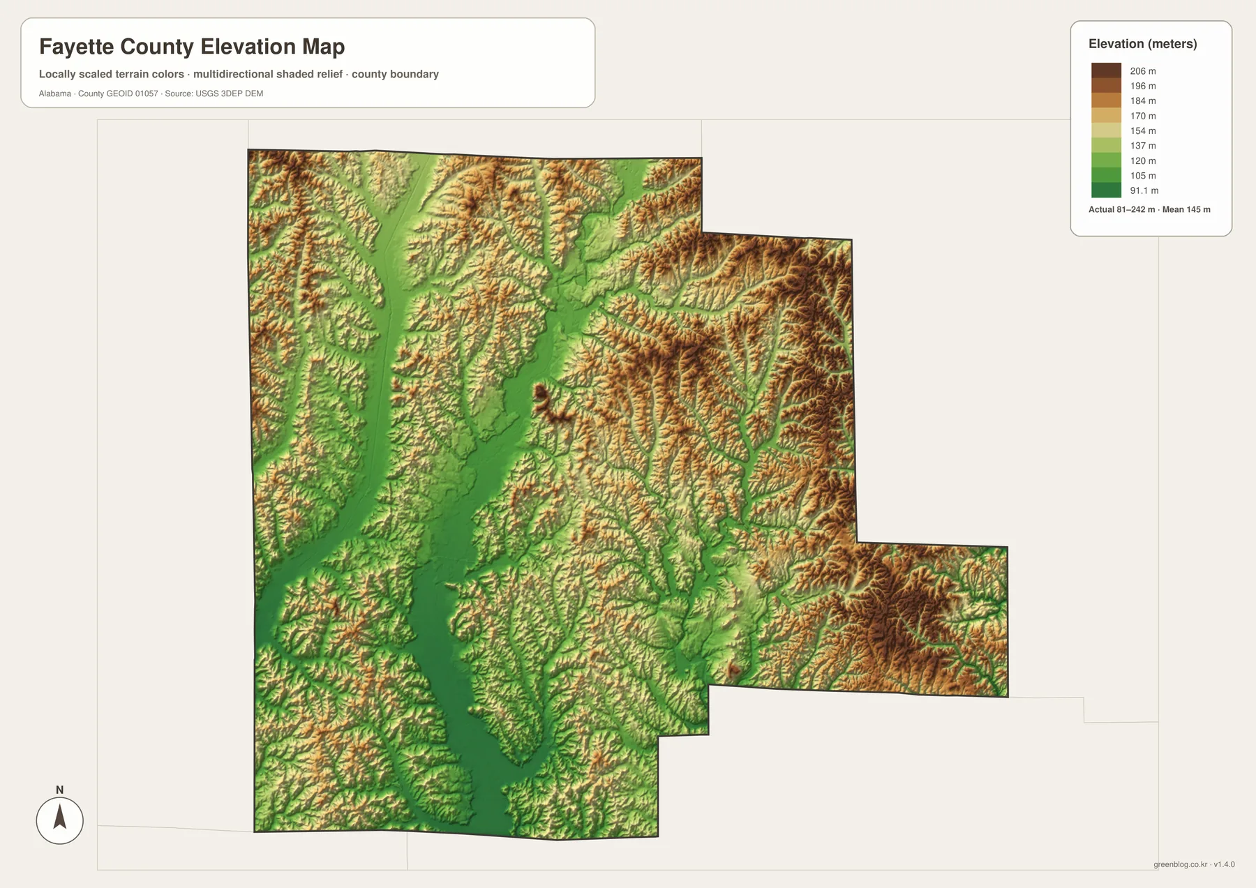
The elevation map shows that Fayette County is not a broad, level plain. Lower stream valleys form long green corridors, while higher ridges and rolling uplands appear in warmer brown tones. The eastern and northern sections are especially dissected, with many narrow valleys separated by short ridges. Similar but broader low corridors are visible through the central and southwestern parts of the county.
This relief helps explain the appearance of both the road map and the water map. Streams naturally occupy the lower ground, while roads must cross or follow the rolling terrain between valleys. Major highways look comparatively direct at county scale, but smaller routes often bend as they pass between ridges, creeks, and settled areas. Switching between the road and elevation views makes those relationships easier to recognize.
The elevation colors are best used for relative comparison rather than precise surveying. A reader can quickly distinguish lower river corridors from higher surrounding ground and see where the terrain becomes more broken. This is particularly useful when studying the Sipsey River system, because the drainage network and the low valleys line up clearly when the two maps are compared.
Which Map Should You Use?
Use the general county map when you need the broadest combination of information: boundary, highways, communities, and streams in one view. It is the most useful starting point for locating Fayette and understanding how U.S. 43, Alabama 18, Alabama 171, Alabama 129, and Alabama 96 connect different parts of the county.
The city map is better when the question is simply where Fayette, Berry, Belk, and Glen Allen sit in relation to each other. For rivers, creeks, and lakes, the water map removes much of the road detail and gives the drainage network priority. The elevation map adds the missing vertical dimension, showing where low valleys and higher ridges shape the landscape.
Using two or more maps together can answer questions that one layer alone cannot. For example, locate Berry on the general map, trace nearby streams on the water map, and then check the elevation map to see the surrounding ridges and valleys. The same approach works around Fayette, Belk, or Glen Allen. Because each image uses the same county boundary, moving from one theme to another is straightforward.
Frequently Asked Questions
Why is Fayette the best reference point on the county map?
Fayette is the county seat and sits where several major routes meet, including U.S. 43, Alabama 18, and Alabama 171. Using Fayette as the starting point makes it easier to place Berry to the east, Belk to the west, and Glen Allen to the north.
Which map shows the Sipsey River most clearly?
The water map gives the clearest view because it emphasizes the Sipsey River, smaller tributaries, North River, and mapped lakes. The general county map still provides road context, while the elevation map helps show the low valleys associated with the drainage network.
What is included in the downloadable ZIP?
The ZIP contains four high-resolution A3 JPG files: a general Fayette County map, a city-connection map, a water map, and an elevation map.
Map File Information
Fayette County A3 Map Files
- File Type: four high-resolution A3 JPG files in one ZIP
Related Maps
- Autauga County Map
- Barbour County Alabama Map
- Butler County Alabama Map
- Alabama Population Density Map: Urban Clusters, County Totals and a Decade of Change
- Fayette County Alabama Land Cover Map Through Forest, Wetlands and Small Developed Centers
Sources and Reference Data
- U.S. Census Bureau TIGER/Line boundary data
- USGS National Hydrography
- USGS 3D Elevation Program
- Fayette County official history and general information
- Outdoor Alabama: Sipsey River
- USGS Sipsey River at Fayette monitoring site
Green Map creates custom-edited map images using open geographic data sources such as geoBoundaries, Natural Earth, OpenStreetMap, and government open data. These maps are edited visual materials, not raw data files, and are provided for education, documents, presentations, and graphic reference.