This Etowah County Map brings together four views of a compact but geographically varied part of northeastern Alabama. You can locate Gadsden and nearby communities, follow the Coosa River into H. Neely Henry Lake, compare the major highway corridors, and see the mountain ridges that rise around the central urban area. If you need printable files rather than the web previews, the download box on this page provides four high-resolution A3 JPG maps in one ZIP archive.
Table of Contents
Gadsden as the center of the county map
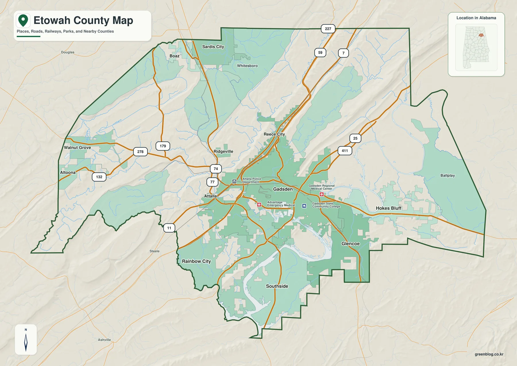
Etowah County sits in northeastern Alabama and borders Marshall, DeKalb, Cherokee, Calhoun, St. Clair, and Blount counties. Gadsden is the county seat and the easiest reference point for reading the map. The city lies on the Coosa River near the middle of the county’s developed area, with Attalla immediately to the west and Rainbow City and Southside extending south toward the reservoir shoreline.
The county becomes less urban as you move away from this central cluster. Sardis City lies to the northeast, while Altoona and Walnut Grove mark the western and southwestern side. Smaller named places appear along local roads, valleys, and uplands rather than forming one continuous built-up area. That contrast is one of the most useful things to notice: Etowah County combines a closely connected metropolitan core with mountain ridges, stream valleys, and more dispersed communities only a short distance away.
Cities and highway connections around Gadsden
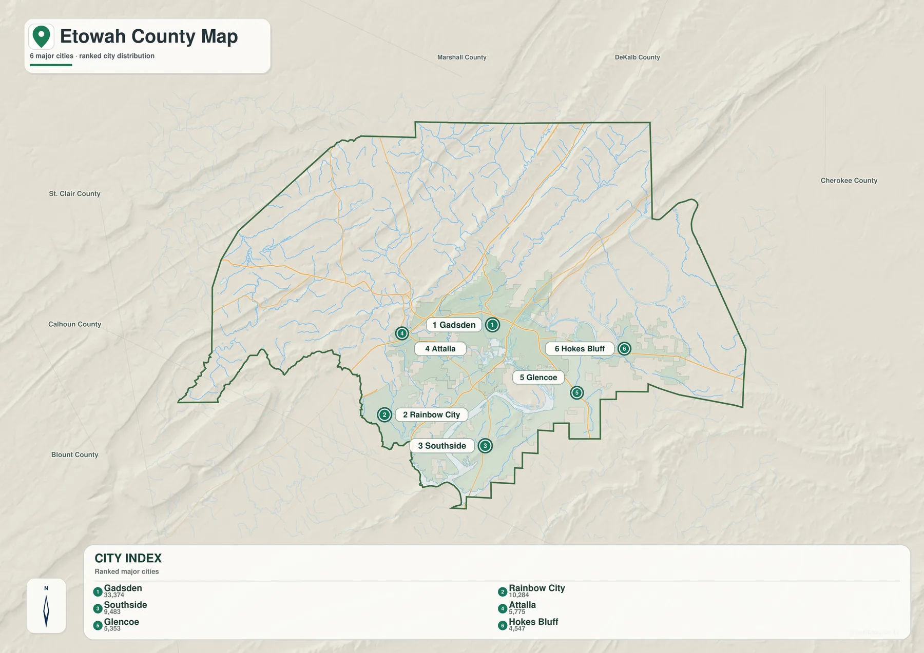
The city map strips away much of the background detail and makes the main urban relationships easy to compare. Gadsden occupies the center of the group. Attalla is just west of it, Rainbow City and Southside are south of the river crossing area, and Glencoe and Hokes Bluff sit to the east and southeast. These places are close enough that their road networks and daily travel patterns overlap, even though each municipality has its own boundary.
Interstate 59 runs along the western side near Attalla and Reece City, carrying regional traffic toward Birmingham to the southwest and DeKalb County to the northeast. I-759 is much shorter, but it is important because it leaves I-59 and heads directly toward Gadsden, crossing the Coosa River into the urban area. U.S. 278 and U.S. 431 serve the eastern and northeastern side, while U.S. 411 and Alabama 77 are useful for reaching the southern communities around the river and reservoir. Reading the routes together with the city locations explains more than a list of highway numbers alone.
The Coosa River and the H. Neely Henry Lake corridor
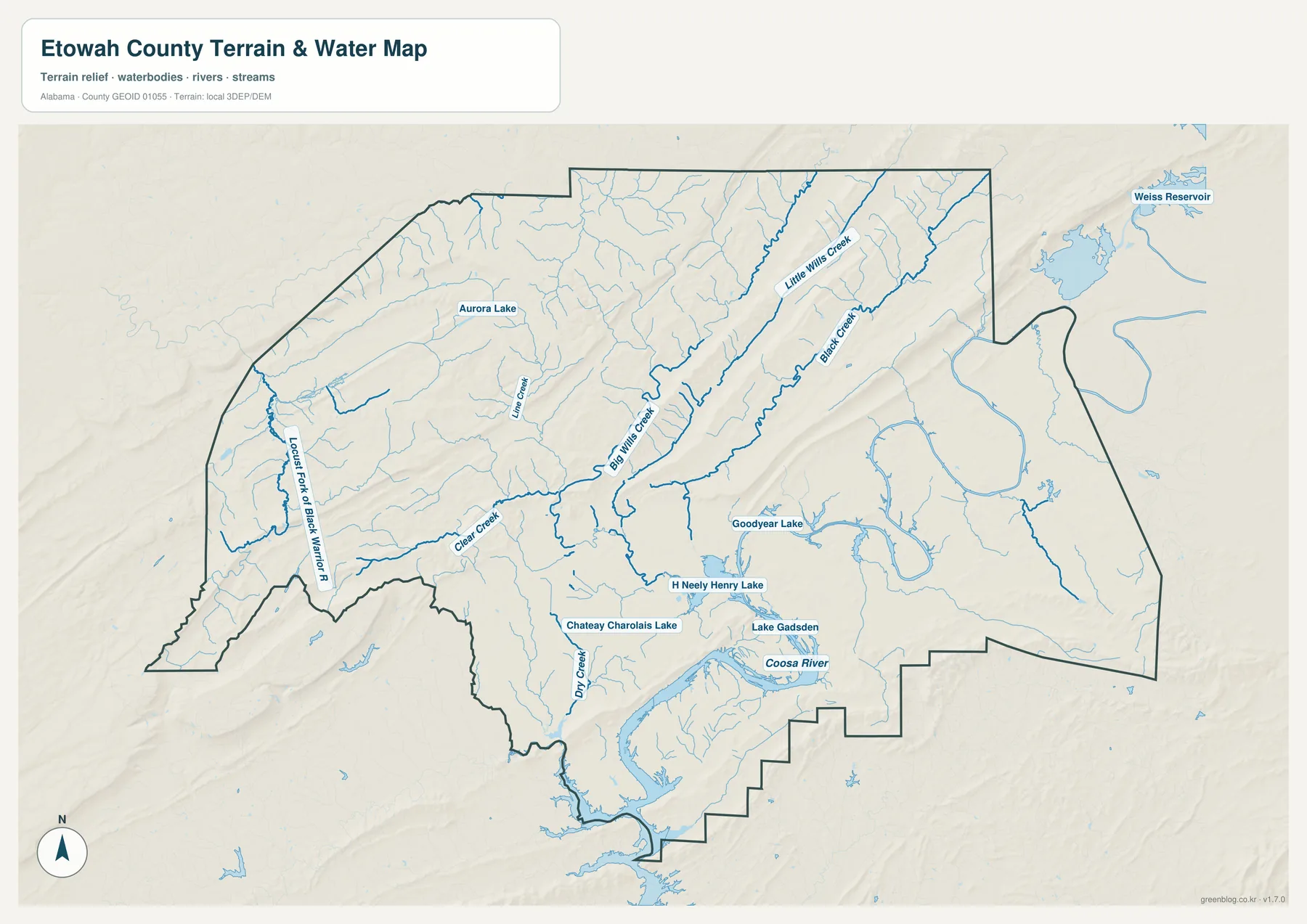
Water is a defining feature of the county’s central and southern geography. The Coosa River passes through Gadsden and continues downstream into the long, branching surface of H. Neely Henry Lake. On the water map, the change is easy to see: the river is comparatively narrow through the urban core, then broadens into a reservoir with coves and extended shoreline farther south. That shape affects where roads can cross and helps explain why some nearby neighborhoods require indirect travel around water.
The map also shows tributaries and smaller water bodies, including Big Wills Creek, Lake Gadsden, and other named streams that feed the main system. These waterways descend from higher ground and converge toward the Coosa. H. Neely Henry Lake is not a separate natural lake system; it is a reservoir on the Coosa River. Treating the Gadsden riverfront and the lake farther south as one connected water corridor makes the county’s physical layout much easier to understand.
Mountain ridges, low river land and elevation change
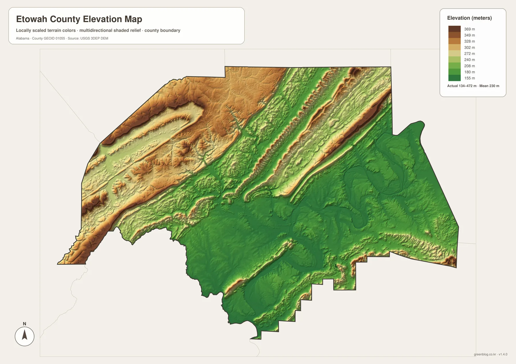
The elevation map adds a very different view of Etowah County. Higher ground is concentrated along the northwestern side and in long ridges across the north and northeast. Lower elevations spread through the Gadsden area and along the Coosa River and reservoir. The terrain is therefore not a smooth slope from one side of the county to the other. Instead, narrow ridges and valleys create repeated bands of higher and lower ground.
The legend on the provided elevation image ranges from roughly 114 meters to 417 meters. That difference is large enough to explain visible changes in road alignment and settlement. The flatter, lower river corridor is better suited to a continuous urban network, while roads crossing the higher ridges often follow valleys, gaps, or curving slopes. The broad contrast between the western and northeastern ridges and the lower central-southern corridor is especially clear when the elevation map is compared with the city map.
How to use the four Etowah County maps
If you are new to the county, begin with the general map and locate Gadsden, the county boundary, and the largest roads. Then switch to the city map to simplify the urban pattern: Attalla lies west of Gadsden, Rainbow City and Southside are south, and Hokes Bluff and Glencoe sit toward the east and southeast. The water map explains why the southern side is shaped by bridges and shoreline, while the elevation map shows why the developed river corridor is bordered by distinctly higher ground.
This sequence also works well for trip planning, school assignments, and regional study. For a westbound route, look toward Attalla and I-59. For the southern side, compare U.S. 411 and Alabama 77 with the Coosa River and reservoir shoreline. For the eastern side, use Hokes Bluff, U.S. 278, and U.S. 431 as reference points. The high-resolution files are especially useful when you need larger labels or want to print a map rather than view it on a screen.
Local background behind the mapped landscape
Etowah County was created in 1866 under the name Baine County and received its present name in 1868. County material identifies Gadsden as the county seat and points to Sand Mountain, Lookout Mountain, and Noccalula Falls as notable parts of the local landscape. Those names fit what appears on the maps: higher ground surrounds a lower central corridor where the river, urban development, and major transportation routes come together.
Gadsden’s early history was closely connected to the Coosa River. City historical material describes an earlier settlement known as Double Springs and notes the arrival of the steamboat Coosa near the present Memorial Bridge area in 1845. River transportation is no longer the main way people move through the county, but the old relationship between the city and the water remains obvious in the modern map. Downtown Gadsden, major bridges, I-759, and several highways are all concentrated close to the river.
Farther downstream, H. Neely Henry Lake changes both the appearance and the movement pattern of southern Etowah County. Alabama Power describes the reservoir as covering about 11,200 acres with roughly 339 miles of shoreline. The large amount of shoreline comes from its long river shape and many branching coves. That geometry is why Southside and other southern communities can be geographically close across water while still depending on a limited set of road crossings.
The county’s steepest local scenery is also close to the urban area. Noccalula Falls lies northwest of central Gadsden, where Black Creek drops into a gorge. This quick transition from city streets to steep terrain is a good example of the county as a whole: low river land, narrow valleys, and high ridges occur within short distances. The elevation map makes that contrast visible without requiring technical terrain analysis.
Frequently Asked Questions
What files are included in the Etowah County map download?
The ZIP contains four A3 high-resolution JPG files: the general county map, a major-city map, a water map, and an elevation map. They are intended for larger viewing and printing than the WebP previews shown in the article.
Is H. Neely Henry Lake separate from the Coosa River?
No. H. Neely Henry Lake is a reservoir formed on the Coosa River. The river flows through Gadsden and expands downstream into the reservoir, so both features belong to one continuous water system.
Why do several major highways meet near Gadsden?
Gadsden is the county seat, a major river crossing, and the center of the county’s largest urban cluster. I-59 approaches from the west, I-759 links that interstate with Gadsden, U.S. 278 and U.S. 431 serve the east, and U.S. 411 and Alabama 77 connect the southern river communities.
Map File Information
Etowah County map files
- Included Files: 4 high-resolution A3 JPG maps: county, city, water, and elevation
- File Type: JPG files in a ZIP archive
- Intended Use: Printing, education, presentations, and map-based projects
Related Maps
Sources and reference material
- Etowah County official history and geography
- Gadsden-Etowah Metropolitan Planning Organization
- ALDOT Highway Functional Classification Maps
- Alabama Power: H. Neely Henry Lake
- USGS National Hydrography
- USGS 3D Elevation Program
Green Map creates custom-edited map images using open geographic data sources such as geoBoundaries, Natural Earth, OpenStreetMap, and government open data. These maps are edited visual materials, not raw data files, and are provided for education, documents, presentations, and graphic reference.