Martin County Florida Map readers can use this page to see the county from the Stuart waterfront to inland Indiantown and the eastern edge of Lake Okeechobee. You can also download the three high-resolution A3 JPG map files as one ZIP, including the county reference map, the city-location map, and the water map.
Martin County is easiest to understand as a long county with two very different ends. The eastern side is shaped by the St. Lucie River, the Indian River Lagoon, barrier islands, and a dense web of roads around Stuart. Farther west, the map opens into a much broader interior where Indiantown, canals, agricultural land, and the Lake Okeechobee side of the county become the main reference points. That contrast is more useful than treating Martin County as only a coastal strip.
Table of Contents
From Stuart to Indiantown: the shape of Martin County
Martin County runs west from the Atlantic side of Florida between St. Lucie County to the north and Palm Beach County to the south. On the county map, the eastern communities occupy a relatively narrow area near the river, lagoon, and coast, while the county broadens dramatically toward the interior. Indiantown appears far west of Stuart, making it clear that the county covers much more than the Treasure Coast communities most visitors recognize first.
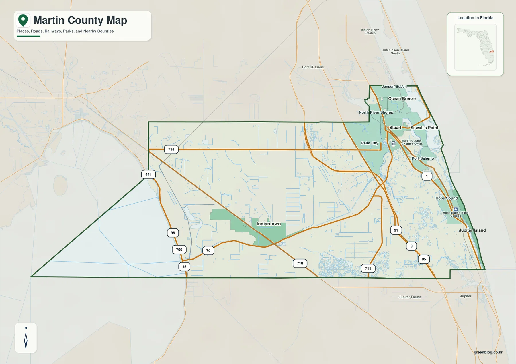
Stuart is the clearest reference point on the eastern side. Jensen Beach and Ocean Breeze are north of it, Sewall’s Point lies close to the estuary on the east side, and Port Salerno and Hobe Sound are farther south. Palm City sits west of Stuart across the river system. Along the Atlantic side, Jupiter Island forms a long, narrow coastal strip that is visually separate from the mainland communities.
The road network reinforces the east–west difference. U.S. 1 stays close to the eastern mainland, while I-95 and Florida’s Turnpike run farther inland as the primary long-distance north–south routes. SR 714, SR 76, and SR 710 help connect the Stuart–Palm City side with the interior and Indiantown area. When planning a route across the county, it is useful to identify the north–south highway first and then follow the east–west road that reaches the destination.
Settlements around the St. Lucie River
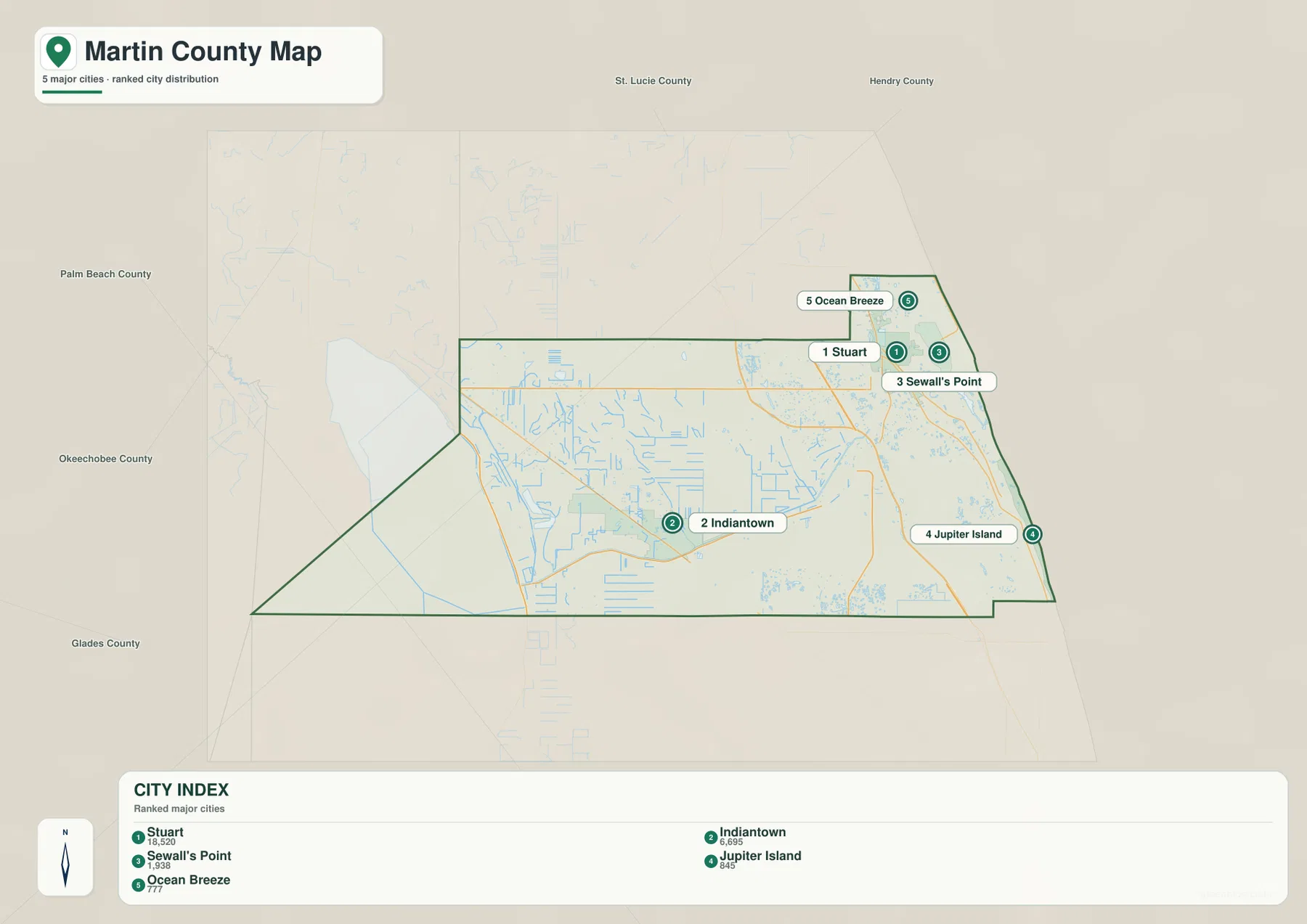
The city-location map simplifies the county by emphasizing five incorporated places: Stuart, Indiantown, Sewall’s Point, Jupiter Island, and Ocean Breeze. Stuart is the largest of the five in the map’s city index and sits near the center of the eastern cluster. Indiantown is the outlier, separated from the coastal side by a long stretch of interior Martin County. The other three are much smaller places concentrated near the lagoon and coast.
Downtown Stuart is not directly on an Atlantic Ocean beach. It is inside the St. Lucie River estuary, with the lagoon and barrier-island system between the city and the open ocean. That distinction matters when reading a map for travel: a beach that appears close in a straight line may require a bridge crossing and a different road approach. The map therefore works better when the water system is considered together with the street and highway network.
Palm City is west of Stuart across the river, while Port Salerno lies to the southeast near protected water. Hobe Sound is farther south on the mainland, and Jupiter Island is the narrow barrier island on the ocean side. These places can appear tightly grouped at county scale, but the river, lagoon, and island channels create real separation between them. Comparing the city and water maps helps prevent the common mistake of assuming that every nearby label is directly connected by road.
How the river, lagoon, and Atlantic coast fit together
The water map makes eastern Martin County much easier to understand. The North Fork and South Fork of the St. Lucie River come together in the Stuart-area estuary, and the larger system continues toward the Indian River Lagoon and the Atlantic through the inlet area. This creates a coastal landscape where mainland roads, riverfront communities, islands, and ocean access are all close together but not interchangeable.
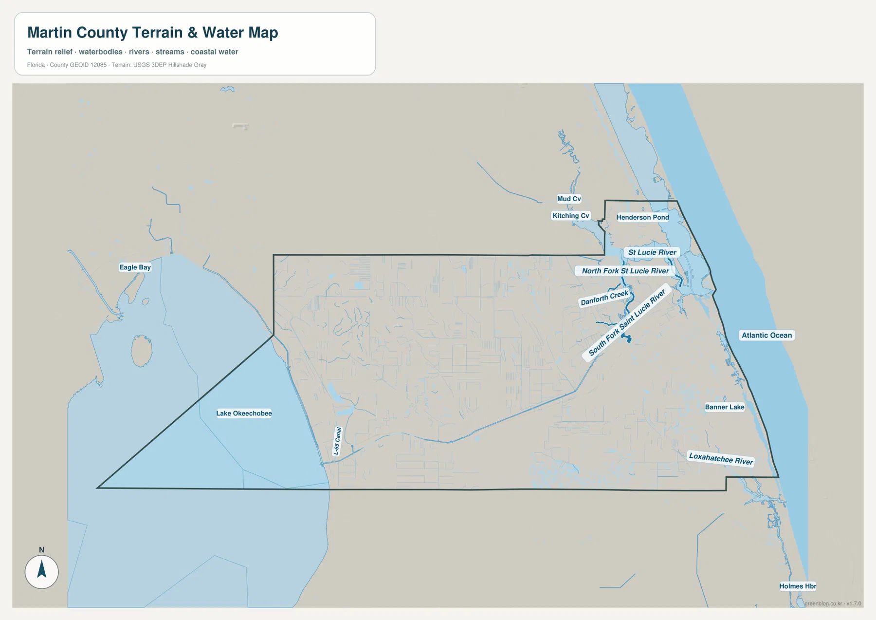
Several named features are visible in the eastern part of the water map, including St. Lucie River, North Fork St. Lucie River, South Fork St. Lucie River, and Danforth Creek. The Atlantic Ocean is shown along the coast, and the Loxahatchee River appears near the southeastern edge. Smaller coves, ponds, and channels also appear around the estuary, reinforcing how water divides and connects the communities around Stuart.
The western side presents a different picture. Lake Okeechobee occupies the broad western edge, and the map also marks the L-65 Canal. Source material preserved with the county package identifies the C-44 Canal, or St. Lucie Canal, as the eastern part of the Okeechobee Waterway connecting the lake with the St. Lucie River system. It passes south of the Indiantown area before the route reaches the eastern river network. This relationship explains why inland Martin County belongs to the same water-management system as the Stuart estuary even though the landscapes look very different.
Indiantown and the wide interior of the county
Indiantown should be treated as a separate western reference point rather than a small extension of the Stuart area. On the map, it sits near SR 710 and SR 714, well inland from the coast and north of the canal corridor described in the source material. The surrounding road pattern is less dense, so route numbers and long east–west connections are more important than the closely spaced local streets found near Stuart.
Farther west, the county map also shows routes linking toward U.S. 441, U.S. 98, and U.S. 27 corridors around the Lake Okeechobee region. These routes matter when Martin County is viewed together with Okeechobee and other interior counties. By contrast, someone moving among Jensen Beach, Stuart, Port Salerno, and Hobe Sound will rely much more on U.S. 1 and the eastern highway system. The best road to look for depends strongly on which side of the county the trip begins.
The county boundary itself helps explain that difference. St. Lucie County borders Martin County on the north, Palm Beach County lies to the south, and the western side reaches the Lake Okeechobee area. A trip north from Stuart toward Port St. Lucie follows a very different regional connection from a trip west from Indiantown toward Okeechobee. The county map is especially useful for seeing both relationships on one page.
Choosing between the county, city, and water maps
Use the county map when the main question is about boundaries, highways, and the relationship between the eastern communities and inland Martin County. It shows Stuart, Palm City, Jensen Beach, Port Salerno, Hobe Sound, Indiantown, and nearby county names in the same frame. It is the best starting point for understanding the county’s overall extent and for tracing longer routes.
The city-location map is better when incorporated places are the priority. It reduces the visual clutter and highlights Stuart, Indiantown, Sewall’s Point, Jupiter Island, and Ocean Breeze. The water map is the stronger choice for questions about the St. Lucie River forks, the Atlantic side, Lake Okeechobee, and the network of creeks and channels around the estuary. Switching between these views is often faster than trying to make one map answer every question.
There is no required order. For a Stuart-to-beach question, start with the water map so the river and ocean relationship is clear, then use the county map for the road approach. For Indiantown, the city map quickly establishes how far west it is, and the county map then shows the numbered routes leading toward it. The maps are most useful when they are selected according to the specific location question.
Practical notes for printing and route planning
These maps are designed as county reference maps for location, road, and water context. In the eastern part of the county, bridges and water crossings can make a short map distance longer by road, so checking both the route and the water between two places is important. In the western part, long highway segments and fewer concentrated place labels make route numbers more useful than visual proximity.
The water map is not a flood-risk map or a navigation chart, and the county map is not a parcel or legal-boundary survey. They are best used for broad geographic orientation, school or presentation material, printed reference sheets, and early-stage travel planning. For legal property boundaries, navigation, or detailed engineering information, use the appropriate official source in addition to these reference maps.
Frequently Asked Questions
Why should I check the river and lagoon when looking for an Atlantic beach from Stuart?
Downtown Stuart is inside the St. Lucie River estuary rather than directly on the open Atlantic. Reaching the beach generally requires crossing the water toward the barrier-island side, so the water map helps explain the separation and the county map helps identify the road approach.
How is Indiantown connected with the coastal side of Martin County?
Indiantown is far west of Stuart and is reached through the interior road network, especially routes such as SR 710 and SR 714. The C-44 or St. Lucie Canal system also passes south of the area and links the Lake Okeechobee side with the St. Lucie River system, making western Martin County part of the same larger water corridor.
Which water features should I locate first on the water map?
Start with the St. Lucie River and its North and South forks around Stuart, then compare that eastern system with the Atlantic coast. On the western side, locate Lake Okeechobee. Those two reference areas make the county’s east–west water geography much easier to understand before looking at smaller creeks, coves, and canals.
Map File Information
Download the Martin County county map, city-location map, and water map as high-resolution A3 JPG files. One ZIP contains all three JPGs.
- Included Files: County map, city-location map, water map
Related Maps
- Arcadia Roads and Peace River | DeSoto County Florida Map
- Baker County Florida Map
- Between the Aucilla and Withlacoochee: Madison County Florida Map
Sources
- U.S. Census Bureau Martin County QuickFacts
- Florida Department of Transportation Martin County map
- Martin County St. Lucie Inlet overview
- U.S. Army Corps of Engineers Okeechobee Waterway overview
- Discover Martin communities
Green Map creates custom-edited map images using open geographic data sources such as geoBoundaries, Natural Earth, OpenStreetMap, and government open data. These maps are edited visual materials, not raw data files, and are provided for education, documents, presentations, and graphic reference.