Marion County Florida Map visitors can use this page to locate Ocala, compare the smaller towns around it, follow the main highway corridors, and see where the county’s best-known rivers and lakes sit. Ocala is the central reference point, but the map reaches far beyond the city: Reddick and McIntosh lie to the north, Belleview is south, Dunnellon is southwest, and Silver Springs is east. The page also provides a ZIP download containing the three original A3 high-resolution JPG maps shown here: a county map, a city-connections map, and a water map.
Marion County is a large inland county in north-central Florida, and its geography changes noticeably from one side to another. The west and northwest contain broad rural and equine areas, while the east is shaped by Silver Springs, the Silver River, the Ocklawaha River, numerous small lakes, and the forested landscape toward Ocala National Forest. Dunnellon forms a separate southwestern center near the Withlacoochee and Rainbow river system. Looking at those directions first makes the three map layers much easier to interpret.
Table of Contents
Ocala, the county outline, and the roads that organize Marion County
The county map places Ocala near the middle of the settled part of Marion County, with I-75 running north-south just west of the city. SR 40 crosses Ocala from west to east, while US 27 angles toward the northwest and US 301 and US 441 provide major north-south connections. These routes are useful reference lines for locating the rest of the county. Reddick is well north of Ocala, Belleview is to the south, Dunnellon is in the southwest corner, and Silver Springs lies east of the city along the SR 40 corridor.
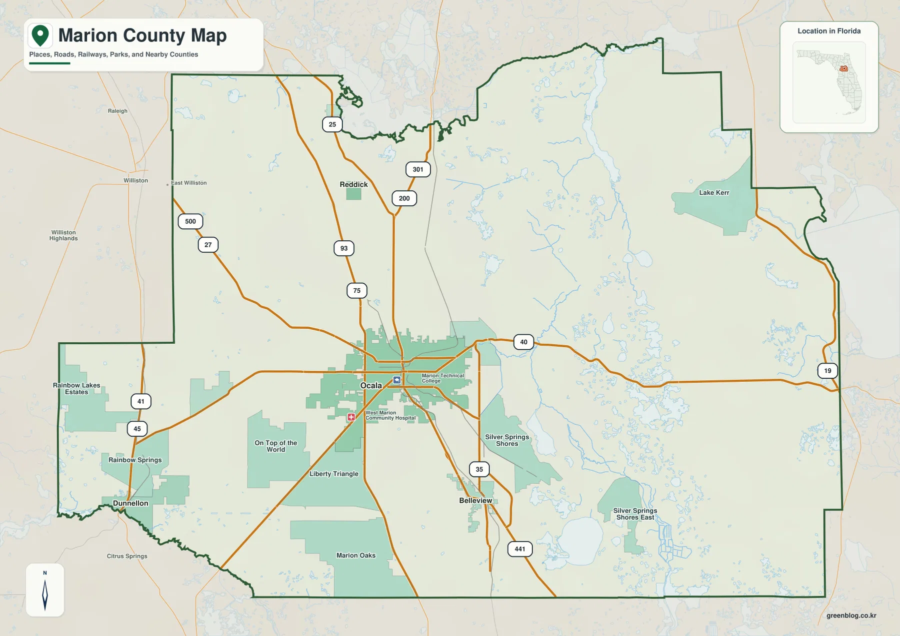
The same map also shows why Marion County cannot be reduced to the Ocala urban area. On Top of the World, Liberty Triangle, Marion Oaks, Rainbow Lakes Estates, Silver Springs Shores, and other large community labels extend the inhabited landscape beyond incorporated city limits. Dunnellon sits close to the southwestern county edge, while the northern towns are separated by long rural stretches. In the east, road labels become less dense and water features become more prominent. Lake Kerr, Silver Springs Shores, and the network of small lakes and creeks help distinguish the eastern side from the farm and highway landscape west of Ocala.
Neighboring counties provide another useful frame. Alachua County is to the north, Putnam to the northeast, Volusia to the east, Lake to the southeast, Sumter to the south, Citrus to the southwest, and Levy to the west. Marion County has no coastline, but it has enough springs, rivers, lakes, and wet areas that water still creates strong internal geographic divisions. That contrast between an inland county and a water-rich landscape is one of the clearest themes visible across the supplied maps.
How Belleview, Dunnellon, Reddick, and McIntosh sit around Ocala
The city-connections map strips away much of the extra detail and uses Ocala as the hub. Belleview is shown about 11 miles south of Ocala, Reddick about 14 miles north, Dunnellon about 19 miles southwest, and McIntosh about 20 miles north. These are direct straight-line distances, not driving distances. Actual road trips are longer because travelers must follow the highway network, but the measurements are useful for comparing the direction and relative spacing of the incorporated towns.
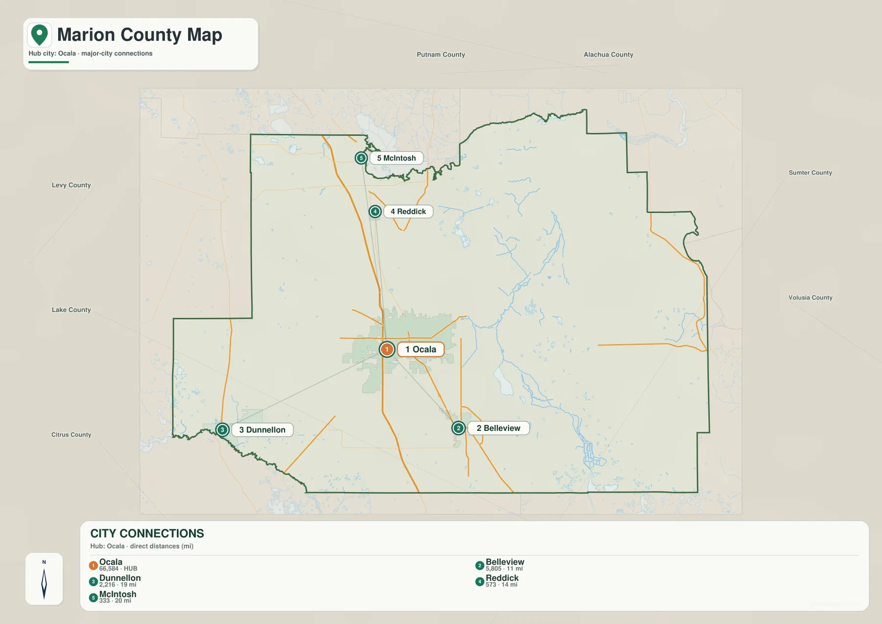
Belleview is the closest of the four mapped cities and follows the US 301-US 441 corridor south of Ocala. Reddick and McIntosh occupy the northern part of the county, but McIntosh is farther north and lies close to Orange Lake. Dunnellon is different from all three because it is positioned far to the southwest near the Withlacoochee and Rainbow river area. The pattern makes it clear that Marion County’s incorporated places are not arranged as one continuous urban chain. They form separate local centers connected through Ocala and several major highways.
This simplified city map is especially helpful when the full county map feels crowded. For example, a reader trying to compare McIntosh and Reddick can ignore the many community labels and focus only on their north-south relationship to Ocala. The same approach works for Dunnellon and Belleview: both are south of the northern towns, but one is southwest and river-oriented while the other lies on the central highway corridor. The distinction matters for understanding both travel direction and the different landscapes around each town.
Silver River, Ocklawaha River, Lake Weir, and the western river system
The water map shifts attention away from highways and toward the county’s drainage features. East of Ocala, the Silver River begins at Silver Springs and flows to the Ocklawaha River. The Ocklawaha then runs through a much larger north-south corridor in eastern Marion County. Cedar Creek, Eton Creek, and other smaller waterways appear around that system, while numerous ponds and lakes fill the eastern half of the map. Lake Weir stands out in the southeast as one of the largest mapped lakes and provides a useful landmark for the communities south and east of Belleview.
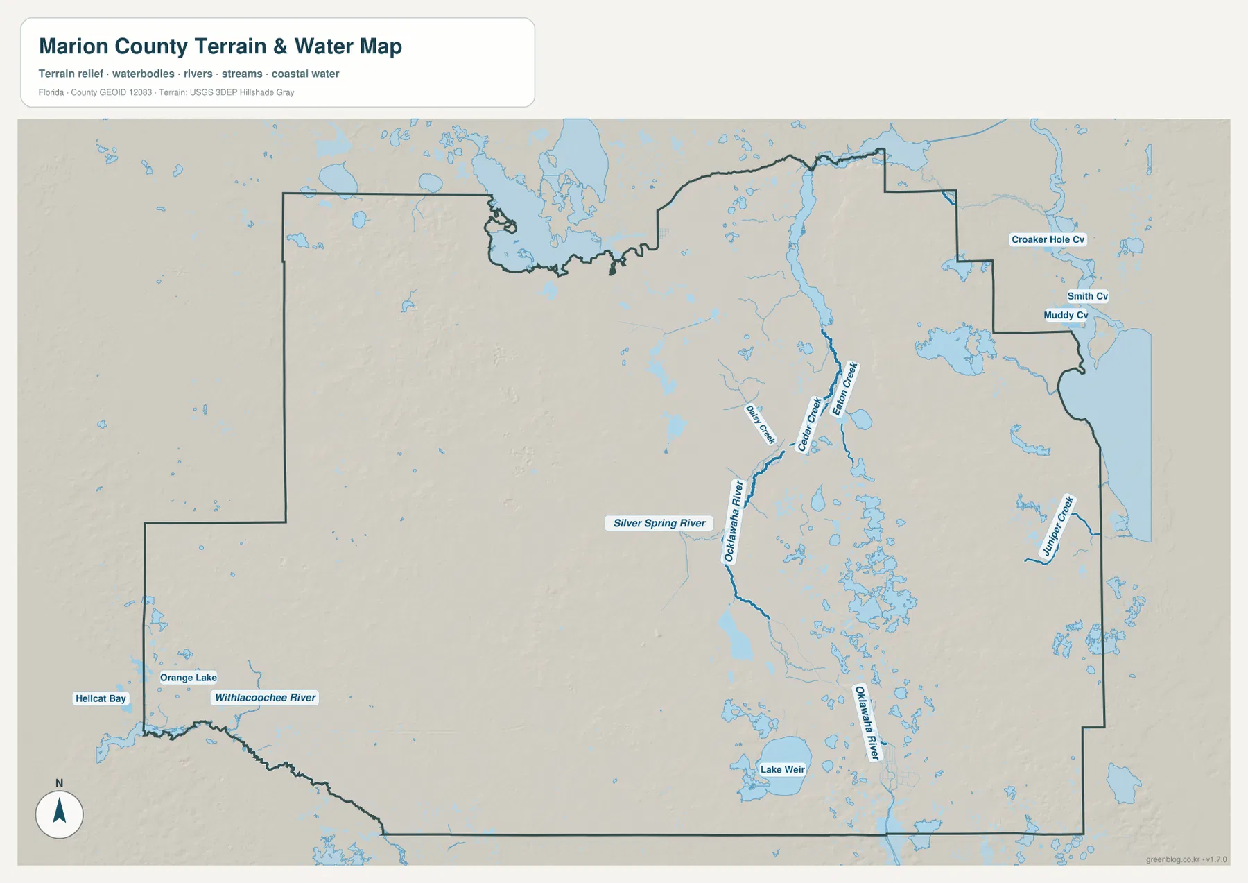
The western side belongs to a different set of waterways. The Withlacoochee River runs along part of the southwestern edge near Dunnellon, and the map also labels Hellcat Bay nearby. Orange Lake appears in the northwest, close to McIntosh and the northern county line. These features make it easier to see why Dunnellon and Silver Springs should not be treated as two attractions in the same corner of the county. Dunnellon is tied to the Withlacoochee and Rainbow river setting in the southwest, while Silver Springs feeds the Silver River and then the Ocklawaha on the opposite side of Ocala.
The water layer is intended as a geographic reference. It does not show flood zones, parcel boundaries, channel depth, navigational hazards, or legal shoreline limits. Its strength is simpler: it helps answer where a river or lake lies in relation to Ocala, the smaller towns, and the county boundary. A reader looking for Lake Weir, Orange Lake, or the path from Silver Springs to the Ocklawaha River will usually find this layer clearer than the general county map.
Why western Marion County and eastern Marion County look so different
Western and northwestern Marion County are widely associated with pasture and horse farms. The existing county material notes more than 195,000 acres of equine-related land, and the supplied county map reflects a broad rural landscape west and northwest of Ocala. US 27 is a useful reference route through this part of the county. Large developed labels are relatively sparse compared with the Ocala core, and the distance between major roads is often greater.
Travel east on SR 40 and the setting changes. Silver Springs appears just east of Ocala, followed by the Silver River and the Ocklawaha River corridor. Beyond that lies the broad forested area associated with Ocala National Forest. The national forest is not a city park in downtown Ocala; it is a separate federal forest east of the city. Reading Ocala, Silver Springs, the river corridor, and the forest as successive locations is more accurate than treating all four names as if they refer to one place.
The southeast provides another variation. Lake Weir and its surrounding small lakes create a water-rich landscape that differs from both the central Ocala road network and the broad forest farther east. Belleview sits northwest of this lake district, while Ocklawaha and the Weirsdale area are farther toward Lake Weir. Together, these contrasts explain why a single “Ocala area” label cannot describe the whole county: Marion County contains a central city, northern small towns, western farm country, a southwestern river center, eastern spring and forest country, and a southeastern lake district.
The highway pattern that connects farms, towns, springs, and lakes
I-75 is the principal north-south interstate and stays west of central Ocala. Several major routes meet or approach it, including CR 484, SR 200, SR 40, US 27, and SR 326. SR 40 is the clearest east-west reference because it passes through Ocala and continues toward Silver Springs and the forested eastern side. SR 200 runs southwest from Ocala, while US 27 heads northwest. These different directions help separate the major parts of the county without relying on municipal boundaries alone.
US 301 and US 441 are particularly important through the central corridor. They pass through or near Belleview and Ocala, then continue north before their routes diverge. US 441 is the useful reference for Reddick and McIntosh, while US 301 continues toward the northeastern part of the county. On the supplied maps, this creates a clear distinction between the I-75 corridor west of Ocala and the US 301-US 441 corridor through the city and smaller towns. For someone trying to understand where a community sits rather than simply how to drive there, those two north-south paths are the most helpful starting points.
Choosing the Marion County map that fits your question
Use the county map when you need the broadest combination of boundaries, communities, major roads, and natural features. It is the best choice for comparing Ocala with Dunnellon, Reddick, Belleview, Silver Springs, and the outer parts of the county. Use the city-connections map when the main question is how Belleview, Dunnellon, Reddick, and McIntosh are positioned around Ocala. Use the water map when the Silver River, Ocklawaha River, Withlacoochee River, Orange Lake, Lake Weir, or the smaller eastern creeks are the focus. Switching between the three keeps each layer readable instead of forcing every label into one crowded view.
The downloaded JPG files are larger than the web previews, making it easier to zoom in on road shields, town names, river labels, and smaller lakes. They are general-reference maps rather than legal surveys, parcel maps, flood products, engineering drawings, or navigation charts. Use specialized official data for property boundaries, construction, flood regulation, or marine decisions.
Frequently Asked Questions
Are Silver Springs and Ocala National Forest in the same place?
No. Silver Springs is just east of Ocala along the SR 40 corridor, and the Silver River begins there before joining the Ocklawaha River. Ocala National Forest is a much larger federal forest farther east. A simple way to read the map is to move east from Ocala to Silver Springs, then toward the river corridor and the forest beyond it.
Does the river system at Dunnellon connect directly to the Silver River?
No. Dunnellon is in southwestern Marion County near the Withlacoochee and Rainbow river setting. The Silver River is east of Ocala and flows into the Ocklawaha River. Both are important spring-fed water landscapes within the same county, but they lie on opposite sides of Ocala and belong to different river systems.
Are the distances on the city map driving distances?
No. The city map uses straight-line distances from Ocala: about 11 miles to Belleview, 14 to Reddick, 19 to Dunnellon, and 20 to McIntosh. Driving distances will usually be longer because vehicles must follow the road network. The values are best used for orientation and relative comparison rather than route planning.
Map File Information
The ZIP contains the original A3 high-resolution JPG versions of the county map, city map, and water map shown on this page.
- Included Files: county map, city map, water map
- File Type: ZIP containing 3 JPG files
Related Maps
- Arcadia Roads and Peace River | DeSoto County Florida Map
- Baker County Florida Map
- Between the Aucilla and Withlacoochee: Madison County Florida Map
Sources and References
- Marion County Government
- Florida Department of Transportation – Marion County transportation network
- St. Johns River Water Management District – Silver Springs and Silver River
- U.S. Forest Service – Ocala National Forest
- U.S. Census Bureau QuickFacts – Marion County
Green Map creates custom-edited map images using open geographic data sources such as geoBoundaries, Natural Earth, OpenStreetMap, and government open data. These maps are edited visual materials, not raw data files, and are provided for education, documents, presentations, and graphic reference.