The Spartanburg County Map on this page combines the county’s main road network, ranked city distribution, and river systems in a single download-oriented reference. The previews show Spartanburg, Greer, Lyman, Duncan, Woodruff, I-85, I-26, the Pacolet River system, the Tyger River branches, and several named lakes. Matching high-resolution A3 JPG files are available together in a ZIP archive for printing, reports, and classroom use.
The general county map is the best place to start when roads and communities matter. The city map simplifies the county into six ranked places, making the west-central cluster easy to distinguish from Woodruff in the south. The terrain-and-water map removes much of the road detail and brings the North and South Pacolet rivers, Lake William C Bowen, the three Tyger branches, and the Enoree River into focus. Moving between those views is much clearer than trying to extract every type of information from one crowded image.
Table of Contents
Spartanburg anchors I-85, I-26, US 29, and US 176
Spartanburg is the strongest road reference near the center of the county. I-85 crosses the northern side of the urban area, linking the Greer-Duncan side in the west with Cowpens and the eastern side of the county. I-26 approaches through the southern and western part of the map. US 29 and US 176 add useful east-west and northwest-southeast references around Spartanburg itself.
The secondary route pattern changes as you move away from the city. Routes 9, 11, 42, 43, and 292 help organize Campobello, Inman, and Chesnee in the north. The west has 357 and 296 around the Lyman-Greer side, while 221, 150, 146, 56, and 49 appear through the broad southern section toward Woodruff. Thinking of the network as several directional branches from Spartanburg is easier than treating the numbered routes as an isolated list.
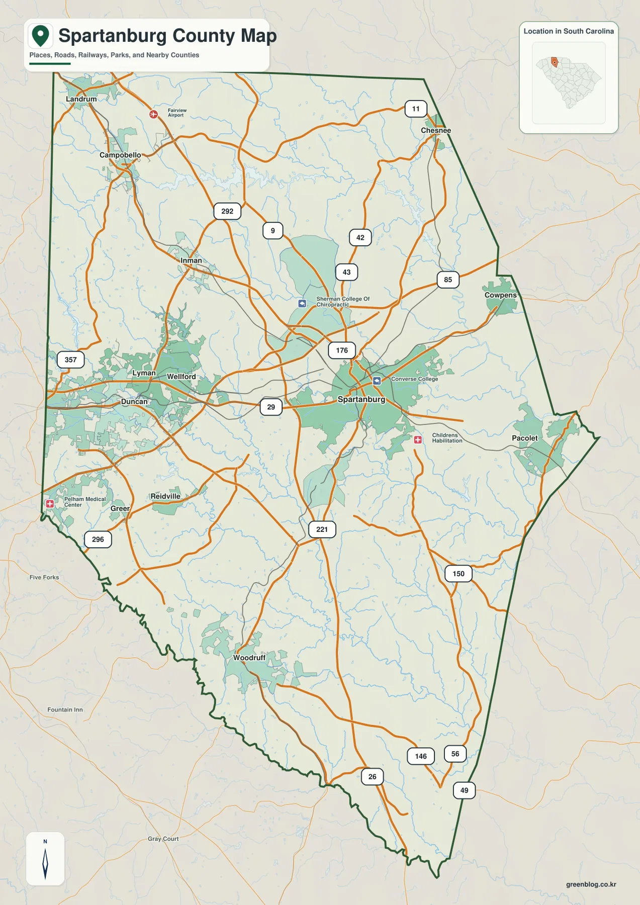
The western side is noticeably more crowded with communities. Greer, Duncan, Lyman, and Wellford sit relatively close to one another, with Inman and Campobello farther north. East of Spartanburg, Cowpens and Pacolet are more separated, and Woodruff stands apart in the south. The map therefore shows several distinct settlement groups rather than a county organized around one compact urban center.
The ranked city map separates the Greer cluster from Spartanburg and Woodruff
The city map ranks Greer first and Spartanburg second, followed by Lyman, Woodruff, Duncan, and Wellford. The important part of the map is not simply the order but the placement of the markers. Greer, Lyman, Duncan, and Wellford form a west-central group, Spartanburg is farther east, and Woodruff is well to the south.
This simplified view is useful before opening the denser road map. A reader looking for Greer or Duncan can immediately focus on the western boundary, while Spartanburg serves as the central reference and Woodruff is easy to isolate in the southern portion. Greenville County is labeled on the west, Laurens County to the southwest, Union County to the east, and Cherokee County to the northeast, helping frame where those city groups sit inside the county.
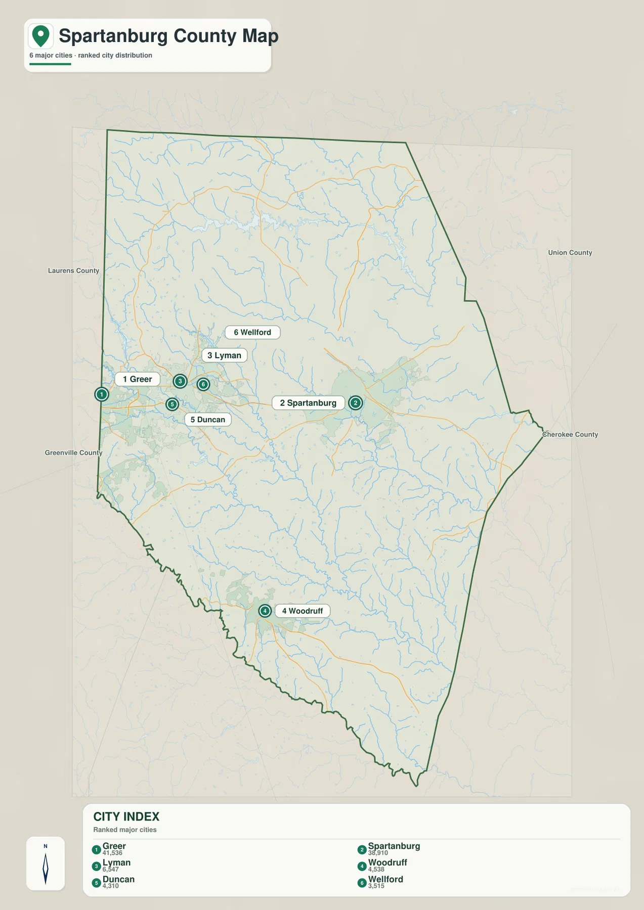
The numbers on this city map are ranking labels, not mileage or travel-time values. To understand an actual route between Greer and Spartanburg, or between Spartanburg and Woodruff, return to the general map and follow the interstate and highway network. The city map is strongest as a quick location tool, while the road map supplies the travel context.
The Pacolet system and Lake William C Bowen define the northern water map
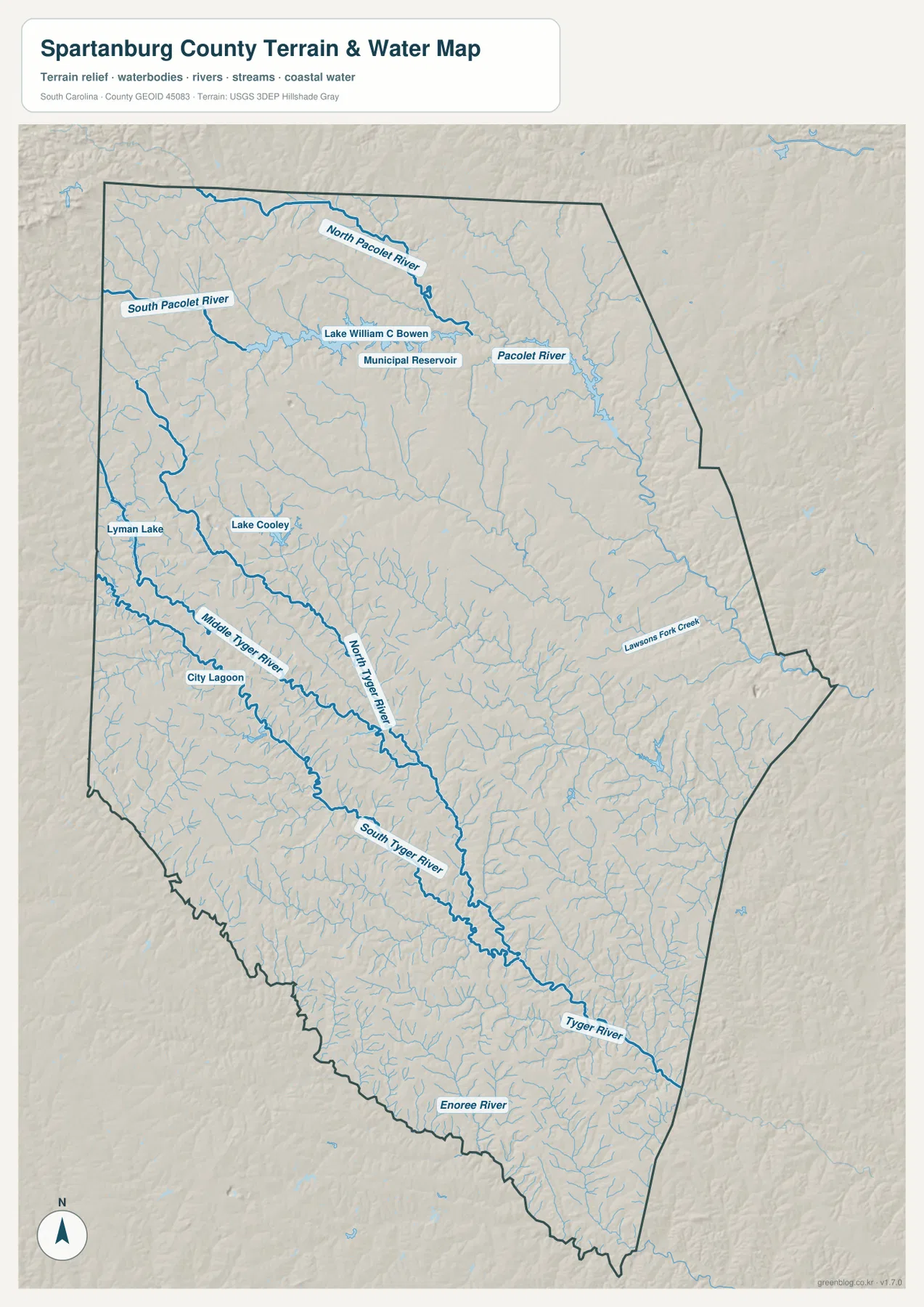
The northern part of the terrain-and-water map is organized around the Pacolet River system. The North Pacolet River and South Pacolet River cross the upper county, and Lake William C Bowen is shown between major branches near the north-central area. A Municipal Reservoir is labeled nearby. These water bodies create a very different set of reference points from the roads and city markers on the other maps.
The Pacolet River continues eastward after the northern branches come together, with many smaller tributaries feeding the system. Relief shading is somewhat more pronounced in the north and northwest than across much of the southern county, so the reservoirs and river valleys stand out against a more textured background. The map is a geographic water reference rather than a flood, navigation, or water-level product.
Three Tyger branches converge across the central and southern county
The middle and southwestern part of the map is dominated by the Tyger River system. Middle Tyger River and North Tyger River descend through the west-central area, while South Tyger River follows a more southerly course. The branches converge farther south and continue as the Tyger River toward the southeastern side of the county.
Lyman Lake and Lake Cooley provide smaller water references in the west, and City Lagoon is labeled close to Middle Tyger River. On the eastern side, Lawsons Fork Creek stands apart from the Tyger branches and helps fill the broad area between the Pacolet and Tyger systems. These named water features make the county easier to divide into meaningful drainage areas without relying on road labels.
The Enoree River frames the south as the terrain becomes gentler
The Enoree River is labeled along the southern boundary, below the Tyger system. Seeing the Tyger River and Enoree River together makes it clear that the southern county is not drained by one single channel. Around Woodruff and the broad southern section, small tributaries cover the map even though the general road map shows fewer major communities than around Spartanburg and Greer.
The shaded terrain appears more textured toward the north and northwest and generally gentler across much of the center and south. This is a relative visual impression rather than an exact elevation measurement. The map should be used to compare the shape of the land and the direction of streams, while exact elevation values require dedicated elevation data.
A practical way to move from a city name to roads, rivers, and lakes
Start with the city map when the question is simply where a place lies. Greer, Lyman, Duncan, and Wellford form the western cluster; Spartanburg is the central reference; Woodruff is farther south. Once the location is clear, the general county map adds I-85, I-26, US 29, US 176, and the smaller state routes.
Use the terrain-and-water map when the question involves rivers, reservoirs, or relief. The Pacolet system and Lake William C Bowen organize the north, the Tyger branches cross the center and south, and the Enoree River forms another strong southern reference. The WebP images on the page are optimized for browser viewing; the ZIP below contains the matching high-resolution A3 JPG originals for larger layouts and printing.
These maps are general geographic references rather than live-traffic, parcel, legal-boundary, flood-risk, or survey products. Road conditions can change, legal boundaries require authoritative records, and the terrain shading does not provide exact spot elevations. Use current official sources whenever a decision depends on those details.
Frequently Asked Questions
Which map is best for comparing Spartanburg with Greer and Woodruff?
The city map is the quickest option. Greer is shown in the western cluster, Spartanburg near the center, and Woodruff well to the south. After locating the cities, use the general map to add I-85, I-26, and the surrounding routes.
Where can I see the Pacolet and Tyger river systems?
They are clearest on the terrain-and-water map. North and South Pacolet River, Lake William C Bowen, and the Pacolet River are prominent in the north. Middle, North, and South Tyger rivers cross the central and southern county before joining the Tyger River, with the Enoree River along the south.
What files are included in the downloadable ZIP?
The ZIP contains three high-resolution A3 JPG files corresponding to the page previews: the general county map, the ranked city map, and the terrain-and-water map. The WebP images in the article are lighter preview files for screen viewing.
Map File Information
Download the Spartanburg County road map, ranked city map, and terrain-and-water map together as high-resolution A3 JPG files.
- Included Files: 3 JPG maps
Related Maps
Sources and Reference Data
- U.S. Census Bureau TIGER/Line Shapefiles: county boundaries, roads, and geographic reference data
- USGS National Hydrography: rivers, streams, lakes, and hydrographic reference data
- USGS 3D Elevation Program: terrain and elevation reference data
- South Carolina Association of Counties: county administrative reference information
Green Map creates custom-edited map images using open geographic data sources such as geoBoundaries, Natural Earth, OpenStreetMap, and government open data.
These maps are edited visual materials, not raw data files, and are provided for education, documents, presentations, and graphic reference.