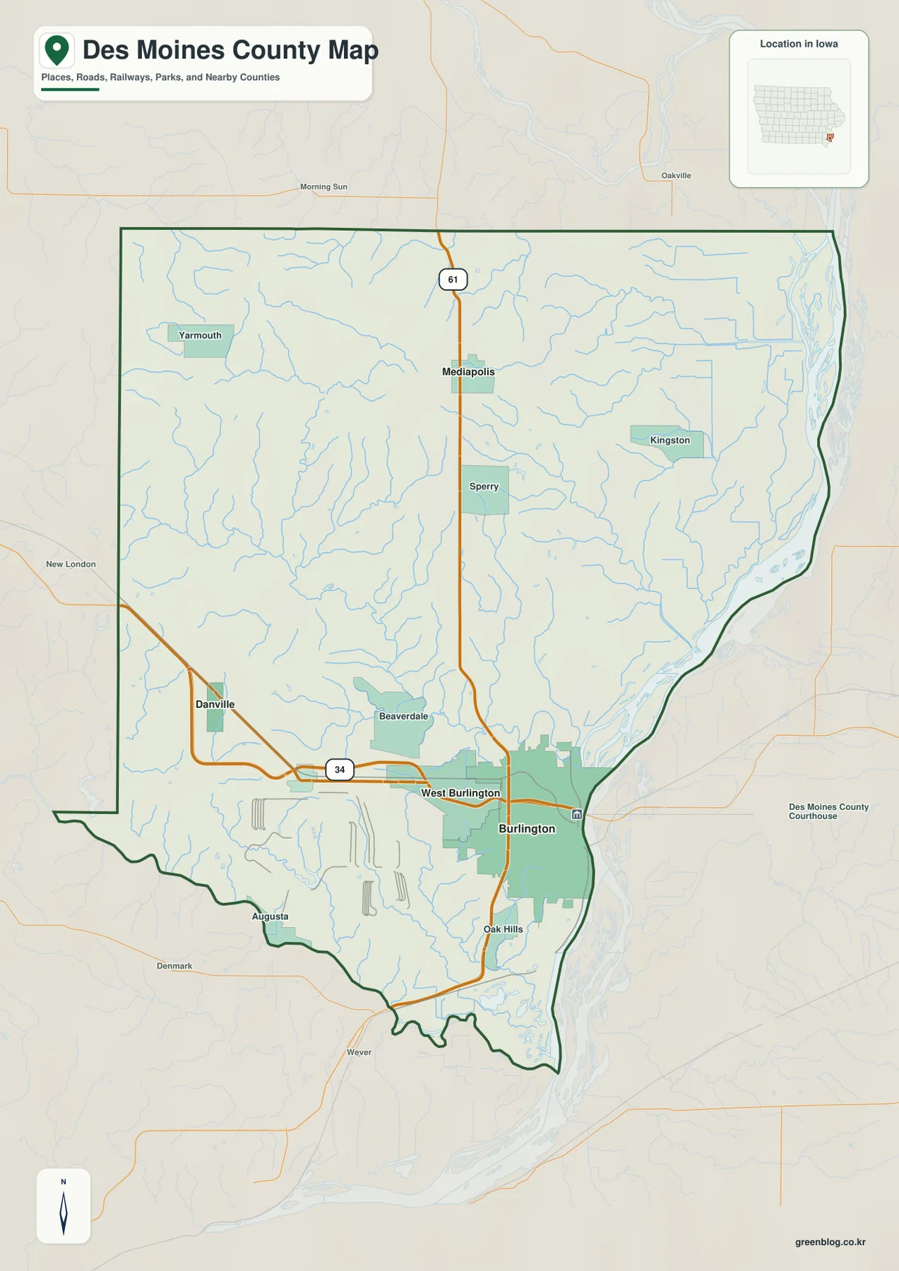
Des Moines County sits in southeastern Iowa along the Mississippi River, centered on Burlington rather than the much better-known city of Des Moines in central Iowa. On the county overview, Burlington and West Burlington form the main urban cluster on the eastern side, U.S. 34 crosses the county from Danville toward the river, and U.S. 61 runs south from Mediapolis through the north-central part of the county. The maps on this page also show the Skunk River along the southern edge, a dense network of interior creeks, and an elevation range of 157 to 255 meters. The WebP images are designed for quick on-page viewing, while the download box below provides the same four map themes as separate high-resolution JPG files in one ZIP archive.
A useful way to read the county is to start at Burlington and then work outward. West Burlington lies immediately to the west, Mediapolis provides a northern reference along U.S. 61, and Danville and Middletown help anchor the western and south-central portions of the map. The terrain becomes lower toward the Mississippi River on the east and the Skunk River on the south, while higher ground is more extensive across the west and northwest. Yellow Spring Creek, Flint Creek, Cedar Fork Creek, Hawkeye Creek, and several smaller streams cut green low corridors into those uplands. Viewing roads, water, and elevation together makes the county much easier to understand than treating the four maps as separate inventories.
Table of Contents
Burlington and the Mississippi River define the eastern side
The eastern edge of Des Moines County is dominated by the Mississippi River, and Burlington occupies the most prominent position along that boundary. The county overview shows a broad Burlington urban area at the river, with West Burlington directly to the west. U.S. 34 approaches from the Danville side, crosses West Burlington, and continues toward Burlington, making it the clearest east–west reference line on the map. U.S. 61 descends from the north through Mediapolis and the Sperry area before reaching the Burlington side of the county. With those two highways and the river in view, most of the county can be oriented quickly.
The elevation map reinforces the importance of the river. A broad band of dark green low ground follows the eastern edge, and smaller low corridors extend inland wherever tributaries approach the Mississippi. Burlington therefore sits not only near the county boundary but also beside the most extensive low terrain shown on the map. This is a generalized terrain view, not a flood-hazard product, so the low colors should not be interpreted as a statement about flood probability, levee protection, or property-level risk. For this page, the elevation shading is used only to show relative relief and the relationship between the river, the city, and nearby uplands.
U.S. 34 and U.S. 61 provide the clearest road framework
Two highways organize the county particularly well. U.S. 34 enters from the west near Danville, runs across the south-central portion of Des Moines County, and reaches the Burlington–West Burlington urban area. U.S. 61 enters from the north, passes Mediapolis, continues near Sperry, and approaches Burlington from the north. The two routes make a useful cross-shaped reference system: U.S. 34 helps compare east and west, while U.S. 61 helps connect the northern communities with the river city. The map is best used for geographic orientation rather than turn-by-turn navigation, because current construction, closures, and routing details can change.
Smaller place labels add context once those highways are located. Yarmouth appears in the northwest, Kingston in the northeast, Beaverdale west of Burlington, and Augusta close to the southwestern edge. Sperry lies between Mediapolis and the Burlington area, while Oak Hills appears south of the main urban cluster. These labels are useful because they occupy different drainage and elevation settings. Following the creeks from the higher western interior toward the Mississippi shows that the county is not a flat rectangle crossed by two roads; it is a landscape of short ridges and branching valleys that the transportation network must cross.
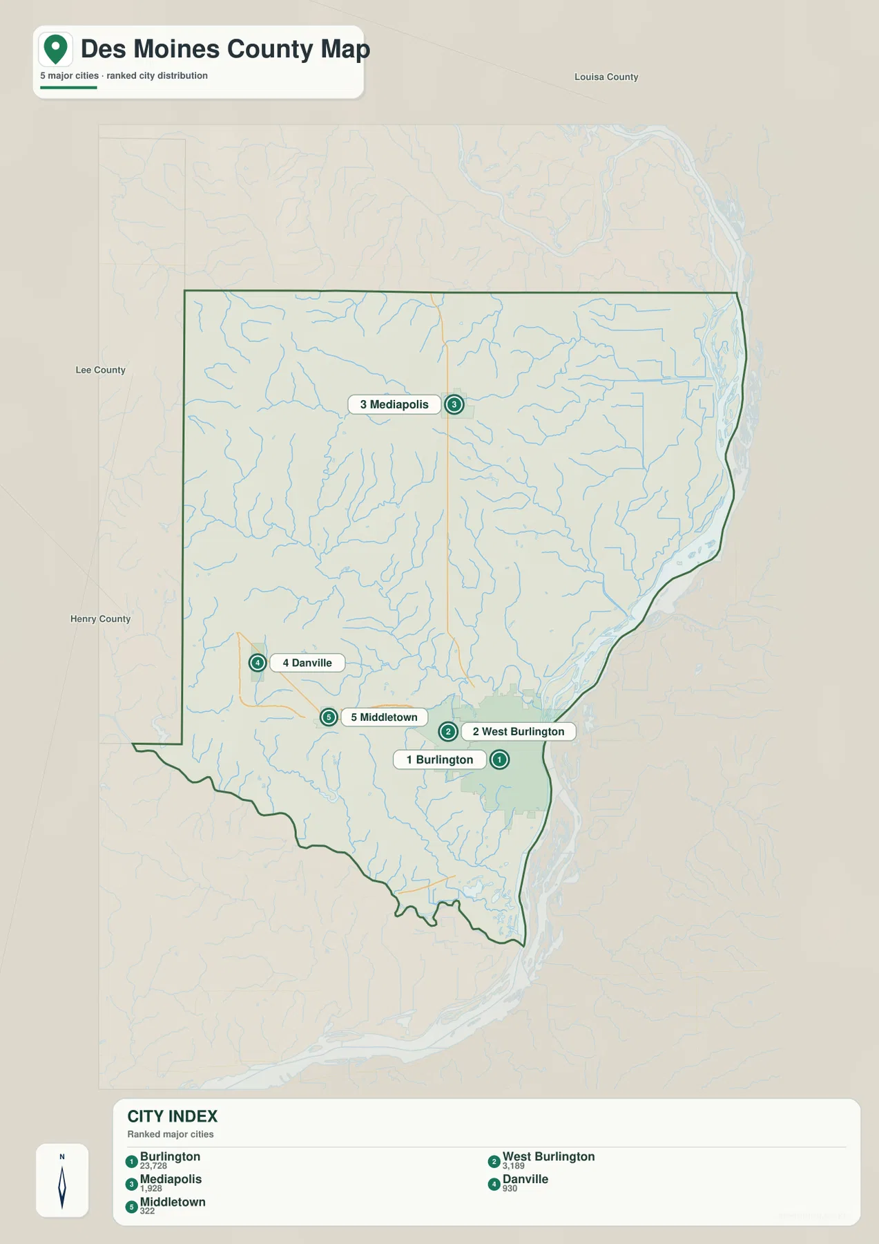
Five highlighted communities from Burlington to Mediapolis
The city map highlights Burlington, West Burlington, Mediapolis, Danville, and Middletown. Its printed city index lists Burlington at 23,728, West Burlington at 3,189, Mediapolis at 1,928, Danville at 930, and Middletown at 322. Those figures are best treated as the values printed on this map rather than as a claim about a particular current population estimate. For geographic purposes, the important point is the pattern: Burlington dominates the eastern river side, West Burlington sits immediately inland, Mediapolis is separated to the north, Danville anchors the west-southwest, and Middletown marks the south-central interior.
The pattern becomes more useful when the road and water maps are compared with it. Burlington and West Burlington are easy to remember with U.S. 34 and the Mississippi River, while Mediapolis is tied to U.S. 61 in the north. Danville sits near the western U.S. 34 approach, and Middletown occupies an interior position between the higher western ground and the lower southern drainage toward the Skunk River. Instead of memorizing five isolated dots, readers can connect each place to a highway, river corridor, or elevation zone and keep the whole county organized mentally.
Creek networks between the Mississippi and Skunk rivers
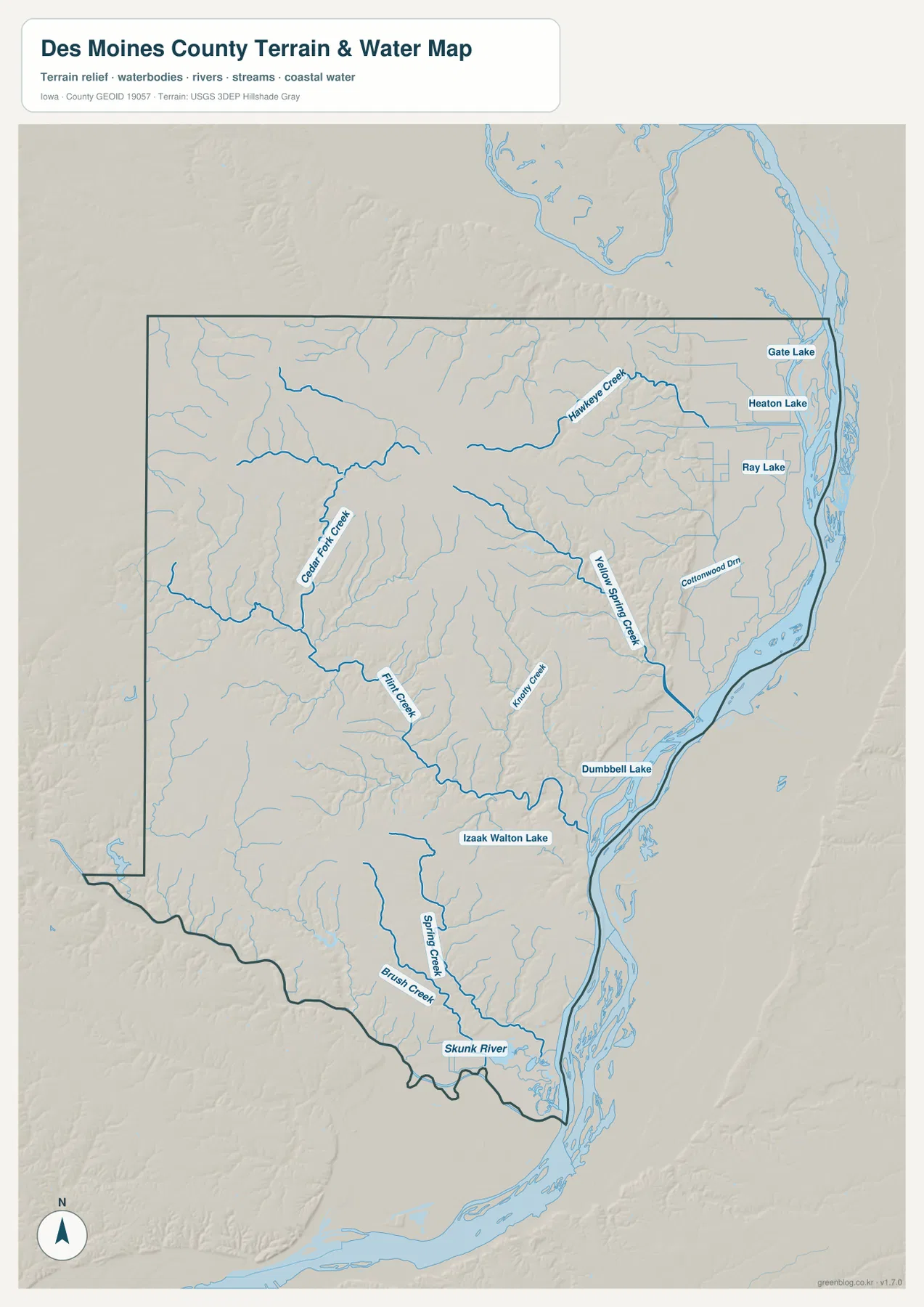
The terrain-and-water map is framed by two much larger rivers. The Mississippi River follows the eastern side of the county, while the Skunk River forms the dominant water feature along the south. Between them, Yellow Spring Creek creates a long interior corridor through the central and southeastern part of the county. Cedar Fork Creek and Flint Creek drain portions of the west and southwest, Hawkeye Creek stands out in the northeast, and Kiley Creek crosses the south-central interior. Spring Creek and Brush Creek approach the Skunk River from the north, while Cottonwood Drain appears near the eastern lowlands.
These waterways explain much of the branching relief on the elevation map. Streams begin in or cut through the higher western and northwestern terrain, then descend toward the Mississippi or the Skunk. Yellow Spring Creek forms one of the longest visible low corridors inside the county. Flint Creek and Cedar Fork Creek divide the western uplands into smaller ridges, and Hawkeye Creek cuts through the northeastern interior before reaching the river side. The water map is useful for relative location and drainage context, but it is not intended for flood prediction, navigation, water depth, parcel boundaries, or legal determinations.
Several lakes provide additional fixed reference points. Gate Lake, Heaton Lake, and Ray Lake appear in the northeastern Mississippi River lowlands. Dumbbell Lake sits farther south along the eastern side, while Izaak Walton Lake is located in the south-central interior north of the Skunk River. These water bodies make the broad eastern lowland easier to read because they show that the river margin is not a single clean line; it contains lakes, side channels, drains, and tributary valleys that occupy a wider low-elevation zone.
157–255 meters: higher west, lower river corridors
The elevation map shows an actual range from about 157 to 255 meters and a mean of 205 meters. The lowest dark green terrain is concentrated along the Mississippi River on the east and the Skunk River on the south. Higher orange and brown terrain is more extensive across the west and northwest. The county therefore has nearly 100 meters of relief from its lowest to highest mapped elevations, but that difference does not occur as one simple slope. Numerous creek valleys cut into the uplands, creating repeated transitions between ridges and lower drainage corridors.
Yellow Spring Creek produces a particularly clear green corridor through the center. Farther west, Cedar Fork Creek and Flint Creek send lower branches into terrain that is otherwise higher. Hawkeye Creek creates another low route in the northeast, and the southern drainages fall toward the Skunk River. Traveling conceptually from Burlington westward therefore means moving from broad river lowland into progressively higher ground, but the rise is interrupted again and again by stream valleys. The terrain map captures this pattern far better than a single average-elevation number can.
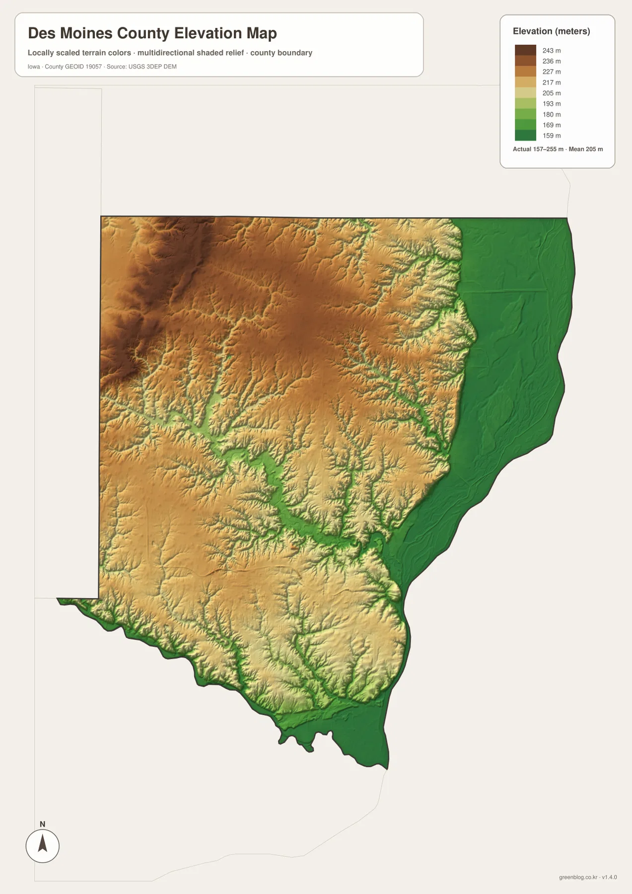
This surface is intended for county-scale comparison, not survey-grade measurement. Elevation can vary within one color band, and road cuts, levees, stream banks, and individual properties may change over short distances that are not visible at this scale. Construction, drainage design, engineering, and parcel-specific work should use original USGS elevation data or professional surveying. For ordinary map reading, the most useful lesson is the relationship between high western ground, branching creeks, and the broad lowlands along the county’s two major rivers.
Following Flint Creek and the south side of Burlington through the relief
Flint Creek is a good example of how the maps complement one another. Start with Burlington and West Burlington on the county overview, then look west toward Beaverdale and Danville. On the water map, Flint Creek descends through the western half of the county toward lower terrain. The elevation map shows a matching green corridor cut into higher orange and tan ground. This comparison makes it clear that roads and settlements sit within a landscape shaped by short ridges and drainage valleys rather than on a uniformly flat surface.
South of Burlington, the low terrain associated with the Mississippi approaches the broader lowland of the Skunk River. Spring Creek and Brush Creek descend toward the southern boundary, and Izaak Walton Lake provides a useful point for comparing the south-central interior with the river edge. Looking at this area across the four maps helps explain why the southern part of the county contains both rolling uplands and wide low corridors. It is one of the best places to see how small tributaries connect the western interior to the larger river systems.
Choosing a map for roads, towns, water, or terrain
For a first look, use the county overview to locate Burlington, West Burlington, Mediapolis, U.S. 34, and U.S. 61. Once that framework is familiar, the city map provides a cleaner comparison of the five highlighted communities without most of the road detail. The terrain-and-water map is the better choice for tracing the Mississippi River, Skunk River, Yellow Spring Creek, Flint Creek, and named lakes. If relief is the main question, the elevation map shows the 157–255 meter range and makes it easy to compare the low green river corridors with higher western ground.
For printing or presentations, selecting one map that matches the topic usually works better than trying to show every layer at once. The overview is strongest for roads and general orientation, the city map for settlement distribution, the water map for drainage and named water features, and the elevation map for ridge-and-valley contrast. The on-page WebP versions are optimized for quick display; the ZIP below contains four separate high-resolution JPG maps suitable for larger viewing, classroom material, presentations, or personal reference. None of the maps replaces legal boundary records, live road information, flood data, navigation charts, or precise survey measurements.
Frequently Asked Questions
Is Des Moines County the same place as the city of Des Moines?
No. This page covers Des Moines County in southeastern Iowa, where Burlington is the main city shown along the Mississippi River. The city of Des Moines, Iowa’s state capital, is a different place in central Iowa. When searching for local information or planning a trip, adding “Burlington” or “Des Moines County” helps avoid that common name confusion.
Which map is best for locating Burlington and Mediapolis together?
Start with the county overview. Burlington and West Burlington are shown along the eastern Mississippi River side, while Mediapolis is farther north on U.S. 61. U.S. 34 also lets you follow the county west toward Danville. After that, the city map is useful when you want a cleaner comparison of the five highlighted communities without most of the road detail.
How should the 157–255 meter elevation range be used?
The map reports a mean elevation of about 205 meters. Lower terrain follows the Mississippi River on the east and the Skunk River on the south, while higher ground is more common in the west and northwest. Creek valleys such as Yellow Spring Creek and Flint Creek cut lower corridors into those uplands. The map is appropriate for regional comparison, but property, engineering, or construction work requires original elevation data or professional surveying.
Map File Information
The ZIP contains high-resolution JPG versions of the Des Moines County overview, major-city, terrain-and-water, and elevation maps.
- Included Files: Use only the versions confirmed in the article and supplied images
- File Type: Use the confirmed download contents
- Intended Use: Printing, education, presentations, and map-based projects
Related Maps
Sources and reference data
The resources below provide official county information and more detailed boundary, hydrography, and elevation data. The maps on this page are simplified for general geographic understanding, so original agency datasets should be used whenever exact geometry, legal status, or precise elevation values matter.
- Des Moines County official website
- Des Moines County Conservation parks and natural areas
- U.S. Census Bureau TIGER/Line Shapefiles
- USGS National Hydrography
- USGS 3D Elevation Program
These maps are general-reference resources for orientation, learning, printing, and presentation use. Legal boundaries, property ownership, current road restrictions, flood hazards, water depth, and precise elevations should always be checked against current records from the responsible agency or an appropriate professional source.
Green Map creates custom-edited map images using open geographic data sources such as geoBoundaries, Natural Earth, OpenStreetMap, and government open data.
These maps are edited visual materials, not raw data files, and are provided for education, documents, presentations, and graphic reference.