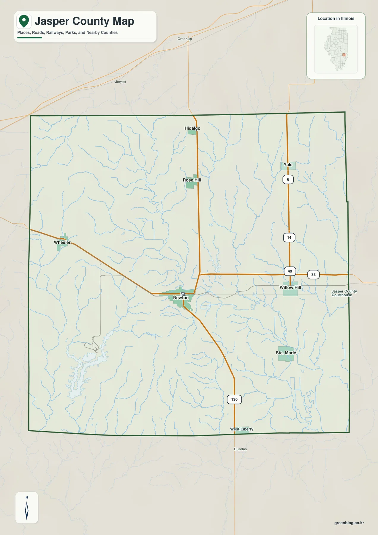
The Jasper County Illinois Map download on this page contains the full-size JPG files behind the four previews below. Newton is the main reference point, Route 130 runs north toward Hidalgo and south toward West Liberty, and the other files add a six-place CITY INDEX, the Embarras River drainage, and relief labeled from 133 to 191 meters. Willow Hill, Ste. Marie, Wheeler, Yale, Rose Hill, and the county’s lakes can then be placed around that Newton-centered framework.
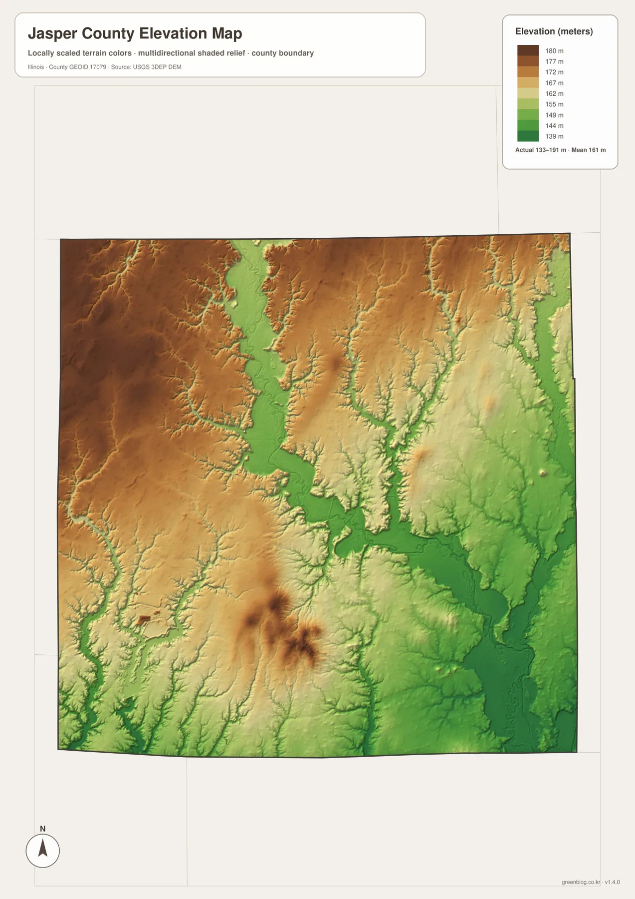
The county changes noticeably across the Embarras River valley. Higher brown terrain occupies much of the west and northwest, while the river corridor and large areas to the east and southeast are lower and greener on the elevation file. A smaller pocket of high ground also appears in the south-central interior. Reading the road, water, and relief files together gives Newton and the surrounding rural communities a clearer geographic setting.
Table of Contents
Route 130 makes Newton the easiest place to start
Newton lies slightly south of the county’s center and is the clearest point from which to orient the general map. Route 130 runs through town, continuing north toward Hidalgo and south toward West Liberty. A road from Newton bends northwest toward Wheeler, while the eastern road network reaches Willow Hill and the county-courthouse label near the east side. With Newton fixed first, Rose Hill, Ste. Marie, and Yale fall into place much more easily.
Willow Hill sits east of Newton near the intersection marked by Route 49 and Route 33. Route 33 forms the stronger east–west reference through this part of the county. Yale is farther north on the eastern side, while Hidalgo stands on the Route 130 line north of Newton. Rose Hill occupies the north-central interior between those larger road references.
Wheeler is positioned close to the western boundary, reached by a road that curves northwest from the Newton area rather than by a straight east–west line. Small streams cross this western side repeatedly. Greenup and Jewett appear north of the county boundary on the background map, while Clay and Richland counties provide outside orientation to the west and southwest.
Jasper County’s official government website places the county offices in Newton, and the county government history identifies Newton as the county seat chosen when Jasper County was created in 1831. That administrative role fits the map well: Newton is also the place where the main road and river references become easiest to connect.
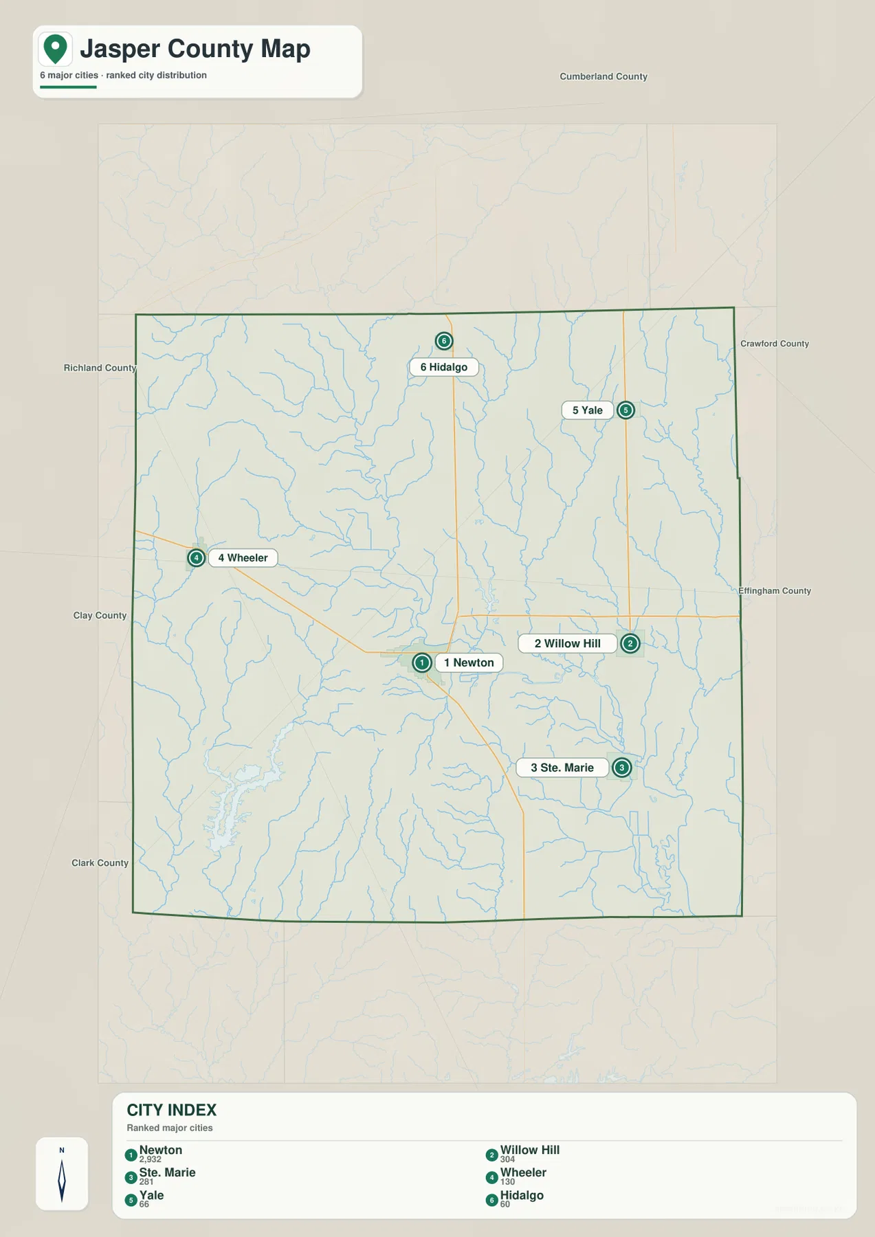
Six CITY INDEX points spread from Wheeler to Yale
The ranked-city file selects six communities. Newton is first at 2,932, Willow Hill is second at 304, and Ste. Marie is third at 281. Wheeler follows at 130, Yale at 66, and Hidalgo at 60. These figures are the values printed on the supplied CITY INDEX and are used here only to explain that layer; they are not presented as current official population estimates.
The geography is more useful than the ranking alone. Newton anchors the lower middle, Willow Hill lies to the east, and Ste. Marie is farther southeast. Wheeler sits near the western boundary, Yale is in the northeast, and Hidalgo marks the north-central Route 130 corridor. Because the points are distributed in several directions, the map gives a quick sense of the county’s width and north–south extent.
Neighboring-county labels provide a broader frame: Cumberland County is north, Crawford and Effingham counties are on the eastern side, Richland and Clay counties lie west, and Clark County appears southwest. Rose Hill and West Liberty are visible on the general map but not in the CITY INDEX, so the two files are meant to be used together rather than as duplicates.
Newton’s county-seat role is also separate from its CITY INDEX number. The government site establishes Newton as the county government center; the ranked layer simply orders six selected places by the values printed on the image. That distinction matters when the file is used in a report or classroom setting.
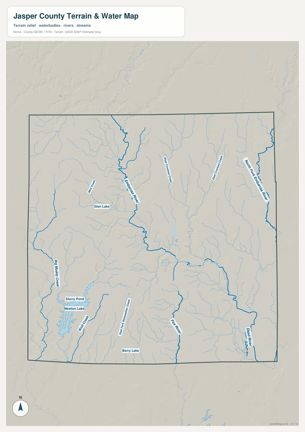
Embarras River links the central valley to Newton and Ste. Marie
The Embarras River is the strongest water reference on the terrain-and-water file. It enters from the north, bends through the central county, and continues past the Newton area toward the southeast. Miller Creek and Big Muddy Creek lie to the west, while West Crooked Creek and East Branch Crooked Creek occupy the eastern half. Those named tributaries give the central river valley a clear structure.
A second major line, the North Fork Embarras River, follows the eastern side of the county. Dead River appears farther south on the east, and Fox River extends through the south-central area. The presence of these separate named channels shows that drainage is not concentrated in one single corridor even though the main Embarras River remains the easiest reference.
The southwestern part of the map contains Newton Lake and Slurry Pond close together, with Wolf Creek nearby. Glen Lake appears farther northwest, and Berry Lake is labeled near the southern interior. These lakes and ponds provide smaller fixed points when the thin tributary lines become difficult to follow.
Illinois DNR places Sam Parr State Fish and Wildlife Area about three miles northeast of Newton and describes a 183-acre lake within the site. The park name is not drawn as a boundary on the supplied county maps, so the IDNR page supplies useful local context rather than a feature to trace directly from the JPG. Current fishing, boating, camping, and access rules should be checked with the agency.
The blue network on this page is a location reference, not a live hydrologic product. It does not show flood probability, current stage, water quality, navigation status, public access, or parcel ownership. Embarras River and its smaller tributaries can change with rainfall and season, so safety or property decisions require current USGS and local information.
A 133–191 meter range separates western high ground from the river valley
The elevation legend prints an actual range of 133–191 meters and a mean of 161 meters. The displayed color scale itself runs from roughly 139 to 180 meters. Brown and tan colors cover much of the west and northwest, while the Embarras River corridor forms a greener low zone through the middle. Large areas of the east and southeast also remain lower than the western uplands.
The river valley is easy to match between the two map types. The main Embarras River descends through a green corridor from the north and continues southeast of Newton, while the North Fork Embarras River follows another lower belt near the eastern edge. Narrow tributary valleys cut into the higher western terrain, producing the more textured pattern visible there.
One feature prevents the county from being described as a simple west-high/east-low slope. A compact area of darker brown relief rises in the south-central interior, surrounded by lower yellow and green terrain. That isolated high ground contrasts with the broader western upland and makes the southern relief more varied than the road map alone suggests.
An Illinois greenways plan for Jasper County describes the county as generally flat but notes distinct hills, cliffs, and stronger topographic change near waterways. It also identifies the Embarras River as the county’s major waterway, entering from Cumberland County, passing toward Newton, then turning southeast toward the Ste. Marie area. That description matches the broad pattern visible on the supplied water and elevation files.
The relief JPG is a county-scale comparison tool, not a survey surface. The 133–191 meter range is appropriate for discussing broad high and low areas but not for certifying parcel elevations, road grades, drainage design, or construction tolerances. USGS 3DEP and professional field measurements are the appropriate sources when precision matters.
Newton connects roads, river terrain, and nearby Sam Parr
Newton is the best place to connect the four files. On the road map it lies on Route 130 and the east–west route system; on the water file it sits close to the Embarras River; on the relief map it occupies the lower central valley rather than the western high ground. Keeping Newton fixed while switching files makes the county’s drainage and road directions much easier to follow.
The southwestern lakes and the Sam Parr area provide two useful contrasts around Newton. Newton Lake and Slurry Pond are shown southwest of the city, while the official IDNR page places Sam Parr to the northeast. Those directions demonstrate that named water and recreation features are not confined to one corner of the county.
South of Newton, Route 130 continues toward West Liberty while Ste. Marie lies farther southeast. The water and elevation files show low valleys mixed with smaller higher areas through this part of the county. Adding relief to the road view helps explain the setting without turning the map into a technical terrain analysis.
Use the file that matches the Jasper County question
For towns and roads, begin with the general county file and use Newton, Route 130, Route 33, Hidalgo, Willow Hill, Ste. Marie, and Wheeler as fixed points. For a simplified comparison of the six selected communities, the CITY INDEX removes most secondary labels and keeps only the ranked points.
For waterways, trace the Embarras River first and then branch to the North Fork Embarras River, Crooked Creek system, Newton Lake, Glen Lake, or Berry Lake. For broad terrain differences, the elevation file immediately separates the western high ground from the central and eastern low zones.
The embedded WebP copies are sized for quick browser viewing. The original JPGs are 2572 × 3638 pixels, giving road numbers and water labels more room when enlarged or printed. They work well in classroom handouts, presentations, county-comparison sheets, and personal reference as long as the original aspect ratio is preserved.
Legal boundaries, parcels, flood studies, navigation, surveying, and engineering require other source products. Census TIGER/Line provides official geographic reference data, USGS National Hydrography provides source water information, and USGS 3DEP provides elevation data. The downloadable files here are designed for orientation and visual comparison.
Full-size Jasper County JPG files
The ZIP contains the general county map, CITY INDEX map, terrain-and-water map, and elevation map at their original JPG dimensions. Opening them separately makes the small labels easier to inspect than in the browser previews, while placing them side by side is useful when a town, creek, or road needs to be compared against the relief surface.
Frequently Asked Questions
Are the CITY INDEX values current official population counts?
No. They are the values printed on the supplied ranked layer: Newton 2,932, Willow Hill 304, Ste. Marie 281, Wheeler 130, Yale 66, and Hidalgo 60. They explain this map’s ordering only. Current official population figures should be checked with the U.S. Census Bureau.
How close is Sam Parr State Fish and Wildlife Area to Newton?
Illinois DNR places Sam Parr State Fish and Wildlife Area about three miles northeast of Newton and describes a 183-acre lake within the site. The county images do not draw the park boundary or facilities, so current IDNR material should be used for entrances, boating, fishing, camping, and other recreation details.
Can the 133–191 meter relief map be used for surveying?
No. The relief surface compares county-wide high and low areas; it does not provide certified point elevations or engineering tolerances. Parcel surveys, construction grades, or drainage design require original elevation data and professional measurement rather than a color readout from this JPG.
Map File Information
The archive contains the Jasper County general map, CITY INDEX map, terrain-and-water map, and elevation map as high-resolution JPG files.
- Included Files: 4 JPG files
- Printable Size: 2572 × 3638 pixels each
Related Maps
Sources and reference data
- Jasper County & Newton, Illinois – Official Government Website: official county and city government information centered on Newton
- Illinois DNR – Sam Parr State Fish and Wildlife Area: official information on the wildlife area northeast of Newton and its 183-acre lake
- U.S. Census Bureau TIGER/Line Shapefiles: official geographic boundary and feature reference data
- USGS National Hydrography: source information for rivers, streams, lakes, and related water features
- USGS 3D Elevation Program: source elevation data when more precision is required than the relief JPG provides
Green Map creates custom-edited map images using open geographic data sources such as geoBoundaries, Natural Earth, OpenStreetMap, and government open data.
These maps are edited visual materials, not raw data files, and are provided for education, documents, presentations, and graphic reference.