Reeves County Map resources on this page show Pecos, Toyah, Balmorhea, the county road network, named waterways, and the strong rise in elevation toward the southwest. High-resolution A3 JPG versions of all four maps are available together in a ZIP download below, so you can use the page for a quick reference and keep the larger files for printing or closer inspection.
Pecos is the easiest place to use as an anchor. It sits east of the county’s center and is surrounded by the most obvious road connections, while Toyah lies to the west and Balmorhea is much farther southwest. That arrangement becomes more meaningful when the city map is compared with the water and elevation maps: the southwestern part of the county is higher, and many of the named creeks and reservoir features are concentrated away from the Pecos River area in the north.
Table of Contents
Start with Pecos and the county outline
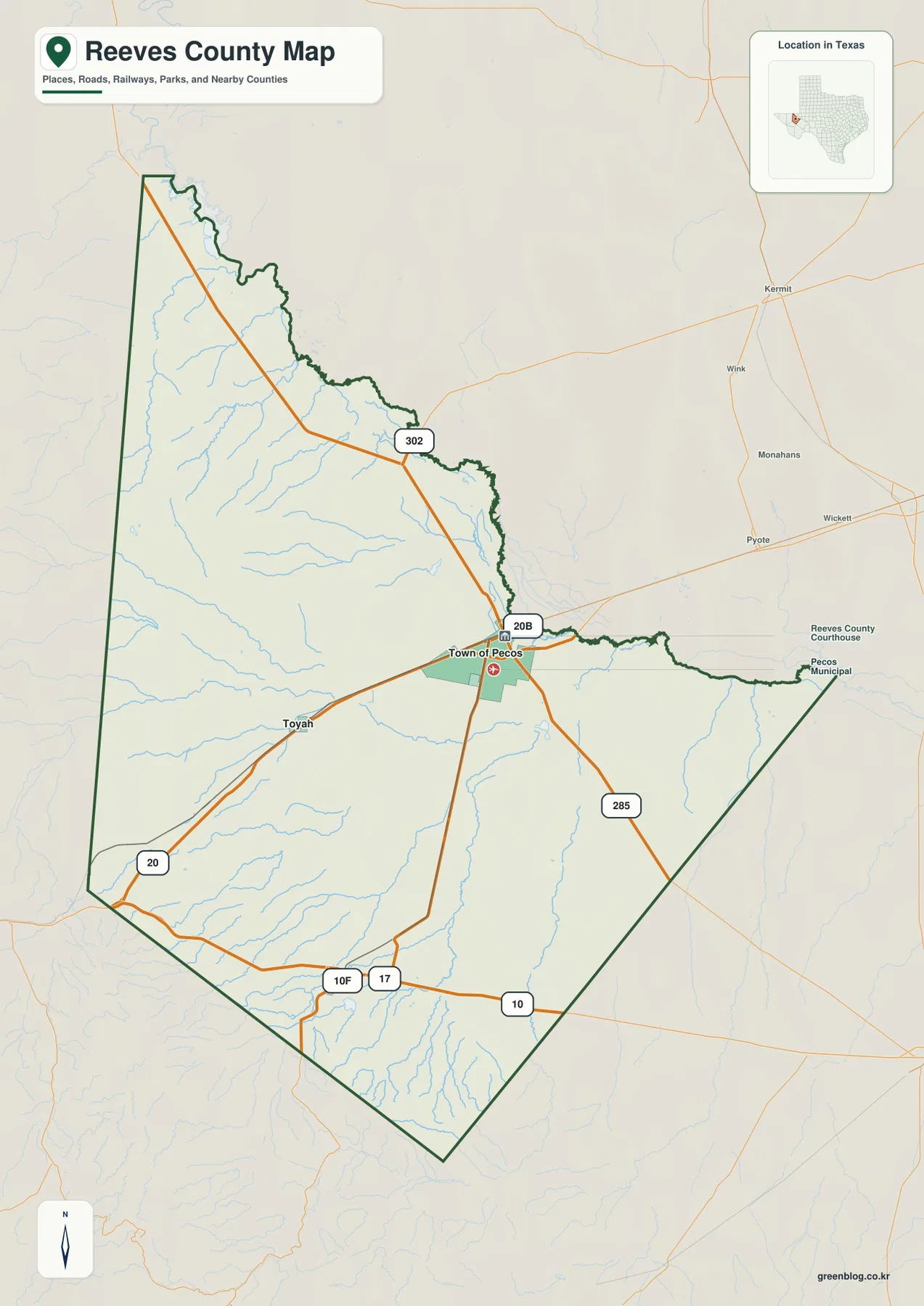
The general county map makes Pecos the clearest reference point. The mapped urban area appears near the east-central part of Reeves County, and several highways converge there before splitting toward the west, northwest, south, and east. Toyah appears west of Pecos on the Interstate 20 corridor, while the county stretches a long distance north and southwest beyond the main city.
The surrounding county labels help orient the shape. Loving County is shown to the north, Ward County and Pecos County are east of Reeves County, and Jeff Davis and Culberson counties are on the western side. This context matters because Pecos is not located in the geometric middle of the county. A large amount of Reeves County extends west and southwest from the city, so the apparent distance to Toyah or Balmorhea is easier to understand when the full boundary is visible.
Roads from Pecos to Toyah and Balmorhea
Interstate 20 is the main east-west route shown through the Pecos–Toyah part of the map. U.S. 285 runs south from Pecos, State Highway 302 heads northwest, and the southern part of the county includes Interstate 10 and State Highway 17 near the Balmorhea side. These routes give the map a useful framework: even before checking smaller features, you can see which direction each named place lies from the county seat.
The city-connections map simplifies that pattern to three labeled places. Town of Pecos is the hub, Toyah is west of it, and Balmorhea is southwest. The direct-distance labels also show that Toyah is the closer of the two outlying places, while Balmorhea sits farther from Pecos. For readers comparing communities rather than individual roads, this version is faster to scan than the more detailed county map.
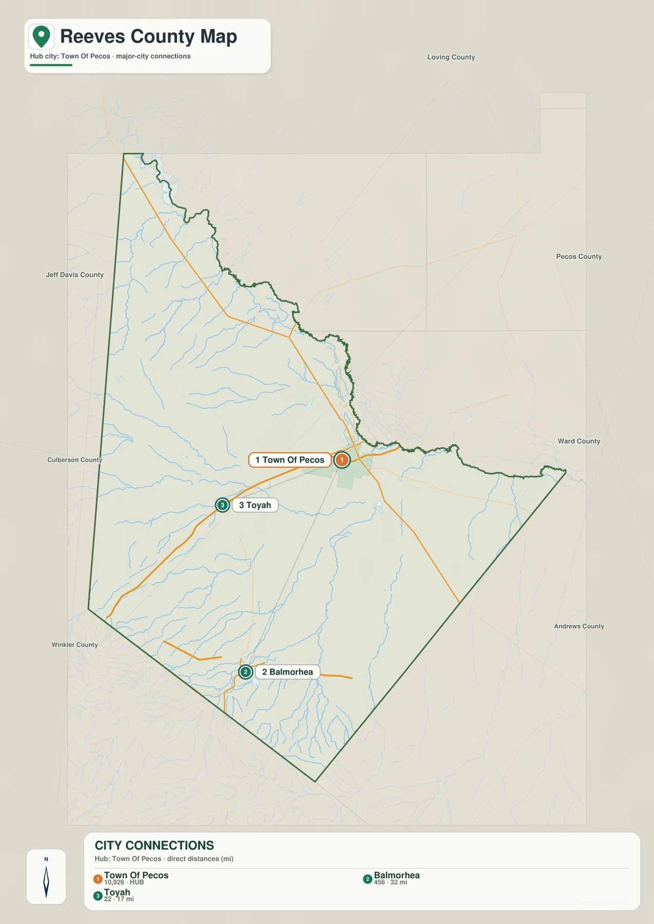
Toyah and Balmorhea should not be treated as points on the same straight route. Toyah follows the westward Interstate 20 direction from Pecos, while Balmorhea is farther south and southwest, closer to the highways shown along the southern edge. That distinction is useful on a printed map because it prevents the county’s long diagonal shape from making the two communities look more closely aligned than they really are.
Pecos River, Toyah Lake, and southern creeks
The terrain-and-water map shifts attention away from highways. Pecos River is labeled near the northern edge of the county, with Salt Creek nearby on the northwest side. Numerous smaller channels extend across the interior. They are less visually dominant than the major roads on the general map, but the water map makes their distribution much easier to see.
Farther south, the map labels Cottonwood Creek, Salt Draw, Toyah Lake, Cherry Creek, Toyah Creek, Sandia Creek, and Lower Parks Reservoir. These features show that the county’s mapped drainage is not represented by one river alone. The southern and southwestern areas contain a network of creeks, draws, canals, and reservoir features that can be compared directly with the higher terrain shown on the elevation map.
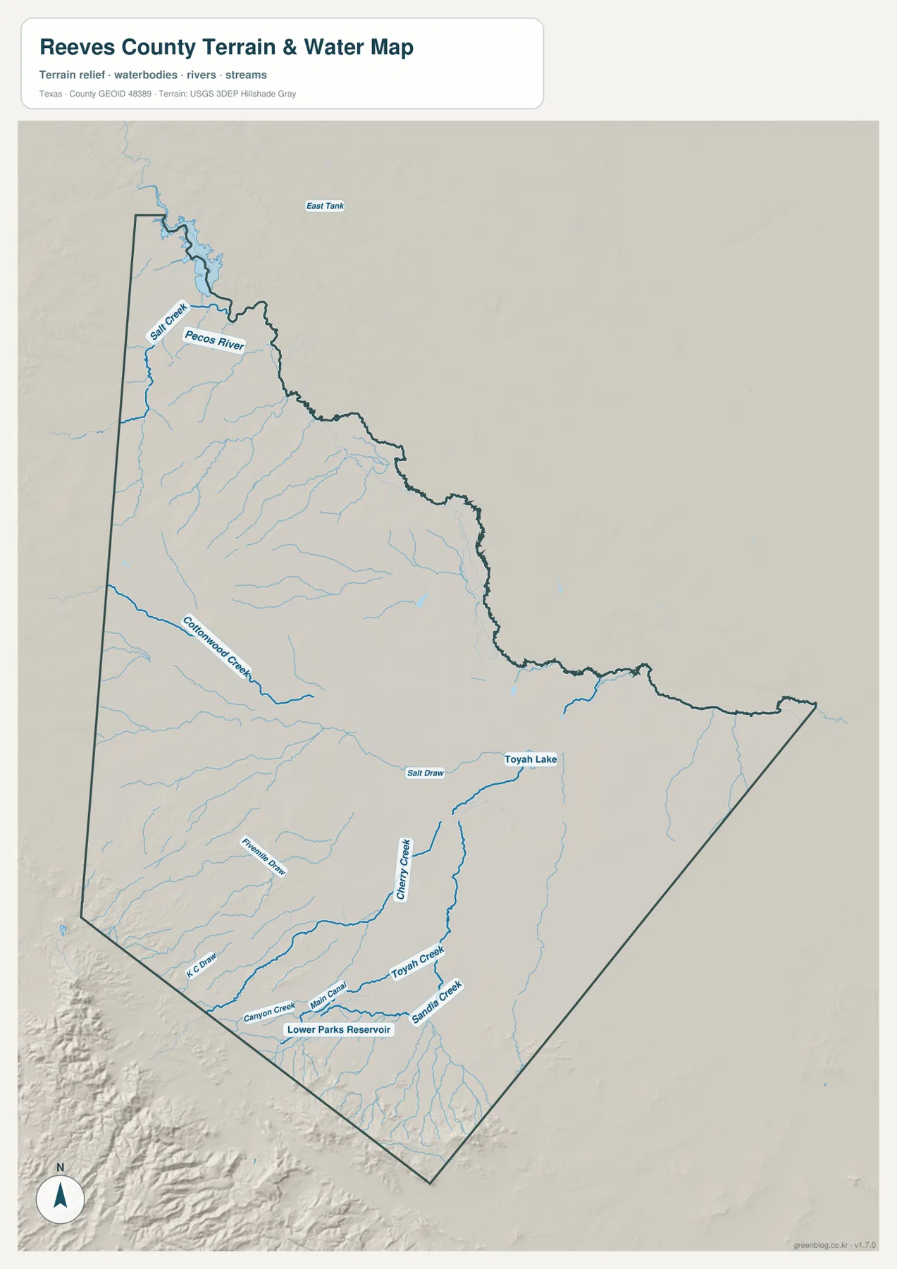
This map is most useful for relative location rather than legal or hydrologic interpretation. If you want to know where a named water feature lies within Reeves County, the labels make that easy. If you need property boundaries, streamflow measurements, or regulatory information, those questions require the appropriate official datasets rather than the blog map itself.
A 748–1,551 m elevation range across Reeves County
The elevation map shows the strongest county-wide contrast. Its legend gives an actual range of 748 to 1,551 meters and a mean elevation of 909 meters. Much of the north and east is colored in lower green tones, while the southwest and parts of the southern boundary shift through yellow and brown into the highest terrain.
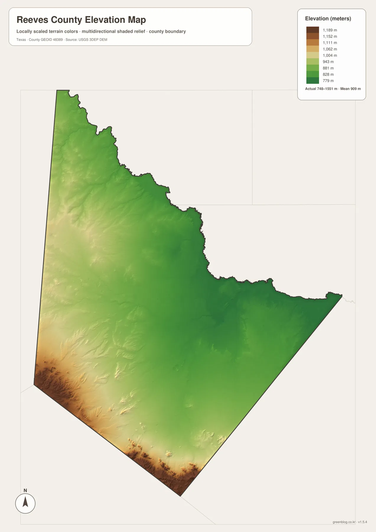
Balmorhea’s position becomes especially clear in this view. The city-connections map places it southwest of Pecos, and the elevation colors rise in the same general direction. Pecos and the broad eastern side sit in comparatively lower terrain. Looking at these maps together explains why a trip across Reeves County can move from a broad lower basin setting toward noticeably higher ground without leaving the county.
What each map is best at showing
The general county map is the best starting point for boundaries, highways, Pecos, and Toyah. The city map removes much of that detail so the relationship among Pecos, Toyah, and Balmorhea can be read quickly. The water map is better for finding names such as Pecos River, Toyah Creek, and Lower Parks Reservoir, while the elevation map replaces most place detail with a clear picture of height differences.
For a practical example, a reader trying to understand the Pecos-to-Balmorhea direction can start with the city map, return to the general map for the highway connections, and then check the elevation map to see the rise toward the southwest. Someone looking for Pecos River can do the reverse: begin with the water map, then use the general map to place the river relative to roads and the county boundary. The maps work better as a set because each one removes some clutter and emphasizes a different type of information.
Using the maps for printing, lessons, and local comparison
For a simple printed reference, the general county map is usually the most useful first page because it combines the county outline, the main roads, and key place labels. In a classroom or presentation, pairing the city map with the elevation map works well: one shows where the communities are, and the other shows how sharply the land rises toward the southwest. The water map is a better choice when a project centers on named streams, draws, or reservoir features.
The downloadable package contains the same four map types shown on this page as high-resolution A3 JPG files. They are bundled into one ZIP so you can keep the larger versions without saving each web image separately. The package includes the county map, city map, terrain-and-water map, and elevation map.
Frequently Asked Questions
Where is Balmorhea compared with Pecos?
Balmorhea is southwest of Pecos. On the city map it is the farther of the two labeled outlying communities, and the elevation map shows that the surrounding southwestern terrain is also much higher than the broad area around Pecos.
Where does Pecos River appear on the Reeves County map?
Pecos River is labeled near the county’s northern edge on the terrain-and-water map. Salt Creek is also labeled nearby on the northwest side, making the northern water features easy to distinguish from Toyah Creek and the other southern waterways.
How much does elevation vary across Reeves County?
The provided elevation map lists an actual range from 748 to 1,551 meters, with a mean of 909 meters. The highest colors are concentrated toward the southwest and southern edge, while lower terrain covers much of the north and east.
Sources and reference data
The Reeves County descriptions above are based on the supplied map assets. The following official resources are useful for checking broader boundary, hydrography, and elevation datasets when you need information beyond the simplified maps on this page.
- U.S. Census Bureau TIGER/Line Shapefiles – official geographic boundary and line data
- USGS National Hydrography – official hydrography and water-feature resources
- USGS 3D Elevation Program – official elevation data and program information
Map File Information
Download the Reeves County county, city, water, and elevation maps as high-resolution A3 JPG files in one ZIP archive.
- Included Files: County map, city map, water map, elevation map
- File Type: ZIP containing 4 JPG files
Related Maps
Green Map creates custom-edited map images using open geographic data sources such as geoBoundaries, Natural Earth, OpenStreetMap, and government open data.
These maps are edited visual materials, not raw data files, and are provided for education, documents, presentations, and graphic reference.