Kent County, Texas becomes much easier to understand once Jayton is used as a reference point rather than treated as the center of the page. Jayton sits close to the eastern side of the county on the supplied maps, while a broad network of local roads, creeks, and higher ground extends far to the west and southwest. The four maps in this package separate those details into a general county view, a city index, a terrain-and-water map, and an elevation map. A high-resolution A3 JPG set containing all four maps is available in the download box below.
The strongest geographic story in the package is not a dense chain of towns. It is the relationship among a small number of named places, the two major Brazos River forks, and a surprisingly large change in elevation. Jayton, Girard, Harmony, and Polar appear on the general map, while the water map adds the White River, Salt Fork Brazos River, Double Mountain Fork Brazos River, several creeks, and small lakes. The elevation map reports an actual range of about 536 to 862 meters with a mean of 644 meters, revealing much more relief than a plain road map suggests.
Table of Contents
Use Jayton as the reference point, not the geometric center
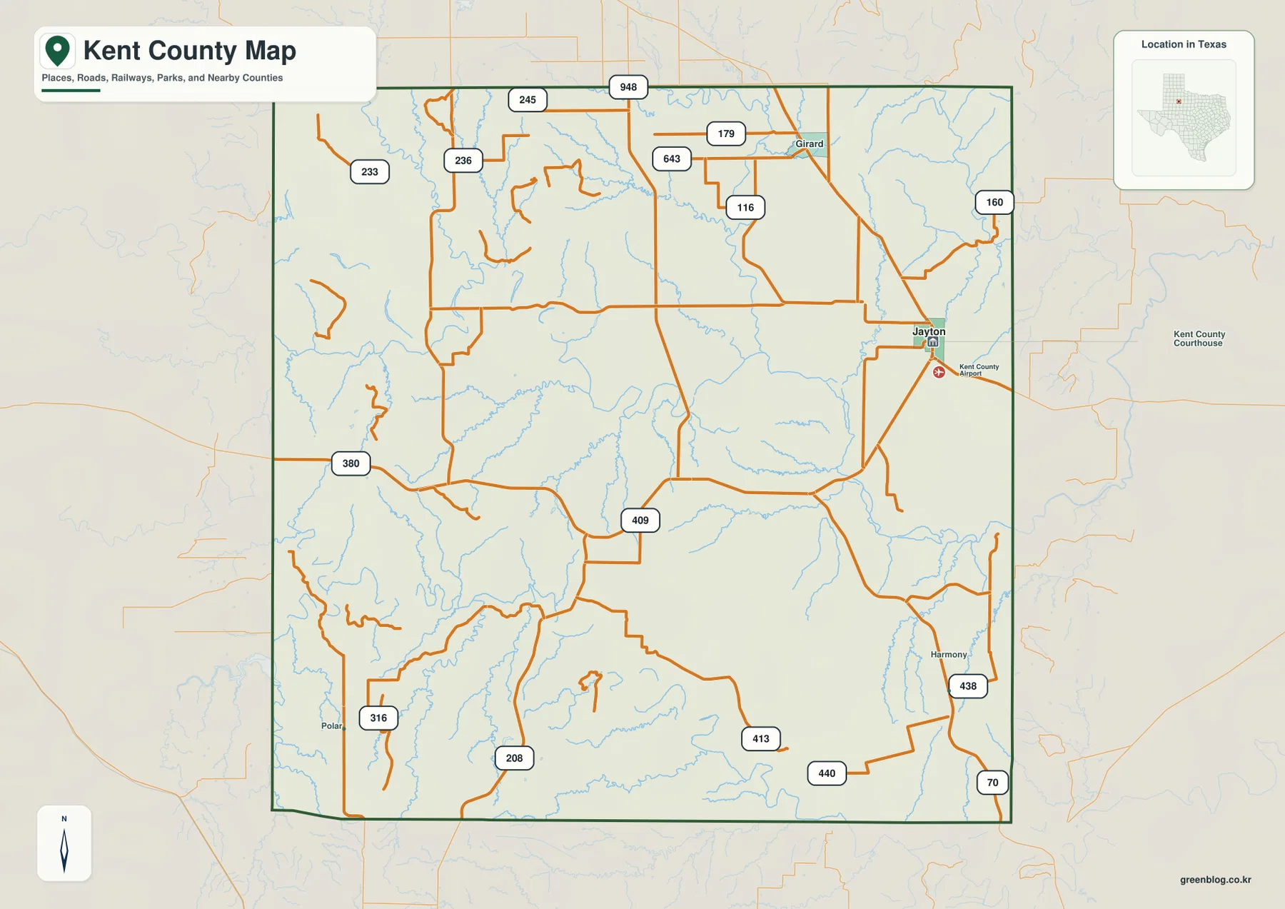
On the county map, Jayton is positioned well toward the eastern side. The courthouse and county airport symbols appear close to it, which makes the town an easy landmark to find before moving outward. Girard is shown to the north, Harmony appears farther south along the eastern side, and Polar is labeled near the southwest edge of the mapped area. The large spaces between those names are as visually important as the labels themselves because they show how little of the county is occupied by a continuous urban pattern.
This placement matters when estimating direction and distance from the map. If Jayton is assumed to be central, the western half of Kent County can seem smaller than it really is. Instead, start at Jayton and trace westward across the road network, then compare that span with the shorter distance to the eastern boundary. The result is a county whose principal mapped town is off-center, with much of the road and drainage detail spread across country to its west.
A few numbered routes provide the clearest orientation
The general map labels Route 380 on the western side and Route 70 near the southeast, along with many smaller numbered roads such as 245, 948, 233, 236, 179, 643, 116, 160, 409, 316, 208, 413, 440, and 438. Those numbers are more useful as location markers than as a list to memorize. The important pattern is that several roads converge near Jayton, while the western and southern parts of the county contain longer stretches between junctions.
Road shape also changes across the map. In parts of the west, routes make short bends and irregular turns among many small drainage lines. Across more open central and southern areas, some connections remain straighter for longer distances. That contrast becomes clearer after looking at the water and elevation maps, where creek valleys and rougher terrain help explain why a simple grid is not the only pattern visible on the ground.
The city index emphasizes just one major center
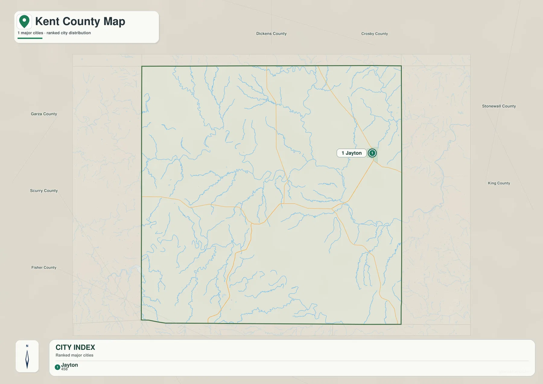
The city map is intentionally sparse. Its ranked city index identifies Jayton as the single major city included in the package, and the large county outline contains no competing urban markers of similar prominence. Around the outside, labels such as Dickens County, Garza County, Scurry County, Fisher County, Stonewall County, and King County provide regional orientation. The effect is very different from a metropolitan county map filled with overlapping city names.
For this reason, the city map is most useful for understanding settlement concentration rather than for comparing many municipalities. Jayton lies near the east side, leaving broad areas to the west, north, and south without a ranked city marker. When the city map is placed beside the general map, smaller place names such as Girard, Harmony, and Polar can be understood as part of the wider county geography without being mistaken for similarly sized urban centers.
The Brazos headwaters appear as distinct forks and tributaries
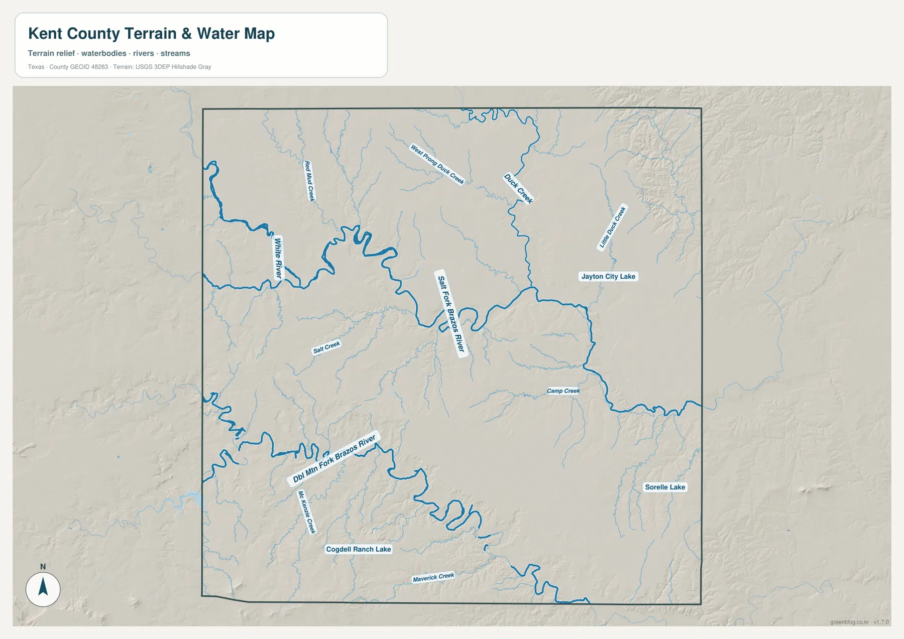
The terrain-and-water map gives Kent County a much stronger identity than the road map alone. The Salt Fork Brazos River curves through the central part of the county, while the Double Mountain Fork Brazos River crosses the southern half in a broad, winding course. The White River is labeled along the western side. Together these named waterways show that the phrase “Brazos River headwaters” describes a network of separate upstream channels rather than one simple river line.
Smaller features fill in the network. Duck Creek and West Pond Duck Creek are marked in the north, White Duck Creek appears toward the northeast, Salt Creek lies farther west, and Camp Creek extends across the central-eastern area. McKenzie Creek and Maverick Creek are labeled in the south. The map also identifies Jayton City Lake, Cogdell Ranch Lake, and Sorelle Lake. These names are useful when a location is too small to stand out on the general county map but still needs to be matched to a drainage or nearby road.
Elevation falls from western uplands into the river valleys
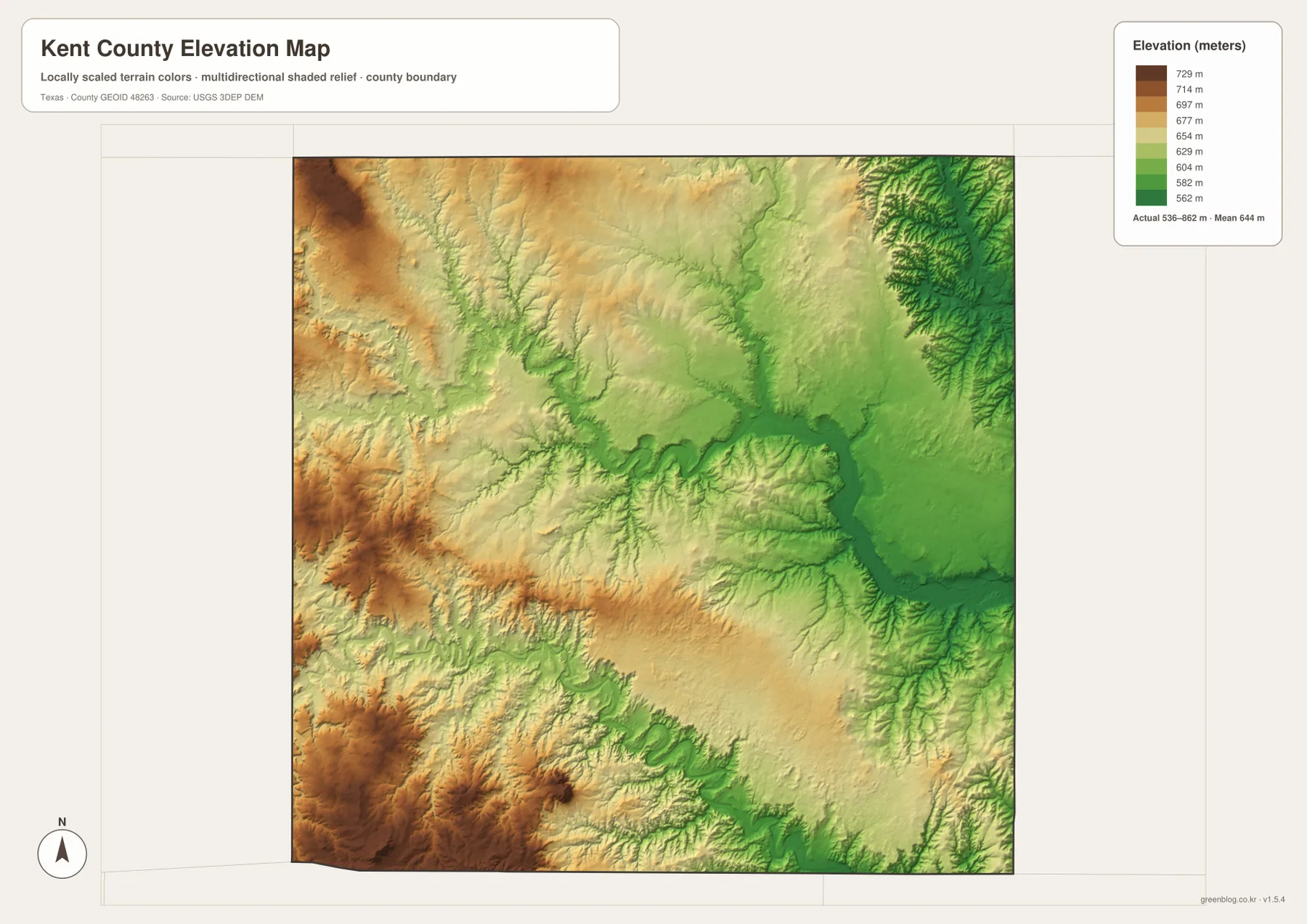
The elevation map reports an actual range of roughly 536 to 862 meters and a mean elevation of 644 meters. Higher terrain appears most strongly in the west and southwest in brown and tan shades. Lower green areas follow the major valleys through the center and east. This makes the Salt Fork and Double Mountain Fork easy to recognize even when the water labels are removed, because their courses are traced by lower ground.
The difference between the minimum and maximum is more than 300 meters, so Kent County should not be pictured as a perfectly flat plain. The southwest contains broad areas of higher, more textured relief, and the western edge also rises above much of the interior. By contrast, the deeply cut drainage corridors create lower passages through the county. The shaded relief adds small ridges and branching gullies that are difficult to see on the simplified road map.
The maps are most informative when the same location is checked twice
A practical way to use the set is to find a place on the general map and then locate the same area on one specialized map. Jayton, for example, is immediately obvious on the city map. On the water map, the nearby Jayton City Lake and the surrounding drainage become easier to see. On the elevation map, the town sits within the lower eastern side of the county rather than among the higher western terrain. Repeating that process turns four separate images into one connected geographic picture.
The same method works in the north and west. Locate Girard on the general map, then move to the northern part of the water map where Duck Creek and West Pond Duck Creek are labeled. Farther west, the White River and numerous smaller tributaries can be compared with the broken road pattern. In the south, the Double Mountain Fork and nearby creeks correspond with a long low corridor on the elevation map. These matches are more useful than treating every map as a standalone illustration.
Choose the file according to the question you need to answer
Use the general county map when you need roads, place names, the county boundary, and a quick overview on one page. The city map is the cleanest choice when Jayton’s position is the main point. The terrain-and-water map is better for the White River, Brazos forks, creeks, and lakes, while the elevation map is the clearest source for distinguishing the western uplands from lower drainage corridors. The maps cover the same county, but each removes some clutter so a particular type of information stands out.
The downloadable archive contains four high-resolution A3 JPG files, making it useful when a larger print is needed than the web preview provides. For teaching or research, the general map can establish location first and the water or elevation map can support a more focused discussion afterward. For travel or field use, these files should be treated as geographic reference maps rather than live navigation products, because road access and current conditions may change independently of the static map package.
Frequently Asked Questions
What is the easiest place to find first on a Kent County map?
Jayton is the best starting point. It is prominent on both the general and city maps and sits close to the eastern side of the county, making it a convenient reference for locating Girard, Harmony, Route 380, Route 70, and the wider western half of Kent County.
Which Brazos River features are actually labeled in the package?
The terrain-and-water map labels the Salt Fork Brazos River and the Double Mountain Fork Brazos River as major channels. It also shows the White River and several smaller creeks, so the headwaters can be viewed as a branching system rather than a single river line.
How much elevation change is shown across Kent County?
The elevation map lists an actual range of about 536 to 862 meters, with a mean of 644 meters. Higher ground is most evident in the west and southwest, while lower terrain follows the major river valleys toward the central and eastern parts of the county.
Sources and Reference Data
For additional boundary and base-map reference, see the U.S. Census Bureau TIGER/Line Shapefiles and USGS The National Map Viewer. Water features can be checked through USGS National Hydrography, while elevation data are available from the USGS 3D Elevation Program.
Map File Information
The ZIP contains four high-resolution A3 JPG files for Kent County: county, city, terrain and water, and elevation maps.
- File Type: JPG
Related Maps
- Scurry County Texas map
- Stonewall County Texas map
- Motley County Texas map
- Taylor County Texas map
- Swisher County Texas map
Green Map creates custom-edited map images using open geographic data sources such as geoBoundaries, Natural Earth, OpenStreetMap, and government open data.
These maps are edited visual materials, not raw data files, and are provided for education, documents, presentations, and graphic reference.