Kenedy County occupies a long stretch of the South Texas Gulf Coast, and its map looks very different from a county built around several closely spaced towns. Sarita sits near the northwestern side of the county, U.S. 77 runs north to south through the western interior, and the eastern edge opens into Laguna Madre and a narrow barrier-island strip. Those three features provide an easy starting point for understanding a county with very sparse settlement and a large coastal landscape.
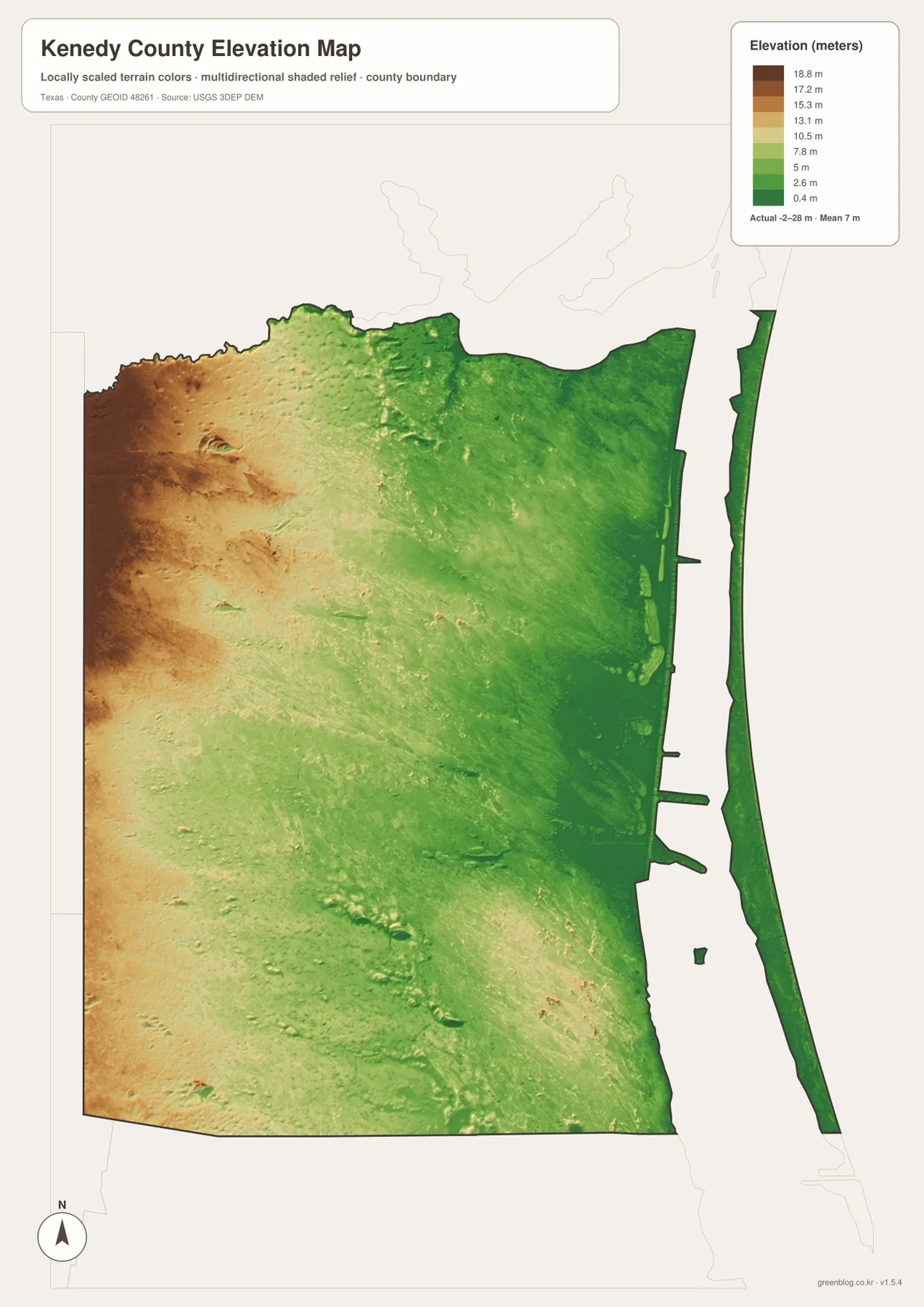
This page includes a county-and-roads map, a terrain and water map, and an elevation map. The WebP versions are placed in the article for quick viewing, while the download box below provides matching high-resolution A3 JPG files in one ZIP archive. The three maps are useful for different tasks: locating Sarita and the main roads, identifying bays and inland water features, or comparing the slightly higher western interior with the very low coastal plain.
The most striking contrast is between the broad inland portion of Kenedy County and the water-dominated eastern side. A road map makes the interior look open and lightly developed, while the water map reveals how much of the coastal edge is shaped by Baffin Bay, Laguna Madre, marshy lowlands, and small lakes. The elevation map adds another piece of the picture by showing that this is an exceptionally low county, with an average elevation of only about 7 meters in the supplied dataset.
Table of Contents
Start with Sarita and the U.S. 77 Corridor
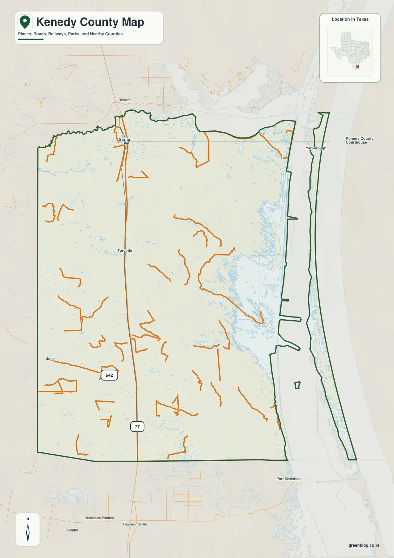
Sarita is the clearest place label to use as an anchor on the county map. It lies close to the northern part of the western interior, directly beside U.S. 77, which continues toward Riviera to the north and the Raymondville area to the south. Because there are few major through-roads inside such a large county, finding U.S. 77 first gives the reader a reliable north-south reference before looking at the more lightly mapped interior roads.
Other labels on the supplied map include Turcotte south of Sarita, Julian farther southwest, and Yarbrough near the coastal side. Route 642 appears near the western boundary, while many of the smaller orange road lines end within the interior rather than forming a dense east-west network. That sparse pattern is one of the most useful things the map communicates. It also means this map should not be treated as a current routing or access guide; anyone planning a drive should confirm present road conditions and legal access separately.
A Large County with Very Few Settlement Labels
Kenedy County is easier to understand when the empty space on the map is treated as information rather than as missing detail. Sarita is the county seat and the most prominent community, but large portions of the county contain no dense cluster of street lines or town labels. The Handbook of Texas entry for Kenedy County also identifies small communities such as Armstrong, Turcotte, Norias, and Rudolph, reinforcing the picture of a county where settlements are widely separated rather than forming a continuous urban corridor.
The county’s outline adds to that unusual appearance. The mainland portion is broad and elongated, while a narrow strip on the Gulf side is separated from the interior by Laguna Madre. When those pieces are viewed together, the map is not simply a diagram of one inland block. It combines South Texas ranch country, coastal wetlands and shallow water, and a barrier-island section within the same county boundary.
Baffin Bay and Laguna Madre Define the Eastern Side
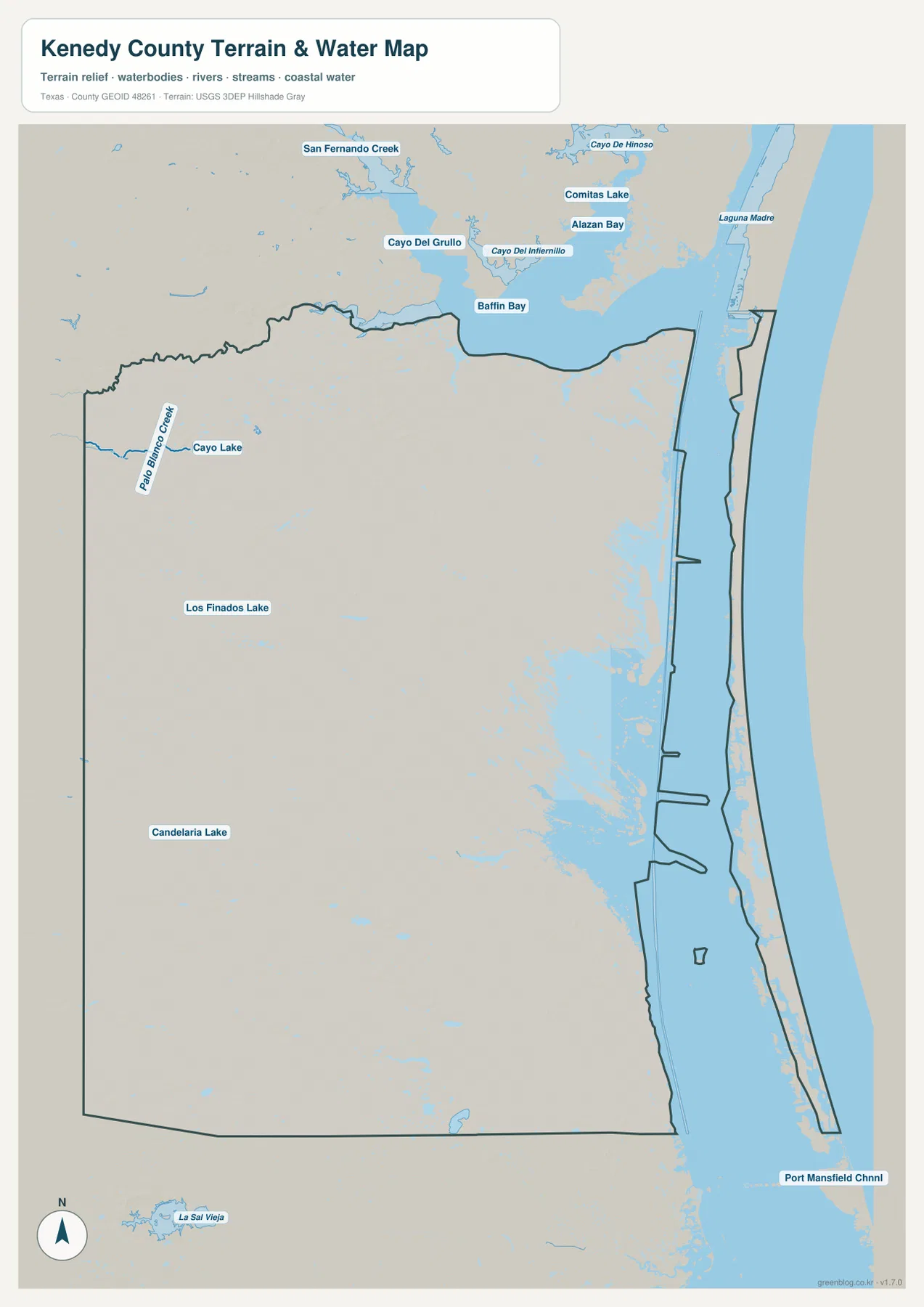
The terrain and water map gives the eastern half of Kenedy County much more definition than the road map alone. Baffin Bay is the dominant named water body near the northeastern boundary, and Laguna Madre extends southward between the mainland and the outer coastal strip. The broad blue areas and wetland-like patches show why the eastern side cannot be understood simply as a conventional shoreline with roads running close to the coast.
Several smaller water features appear farther inland. Palo Blanco Creek and Cayo Lake are labeled in the northwest, Los Finados Lake appears near the middle of the county, and Candelaria Lake lies farther south. The wider map also labels Cayo del Grullo, Cayo del Infiernillo, Comitas Lake, and Alazan Bay around the Baffin Bay area. Some of those features lie outside the county line, so the boundary should be checked before assuming that every label belongs inside Kenedy County. Port Mansfield Channel is shown beyond the southern end and provides a useful reference for how Laguna Madre continues down the coast.
Elevation Ranges from About -2 to 28 Meters
The supplied elevation map reports an actual range of roughly -2 to 28 meters and a mean elevation of about 7 meters. That is a small vertical range for such a large county. The western side contains more tan and brown shading, indicating the relatively higher ground, while green colors become more widespread toward Laguna Madre and the Gulf side. The map therefore shows a broad coastal plain with gentle changes in height rather than mountains, escarpments, or deep interior valleys.
The eastern mainland and the narrow outer strip are especially low. In places the generalized elevation surface falls near or slightly below zero, while the highest mapped areas remain only a few dozen meters above sea level. These values are useful for comparing broad terrain across the county, but they are not survey-grade measurements for a parcel, building site, drainage project, or engineering design. The map is best used to see the overall west-to-east decline and the close relationship between low relief and the coastal water system.
What Changes When the Three Maps Are Compared
Sarita provides a good example of why the maps work better together. On the county map, the important facts are its position beside U.S. 77 and its location in the western part of the county. The water map shifts attention eastward, where much larger areas are occupied by shallow coastal water and wet lowlands. The elevation map then shows that the inland side around the highway is generally higher than the coast, even though the county as a whole remains very low.
The same comparison is even more useful along Laguna Madre. The county map establishes the administrative shape and the narrow outer strip. The water map explains the large separation between that strip and the mainland, while the elevation map confirms that the surrounding terrain is among the lowest in the county. If a reader only needs roads and boundaries, the first map is the clearest choice. For coastal geography or water features, the second map carries much more information, and the elevation map is the best option when the question is about relief rather than place names.
Connections to Kleberg, Brooks, Hidalgo, and Willacy Counties
Kenedy County sits between several recognizable South Texas areas. Kleberg County borders it to the north, Brooks and Hidalgo Counties are on the western side, and Willacy County lies to the south. U.S. 77 continues beyond the county line in both directions, so the highway map makes more sense when it is read as part of a longer route through South Texas rather than as a road that begins and ends inside Kenedy County. Along the eastern side, the stronger regional connection is geographic: Laguna Madre continues well beyond the county boundary.
Those neighboring relationships are useful for orientation, but the maps on this page have a limited purpose. They are not parcel maps, legal-access maps, wetland determinations, flood maps, or marine navigation charts. Large ranches, coastal wetlands, and lightly roaded areas can have access restrictions that are not visible here. For travel or field work, the map should be paired with current road information and any site-specific access rules.
Choosing the Best File for Printing or Class Use
Use the county map when the main goal is to show Sarita, U.S. 77, the county outline, and the limited internal road network. Choose the water map for Baffin Bay, Laguna Madre, Palo Blanco Creek, or the smaller inland lakes. The elevation map is most useful for explaining how a county that appears almost flat still has a measurable difference between the western interior and the coast.
The downloadable archive contains three A3 high-resolution JPG files corresponding to the maps displayed in the article. The larger originals are better suited to printouts, presentations, worksheets, and cropped detail views than the smaller on-page WebP images.
Frequently Asked Questions
Where should I start when reading a Kenedy County map?
Locate Sarita and U.S. 77 first, then move east to Laguna Madre. After those reference points are clear, Baffin Bay and the narrow coastal strip make the county’s shape much easier to understand.
Which water features stand out most on the supplied map?
Baffin Bay and Laguna Madre dominate the eastern side. The map also labels Palo Blanco Creek, Cayo Lake, Los Finados Lake, and Candelaria Lake, along with several named water bodies around the Baffin Bay area.
How high is Kenedy County on the elevation map?
The supplied elevation map reports an actual range of about -2 to 28 meters and a mean near 7 meters. The western interior is relatively higher, while the Laguna Madre side is lower and much closer to sea level.
Map File Information
A ZIP archive containing high-resolution A3 JPG versions of the Kenedy County map, terrain and water map, and elevation map.
- File Type: ZIP containing 3 JPG files
Related Maps
- Willacy County Texas map
- Starr County
- Webb County Texas map
- Zapata County Texas map
- San Patricio County Texas map
Sources and Further Reference
For county background and settlement history, see the Handbook of Texas entry for Kenedy County. Administrative boundary data are available through the U.S. Census Bureau TIGER/Line files.
Water features can be checked through USGS National Hydrography, and broad elevation data are provided through the USGS 3D Elevation Program. The USGS National Map Viewer is also useful for comparing multiple geographic layers in one place.
Green Map creates custom-edited map images using open geographic data sources such as geoBoundaries, Natural Earth, OpenStreetMap, and government open data.
These maps are edited visual materials, not raw data files, and are provided for education, documents, presentations, and graphic reference.