Kendall County sits in the Texas Hill Country northwest of San Antonio, and its map makes more sense when the roads, streams, and relief are viewed together. Boerne is the clearest starting point in the southern part of the county. From there, Interstate 10 runs northwest toward Comfort, while State Highway 46 heads east. The surrounding terrain is far from flat: narrow creek valleys cut through higher ridges, and the Guadalupe River crosses the middle of the county in a broad, winding course.
This page provides four map views built from the supplied Kendall County assets: a county map with roads and places, a city-distribution map, a terrain-and-water map, and an elevation map. The WebP versions are placed in the article for quick viewing. A ZIP download below contains the matching four high-resolution A3 JPG files for printing, classroom use, regional reference, or side-by-side comparison.
The maps show a county with a strong north-south contrast. Boerne and Fair Oaks Ranch occupy the more accessible southern side, while the northern and western parts contain more pronounced Hill Country relief. The Guadalupe River, Blanco River system, Cibolo Creek, and many smaller tributaries help explain why low corridors weave between higher ridges. On the elevation map, that contrast appears as a range of roughly 308 to 634 meters, with a mapped mean of 474 meters.
Table of Contents
Boerne, Comfort and the Road Pattern Across Kendall County
The general county map places Boerne near the southern edge of Kendall County and Comfort close to the northwestern side. Fair Oaks Ranch appears southeast of Boerne near the county boundary. This arrangement is useful because the three places point toward different parts of the county rather than forming a single cluster. Boerne is also identified with public facilities such as the Kendall County emergency medical service and the Boerne Police Department, reinforcing its role as the main civic reference on this map.
Interstate 10 is the dominant long-distance route shown inside the county. It enters near Comfort, bends southeast through the interior, and continues through Boerne toward the San Antonio side of the region. The map also marks Route 87 along the same general corridor, State Highway 46 running east from Boerne, and FM 475 near the southwest. These lines provide a practical framework for locating the smaller streams and terrain features that fill the rest of the county.
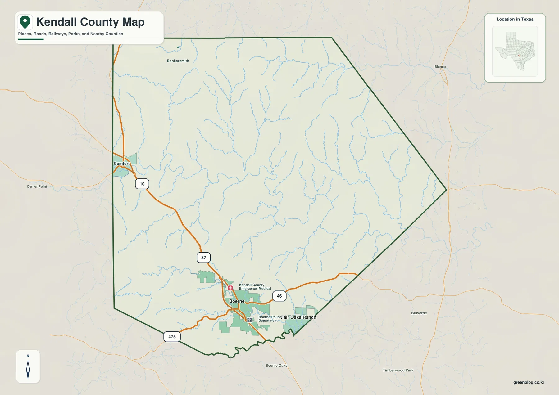
The boundary should be read as an administrative outline rather than as a wall around travel or natural systems. I-10 continues toward Kerr County and San Antonio, while the creek and river network extends beyond the county line in several directions. For trip planning, the map is a geographic overview rather than a substitute for current navigation, road-closure, or traffic information.
Why Boerne Dominates the City-Distribution View
The city map has a narrower purpose than the county map. Instead of labeling every community, it ranks major cities from the available city data. Boerne is the prominent ranked city in the supplied image, so the map immediately emphasizes how strongly the county’s urban center is concentrated in the south. That makes it a useful complement to the general map, where Comfort and Fair Oaks Ranch can also be seen as geographic reference points.
The broader frame labels Kerr and Bandera counties to the west, Bexar County to the south, Blanco and Gillespie counties to the north, and Comal County to the east. Those surrounding labels help explain why Boerne is not simply the center of a closed county system. Its southern location puts it closer to the San Antonio side of the Hill Country, while Comfort provides a useful reference toward the Kerr County direction.
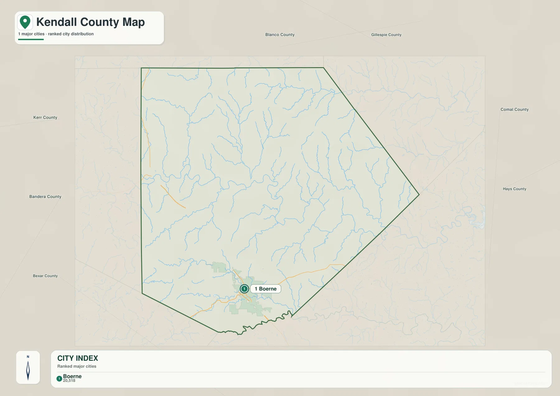
This distinction matters when choosing which map to use. If the task is to see roads, smaller place names, and the county boundary together, the general map provides more detail. If the goal is to show where the main city sits within Kendall County, the city view removes much of that detail and makes Boerne the immediate visual focus.
From the Blanco River to the Guadalupe: A Dense Network of Hill Country Streams
The terrain-and-water map contains some of the most county-specific information in the package. The Guadalupe River runs in a conspicuous meandering line through the central part of the county. Farther north, the Blanco River and East Fork Blanco River are labeled, while the Little Blanco River appears on the eastern side. Together, these rivers show that Kendall County is crossed by several drainage systems rather than being organized around a single watercourse.
Smaller streams add much more detail. Black Creek descends through the western side, Wasp Creek reaches toward the Guadalupe River, and Curry Creek is labeled east of the main river. Big Joshua Creek appears in the west, with Spring Creek and Cibolo Creek farther south. Boerne Lake and Lake Oz are also marked in the southwestern portion of the map. Because the shaded relief is visible beneath the blue hydrography, the viewer can see how many of these streams occupy narrow lower corridors between ridges.
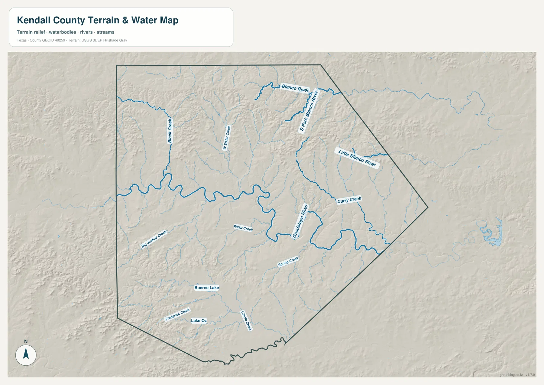
This is a reference map of terrain and named water features. It is not a flood-hazard map, a legal riparian-boundary map, or a navigation chart. A creek drawn on the image should therefore be used to understand location and landscape relationships, not to make property, construction, or flood-safety decisions.
Elevation from 308 to 634 Meters Across the Hill Country
The elevation map turns the county’s relief into an easy visual comparison. Its reported actual range is about 308 to 634 meters, with a mean elevation of 474 meters. Higher ground is concentrated across much of the north and west, where brown and tan ridges form a dense pattern. Lower green areas follow the central river corridor and many tributary valleys, producing a branching network that matches the drainage shapes seen on the water map.
The Guadalupe River corridor is especially clear. A broad lower band winds across the center, while short valleys climb into higher terrain on both sides. Northern Kendall County shows closely spaced ridges and drainage cuts, whereas the southeastern part of the county contains a larger share of lower terrain. This difference helps explain why a simple boundary-only map misses so much of the county’s character.
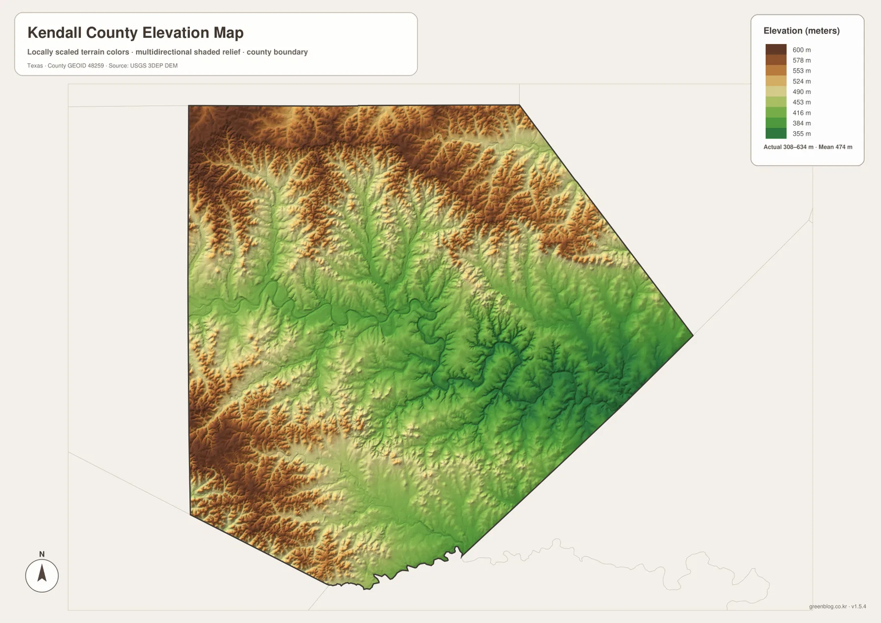
The elevation surface is based on a digital elevation model and is appropriate for regional comparison. It should not be treated as survey-grade elevation for an individual parcel, road project, building site, or engineering calculation. For those purposes, a current professional survey or project-specific elevation source is required.
What Changes When the Four Maps Are Read Together
Boerne provides a good example of why the four views complement one another. The county map shows the road junctions and nearby public facilities; the city map strips away much of that detail and highlights Boerne as the principal ranked city. The water map adds Cibolo Creek, Boerne Lake, and the larger Guadalupe system, while the elevation map shows the lower valleys and surrounding ridges. None of those views alone describes the place as clearly as the set does together.
Comfort offers a different comparison. On the general map it is tied closely to I-10 near the northwestern boundary. The terrain maps show a more rugged setting beyond that road corridor, with drainage lines cutting through higher western and northern ground. The contrast between these two places makes the county easier to understand without relying on generalized statements about all of the Texas Hill Country.
Kendall County Between San Antonio and the Higher Hill Country
Kendall County’s official overview describes the county as rolling to hilly terrain in the Edwards Plateau region and places Boerne about 30 miles northwest of San Antonio. That description matches the supplied maps closely. The southern side contains the county seat and the strongest road connection toward the metropolitan area, while the interior and northern side show a much more dissected landscape of ridges and stream valleys.
The surrounding counties provide useful orientation. Kerr and Bandera lie to the west, Gillespie and Blanco are on the northern side, Comal is to the east, and Bexar is south of Kendall County. Roads and rivers continue through this wider region, so the boundary is best understood as a jurisdictional line placed across a continuous Hill Country landscape. The map does not claim that all of those surrounding areas share the same settlement pattern or elevation; it simply makes the geographic connections visible.
Choosing the Best Map for Printing, Study or Reference
For a quick county orientation, the general map is the most direct choice because it combines the boundary, major roads, Boerne, Comfort, Fair Oaks Ranch, streams, and selected facilities. The city map works better when a presentation needs a cleaner visual centered on Boerne. The terrain-and-water map is the useful option for locating named rivers, creeks, and lakes, while the elevation map is better for comparing high ridges with lower valleys.
The downloadable files are especially useful when the screen-sized WebP images are not large enough. Each supplied map has a matching high-resolution JPG prepared for A3 output, and the four JPG files are grouped in one ZIP. They can be printed separately, placed side by side in a classroom, or used as reference images in a local geography project.
Frequently Asked Questions
Where is Boerne on the Kendall County map?
Boerne is near the southern edge of Kendall County, where I-10 and Route 87 pass through the city and State Highway 46 extends east. Its position makes it the easiest reference point for locating the southern part of the county and the route toward the San Antonio area.
Which rivers and creeks are labeled on the water map?
The Guadalupe River is the most prominent central waterway. The map also labels the Blanco River, East Fork Blanco River, Little Blanco River, Black Creek, Big Joshua Creek, Wasp Creek, Curry Creek, Spring Creek, Cibolo Creek, Boerne Lake, Lake Oz, and several smaller tributaries.
What elevation range does the Kendall County map show?
The supplied elevation map reports an actual range of about 308 to 634 meters and a mean of 474 meters. Higher ridges are common in the north and west, while lower terrain follows the Guadalupe River and other stream valleys.
Map File Information
The ZIP contains four high-resolution A3 JPG maps for Kendall County: the county map, city map, terrain-and-water map, and elevation map.
- File Type: ZIP containing 4 JPG files
Related Maps
- Bandera County Texas map
- Atascosa County Texas map
- Wilson County Texas map
- Travis County Texas map
- Real County Texas map
Sources and Further Reference
For county-specific background, the Kendall County official County Overview describes Boerne’s location and the county’s rolling-to-hilly Edwards Plateau setting. Administrative boundary data can be checked through the U.S. Census Bureau TIGER/Line Shapefiles.
Hydrography and elevation can be referenced through USGS National Hydrography and the USGS 3D Elevation Program. The USGS The National Map Viewer is also useful for comparing official geographic layers in one map interface.
Green Map creates custom-edited map images using open geographic data sources such as geoBoundaries, Natural Earth, OpenStreetMap, and government open data.
These maps are edited visual materials, not raw data files, and are provided for education, documents, presentations, and graphic reference.