You can download the Union County South Carolina Map files on this page as high-resolution A3 JPGs in one ZIP archive, with WebP previews available for quick browser viewing. The maps show how the county is organized around Union, with Jonesville to the northwest, Lockhart to the east, and Carlisle to the southeast. The general map adds numbered roads and nearby places, the city-connections map gives straight-line distances from Union, and the terrain-and-water map brings the Tyger River, Enoree River, Fairforest Creek, and smaller waterways into focus.
Union County is easier to read when the maps are used for different questions rather than treated as interchangeable copies. The road map is best for route numbers and settlement placement. The city view is cleaner when the only question is how Union, Jonesville, Lockhart, and Carlisle relate to one another. The terrain-and-water view then explains why so many small streams cross the county and how they connect with the larger river corridors in the south.
Table of Contents
Union anchors roads that spread toward Jonesville, Lockhart, and Carlisle
Union is the strongest visual center on the general county map. Several roads converge around the city before splitting in different directions. To the northwest, Route 18 leads toward Jonesville, where Routes 9 and 114 are also labeled. East of Union, Routes 105 and 49 provide the clearest numbered references on the way toward Lockhart. This separation is useful because Jonesville and Lockhart are not simply stops on one straight corridor; they sit on different sides of the county.
The southern half has its own pattern. A major road leaving Union toward the south reaches the 176 corridor, and farther down the map Routes 72 and 121 cross the lower part of the county. Carlisle sits in the southeast near Route 215. Reading those roads from Union outward creates a simple mental picture: Jonesville northwest, Lockhart east, and Carlisle southeast, with the central road network tying the directions together.
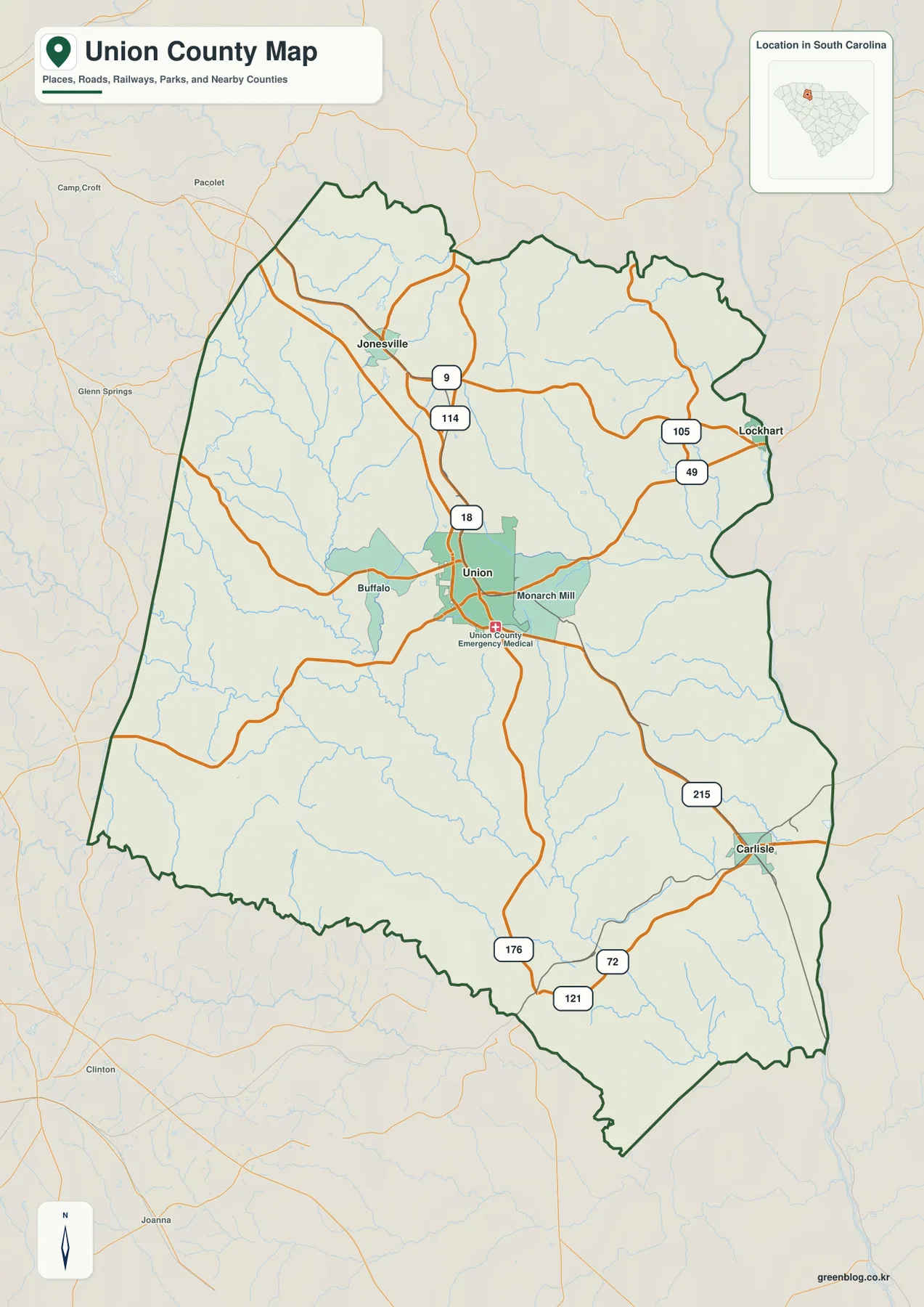
Buffalo and Monarch Mill appear close to Union and help add local detail around the county’s center. Jonesville is clearly separated to the northwest, while Lockhart is close to the eastern edge. Carlisle is farther south and east than either of them. The general map therefore works well not only for road lookup but also for understanding how the named communities occupy different parts of the county.
The city map compares 8, 11, and 13 miles from the Union hub
The city-connections map uses Union as its hub and lists three comparison distances: Jonesville at about 8 miles, Lockhart at about 11 miles, and Carlisle at about 13 miles. These are straight-line distances, not driving mileage. A road trip can be longer because actual routes bend, cross streams, and do not always follow the direct line between the labeled places.
Direction matters as much as the mileage. Jonesville lies northwest of Union, Lockhart is east, and Carlisle is southeast. The outside labels also frame the county within its neighbors. Spartanburg and Laurens counties appear to the west, Cherokee County to the north, Chester and York to the east and northeast, Fairfield to the southeast, and Newberry to the southwest. Those labels are useful for county orientation without requiring the reader to infer road access across every boundary.
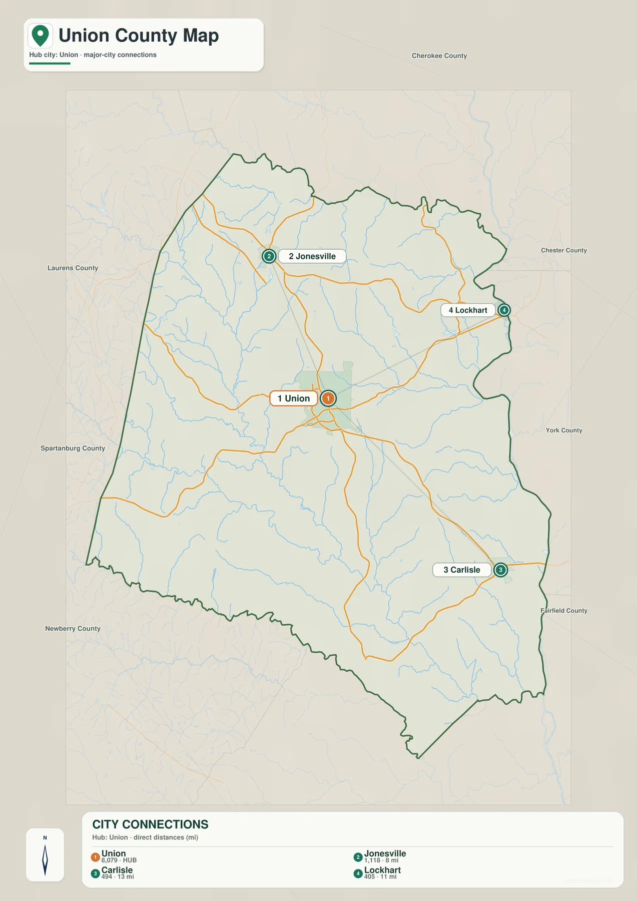
The numbered city markers are best treated as map-index labels. Union is marked 1, Jonesville 2, Carlisle 3, and Lockhart 4. The map is useful because it removes much of the road detail and makes the relative placement easy to see. Once a destination is located, the general county map can be used to add the actual road network.
Fairforest Creek leads into the stronger Tyger River corridor in the south
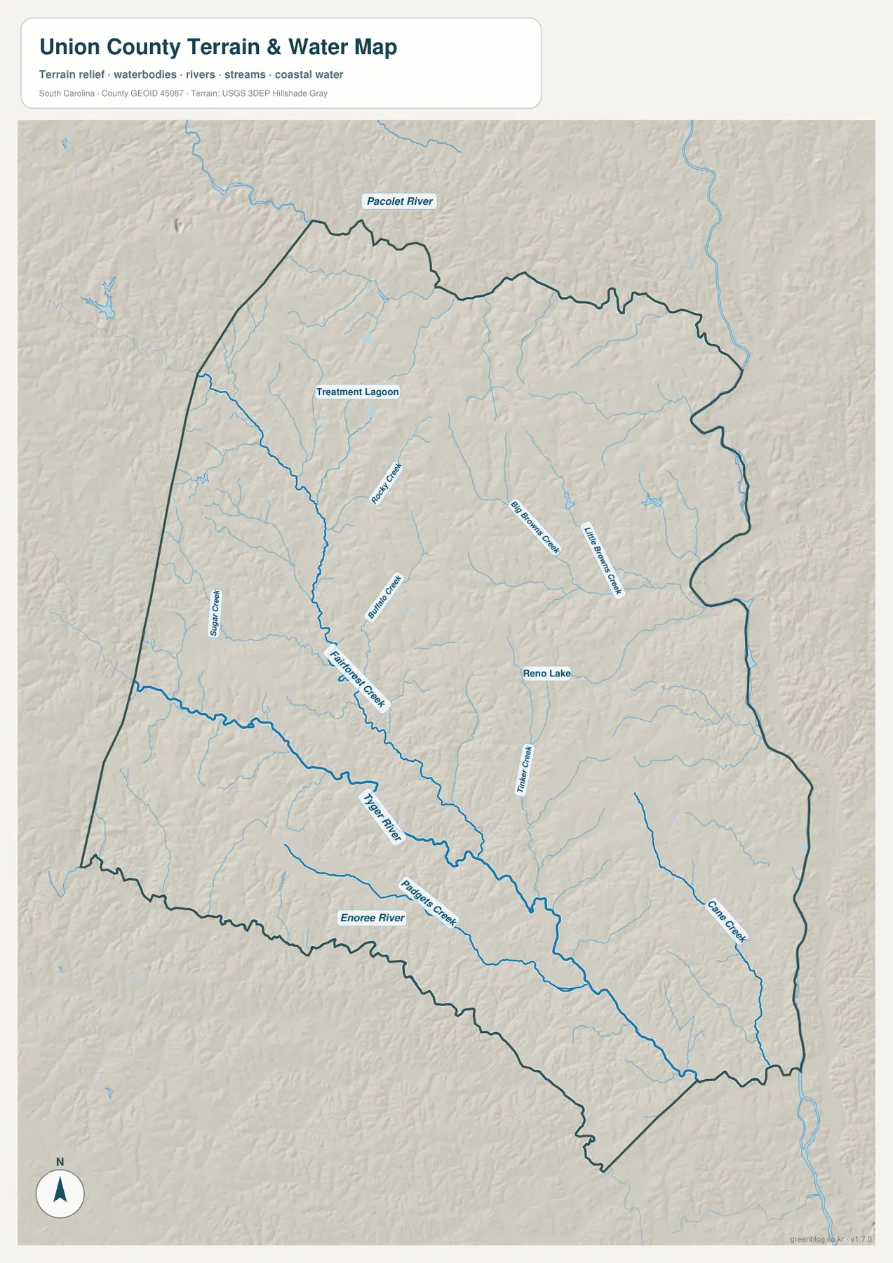
The terrain-and-water map reveals a denser drainage network than the road map suggests. Fairforest Creek is one of the clearest central waterways, running from the northwestern and central area toward the southern river system. Rocky Creek and Buffalo Creek are labeled nearby, showing how smaller streams feed into the broader drainage. The result is a county crossed by many branching channels rather than one single dominant river through the center.
In the southern half, the Tyger River becomes a major reference line. The Enoree River is labeled along the southwest side, with Padgetts Creek between the larger river corridors. Cane Creek occupies the southeastern section as a separate labeled stream. This water map is intended for geographic reference, not flood-risk, navigation, or water-depth decisions. Those tasks require current specialized data.
Big Brown Creek, Little Brown Creek, and Reno Lake define the eastern half
The eastern half of the water map has a different set of local references. Big Brown Creek and Little Brown Creek are labeled close to one another, while Tucker Creek appears farther south. Reno Lake sits in the east-central part of the county and gives the area a compact named waterbody that is easy to spot. North of the county boundary, the Pacolet River label provides additional regional context for the upper drainage.
Other smaller features fill gaps between the better-known rivers. Sugar Creek appears toward the west, and a Treatment Lagoon is labeled in the northwestern interior. Together with Buffalo Creek, Rocky Creek, and the Brown Creek pair, these names make the water map useful for much finer location checks than a map showing only the Tyger and Enoree rivers.
Rolling relief follows the creek valleys rather than a mountain ridge
The shaded terrain shows repeated low ridges and valleys across the county. The surface is not flat, but it does not display the steep mountain forms seen farther northwest in South Carolina. Fairforest Creek and its tributaries occupy lower paths through that rolling surface, while the southern river valleys form longer, more continuous low corridors.
The Tyger and Enoree river areas are especially useful for seeing how the relief and drainage fit together. Cane Creek also creates a clear linear low area in the southeast. Exact elevations cannot be read from the hillshade, so a dedicated elevation dataset is needed for spot heights or engineering work. Here the shading is most useful for comparing the relative shape of the land around the labeled waterways.
Choose the city view for placement, the road map for routes, and the water map for drainage
For a quick question such as “Where is Jonesville compared with Union?”, the city-connections map is the easiest starting point because it gives both direction and a straight-line distance. If the next question is how the places are connected, the general map adds Route 18 and the 9-114 area around Jonesville. The same workflow works for Lockhart and Carlisle using the eastern and southeastern road labels.
The terrain-and-water map is the better choice when the question involves creeks or rivers. It makes the relationship among Fairforest Creek, the Tyger River, the Enoree River, the Brown Creek pair, and Reno Lake much clearer than the road map can. The WebP previews on the page are optimized for screen viewing; the ZIP below contains the matching high-resolution A3 JPG originals for printing and larger layouts.
These maps are general geographic references rather than live-traffic, legal-boundary, parcel, flood-risk, survey, or engineering products. Road conditions can change, legal boundaries require authoritative records, and the shaded terrain does not provide exact spot elevations. Use current official sources whenever a decision depends on those details.
Frequently Asked Questions
Are the 8, 11, and 13 mile values on the city map driving distances?
No. The map shows straight-line distances from Union: about 8 miles to Jonesville, 11 miles to Lockhart, and 13 miles to Carlisle. Actual road mileage can be longer depending on the available route.
Which map is best for finding the Tyger River and Enoree River?
Use the terrain-and-water map. It shows the Tyger River through the southern part of the county and the Enoree River along the southwest side, along with Fairforest Creek, Buffalo Creek, the Brown Creek pair, Cane Creek, and other smaller waterways.
What files are included in the downloadable ZIP?
The ZIP contains three high-resolution A3 JPG files corresponding to the page previews: the general county map, the city-connections map, and the terrain-and-water map. The WebP versions in the article are lighter previews for browser use.
Map File Information
Download the Union County road map, city-connections map, and terrain-and-water map together as high-resolution A3 JPG files.
- Included Files: 3 JPG maps
Related Maps
Sources and Reference Data
- U.S. Census Bureau TIGER/Line Shapefiles: county boundaries, roads, and geographic reference data
- USGS National Hydrography: rivers, streams, lakes, and hydrographic reference data
- USGS 3D Elevation Program: terrain and elevation reference data
- South Carolina Association of Counties: county administrative reference information
Green Map creates custom-edited map images using open geographic data sources such as geoBoundaries, Natural Earth, OpenStreetMap, and government open data.
These maps are edited visual materials, not raw data files, and are provided for education, documents, presentations, and graphic reference.