Will County sits in northeastern Illinois where a dense suburban landscape in the north gives way to a much more open pattern of rivers, creeks, farmland, and smaller communities toward the south and east. Joliet is the most prominent city on the map, while Bolingbrook, Plainfield, Romeoville, Lockport, and New Lenox form a tight cluster around the northern and northwestern part of the county. Wilmington, Elwood, and Channahon lie farther south and southwest, while Crete and University Park occupy the broad eastern extension. This page explains those settlement and road patterns, the county’s major waterways, and an elevation range of about 122 to 255 meters. The same four maps are also available as original high-resolution JPG files in a downloadable ZIP archive.
The road network makes the northern concentration easy to see. I-55 runs through the western side near Plainfield and continues south toward Channahon and Wilmington. I-80 crosses the central urban belt through Joliet toward New Lenox and Frankfort. I-355 reaches the Bolingbrook and Homer Glen area, while I-57 provides a north-south reference in the eastern part of the county near University Park and Crete. South of the Joliet area, the settlement pattern opens quickly and blue creek lines become a larger part of the map, so the county feels very different from one end to the other.
Water and elevation add another layer to that contrast. The Des Plaines River follows a low corridor through the western side of the county, the Du Page River approaches from the northwest, and the Kankakee River occupies the southwestern lowlands. Farther east, Hickory Creek, Prairie Creek, Jackson Creek, Black Walnut Creek, and many smaller tributaries cut through higher ground. On the elevation map, those western river valleys appear in green while broad areas of the east and southeast rise into yellow and brown terrain. Looking at all four maps together makes it much easier to understand why the urban north, river-centered west, and higher eastern half look so different.
Table of Contents
Joliet and the road network that ties the northern cities together
Joliet is the most useful starting point on the county map because several major routes pass through or near it. I-80 crosses the county from west to east through the Joliet area and continues toward New Lenox and Frankfort. I-55 runs north-south on the western side, linking the Plainfield area with Channahon and Wilmington farther south. North of Joliet, Lockport and Romeoville sit close together along the Des Plaines corridor, and Bolingbrook lies farther north near I-355. Once those places are located, the main urban concentration of Will County becomes easy to recognize.
The northeastern county line has an irregular, stepped shape rather than a simple rectangular edge. Homer Glen occupies part of that northern projection, while New Lenox and Frankfort sit farther south and east along the central urban belt. The county then extends eastward again toward University Park and Crete. I-57 crosses that eastern section, giving the area a separate north-south reference from the I-55 corridor on the west. This shape matters when reading the map because two places that look equally far east may sit in different sections of the county boundary.
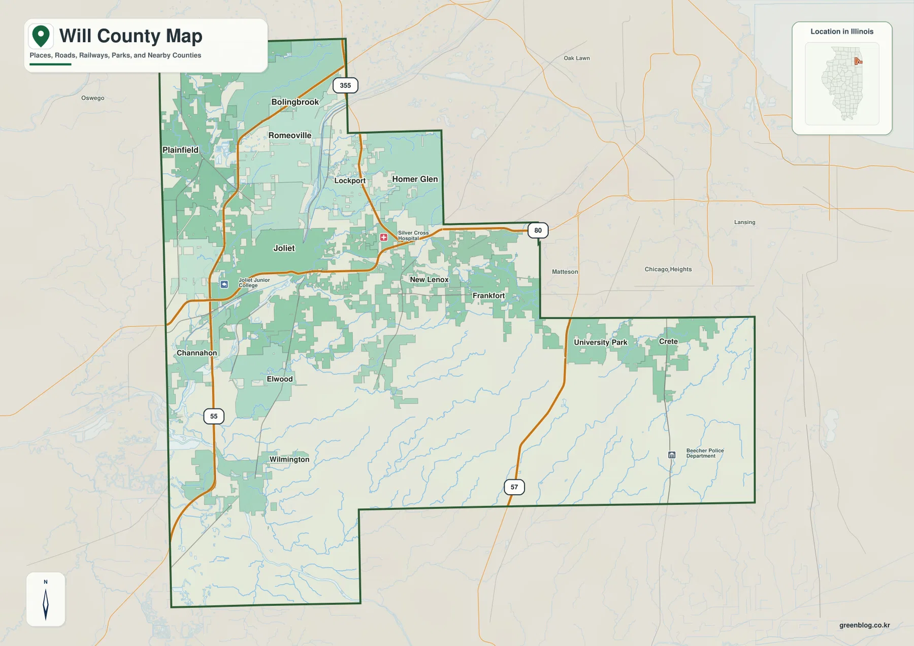
The southern and southwestern part of the county is noticeably less crowded. Channahon sits southwest of Joliet near I-55, Elwood lies to the east, and Wilmington is farther south. The gaps between communities are larger than they are around Joliet, Plainfield, and Romeoville, and watercourses occupy more of the visible landscape. Labels such as Joliet Junior College and Silver Cross Hospital provide useful orientation points on the detailed map, but the main value of this map is the relationship among settlements, roads, waterways, and the county boundary rather than any single facility.
This is an orientation map, not a live navigation product. It is useful for seeing that Bolingbrook is north of Joliet, that Plainfield lies to the northwest, and that Wilmington and Crete are much farther from the northern urban cluster. It does not show current traffic, construction, closures, or the fastest driving route. For trip planning, use up-to-date road information after using this map to establish the county-wide layout.
Six major cities reveal how strongly growth is concentrated in the northwest
The city map removes most road detail and highlights six major places. Its index ranks Joliet first, Bolingbrook second, Plainfield third, Romeoville fourth, New Lenox fifth, and Lockport sixth. The striking feature is not simply the order of the names but their geography: nearly all six sit in the northern or northwestern portion of Will County. Joliet, Plainfield, Romeoville, and Lockport are especially close on the county-wide view, with Bolingbrook farther north and New Lenox extending the group eastward.
The map’s city index prints population-style reference figures of 150,445 for Joliet, 74,096 for Bolingbrook, 46,708 for Plainfield, 41,152 for Romeoville, 28,006 for New Lenox, and 26,409 for Lockport. Those figures should be treated as values attached to this map package rather than as a substitute for the latest official population estimate. The more durable map-reading point is that the county’s largest listed communities are concentrated in one part of a county that extends far to the south and east.
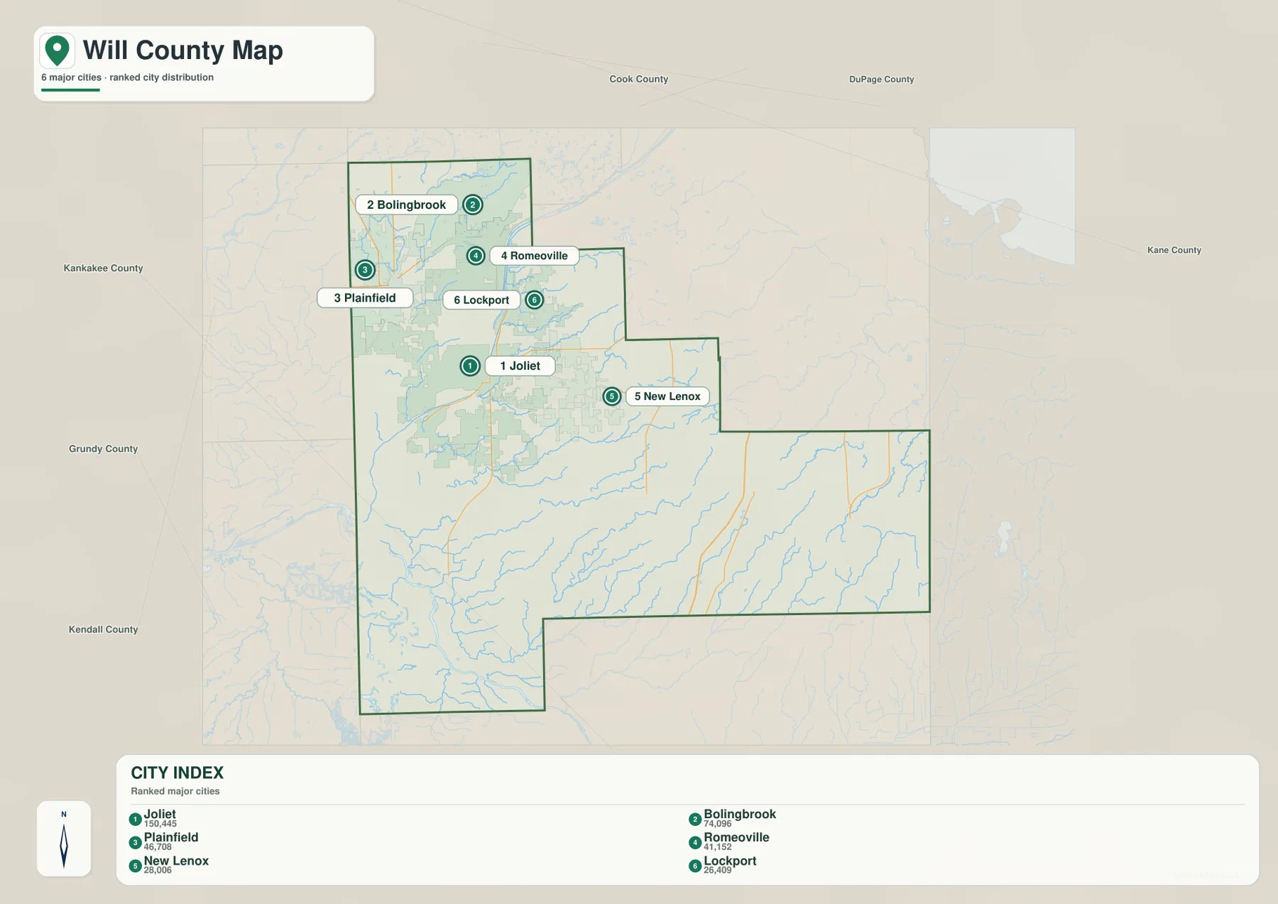
Several surrounding county names are printed outside the Will County outline to provide regional context, but the most dependable comparison on this map is the pattern inside the boundary itself. Joliet, Plainfield, Romeoville, Lockport, Bolingbrook, and New Lenox occupy a relatively compact northern and northwestern area, while the broad southern and eastern sections contain none of the six places highlighted in the city index. That contrast becomes even clearer when the city map is compared with the detailed map, where Wilmington, Elwood, Crete, and other smaller communities appear across the wider county.
No connector lines or straight-line distance labels are drawn between the cities on this version of the map. It should therefore be used to compare direction and relative position, not to calculate mileage or driving time. A practical approach is to learn the six-city pattern here first, then return to the detailed county map to see how I-55, I-80, I-355, and local roads connect those places.
The Des Plaines, Du Page, and Kankakee river lowlands
The waterways and terrain map shifts attention away from highways and toward the county’s drainage network. The Des Plaines River is the dominant feature on the western side, running through a long north-south corridor west of Lockport and Joliet. The Du Page River approaches from the northwest through the Plainfield and Channahon area, while the Kankakee River occupies the southwest near the county edge. Together, these rivers explain why the western side of Will County contains broad low corridors that look very different from the higher eastern landscape.
Several smaller water features are also easy to locate. Whalon Lake appears in the far north, while Lake Plainfield and Lake Renwick sit in the northwest. Long Run Creek crosses the north-central area, and Hickory Creek is a major labeled stream farther east. Jackson Creek and Prairie Creek run across the central and southern interior, Black Walnut Creek is labeled in the southeast, and Monee Reservoir provides a clear water landmark in the eastern half. These names make the map useful for understanding parts of Will County that can look relatively empty on a city-only map.
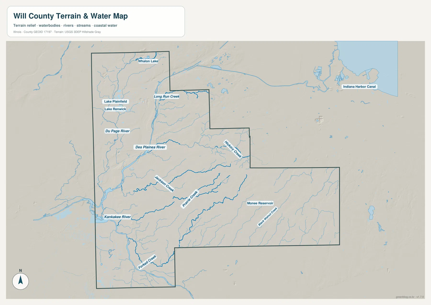
Comparing this map with the settlement map changes the way the county reads. The dense Romeoville-Lockport-Joliet area sits beside the Des Plaines corridor, while the land south of Joliet contains a wider spread of streams and larger gaps between towns. Around New Lenox and Frankfort, Hickory Creek becomes an important natural reference. Farther southeast, a branching network of smaller creeks crosses the more sparsely settled eastern extension. Waterways therefore provide a second set of reference lines that is often more useful than roads when the goal is to understand terrain rather than travel.
This map is a geographic water reference, not a flood-risk, parcel, navigation, depth, or water-quality product. A blue river or creek line does not indicate that surrounding land will flood, and the map should not be used to make engineering or property decisions. For those purposes, consult the appropriate official flood, hydrologic, or survey data. Here, the value is in seeing where major rivers, tributaries, lakes, and reservoirs sit in relation to the county’s communities and terrain.
A 122–255 m landscape: low western valleys and higher eastern ground
The elevation map gives Will County an actual mapped range of about 122 to 255 meters, with a mean near 202 meters. Green tones represent lower ground and yellow-to-brown tones represent higher ground. The lowest and most continuous green areas follow the Des Plaines River corridor on the west and the Kankakee River lowlands in the southwest. Around the area southwest of Joliet and toward Channahon and Wilmington, the low terrain broadens enough to dominate the map.
Higher ground becomes more prominent toward the east and southeast. East of New Lenox and Frankfort, broad brown and orange areas extend toward University Park and Crete. The southeastern part of the county is not a single smooth plateau; narrow green stream valleys cut through the higher terrain, creating a textured surface of ridges and drainage lines. Homer Glen and parts of the northeastern section also sit on higher ground than the main Des Plaines valley.
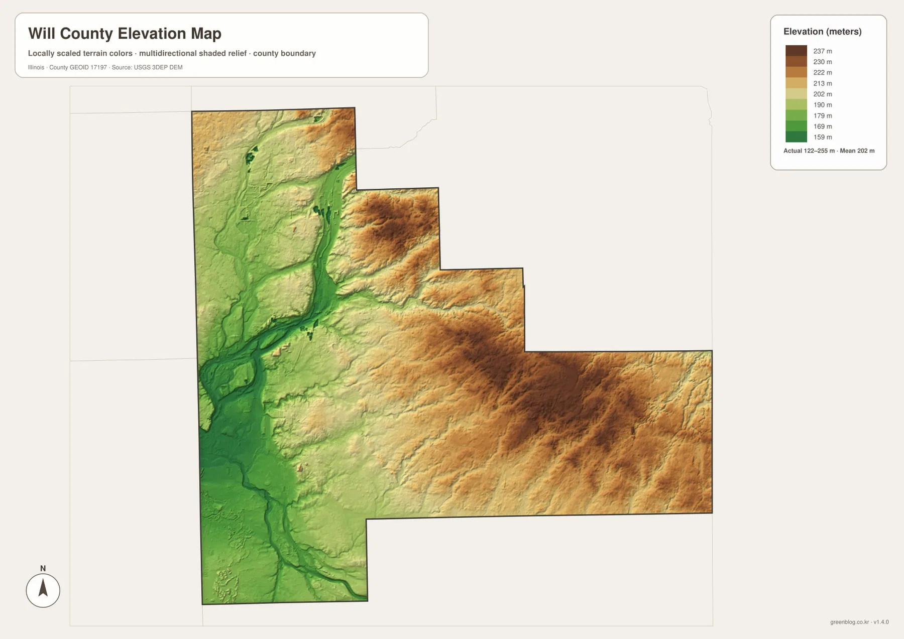
The connection between water and relief becomes clearest when the elevation and waterways maps are viewed together. The Des Plaines and Kankakee rivers follow the broadest low corridors, while the Du Page River and smaller tributaries occupy narrower depressions. In the east, Hickory Creek and Black Walnut Creek cut lower paths through otherwise higher ground. This is why the county cannot be described accurately as uniformly flat even though the total elevation range is modest compared with mountainous regions.
The elevation surface is generalized for county-scale comparison. It is not survey-grade or engineering-grade measurement, and it should not be used to determine the exact elevation of a house, road, farm field, construction site, or property corner. Detailed design, drainage, or surveying work requires more precise official elevation data or field measurements. For ordinary map reading, this version is best used to compare the low western river corridors with the higher eastern half of Will County.
Choosing the right map for roads, settlements, waterways, or relief
Use the detailed county map when you want to see Joliet, Bolingbrook, Plainfield, Romeoville, Lockport, New Lenox, and the major highway network together. Starting with I-55 and I-80 makes the urban pattern easy to organize, while I-355 and I-57 help explain the northern and eastern sections. If the amount of road detail is distracting, switch to the city map to learn the six major-city positions first and then return to the detailed version.
The waterways map is the better choice for the Des Plaines, Du Page, and Kankakee rivers, as well as Lake Renwick, Whalon Lake, Monee Reservoir, Hickory Creek, Prairie Creek, and the smaller tributaries. When the question is why those waterways occupy particular corridors, the elevation map adds the answer by showing the low western valleys and the higher eastern terrain. Used together, the water and elevation maps explain parts of the county that the road and city maps intentionally simplify.
The WebP images on this page are sized for quick viewing in a browser. The ZIP below contains the matching original high-resolution JPG files, each at 3638 × 2572 pixels. Those originals are easier to inspect at large scale or use for printing. Download all four once, then choose the county, city, waterways/terrain, or elevation version according to the information you need rather than trying to force every detail into one map.
Frequently Asked Questions
Which map is best for comparing Joliet with Bolingbrook, Plainfield, and Romeoville?
Use the detailed county map when roads matter. It shows Joliet near the center-west, Plainfield to the northwest, Romeoville and Lockport to the north, Bolingbrook farther north, and New Lenox to the east, along with I-55, I-80, I-355, and I-57. If you only want the relative positions of the six major cities, the simplified city map is faster to read. Neither map is intended to replace live navigation for current driving time or traffic conditions.
Why do the Des Plaines and Kankakee river areas appear lower on the elevation map?
Both rivers occupy broad low corridors, so their surroundings appear in the greener, lower-elevation colors. The difference is especially clear southwest of Joliet toward Channahon and Wilmington. Viewing the waterways and elevation maps together shows how the major rivers follow the lowest terrain. This does not mean every low area is a flood zone; flood risk requires a separate official flood map.
Does the 122–255 m range give the exact elevation of a property?
No. The approximately 122–255 m range describes the elevation values represented across the county-scale map. It is useful for comparing the low river valleys with higher eastern ground, but it is not precise enough for construction, drainage design, boundary surveying, or the exact elevation of an individual parcel. Those tasks require detailed USGS data, local engineering information, or field surveying.
Map File Information
This ZIP contains the original high-resolution JPG versions of the Will County boundary/settlement map, city distribution map, waterways/terrain map, and elevation map. Preview the maps on the page, then use the originals when you need more detail or a larger print.
- Printable Size: 3638 × 2572 px each
Related Maps
Sources and References
- Will County official website — county government and local reference information
- Forest Preserve District of Will County — preserve and natural-area information for places including Lake Renwick, Whalon Lake, Hickory Creek, and Monee Reservoir
- U.S. Census Bureau TIGER/Line Shapefiles — county boundary, roads, and place reference data
- USGS National Hydrography — rivers, streams, and water features
- USGS 3D Elevation Program — elevation data
Green Map creates custom-edited map images using open geographic data sources such as geoBoundaries, Natural Earth, OpenStreetMap, and government open data.
These maps are edited visual materials, not raw data files, and are provided for education, documents, presentations, and graphic reference.