This Swisher County Map set is organized around Tulia, the north-south I-27 and U.S. 87 corridor, the city sequence from Happy to Kress, and a set of Tule Draw valleys that deepen toward the eastern side of the county. Download the high-resolution A3 JPG map ZIP from the box below when you need printable or editable files; it contains separate county-reference, city-connections, terrain-and-water, and elevation maps.
Swisher County looks exceptionally orderly on the road map because Tulia sits near the middle and Happy and Kress line up along the same broad north-south corridor. The terrain maps tell a more complicated story. Happy Draw, North Tule Draw, Middle Tule Draw, and South Tule Draw cross the plateau toward Tule Creek, and the elevation surface drops markedly from the higher west toward the eastern canyon country. Numerous small round depressions are also visible across the otherwise broad, gently rolling surface.
Table of Contents
Tulia anchors the Happy-to-Kress highway corridor
Tulia is the easiest point to locate on the county reference map. Route shields 27 and 87 form the strongest north-south reference through the county, with Happy near the northern boundary and Kress in the south. That three-town sequence immediately gives the map a clear orientation and makes it easy to compare the northern and southern halves of Swisher County.
A network of numbered local roads spreads outward from Tulia. Labels 9, 13, 17, 19, and 146 are visible across the central area. Farther south, 928 and 145 provide useful references near Kress, while 86 crosses the eastern side and 20, 22, and 26 appear in the southeast. Route labels 194 and 614 mark the western edge. The local network is detailed, but it remains easy to read once the Tulia-centered north-south corridor is established first.
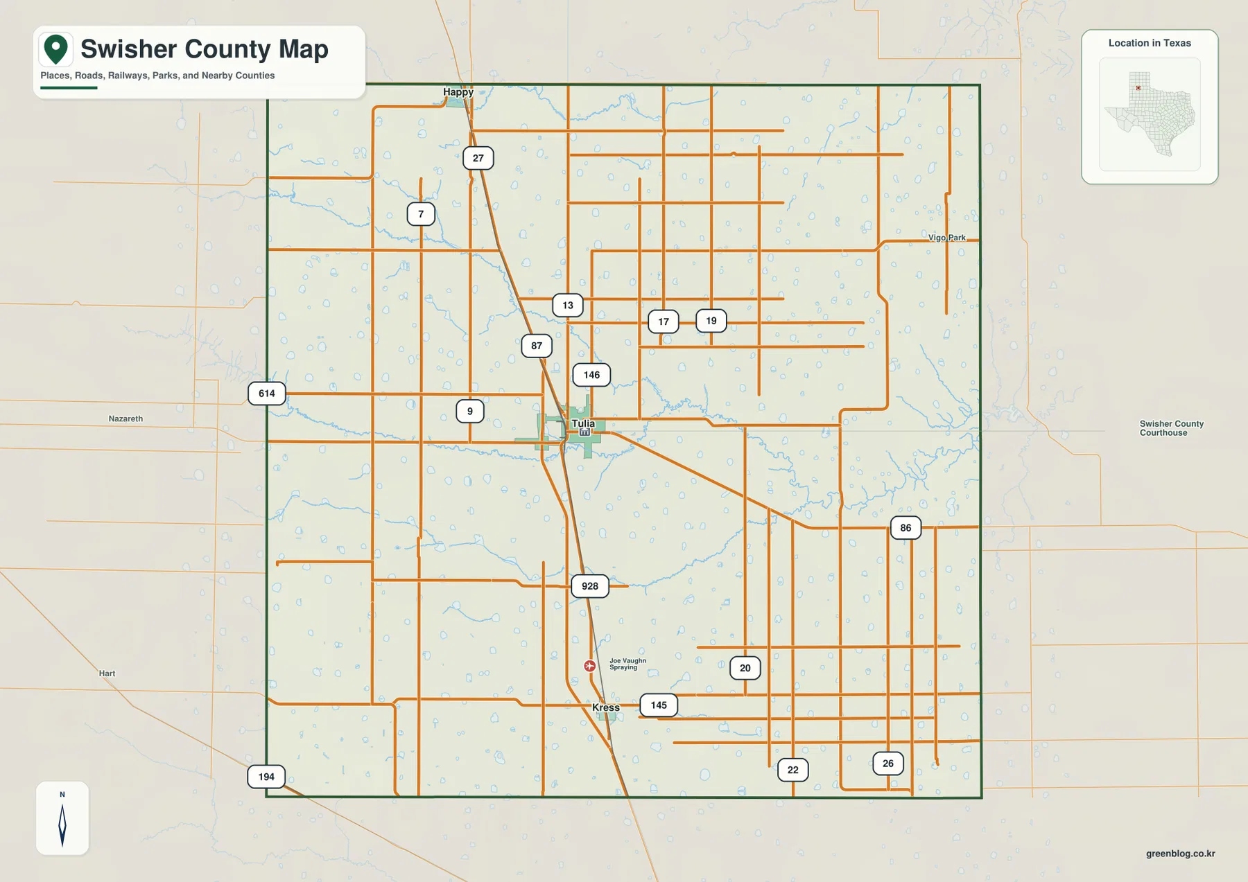
The drainage layer is already visible beneath the roads. Small blue basins and thin channels appear throughout the interior, but they become more pronounced east of Tulia where the main Tule drainage cuts more deeply into the plateau. The contrast between straight farm-road geometry and winding natural channels is one of the most useful details on the reference map.
Happy is about 15 miles from Tulia and Kress about 12 miles
The city-connections map uses Tulia as the hub and prints direct distances to the other two ranked towns. Happy is shown about 15 miles north of Tulia, while Kress is about 12 miles to the south. These are straight-line distances between mapped points, not driving mileages, so a road trip will generally be longer depending on the exact route and starting point.
The distance labels make the town sequence more informative than a simple north-south list. Tulia is not exactly halfway between the two outer places: Kress is slightly closer by the map’s direct measurement. For classroom material or a quick county overview, this simplified view makes the spacing of the three communities much clearer than the full reference map.
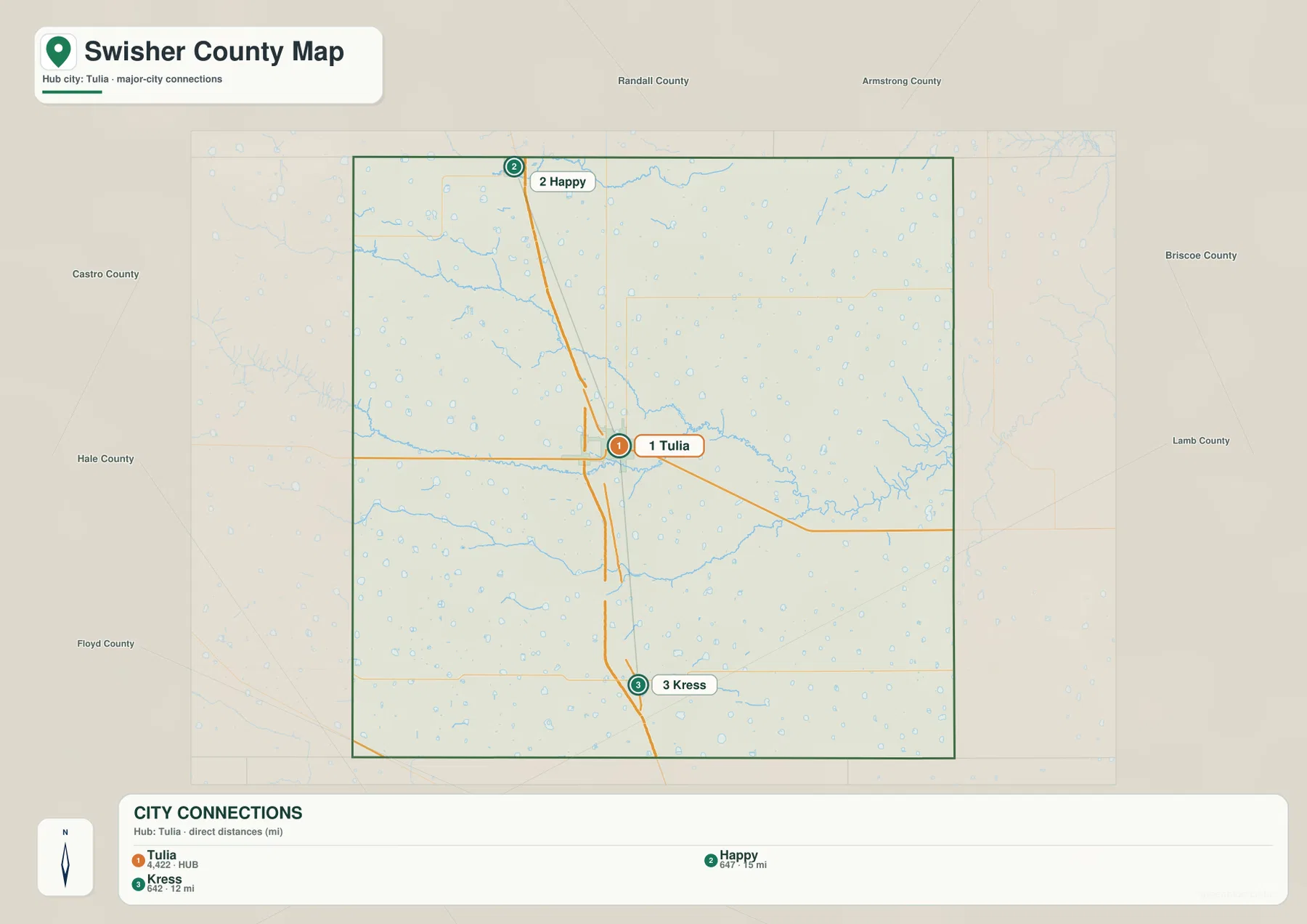
The CITY CONNECTIONS panel prints map values of 4,422 for Tulia, 647 for Happy, and 642 for Kress. Those figures explain the ranking used in the supplied graphic and should be treated as map values rather than guaranteed current population estimates. Anyone needing the latest demographic totals should use an official statistical source; for this map, the important point is Tulia’s hub role and the two outer towns’ relative positions.
The Tule Draws converge toward a deeper eastern drainage
The terrain-and-water map reveals a set of long drainage corridors that are easy to miss on the road layer. Happy Draw appears in the north, North Tule Draw follows farther south, Middle Tule Draw crosses the central interior, and South Tule Draw occupies the lower half of the county. They do not form a single straight channel, but all trend toward lower terrain on the eastern side.
Near the east-central boundary, the drainage becomes more strongly incised and Tule Creek is labeled along the deeper channel. Cope Creek appears outside the eastern edge as another nearby water reference. The existing article material identifies Tule Canyon as the major relief break on the eastern side, and the supplied water and elevation maps support that description by showing the plateau surface cut more sharply where the Tule drainage leaves the county.
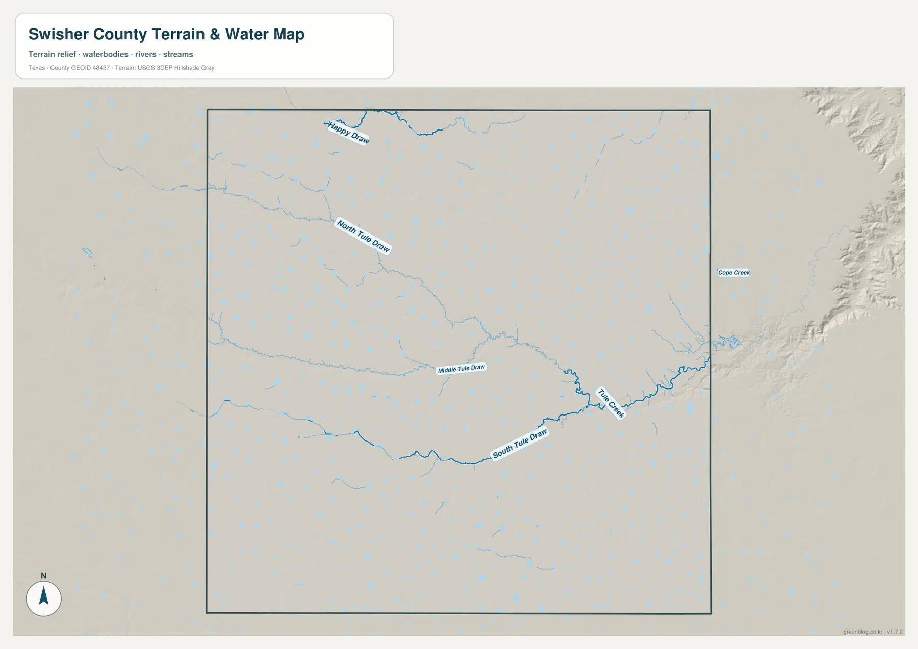
This map is intended to show geographic water and terrain relationships. It is not a flood-risk map, parcel-boundary product, navigation chart, or substitute for local water-management information. Its most useful role here is to show where the draws cross the plateau and why the eastern side has more pronounced relief.
Elevation falls from the high western plateau toward Tule Creek
The elevation map reports an actual range of about 934 to 1,140 meters and a mean elevation of 1,060 meters. Brown and tan high ground dominates the west and northwest, while colors gradually shift through yellow-green toward the east. The deepest green terrain occurs around the eastern Tule drainage, giving the county a clear west-to-east elevation contrast.
Another distinctive feature is the large number of rounded shallow depressions scattered across the plateau. Many are visible even on the higher western and central surface, and some correspond to small blue basins on the reference map. These circular lows are quite different from the long, branching Tule Draw valleys. Seeing both forms on one elevation surface helps explain why a landscape that appears broadly flat can still contain many local changes in relief.
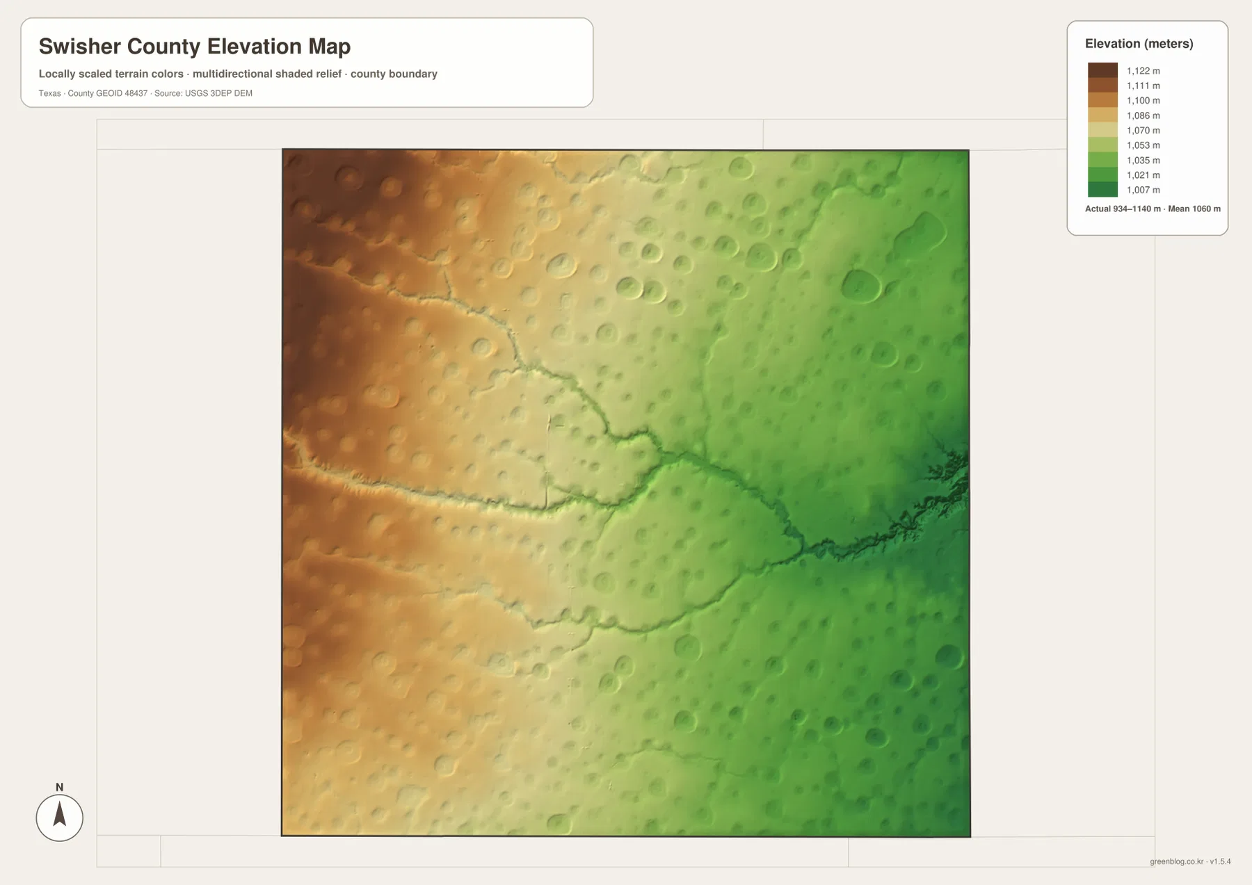
This countywide elevation surface is designed for broad terrain comparison rather than parcel surveying or engineering design. It is useful for seeing which side of the county is higher, how the Tule Draws occupy lower corridors, and how small rounded depressions differ from the larger eastern valley system. Exact site elevation should be checked with detailed source data or a local survey.
Choose the map by whether towns, drainage, or relief matters most
Use the county reference map when Tulia, Happy, Kress, I-27, U.S. 87, local road numbers, and the county boundary need to appear together. The city-connections map is better for comparing the direct spacing of the three towns. The terrain-and-water view is the best place to trace Happy Draw and the Tule Draw system, while the elevation map makes the high western plateau and lower eastern corridor easiest to compare.
The downloadable ZIP contains four separate high-resolution A3 JPG files for Swisher County: county reference, city connections, terrain and water, and elevation. You can inspect the lighter WebP versions in the article first and then use the larger JPG files for printing, classroom material, presentations, or an editable local-reference document.
Frequently Asked Questions
How far are Happy and Kress from Tulia on the city map?
The supplied city-connections map shows Happy about 15 miles from Tulia and Kress about 12 miles away by straight-line distance. Driving mileage will vary with the road route and exact starting point.
Which way does the Tule drainage run across Swisher County?
Happy Draw and the North, Middle, and South Tule Draws generally extend toward lower ground on the eastern side, where Tule Creek is labeled along the deeper drainage corridor.
What elevation range is shown for Swisher County?
The supplied elevation map states an actual range of about 934 to 1,140 meters and a mean elevation of 1,060 meters. The west is generally higher, while the eastern Tule drainage is lower.
Map File Information
The ZIP contains the four Swisher County maps in high-resolution A3 JPG format.
- Included Versions: County reference, city connections, terrain and water, elevation
- Included Files: 4 A3 JPG maps
Related Maps
Sources and data references
Roads, place locations, and the Swisher County boundary can be cross-checked with the U.S. Census Bureau TIGER/Line Shapefiles. Happy Draw, the Tule Draws, and Tule Creek can be checked against USGS National Hydrography, while terrain height data are available through the USGS 3D Elevation Program. The direct town distances, road labels, water names, and 934–1,140 meter elevation range described above are based on the Swisher County maps and existing article material supplied in this package.
Green Map creates custom-edited map images using open geographic data sources such as geoBoundaries, Natural Earth, OpenStreetMap, and government open data.
These maps are edited visual materials, not raw data files, and are provided for education, documents, presentations, and graphic reference.