The Bleckley County Map on this page provides four complementary views of a small central Georgia county: the road and boundary pattern around Cochran, the ranked location of Cochran and Allentown, the network of named creeks and ponds, and a terrain view ranging from about 64 to 144 meters in elevation. The WEBP previews are designed for quick reading on the page, and you can download one ZIP containing four high-resolution A3 JPG maps when you need larger files for printing, lessons, reports, or presentations.
Cochran is the best starting point for reading Bleckley County. It sits a little southwest of the county’s center where several numbered routes converge, while Allentown occupies the pointed northeastern end. Between and around those settlements, the water map reveals a dense set of creeks, including Rocky Creek, Gum Swamp Creek, and South Shellstone Creek. The elevation view then shows that the county is not uniformly flat: higher ridges and rolling ground alternate with lower stream valleys. Reading the maps in that order makes the county’s road, settlement, water, and terrain relationships much easier to follow.
Table of Contents
Cochran, the County Boundary, and the Main Road Pattern
The general county map draws Bleckley’s irregular boundary in dark green and overlays selected highways, place labels, streams, and surrounding context. Cochran is the most prominent settlement inside the county, located slightly southwest of center. Allentown is labeled at the narrow northeastern tip, and Empire appears in the southeast. Those three labels immediately show that settlement is dispersed across a long, angular county rather than concentrated along one straight corridor.
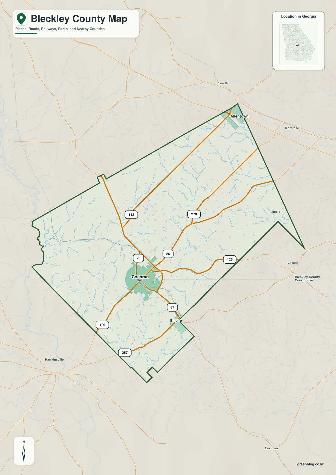
Route shields help organize the map. US 23 and SR 87 run through Cochran and provide a strong north-south reference, while SR 26 leaves the Cochran area toward the east. The map also labels SR 112, 126, 129, 257, and 278. Rather than treating every road as equal, it is useful to locate Cochran first and then trace these numbered routes outward. That approach shows how the county seat connects to rural parts of Bleckley and to roads continuing toward surrounding counties.
| State | Georgia |
|---|---|
| County | Bleckley County |
| County seat | Cochran |
| Created | 1912 from Pulaski County |
| 2020 population | 12,583 |
| Land area | About 215.87 square miles |
| Ranked city labels | Cochran and Allentown |
| Mapped elevation | About 64–144 m; mean 107 m |
| Named water references | Rocky Creek, Gum Swamp Creek, South Shellstone Creek, Lake Linda, and others |
| Download | Four high-resolution A3 JPG maps in one ZIP |
The supplied county material lists Bleckley County as having been formed in 1912 from Pulaski County, with 12,583 residents in the 2020 Census and about 215.87 square miles of land. Those figures help explain the scale of the map: this is a compact county with one clear administrative center rather than a large metropolitan area containing many comparable cities. The map works well for county orientation and regional context, but it is not a parcel survey, legal boundary record, or turn-by-turn navigation product.
The previous county reference material places Houston County to the west, Pulaski County to the southwest, Twiggs and Wilkinson counties along the northern side, Laurens County to the east, and Dodge County to the southeast. The current map is most useful when those neighboring directions are treated as broad context rather than as a substitute for a detailed boundary database. Bleckley’s outline contains several bends and narrow extensions, so a quick glance at the shape alone can be misleading without the surrounding names and road directions.
Cochran and Allentown in the Ranked City View
The city map intentionally strips away much of the detail and emphasizes the county’s two ranked settlement labels. Cochran is marked as number 1 with a city-index value of 4,803, and Allentown is number 2 with a value of 341. Those are the values printed on the supplied map; this page does not assign them an unstated census year or statistical definition. What the graphic clearly establishes is the large difference in prominence between the county seat and the smaller northeastern settlement.
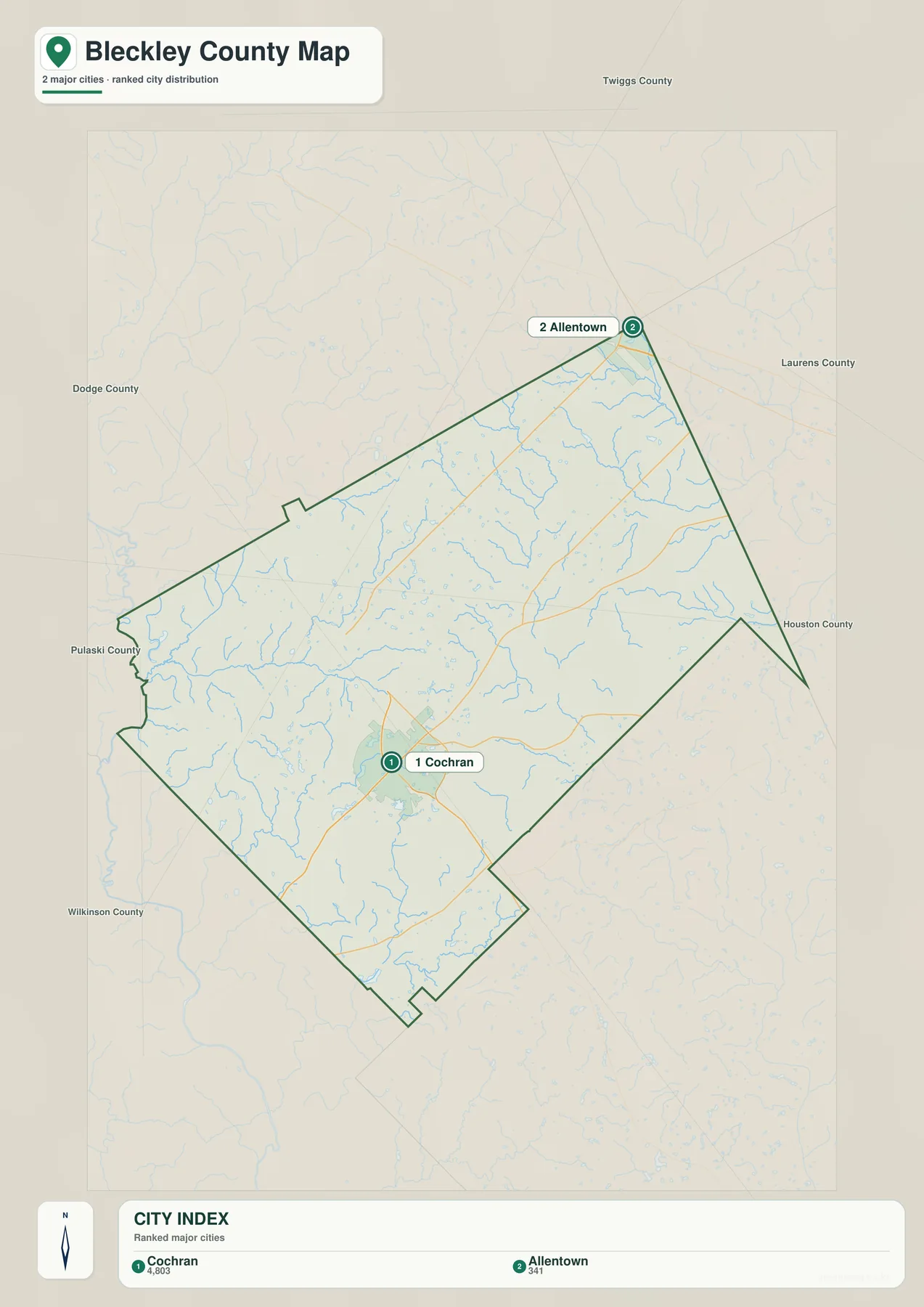
Cochran’s map position also matches the background information preserved in the original county article. It is the county seat and the location of the Cochran campus of Middle Georgia State University, so administrative and educational functions are concentrated in the same place where several important roads meet. That combination makes Cochran more than a convenient label: it is the practical anchor for understanding travel, services, and local orientation across Bleckley County.
Allentown sits near the northeastern point of the county, well separated from Cochran by a broad rural interior. The city map does not show a measured connector distance between the two places, so no road mileage or straight-line mileage should be inferred from the graphic. Its value is simpler: it lets a reader compare the central-southwestern location of Cochran with the northeastern location of Allentown without the distraction of the full road network.
Creeks, Branches, and Small Water Bodies Across Bleckley County
The terrain-and-water map shifts attention away from roads and toward the county’s internal drainage network. Rocky Creek and Crooked Creek are labeled in the northeast. Gum Swamp Creek runs through the central-northern part of the county, with Reedy Creek nearby, while Evergreen Creek and South Shellstone Creek are prominent farther west. Numerous thinner tributaries join these named channels, showing a much denser water pattern than the general road map can display clearly.
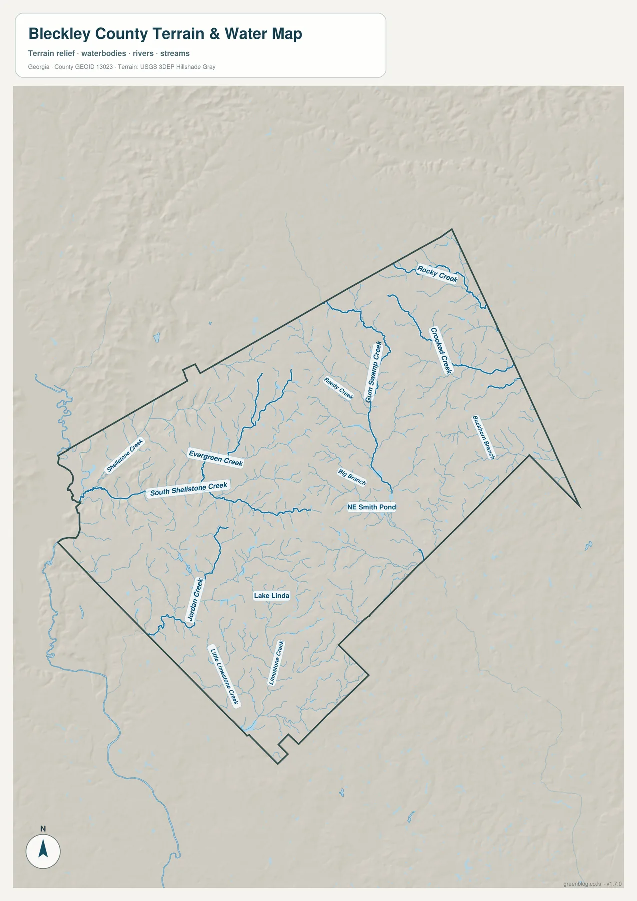
The southern half has a different set of labels. Jordan Creek appears in the southwest, while Little Limestone Creek and Limestone Creek run through the southern portion. Lake Linda is labeled near the south-central area, and NE Smith Pond appears closer to the middle of the county. Big Branch and Buckhorn Branch add more detail on the central and eastern sides. Together these names make the map useful for finding the relative position of local water features that would be easy to miss on a simpler county outline.
The original county material also discusses the Ocmulgee River and its floodplain along the western side of the broader local landscape. On this particular water preview, however, the emphasis is on the named internal creeks and ponds rather than on an Ocmulgee River label inside the county. That distinction matters. The map should be read as a county water-reference and terrain graphic, not as a claim that every major river, wetland, or hydrologic boundary has been labeled.
Blue lines on the map do not indicate flood zones, water depth, navigability, public access, or parcel boundaries. A creek may be important to local drainage without being suitable for boating or public recreation, and a nearby property cannot be classified as flood-prone merely because a mapped stream is close to it. Flood insurance, emergency planning, land transactions, and engineering decisions require current specialized data from the responsible agencies.
A 64–144 Meter Landscape of Ridges and Stream Valleys
The elevation map uses locally scaled terrain colors and shaded relief to make small changes in height visible. Its legend gives an actual mapped range of about 64 to 144 meters and a mean elevation of 107 meters. Brown and tan areas represent relatively higher ground, while green areas mark lower elevations. Higher rolling terrain is widespread in the northern and northeastern parts and across several central ridges, whereas lower green corridors appear along the western edge and through parts of the south.
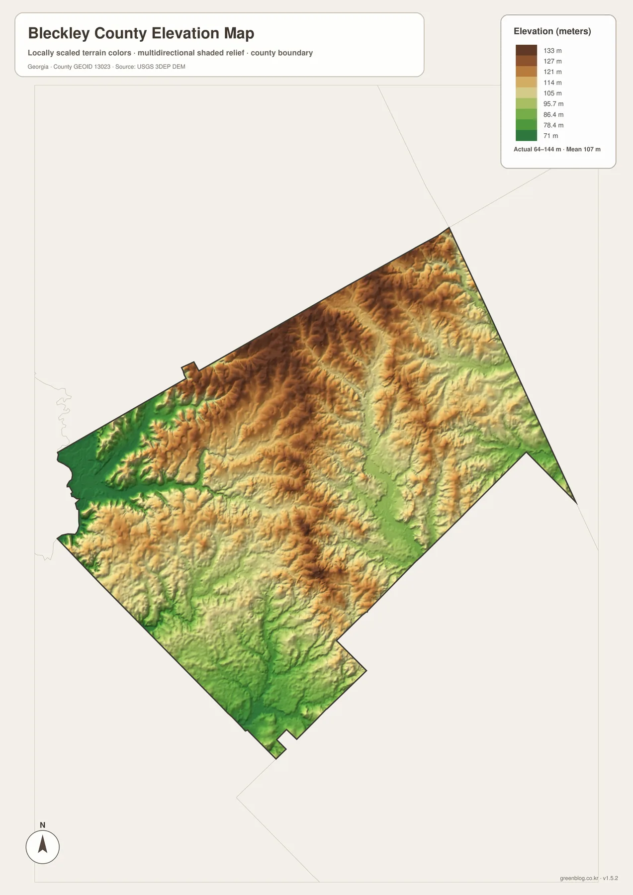
The shaded surface is especially useful when compared with the water map. Many creek corridors occupy lower strips between the ridges, so the branching drainage pattern makes more sense after the elevation view is added. The relief is not mountainous, but it is far from featureless. Small ridges, shallow valleys, and repeated changes in slope create a textured landscape across much of Bleckley County.
This is a county-scale elevation reference rather than a survey-grade model. The colors are designed to compare relative height across the whole county, not to provide a construction elevation for a house, road, culvert, or property corner. For classroom or regional-reference use, the map is valuable because it immediately shows where higher and lower terrain occurs. For engineering, drainage design, or legal work, a more precise and current elevation source is required.
Using the Maps With Bleckley County’s Local Background
Bleckley County was created in 1912, and the supplied background material connects its name to Logan Edwin Bleckley, a former chief justice of the Georgia Supreme Court. Cochran had developed earlier as a rail-oriented community and later became the county seat. The original article also notes the presence of the Cochran campus of Middle Georgia State University. These details help explain why a relatively small county has such a strong single center on the city map and why the road map is easiest to read outward from Cochran.
For a transportation or administrative project, start with the county map and city map. The county view shows numbered roads and the irregular boundary, while the ranked city view reduces the geography to Cochran and Allentown. For an environmental or physical-geography project, begin with the water and elevation maps instead. Locating Gum Swamp Creek, Rocky Creek, South Shellstone Creek, or Jordan Creek and then checking the same area on the elevation surface creates a direct connection between named water features and the valleys they occupy.
- Use the county map for the boundary, Cochran, Allentown, Empire, and numbered road orientation.
- Use the city map when the main question is the relative position and prominence of Cochran and Allentown.
- Use the water map for named creeks, branches, ponds, and the finer drainage network.
- Use the elevation map to compare rolling ridges with lower stream valleys across the 64–144 meter range.
What These Maps Show — and What They Do Not
These files are designed to make county-scale geography easy to understand. They are useful for identifying the overall shape of Bleckley County, the position of Cochran and Allentown, the direction of selected numbered roads, named streams, and broad elevation differences. They are not updated street-navigation maps, and the county boundary should not be used to decide ownership or the exact position of a parcel line. Places close to the county edge may require a more detailed official boundary source when jurisdiction matters.
The same caution applies to the physical maps. The water view does not classify flood risk or public access, and the elevation view does not provide survey measurements for a specific site. Their strength is comparative: a reader can see where the main named creeks run, where lower valleys appear, and how higher ground is distributed across the county. That is enough for many educational and reference uses, while high-stakes decisions should move to the latest specialized agency data.
Frequently Asked Questions
Where are Cochran and Allentown on the Bleckley County maps?
Cochran appears slightly southwest of the county’s center and is the dominant settlement on both the road and city views. Allentown is near the pointed northeastern end. The city map makes this contrast especially clear by ranking Cochran first and Allentown second.
Can the water map be used to determine flood risk?
No. It is a reference map for the location of named creeks, branches, ponds, and smaller tributaries. It does not show flood probability, flood depth, insurance zones, parcel boundaries, or public access. Those questions require current hydrologic and flood-management data.
What does the 64–144 meter elevation range mean?
It is the actual range printed on the supplied county elevation map, which also reports a mean of 107 meters. The range is useful for comparing higher ridges with lower valleys across Bleckley County, but it is not a survey measurement for an individual property or construction site.
Map File Information
Bleckley County A3 map files
- Included Files: 4 high-resolution A3 JPG map files shown in this article
- File Type: JPG files in a ZIP archive
- Intended Use: Printing, education, presentations, and map-based projects
Related Maps
Sources and References
- U.S. Census Bureau QuickFacts — Bleckley County population and area context
- Georgia Department of Community Affairs joint comprehensive plan — county and Cochran planning context
- New Georgia Encyclopedia: Bleckley County — county formation and local history
- USGS National Hydrography — hydrography reference
- USGS 3D Elevation Program — elevation reference
Green Map creates custom-edited map images using open geographic data sources such as geoBoundaries, Natural Earth, OpenStreetMap, and government open data. These maps are edited visual materials, not raw data files, and are provided for education, documents, presentations, and graphic reference.