The Brantley County Map on this page is designed to make southeastern Georgia easier to understand at county scale. It shows the county boundary, the relationship between Nahunta and Hoboken, the main numbered roads, the Satilla and Little Satilla river systems, and a low Coastal Plain landscape that ranges from about 2 to 45 meters in the supplied elevation view. The four maps can be inspected as fast-loading WEBP previews, and visitors who need larger files for printing, lessons, presentations, or reference work can download one ZIP containing four high-resolution A3 JPG maps. Each view answers a different practical question without turning the page into a technical GIS report.
A useful way to begin is with Nahunta, slightly east of the county center. US 82 crosses the county through Hoboken and Nahunta, while US 301 provides a strong north–south reference at Nahunta. The broader county map also labels Hortense, Hickox, and Waynesville, so it gives more context than the ranked city view. The water map shifts attention away from roads and toward the Satilla River, Little Satilla River, Dead River, Mill Creek, Buffalo Creek, Big Creek, and many smaller tributaries. The elevation map then explains why those waterways occupy such a distinctive setting: Brantley County is generally low, with higher brown terrain concentrated mainly in the west and southwest and lower green areas extending through much of the north-central and eastern side.
Table of Contents
County Boundary, Nahunta, and the Main Road Network
The county reference map uses a dark outline to separate Brantley County from its neighbors and places roads, selected communities, waterways, and a Georgia location inset on the same page. Nahunta is the easiest point from which to orient the map because several routes converge there. US 82 forms the obvious east–west line through the county, and US 301 runs south from the Nahunta area. Route shields for 520, 23, 32, 110, 177, 15, and 121 also appear on the map. These labels are useful for understanding direction and connection, even though the image is not intended to replace a current navigation map or provide turn-by-turn travel information.
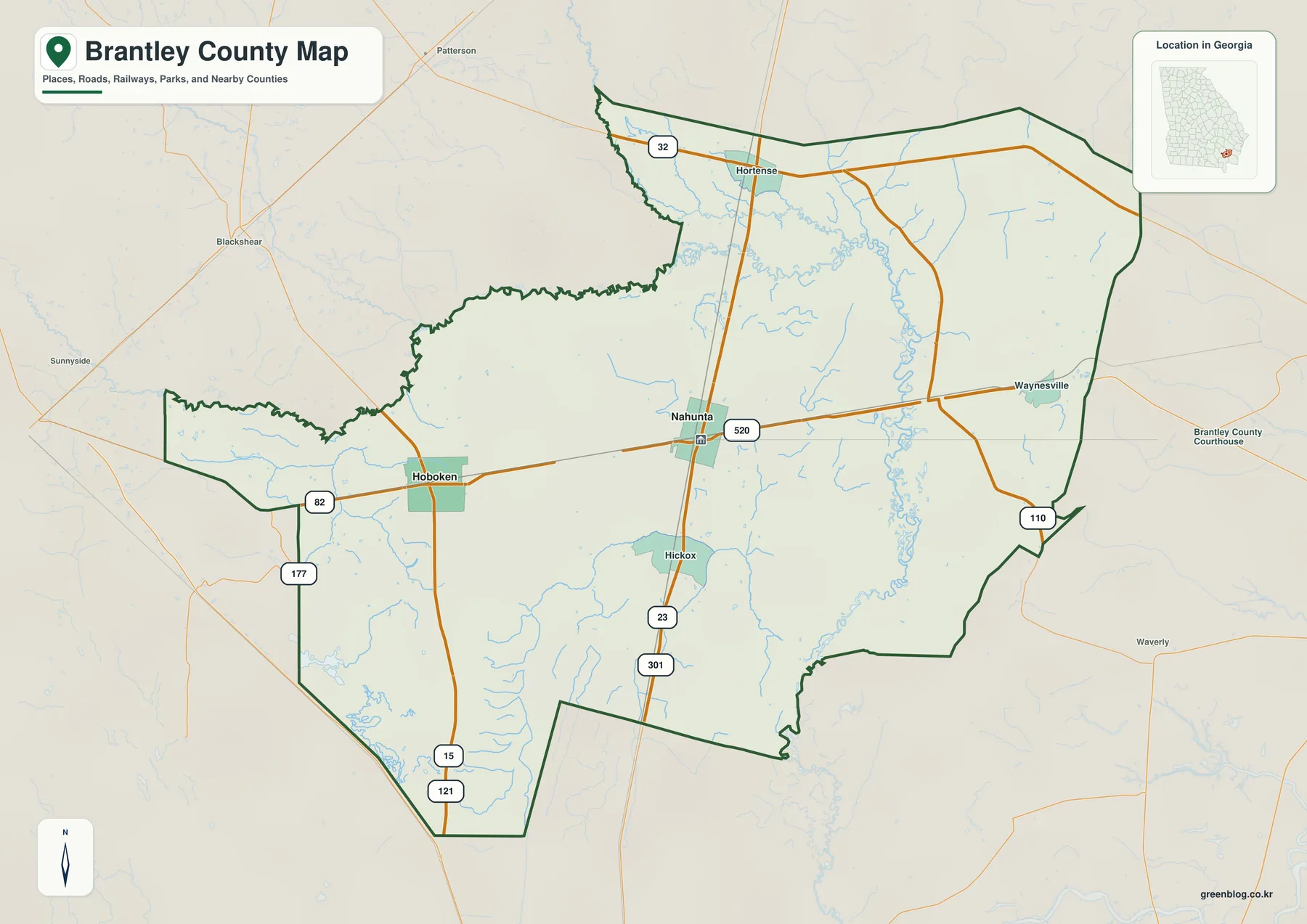
Hoboken lies west of Nahunta along US 82, making the two incorporated cities easy to compare on a single east–west corridor. Hortense appears north of Nahunta, Hickox is to the south, and Waynesville is labeled toward the eastern side. The current source article also identifies unincorporated communities such as Atkinson, Lulaton, Schlatterville, and Trudie. Their absence from this particular preview should not be read as evidence that the surrounding countryside is empty. The map is intentionally selective so that the county shape and the most useful orientation features remain readable.
The neighboring-county context is equally important. Brantley County is bordered by Wayne County to the northeast, Glynn County to the east, Camden County to the southeast, Charlton County to the southwest, Ware County to the west, and Pierce County to the northwest. On the reference map, nearby places outside the boundary help establish the county between the Brunswick and coastal side of southeastern Georgia and the Waycross side farther inland. That regional position is useful for travel planning and classroom context, but the dark county line should never be treated as a parcel boundary or a survey line for a specific property.
| State | Georgia |
|---|---|
| County seat | Nahunta |
| Incorporated cities | Nahunta and Hoboken |
| Created | August 14, 1920; described in the supplied background as Georgia’s 154th county |
| 2020 Census population | 18,021 |
| July 1, 2025 estimate | 18,936 |
| Land area | 443.24 square miles |
| 2020 population density | 40.7 people per square mile |
| Mapped elevation range | about 2–45 m; mean 22 m |
| Download | four high-resolution A3 JPG files in one ZIP |
The population, area, and formation values in the table come from the background material supplied with this rewrite package. The combination of 443.24 square miles of land and a 2020 density of 40.7 people per square mile helps explain the broad gaps between the main settlements. Brantley County is not mapped like a compact urban county with a dense street grid. Large rural areas, forests, wetlands, waterways, and small communities extend beyond the two incorporated cities, so the major roads and named rivers are often better orientation tools than the number of labels visible on the page.
Nahunta and Hoboken as the Two Main City Markers
The ranked city map deliberately removes much of the detail found on the county reference map. It highlights Nahunta and Hoboken as the two major city markers and places them against a simplified county outline with neighboring county names around the edge. The CITY INDEX prints a value of 1,386 for Nahunta and 1,016 for Hoboken. Because the preview does not identify the year or statistical definition attached to those numbers, they are best treated as values printed on this particular map rather than as a claim about the latest population count. The more dependable takeaway is the geographic pattern: Nahunta is near the central-eastern part of the county, while Hoboken is well to the west.
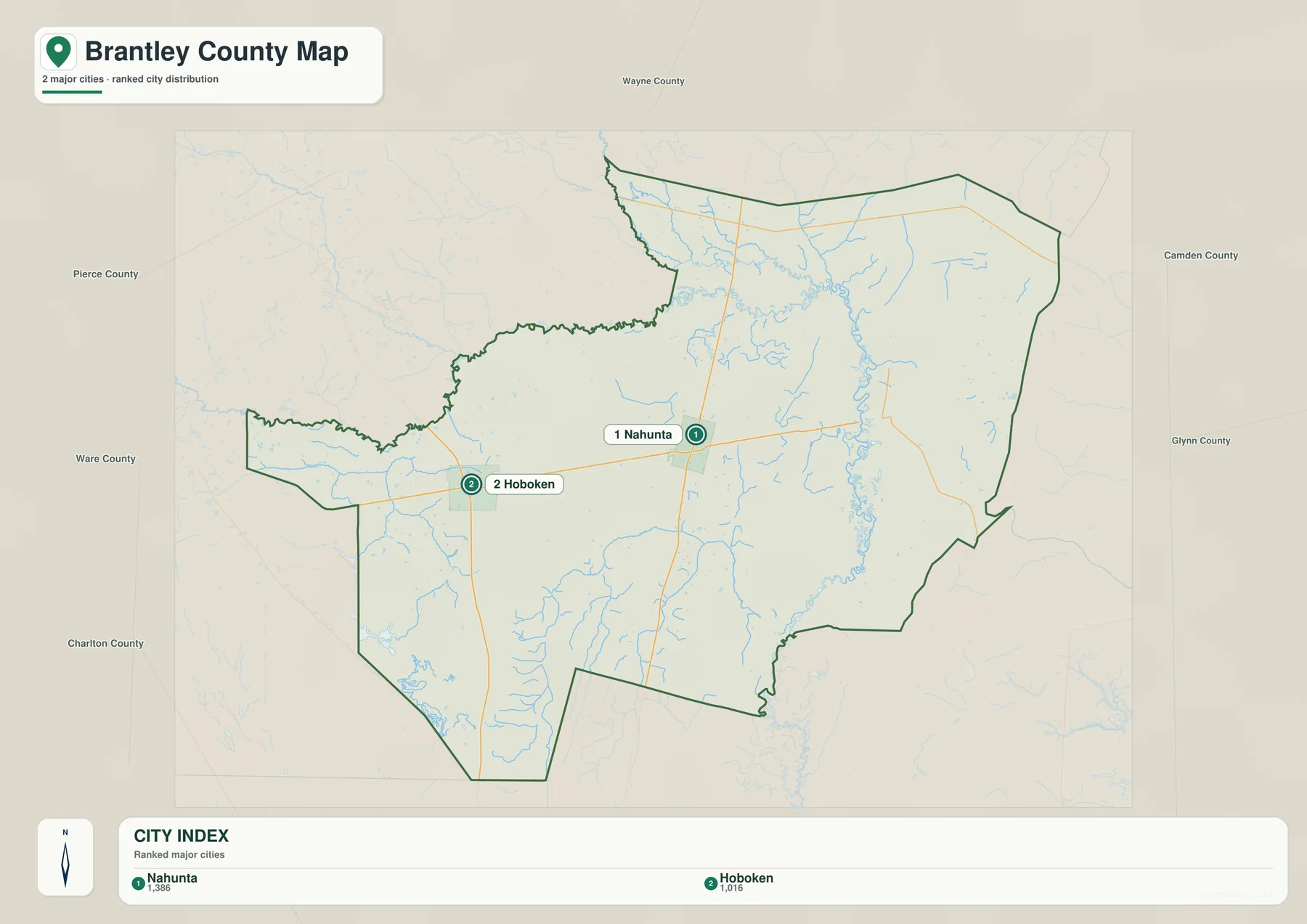
Nahunta is more than a convenient visual center. The supplied background states that Brantley County was created in 1920 with Hoboken as the original county seat, but the seat moved to Nahunta in 1923. Nahunta incorporated in 1925 and remains the county seat. On the road map, the administrative center also coincides with the junction of the county’s most obvious east–west and north–south routes. That overlap between civic function and transportation makes Nahunta the best starting point for reading the rest of the county.
Hoboken is valuable for a different reason. It represents the western incorporated center and the county’s early administrative history. On the city map it sits closer to the Pierce and Ware County sides, while on the detailed road view it is connected directly to Nahunta by US 82. A history lesson can therefore use the two points to describe the 1923 shift in the county seat, while a transportation lesson can use the same two points to establish the principal east–west corridor. This is a good example of why a simple city map can be useful even when it intentionally leaves out many smaller communities.
The Satilla and Little Satilla Waterway Network
Water becomes the dominant feature on the terrain-and-water map. The Satilla River is labeled along the northwestern and western side of the county, while the Little Satilla River occupies a complex channel system across the north and northeastern half. Several named tributaries make the map much more detailed than a general county outline. Satilla Creek, Barbers Creek, Mill Branch, and Harper Branch are labeled around the upper part of the Little Satilla system, and the branching blue lines show that many smaller channels feed into the larger waterways.
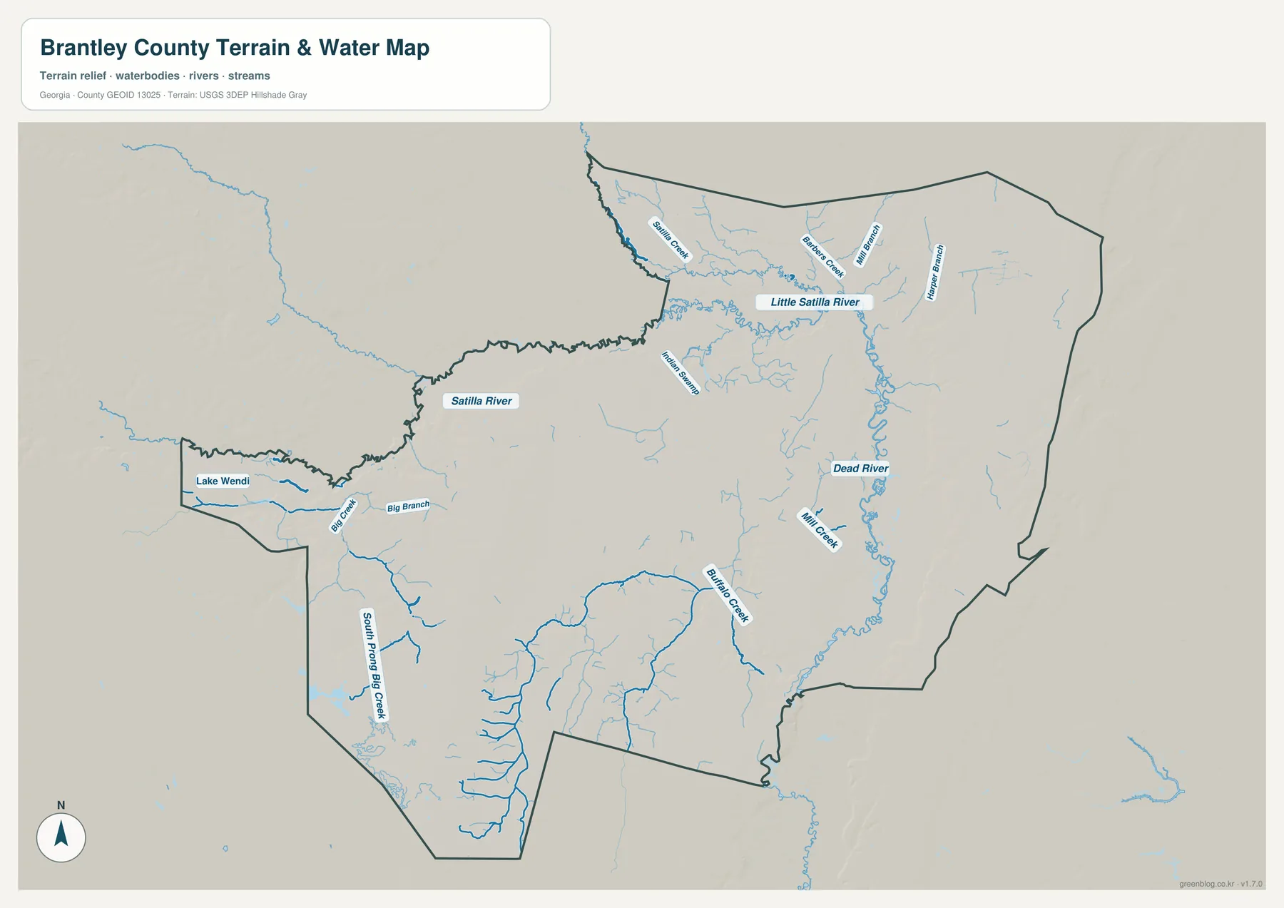
The eastern side contains another conspicuous line of water features. Dead River runs through a long north–south corridor, with Mill Creek entering from the west. Buffalo Creek makes a broad curve through the south-central and southeastern area. On the western side, Big Creek and Big Branch are labeled near the narrow extension of the county, while South Prong Big Creek continues southward through the southwestern block. Lake Wendi appears near the western edge. These features are useful because they show that Brantley County is not defined by one river alone; a network of rivers, creeks, branches, and smaller water bodies crosses the low terrain.
The supplied background links this hydrography to the character of the Satilla basin. Georgia Environmental Protection Division material cited in the original article describes the Satilla as a Coastal Plain blackwater river, where tannins and organic material from floodplain swamps darken the water. The supplied summary of the 2021 joint comprehensive plan also states that wetlands cover roughly 16 percent of the county and refers to about 90 miles of river corridor. Those figures are not measurements taken from this preview, but they provide useful context for why the water network occupies so much visual space on the map and why river and wetland planning is a recurring county issue.
This map should not be used as a flood-zone or navigation product. A blue line identifies a mapped stream or water feature; it does not tell the reader how often that place floods, how deep floodwater may become, whether a bank is publicly accessible, or whether a creek is suitable for boating or fishing. Flood insurance, emergency planning, property transactions, and engineering work require current specialized data from the relevant agencies. The purpose here is geographic orientation: identifying where named waterways lie and comparing them with roads, settlements, and terrain.
A Low Coastal Plain Landscape From About 2 to 45 Meters
The elevation map is one of the most revealing views in the set because small changes in height would be easy to miss on a normal road map. Its legend reports an actual mapped range of about 2 to 45 meters and a mean elevation of 22 meters. Those values immediately establish Brantley County as a low-elevation county. Brown and orange shades mark the relatively higher parts of the local range, while green shades represent lower ground. The western and southwestern portions contain the broadest areas of higher color, whereas lower green terrain extends through much of the north-central, northeastern, and eastern side.
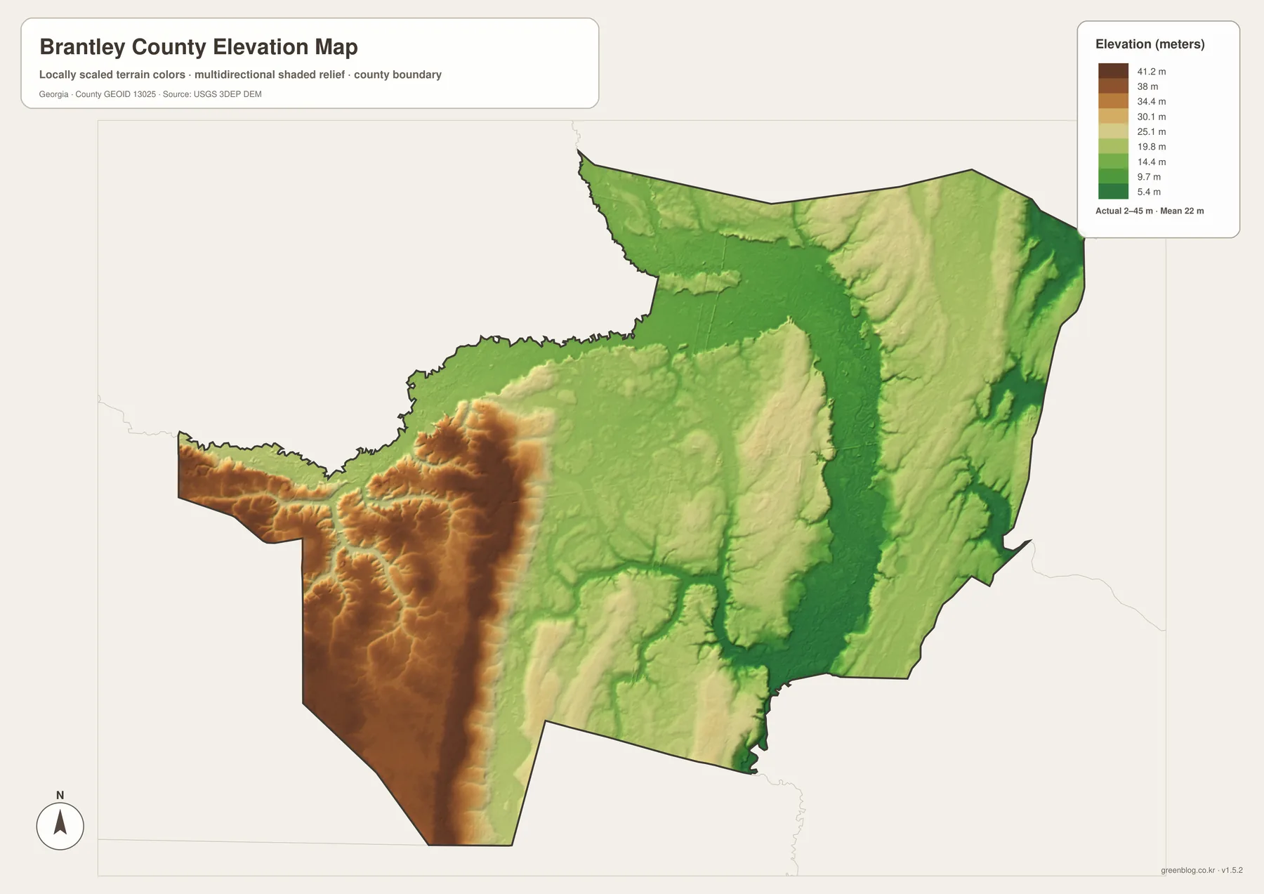
The pattern becomes easier to understand after comparing it with the water map. The Little Satilla and Dead River areas correspond to extensive lower terrain, and many tributaries occupy narrow low corridors cut into the surrounding surface. The western side around the Hoboken direction and the large southwestern block stand out as relatively higher within the county. None of this resembles mountain relief—the total local range is modest—but the shaded map makes ridges, shallow valleys, and broad lowlands visible enough to explain why waterways have such a strong presence in the county’s geography.
The elevation image is a county-scale reference, not a survey-grade model. Its colors generalize the surface so readers can compare one part of Brantley County with another. A construction elevation for a house, bridge, culvert, road, or property corner requires a more precise source. The 2–45 meter range is useful for regional explanation, classroom work, and environmental context, but it should not be turned into a site-specific engineering measurement. Keeping that limitation clear allows the map to be used for what it does well without overstating its precision.
How the Low Terrain Relates to Forests and Wetlands
The source article places Brantley County in Georgia’s lower Coastal Plain, inland from the Atlantic coast. That description fits both the low elevation range and the extensive water network visible in the new maps. The county does not have an ocean shoreline, yet it sits immediately west of coastal counties such as Glynn and Camden and east of the Waycross side of the region. Looking at the Georgia location inset and neighboring-county labels helps explain that intermediate position between the coastal corridor and the inland pine-and-wetland landscape of southeastern Georgia.
The supplied planning background repeatedly mentions forests, agricultural land, wetlands, and the Satilla–Little Satilla river area. It notes significant forest and agricultural land near Hickox, Lulaton, the Pierce County side of the Satilla, and the river confluence. These are contextual statements from the supplied material rather than land-cover percentages derived from the four new maps. The present map set does not classify every acre as forest, farm, wetland, or developed land. What it does show clearly is a lightly urbanized county with large spaces between the main settlements, many named waterways, and low terrain that helps explain the importance of wet areas and drainage corridors.
This distinction matters for readers using the maps in a report. A water map can show where a creek runs, and an elevation map can show that the surrounding area is relatively low, but neither one establishes legal wetland status or land-use zoning. Likewise, the county map can identify a nearby community without defining its exact census boundary. When the question moves from general geography to regulation, ownership, development rights, or environmental permitting, the map should be paired with current official records designed for those decisions.
From Hoboken to Nahunta: Reading County History on the Map
Brantley County’s short early administrative history adds meaning to the two-city pattern. The background supplied with the package states that Georgia created the county on August 14, 1920, from portions of Charlton, Pierce, and Wayne counties. Hoboken served as the original county seat. In 1923 the seat moved east to Nahunta, and Nahunta incorporated in 1925. That sequence can be explained with the city map in a matter of seconds because the old and current seats are the two prominent points shown in the county.
Transportation context adds another layer. The original article notes an east–west rail corridor that generally parallels the US 82 route and connects communities such as Lulaton, Atkinson, and Waynesville. The current county preview does not provide a detailed rail-operating map, so it should not be used to infer station service or track status. It does, however, show the same basic pattern of settlement along an east–west route, with Nahunta standing where the county’s clearest north–south road intersects that corridor. This relationship helps explain why the map is easier to read as a set of corridors and small centers than as a dense urban street network.
For a local-history project, start with the boundary and the two incorporated cities. Mark Hoboken as the original county seat, then move east to Nahunta for the 1923 change. Add the Satilla and Little Satilla systems if the project also discusses the natural setting, or use the elevation map to show just how low the surrounding Coastal Plain is. Keeping each map tied to a specific question produces a clearer presentation than trying to force every road, creek, historical fact, and statistic onto a single image.
Choosing the Best Map for a Brantley County Project
The four previews work best when the reader chooses them by task. The county reference map is the starting point for boundaries, numbered roads, Nahunta, Hoboken, and selected communities such as Hortense, Hickox, and Waynesville. The ranked city map is cleaner when the main question is simply where the two incorporated centers are located. The terrain-and-water map is the strongest choice for the Satilla system and the smaller creeks and branches. The elevation map adds the missing vertical dimension by showing where relatively higher and lower terrain occurs within the 2–45 meter range.
For environmental education, pairing the water and elevation maps is especially useful. Find the Little Satilla River or Dead River first, then move to the elevation view and look for the corresponding lower green terrain. Do the same with Buffalo Creek or the southwestern tributaries. For transportation or county-administration work, use the county and city maps first instead. US 82 provides the east–west framework, Nahunta supplies the principal junction and county-seat reference, and Hoboken establishes the western incorporated center.
- Use the county reference map for the boundary, Nahunta, Hoboken, selected communities, and major numbered-road orientation.
- Use the ranked city map when the main point is the relative position of Nahunta and Hoboken without extra detail.
- Use the terrain-and-water map to locate the Satilla River, Little Satilla River, Dead River, Mill Creek, Buffalo Creek, Big Creek, and smaller tributaries.
- Use the elevation map to compare the county’s roughly 2–45 meter relief and the higher western terrain with the lower river-rich east.
- Use the downloadable A3 JPG files when a larger image is needed for printing, presentations, lessons, or reports.
What the Maps Can and Cannot Establish
These maps are intended for county-scale geographic reference. They can show the overall shape of Brantley County, the location of selected communities, the direction of major numbered roads, the position of named waterways, and broad elevation differences. They cannot establish the legal location of a property line, ownership, zoning, road right-of-way, or the exact jurisdiction of a site close to the county boundary. A current county, state, or survey source is required whenever the exact line matters.
The physical maps also have clear limits. The water view does not provide flood probabilities, flood depths, insurance zones, public-access rules, or navigation conditions. The elevation surface is not a replacement for a professional survey or an engineering-grade digital elevation model for a specific project site. Their strength is comparative rather than legal or site-specific: readers can identify major rivers and tributaries, recognize lower valleys, see the higher western and southwestern terrain, and relate those features back to Nahunta, Hoboken, and the road network.
Frequently Asked Questions
Which cities are emphasized on the Brantley County city map?
Nahunta and Hoboken are the two ranked city markers. Nahunta is slightly east of the county center and serves as the county seat, while Hoboken lies to the west along US 82. The detailed county map also labels places such as Hortense, Hickox, and Waynesville, but the city view keeps the focus on the two incorporated centers.
Can the Brantley County water map be used to determine flood risk?
No. It is a geographic reference for the Satilla River, Little Satilla River, Dead River, Mill Creek, Buffalo Creek, Big Creek, and other waterways. It does not show flood probability, expected depth, insurance zones, parcel boundaries, or public access. Those questions require current specialized flood and property data.
What does the 2–45 meter elevation range mean?
The supplied elevation map reports a mapped range of about 2 to 45 meters and a mean of 22 meters. Those figures help compare higher local ground in the west and southwest with lower terrain toward the river-rich eastern side. They are county-scale reference values, not survey measurements for an individual property or construction site.
Map File Information
Brantley County A3 map files
- Included Files: County, city, water, and elevation maps
- File Type: Four high-resolution A3 JPG files in one ZIP archive
- Intended Use: Printing, education, presentations, and map-based projects
Related Maps
Sources and References
- U.S. Census Bureau QuickFacts — population and land-area context for Brantley County
- Brantley County’s official resident and recreation information — local county information
- Georgia Department of Community Affairs planning records — county, Nahunta, and Hoboken planning context
- Georgia Environmental Protection Division, Lower Satilla River Basin Watershed Improvement Plan — Satilla watershed context
- USGS 3D Elevation Program — official elevation-data reference
Green Map creates custom-edited map images using open geographic data sources such as geoBoundaries, Natural Earth, OpenStreetMap, and government open data. These maps are edited visual materials, not raw data files, and are provided for education, documents, presentations, and graphic reference.