If you need a practical map of Brooks County, Georgia, this page brings the county boundary, Quitman, Morven, Pavo, Barwick, major roads, named waterways, and local relief into one set. Four WEBP previews are provided for quick viewing, and a downloadable ZIP contains four high-resolution A3 JPG files for printing, classroom use, presentations, or document layouts. Quitman is the easiest place to orient yourself because the county seat sits near the south-central part of Brooks County at the US 84 and US 221 junction. From there, the other mapped towns, river corridors, and changes in elevation are easier to place.
Brooks County reaches the Florida line along southern Georgia and has a much more irregular eastern edge than its straighter southern boundary. The county map places Morven northeast of Quitman, Pavo in the northwest, and Barwick near the western county line. The water map adds Little River, Okapilco Creek, Piscola Creek, Mule Creek, Little Creek, several ponds and lakes, and the Aucilla River label near the southwest. The elevation preview reports an actual mapped range of about 19 to 86 meters with a mean of 54 meters. That is a modest range, but the shaded relief makes the county’s low stream corridors and gently higher ground surprisingly clear.
Table of Contents
Start with Quitman, the road network, and the county outline
Quitman provides the strongest reference point on the general county map. The supplied article data identifies it as the county seat and notes that east–west US 84 meets north–south US 221 there. The preview also shows route shields for 38, 76, 333, 122, and 133 in different parts of the county. This is not a turn-by-turn highway map, but those routes are enough to understand the main directions of travel: an east–west route through Quitman, northbound connections toward Morven and the upper county, and additional state routes reaching the Pavo area and northeastern Brooks County.
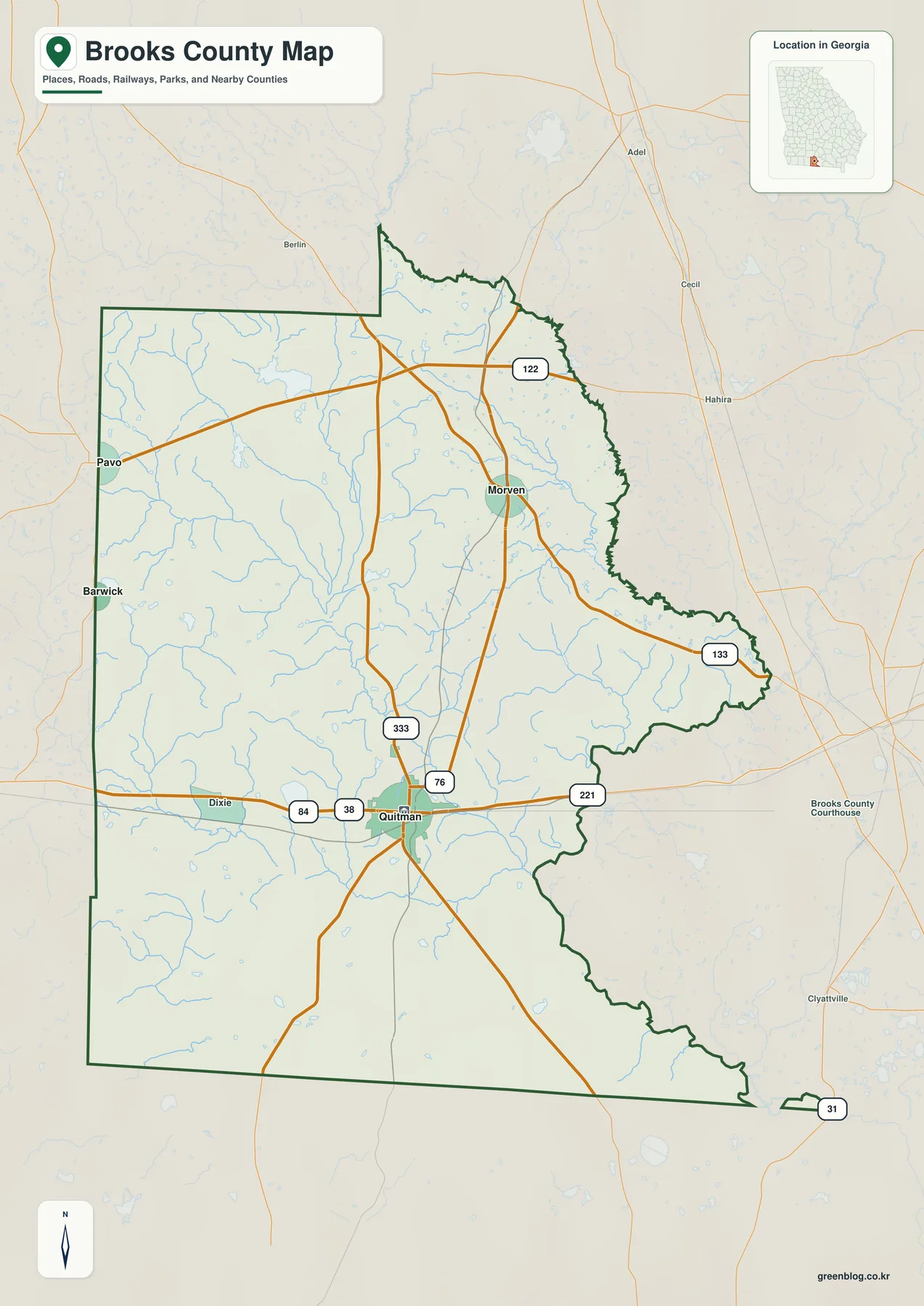
Morven appears northeast of Quitman, while Pavo occupies the northwestern side and Barwick sits farther south along the western edge. The previous county material states that Pavo and Barwick extend across the Brooks–Thomas county line. For that reason, the city labels should be read as representative locations rather than exact municipal polygons. Anyone who needs a precise city limit, parcel boundary, zoning line, or property jurisdiction will need a dedicated municipal or parcel dataset instead of relying on the point label shown here.
The broader setting matters as well. The supplied background identifies Cook County to the northeast, Lowndes County to the east, Thomas County to the west, Colquitt County to the northwest, and Florida counties along the south. The city preview also labels several surrounding counties outside the Brooks outline. That context helps explain why Quitman can be read as a south Georgia crossroads rather than an isolated town: US 84 continues toward the Valdosta area on one side and toward the Thomasville direction on the other, while routes running north and south connect the county with Florida and inland Georgia.
| State | Georgia |
|---|---|
| County seat | Quitman |
| Mapped towns | Quitman, Morven, Pavo, and Barwick |
| Created | December 11, 1858 |
| 2020 Census population | 16,301 |
| 2025 population estimate | 16,101 |
| Land area | 493.18 square miles |
| 2020 population density | 33.1 people per square mile |
| County FIPS code | 13027 |
| Mapped elevation range | About 19–86 m; mean 54 m |
| Download | ZIP with four high-resolution A3 JPG maps |
The population, land-area, creation-date, and FIPS values above come from the material supplied with the rewrite package. The relatively low 2020 population density is useful when reading the map because the spacing between Quitman and the smaller towns is not simply a design choice. Brooks County contains broad rural areas between municipal centers. Roads, creeks, ponds, agricultural land, forest, and smaller unincorporated communities occupy much of the space that a simple city map leaves visually open.
How Quitman connects with Morven, Pavo, and Barwick
The city map strips away much of the background detail and turns the four labeled places into an easy orientation diagram. Quitman is marker 1 and is identified as the hub. Pavo is marker 2 in the northwest, Morven is marker 3 to the northeast, and Barwick is marker 4 on the western side. The CITY CONNECTIONS panel prints direct distances from Quitman of about 12 miles to Morven, 13 miles to Barwick, and 16 miles to Pavo. Those values are particularly useful for understanding scale because the towns can otherwise look closer together on a full-county page than they are on the ground.
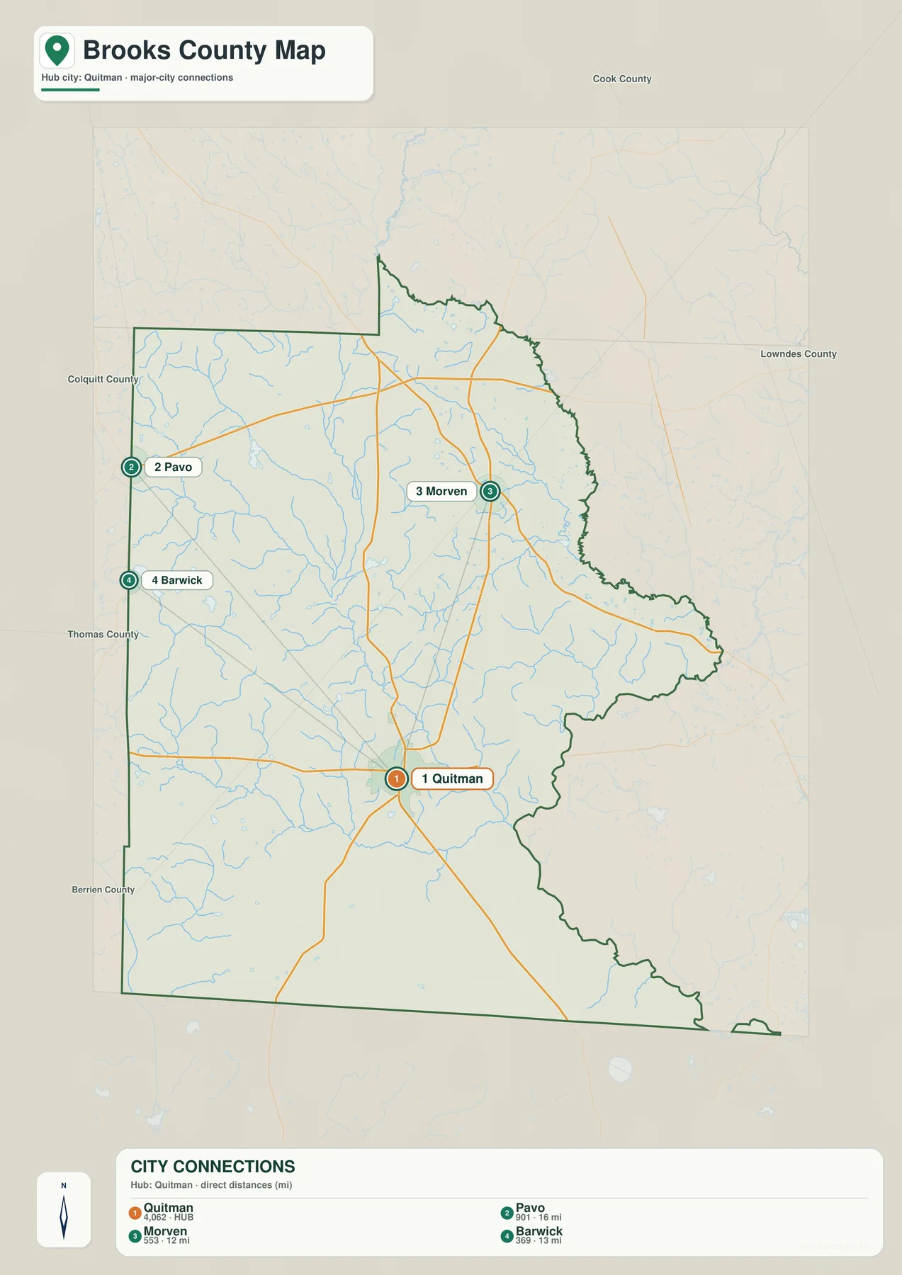
The lower panel also prints the numbers 4,062 for Quitman, 901 for Pavo, 553 for Morven, and 369 for Barwick. Because the preview does not state the statistical year or define those figures, this article treats them only as values printed on the map rather than as current Census estimates. The spatial relationship is more dependable for this page’s purpose: Quitman is the south-central administrative and road hub, while the three smaller mapped municipalities are distributed across the northern and western parts of the county.
The earlier Brooks County article also names Dixie, Barney, Grooverville, and Pidcock as unincorporated places. Their omission from the city preview is therefore a matter of map selection, not evidence that those communities are absent. A county-scale city map has to choose which labels to emphasize. For local-history research, address finding, emergency routing, or detailed community geography, pair this overview with a current street map or official place-name source.
Little River, Okapilco Creek, and a dense network of smaller waters
The terrain-and-water map changes the emphasis completely. Little River is labeled along the eastern side, while Slaughter Creek appears in the northeast. Okapilco Creek is one of the strongest interior features, running through the central portion of the county toward the southeast. Piscola Creek extends across the southern half. Rather than showing only one dominant river, the preview reveals many branches and small tributaries, which helps explain the repeatedly indented stream corridors that appear throughout Brooks County.
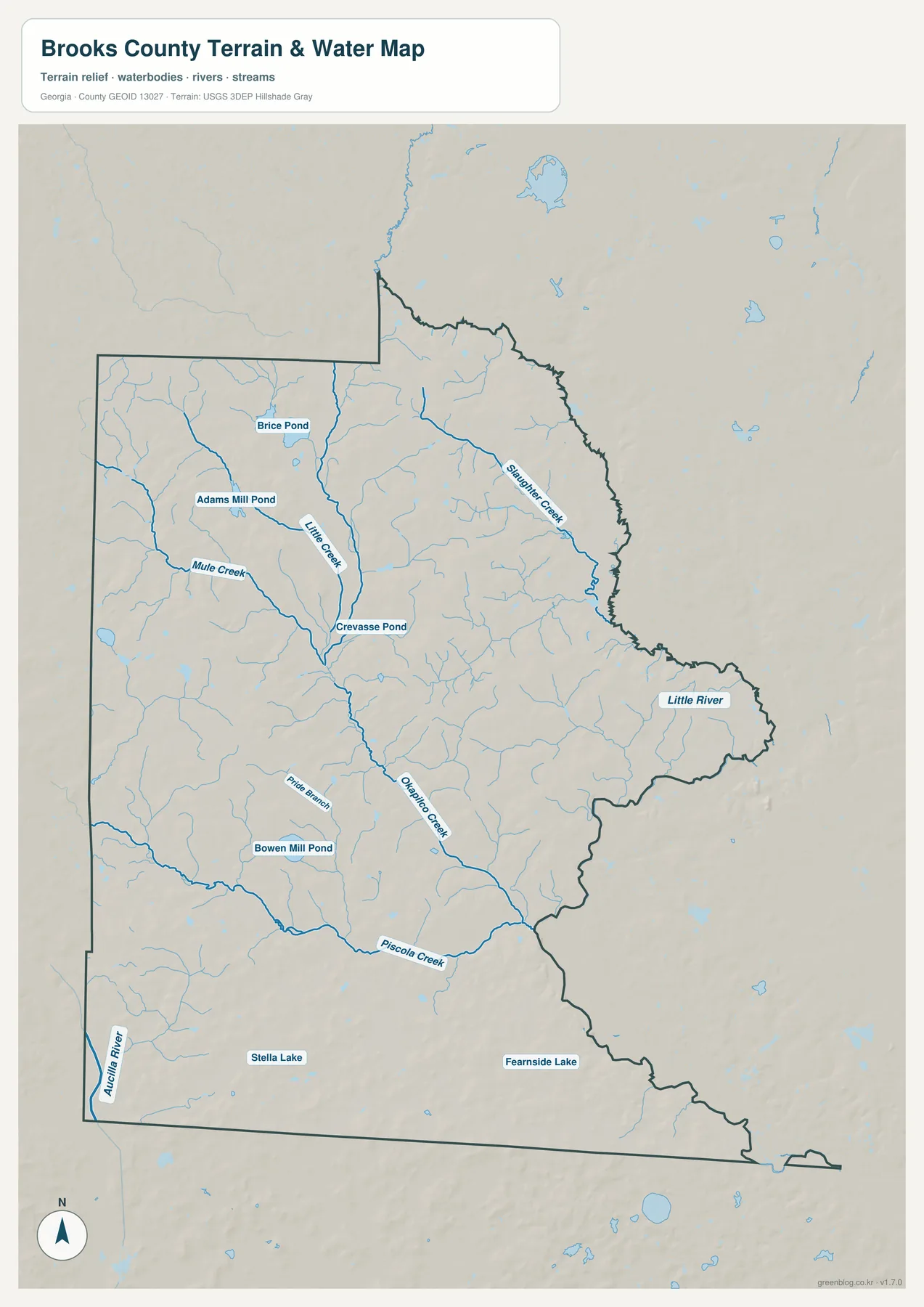
The northwestern and central parts of the map include Mule Creek and Little Creek, along with Brice Pond, Adams Mill Pond, and Crevasse Pond. Farther south, Pride Branch and Bowen Mill Pond appear before Piscola Creek crosses the county. Stella Lake is labeled near the southern portion, Fearnside Lake lies farther east, and Aucilla River appears along the southwestern edge. These names make the map useful for more than a generic “rivers in Brooks County” illustration because a reader can connect individual local water features with their approximate county position.
Blue lines should not be confused with a flood-hazard layer. The map shows water locations and terrain context; it does not show FEMA flood zones, expected flood depth, public access, navigability, fishing rights, or ownership. A parcel near Little River or Okapilco Creek may require much more detailed hydrologic and legal information. Use this overview to identify the larger setting, then consult current official flood, hydrography, road, and property sources for decisions that depend on precision.
What the 19–86 meter elevation range reveals
The elevation preview gives a concise numerical summary: an actual mapped range of roughly 19 to 86 meters and a mean of 54 meters. Brooks County is not mountainous, but the shaded relief shows that “flat south Georgia” still contains numerous low corridors, shallow valleys, and gently raised ridges. Browns and oranges are more common across parts of the west, northwest, and northern interior, while greener low ground forms long channels through the central and eastern areas.
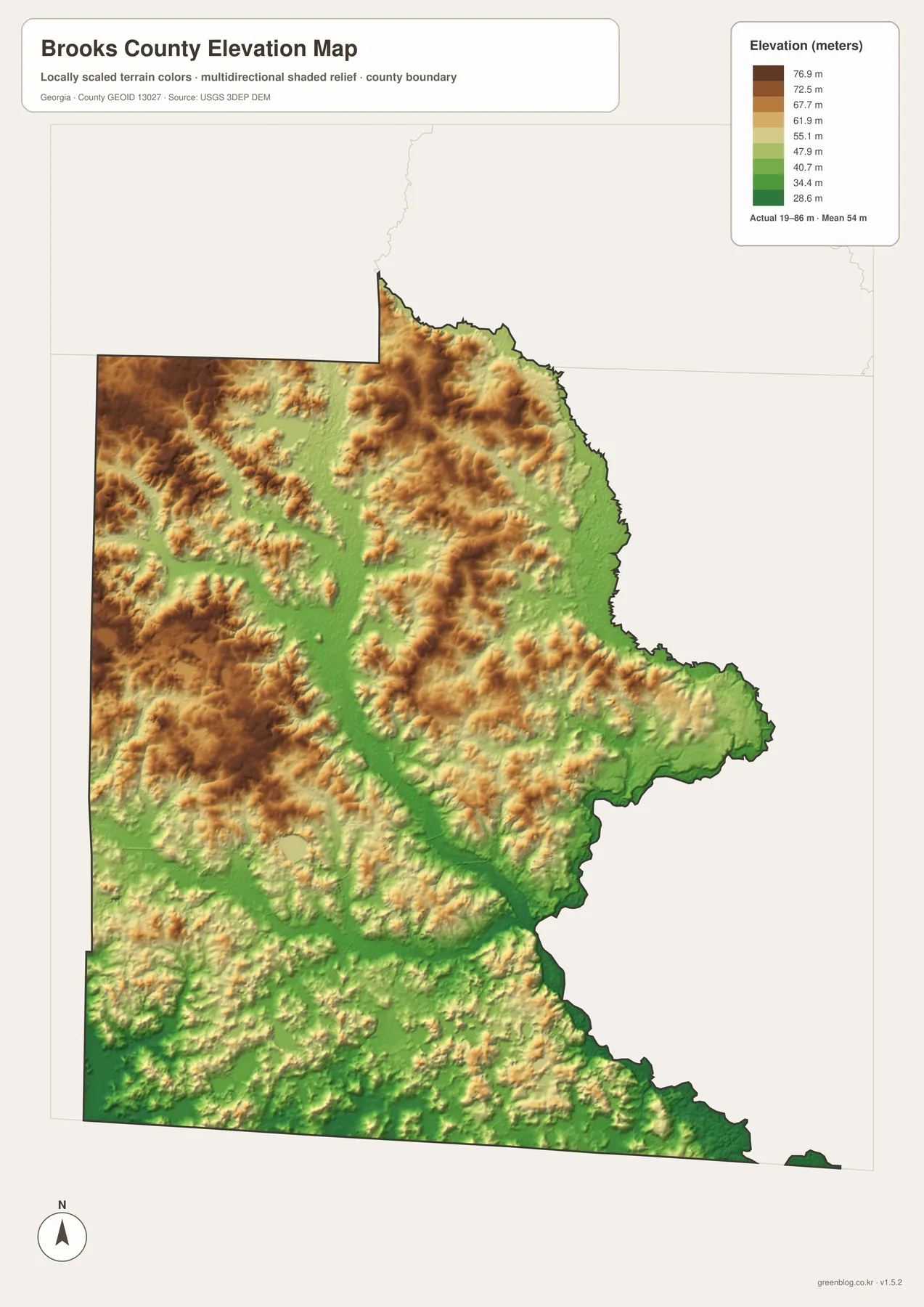
Switching back and forth between the water and elevation maps is especially informative. Lower green corridors generally follow the same broad areas where streams and tributaries are concentrated, including parts of the Little River side and the Okapilco Creek drainage through the interior. Higher colors appear as broken, gently rolling bands rather than as one continuous ridge. The result is a landscape of modest relief where drainage pathways can still shape the appearance of the county even though absolute elevation remains low.
The color ramp is locally scaled for Brooks County, so a brown area should be read as higher relative to other places in this county, not as a mountain in a statewide sense. The image is also not a survey-grade surface. It cannot establish the elevation of a house foundation, the grade of a road, the slope of a drainage ditch, or engineering requirements for construction. For classroom geography, regional orientation, watershed context, and general terrain comparison, however, the map is much more informative than a plain boundary outline.
The Florida border, rural settlement, and Brooks County’s local context
The background material supplied with this package says the Georgia legislature created Brooks County from parts of Lowndes and Thomas counties on December 11, 1858. Quitman was chosen as the county seat at formation. A temporary courthouse opened in 1859, and the permanent courthouse completed in 1864 remains an important administrative landmark in central Quitman. That history helps explain why the city carries more visual and practical weight on the map than the other labeled municipalities.
The same source material describes pecans, peanuts, cotton, soybeans, cucumbers, beef cattle, and dairy cattle among the county’s agricultural activities. That list fits the broad rural spacing visible between the mapped towns, though these four maps are not land-cover or crop-distribution products and should not be used to calculate acreage. The useful point is broader: Brooks County is a large, lightly populated south Georgia county where farms, forest tracts, streams, wetlands, and small communities occupy much of the landscape outside Quitman.
The Florida line adds another geographic frame. It is comparatively straight along the southern edge, while the county’s eastern side bends around river and drainage features. Roads leaving Quitman connect southward toward the state line and outward to nearby Georgia centers. On the water map, Stella Lake and the Aucilla River label reinforce the fact that the southern part of the county belongs to a different border-and-watershed context than the upper interior. This contrast between administrative lines and natural corridors is one of the most useful things to point out when teaching from the map.
Choose the map that matches the question, then download the A3 set
Each preview is strongest at a different task. The general county map is best for the outline, Quitman, road shields, and overall orientation. The city map simplifies the page to show how Morven, Pavo, and Barwick relate to the county-seat hub. The water map is the choice when a creek, river, pond, or lake name matters. The elevation map adds terrain context by showing where those drainage corridors sit within the county’s 19–86 meter range. Using two maps together is often more useful than trying to force every detail into one image.
- Use the county map for Quitman, Morven, Pavo, Barwick, major routes, and the county boundary.
- Use the city map for the hub-and-town layout and the direct distances printed from Quitman.
- Use the water map to locate Little River, Okapilco Creek, Piscola Creek, smaller tributaries, ponds, and lakes.
- Use the elevation map for the 19–86 m range, 54 m mean, low stream corridors, and gently higher ground.
- Use the A3 JPG archive when you need larger files for print, slides, reports, or classroom materials.
Keep the original aspect ratio when placing a JPG into a document or slide deck. If you need a smaller image on screen, reduce its display size rather than stretching it. Road names, county lines, water labels, and elevation colors are intended for reference at county scale. A current navigation map, municipal boundary layer, parcel database, or engineering elevation source is the right next step when the task requires a level of detail that these printable maps do not provide.
What these county-scale maps do not establish
The set is designed for geographic orientation, not legal or engineering decisions. None of the images establishes parcel ownership, deed boundaries, zoning, building footprints, exact municipal limits, road closures, traffic conditions, or rights of access. This matters near the Brooks–Thomas county line, where the supplied background notes that Pavo and Barwick cross the county boundary. A town label can orient the reader while still being far too general to determine which side of a municipal line a particular property occupies.
Natural-hazard interpretation needs the same caution. A creek on the water map is not a flood-zone polygon, and a green low area on the elevation map is not automatically a flooded or flood-prone parcel. Flood insurance, construction, emergency planning, real-estate transactions, and drainage design require current authoritative data and, in many cases, professional surveying or engineering. The Brooks County map set works best as the countywide overview that tells you where to focus before moving to those specialized sources.
Frequently Asked Questions
Which towns are emphasized on the Brooks County city map?
Quitman is the hub, with Pavo, Morven, and Barwick placed around it. The panel lists direct distances of roughly 12 miles to Morven, 13 miles to Barwick, and 16 miles to Pavo. The older county material also identifies additional unincorporated communities that are not part of this simplified four-place city display.
Which waterways stand out on the water map?
Little River, Okapilco Creek, and Piscola Creek are strong orientation features. The map also labels Mule Creek, Little Creek, Slaughter Creek, Aucilla River, Brice Pond, Adams Mill Pond, Crevasse Pond, Bowen Mill Pond, Stella Lake, and Fearnside Lake. The map is descriptive and does not replace flood, access, or navigation information.
What elevation range does the Brooks County preview show?
The legend reports an actual range of about 19 to 86 meters and a mean of 54 meters. Higher colors occur more often in parts of the west and north, while lower corridors follow major drainage areas through the central and eastern county. These are county-scale terrain values, not survey elevations for individual properties.
Map File Information
Brooks County A3 map files
- Included Files: County, city, water, and elevation maps
- File Type: Four high-resolution A3 JPG files bundled in one ZIP archive
- Intended Use: Printing, education, presentations, and map-based projects
Related Maps
Sources and Reference Data
- U.S. Census Bureau QuickFacts — county population and land-area reference
- Brooks County official profile — county history and local background
- Georgia Department of Community Affairs comprehensive-plan record — planning context for Brooks County and its municipalities
- U.S. Census Bureau TIGER/Line — boundary and road reference data
- USGS National Hydrography — water-feature reference data
- USGS 3D Elevation Program — elevation reference data
Green Map creates custom-edited map images using open geographic data sources such as geoBoundaries, Natural Earth, OpenStreetMap, and government open data. These maps are edited visual materials, not raw data files, and are provided for education, documents, presentations, and graphic reference.