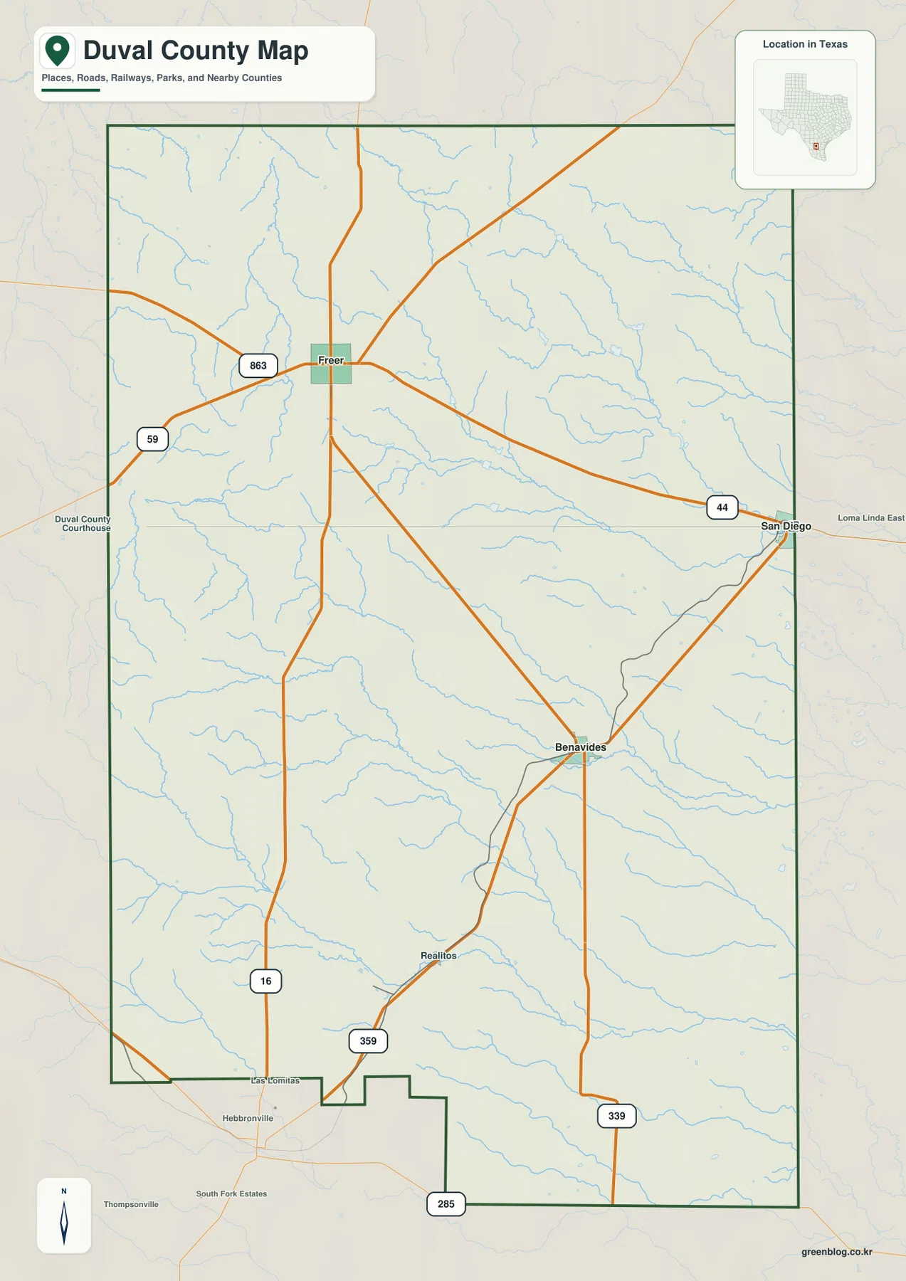
Duval County in South Texas becomes much easier to understand when Freer, San Diego, Benavides, and Realitos are located before the smaller roads and creeks are examined. The general county map shows a strong east-west connection between Freer and San Diego along the road marked 44, while Benavides and Realitos sit farther south. The water map adds San Diego Creek, Rosita Creek, Concepcion Creek, and many smaller drainages, and the elevation map shows a clear change from higher ground in the west and southwest to lower terrain in the east. This Duval County Map page brings those views together, and matching high-resolution A3 JPG files can be downloaded as one ZIP from the map file box below.
Each supplied map answers a different practical question without requiring the reader to treat the county as a single uniform landscape. The county map is best for roads, boundaries, and named communities. The city-connections view reduces the scene to San Diego, Freer, and Benavides so direction and spacing are easy to compare. The terrain-and-water map reveals how many named creeks cross the county, while the elevation map makes the west-to-east relief change immediately visible. Using the same locations as reference points across all four maps provides a more concrete picture than a generic description of South Texas brush country.
Table of Contents
Freer, San Diego, and the county’s main road pattern
The most obvious road relationship on the general map is the connection between Freer and San Diego. Route 44 runs across the county between the two communities, and route 16 passes north-south through the Freer area before continuing toward the southern part of the county. San Diego sits near the eastern side of Duval County, while Benavides lies southwest of it and Realitos appears farther south. Routes labeled 359, 339, and 285 help define the southern network. Rather than reading the road numbers as a list, it is more useful to remember the sequence of places: Freer in the west-central area, San Diego to the east, Benavides below them, and Realitos farther south.
The county boundary is fairly simple along much of the north and east, but the southern edge includes several steps and projections. Roads do not mirror that outline; they cross the interior toward the settlements and junctions that matter locally. The Freer area has several roads branching in different directions, while San Diego and Benavides also serve as visible road reference points. Large spaces between those communities contain fewer major road lines. This map is therefore useful for orientation and regional layout, but it is not a substitute for current navigation, road-condition, or travel-time information.
San Diego as the hub for Freer and Benavides
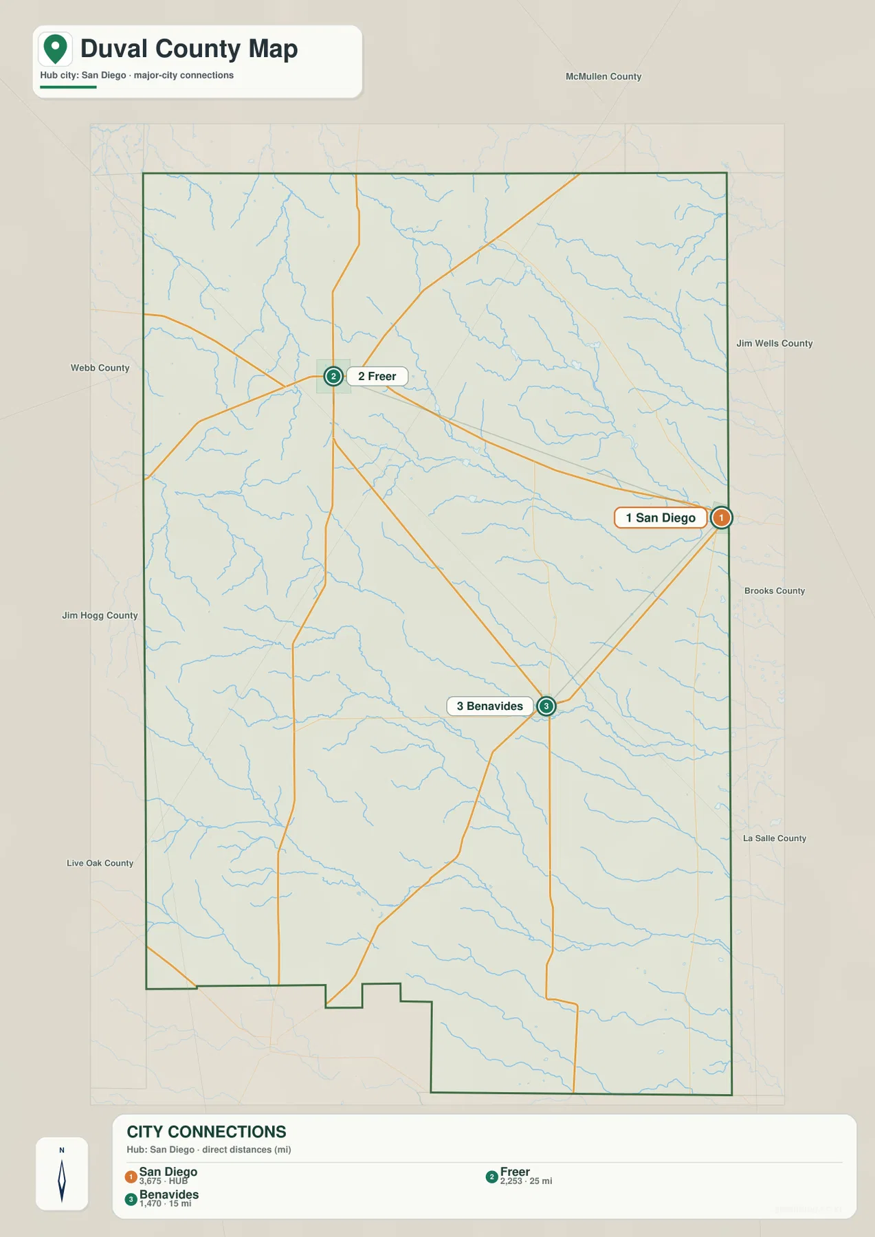
The city-connections map uses San Diego as the hub and draws direct links to Freer and Benavides. The information panel gives a straight-line distance of about 25 miles from San Diego to Freer and about 15 miles from San Diego to Benavides. Those values are not driving distances, so the actual mileage on public roads can be longer. The useful part of the graphic is the directional relationship: Freer is west-northwest of San Diego, whereas Benavides lies to the southwest.
This simplified view also shows why Duval County should not be pictured as one continuous urban area. San Diego occupies the eastern side, Freer is separated by a broad rural area to the west, and Benavides forms another reference point farther south. The general county map restores Realitos and the additional roads that the connections graphic intentionally leaves out. Reading the two maps together gives both a quick hub-and-distance view and a fuller picture of the county’s settlements. Labels outside the county frame are secondary context, so the discussion here relies on the mapped places and connections inside Duval County.
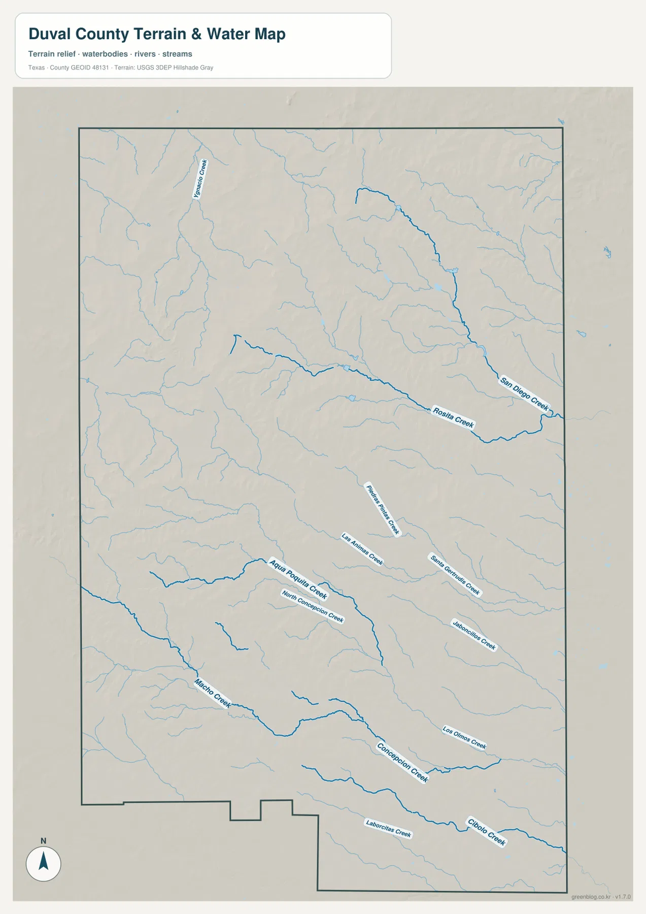
San Diego Creek, Rosita Creek, and the southern drainages
The terrain-and-water map is dominated by creeks rather than by a single large lake or river. San Diego Creek is a prominent named channel on the eastern side, and Rosita Creek extends across the central part of the county toward it. Violeta Creek is labeled in the northwest. Farther south, the map shows Baluarte Creek, Las Animas Creek, Santa Gertrudis Creek, Jaboncillos Creek, Agua Poquita Creek, North Concepcion Creek, Concepcion Creek, Los Olmos Creek, Cibolo Creek, and Laborcitas Creek. The number of named channels makes the county’s drainage network one of the clearest differences between this map and the general road map.
The creek names are most useful when they are tied back to the communities. After finding the Freer-to-San Diego corridor on the county map, the water map can be used to locate Rosita Creek and San Diego Creek in the central and eastern part of the county. In the south, remembering the positions of Benavides and Realitos makes it easier to place Concepcion Creek, Cibolo Creek, and the other drainages. The blue lines indicate mapped waterways, but they should not be interpreted as a promise of constant year-round flow or as a flood-risk boundary. Current hydrologic or flood information should be checked separately for those purposes.
Higher western ground and the lower eastern side
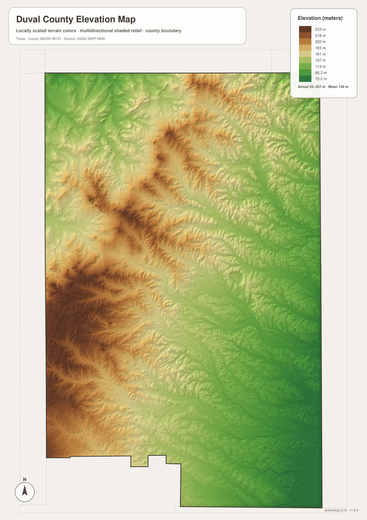
The elevation map adds a feature that is difficult to see on the road map: Duval County has a substantial west-to-east change in height. The legend reports an actual range of roughly 53 to 257 meters, with a mean near 149 meters. Brown and tan colors occupy much of the western and southwestern side, including broad areas above 200 meters. Greens become more common toward the east, where large areas fall into lower elevation bands. The contrast is especially clear when the southwest corner is compared with the eastern county line.
The surface is not a simple tilted plane. Short ridges and narrow valleys create a textured pattern across the higher western half, while the lower eastern side contains broader green areas crossed by drainage lines. Comparing this map with the water map helps explain why many creeks occupy low channels cutting through the terrain. The elevation layer is intended for county-scale comparison; it should not be used as a survey for a parcel, building site, road design, or engineering decision. For those tasks, the original elevation datasets and project-specific measurements are more appropriate.
Using the maps together without losing the local details
For road and place-name questions, begin with the general county map. Find Freer, San Diego, Benavides, and Realitos, then follow route numbers such as 44, 16, 359, and 339. If the question is simply how the main communities are oriented, the city-connections map provides a cleaner comparison from San Diego to Freer and Benavides. For natural features, switch to the water map and trace San Diego Creek, Rosita Creek, and Concepcion Creek before checking the same locations on the elevation map.
A practical example is the Freer-to-San Diego portion of the county. The road map first establishes the Route 44 connection. The water map then shows Rosita Creek and San Diego Creek in the central and eastern area, and the elevation map reveals that the western side around Freer is generally higher than the eastern side near San Diego. The same method works in the south: locate Benavides and Realitos, identify the roads around them, then compare the positions of Concepcion Creek and Cibolo Creek with the lower elevation colors. Repeating the same location across the maps makes the county’s differences easier to understand than reading four isolated map descriptions.
The maps also serve different presentation needs. A classroom or printed reference focused on communities and routes may need only the general map, while a discussion of drainage is clearer with the terrain-and-water version. The elevation map is useful when the goal is to show why western and eastern Duval County do not have the same relief. Because all four images use the same county boundary, they can be placed side by side without having to relearn the outline each time.
Frequently Asked Questions
How are San Diego and Freer connected on the map?
The general map shows Route 44 running between Freer and San Diego. The city-connections map places Freer about 25 miles from San Diego by straight-line distance; actual road mileage depends on the route and exact endpoints.
Which waterways stand out in Duval County?
San Diego Creek and Rosita Creek are prominent in the central and eastern part of the water map. Farther south, Concepcion Creek and Cibolo Creek are among the many named drainages crossing the county.
Where is Duval County highest and lowest on the supplied elevation map?
The west and southwest are generally higher, while the eastern side is lower. The legend gives an overall elevation range of about 53 to 257 meters, intended for broad county-scale comparison rather than site surveying.
Sources and Reference Data
The following official resources can be used to examine the boundary, hydrography, and elevation data in more detail.
- USGS The National Map Viewer — Interactive access to U.S. topographic and geographic layers.
- U.S. Census Bureau TIGER/Line Shapefiles — Official boundary and geographic line datasets.
- USGS National Hydrography — U.S. surface-water and hydrography information.
- USGS 3D Elevation Program — National elevation data and 3DEP information.
Map File Information
Download the high-resolution A3 JPG versions that match the Duval County maps shown on this page.
- Included Files: County map, city map, water map, elevation map
- File Type: JPG
Related Maps
- Webb County Texas map
- Starr County
- Zapata County Texas map
- San Patricio County Texas map
- Atascosa County Texas map
Green Map creates custom-edited map images using open geographic data sources such as geoBoundaries, Natural Earth, OpenStreetMap, and government open data.
These maps are edited visual materials, not raw data files, and are provided for education, documents, presentations, and graphic reference.