Livingston County stretches across north-central Illinois with Pontiac near the middle, Dwight and Odell toward the northeast, and Fairbury, Forrest, and Chatsworth spread across the southern part of the county. The road map makes Pontiac a useful reference point because several routes meet or pass close to the city, while the water map shows a different structure: branches of the Vermilion River and a web of smaller creeks cut across the county from northwest to southeast.
This page lets you compare those patterns on four separate maps. The boundary and road map gives the broad orientation, the city map highlights six ranked communities, the terrain and water map isolates rivers and creeks, and the elevation map shows where the county rises and falls. High-resolution JPG versions of all four maps are also available here as one ZIP download, so you can move from quick on-screen reference to a larger file for printing or close inspection.
Table of Contents
Pontiac as the county’s road and settlement reference point
Pontiac is the clearest anchor on the general county map. From the city, Interstate 55 runs northeast toward Odell and Dwight, while Illinois Route 116 heads east toward Saunemin and Cullom. Route 23 crosses the Pontiac area north to south. To the northwest, Cornell and Long Point occupy a different part of the county, and Flanagan sits west of Pontiac. The southern boundary brings another group of places into view, including Fairbury and Chatsworth.
The numbered roads help explain why the communities appear in distinct groups rather than as one continuous urban area. Route 17 crosses the northern part of the county, I-55 follows the northeast corridor, and Route 24 crosses near Fairbury in the south. Roads labeled 47, 800, 820, 825, and 830 are visible around the southern and southeastern communities. This map is best used for geographic orientation, not turn-by-turn driving directions, because its purpose is to show the relationship among towns, county boundaries, roads, and nearby places.
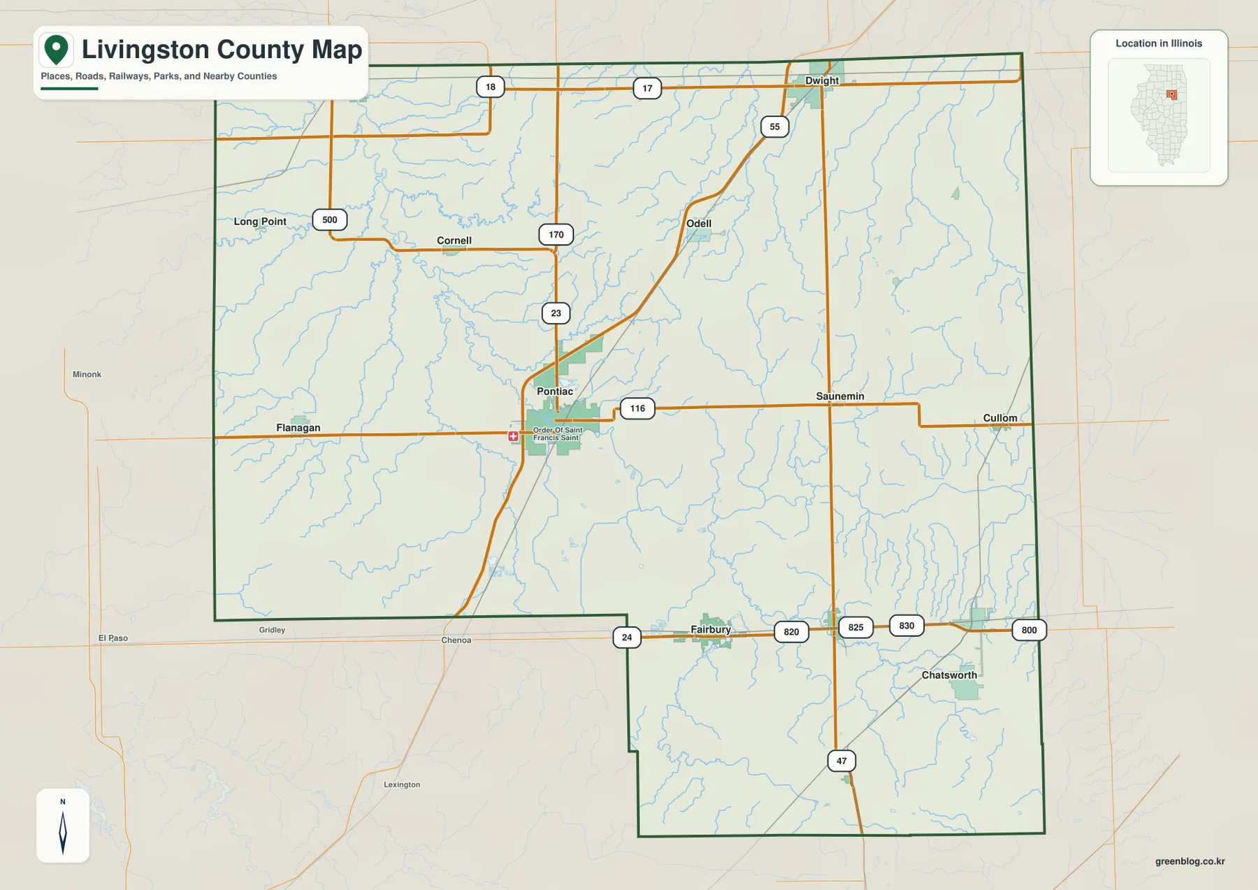
The county outline is also useful in its own right. Most of Livingston County forms a large northern block, but the boundary steps southward near Fairbury and then continues through a southeastern projection that contains Chatsworth. That shape explains why some communities that look close on a statewide map can sit in very different parts of the county. Dwight is close to the northern edge, Pontiac occupies the interior, and Chatsworth lies far down in the southeastern extension.
Six major communities split between the center, northeast, and south
The city map ranks six places and makes their spacing easy to compare. Pontiac is first at 11,294, followed by Dwight at 3,872 and Fairbury at 3,713. Chatsworth is shown at 1,172, Forrest at 994, and Odell at 890. The ranking is only part of the story. Pontiac stands by itself near the center, Dwight and Odell form the northeastern pair, and Fairbury, Forrest, and Chatsworth line up across the southern part of the map.
That southern group is especially clear. Fairbury sits toward the southwest side of the county’s southern edge, Forrest lies farther east, and Chatsworth occupies the southeastern portion. In the north, Dwight is close to the county line while Odell lies southwest of it along the I-55 corridor. Pontiac separates the northern and southern groups and therefore works well as a central reference when explaining distances or directions within Livingston County.
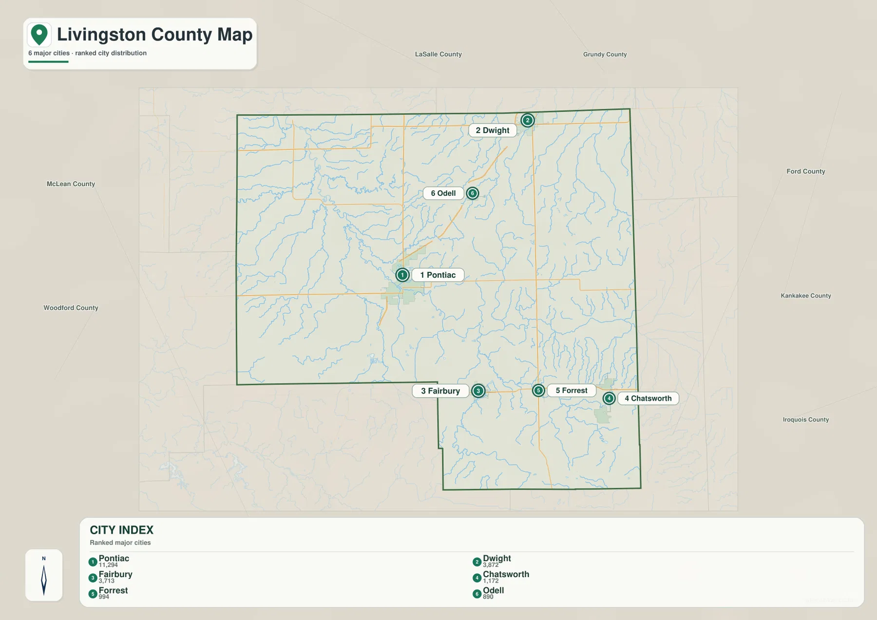
For a classroom handout or county profile, this map works better than a long list of place names because it keeps the relative positions visible. It is also useful when paired with the road map. The city map tells you where the six communities are, while the general map shows which numbered roads connect their parts of the county. The two together give a clearer picture than either map alone.
Vermilion River branches and smaller creeks across the county
Water is spread through Livingston County in a branching network rather than around one large lake. The Vermilion River appears in the northwestern portion of the map, while the North Fork Vermilion River crosses the central and eastern part of the county. Farther south, the South Fork Vermilion River runs through the extended southeastern section. Together, these channels create a clear northwest-to-southeast relationship that is harder to see on the road map.
Several named tributaries fill in the smaller-scale pattern. Long Point Creek lies in the northwest, with Short Point Creek, Saunemin Creek, Rooks Creek, Wolf Creek, and Pike Creek in the western and central areas. The northeast includes the West Fork Mazon River and Gooseberry Creek, while Five Mile Creek is labeled farther east. Indian Creek and Turtle Pond appear in the southern extension. These features show why the county’s surface is not uniformly flat even though it lacks mountain terrain.
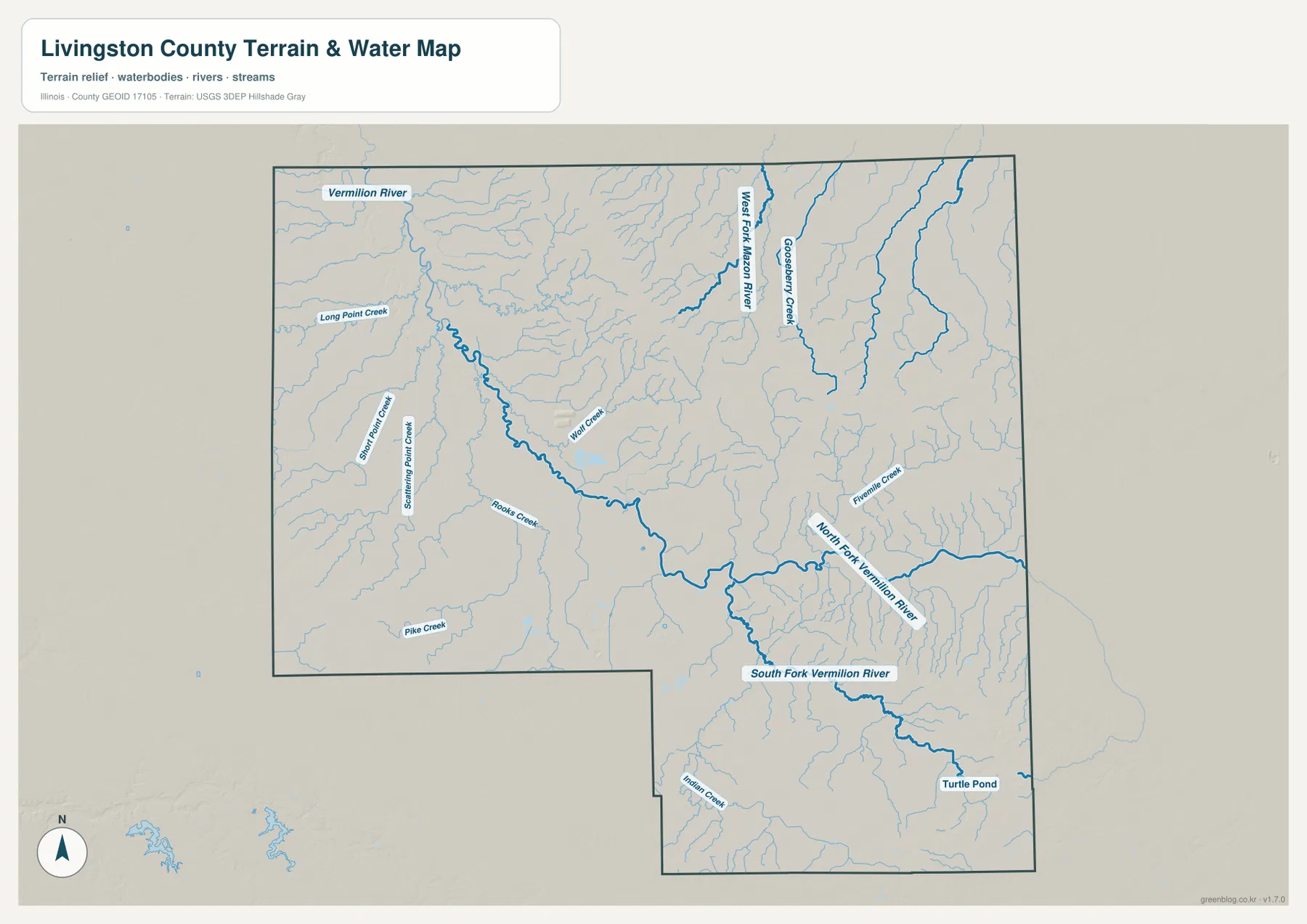
This is a reference map for waterways and surrounding terrain, not a flood-risk, parcel, legal-boundary, or navigation product. Its value is in showing where the channels lie and how they relate to the rest of the county. When you compare it with the settlement map, the water system helps explain the lower corridors that pass through the central and southern portions of Livingston County.
A 171–254 m elevation range with higher ground at opposite ends
The elevation map gives Livingston County an actual range of about 171 to 254 meters, with a mean of about 208 meters. This is a modest relief range, but the map still shows a recognizable pattern. Lower green areas follow much of the central and western drainage network. Higher tan and brown ground forms a long band in the northeast and another distinct high area toward the southeastern end of the county.
The northeastern rise is especially visible east and southeast of the Dwight–Odell corridor. Around Pontiac, the surface is generally more moderate, with lower drainage lines cutting through the surrounding terrain. In the south, the South Fork Vermilion River occupies a lower corridor while higher ground appears farther away from the channel. The result is not a landscape of steep mountains, but a gently rolling county where creek valleys and uplands can still be distinguished.
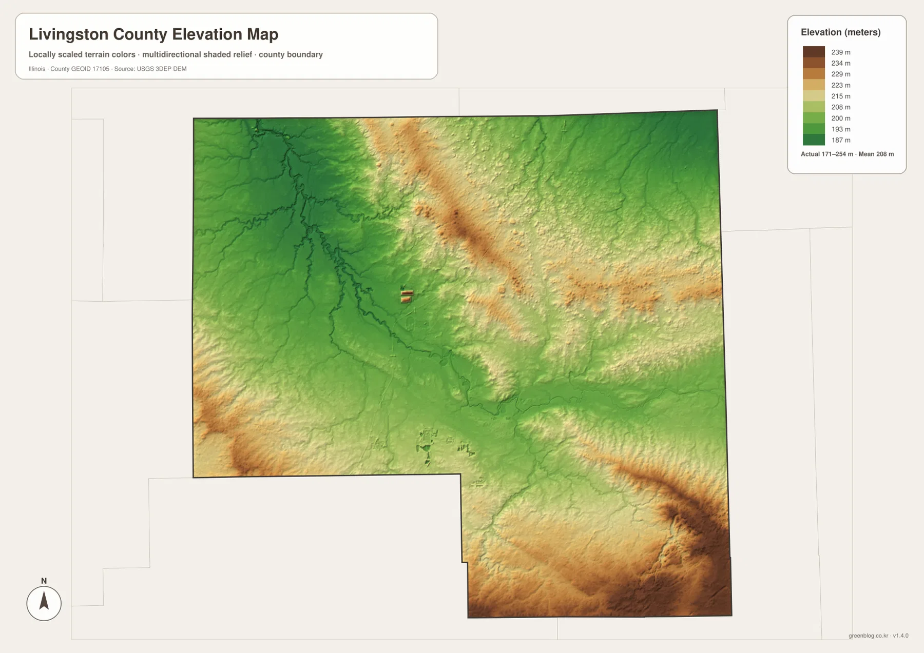
The elevation surface is generalized for county-scale comparison. It should not be treated as a survey, engineering measurement, or exact parcel elevation. For those uses, site-specific authoritative data is necessary. Here, the map is most useful beside the water map because the two together show how lower channels and surrounding uplands fit into the county’s overall terrain.
Choosing the map that matches the question
Start with the general county map when you need Pontiac, county boundaries, road numbers, and nearby communities in one view. Use the city map when the main question is where the six largest mapped communities sit relative to one another. The terrain and water map is better for Vermilion River branches and named creeks, while the elevation map is the clearest choice for comparing low drainage corridors with higher ground.
Using two maps side by side often gives the best result. A road route that seems arbitrary on the general map may make more sense once you see the stream network, and a low green strip on the elevation map becomes easier to understand after finding the same watercourse on the terrain map. For printing, reports, or close viewing, the downloadable ZIP contains the high-resolution JPG versions of the same four maps shown here as WebP previews.
Frequently Asked Questions
Which map is best for comparing Pontiac, Dwight, and Fairbury?
The city map is the quickest choice because it shows the six ranked communities without the full road detail. Pontiac is near the center, Dwight is in the northeast, and Fairbury is near the southern edge. If you also need the roads that connect their parts of the county, use the general map alongside it.
What creates the lower areas through central and southern Livingston County?
The water map shows the Vermilion River system and many tributaries cutting through those areas, while the elevation map displays many of the same corridors in lower green tones. The North Fork and South Fork Vermilion River are especially useful landmarks when comparing water and relief. Higher ground becomes more noticeable in the northeast and at the southeastern end of the county.
What is included in the downloadable ZIP?
The ZIP contains four high-resolution JPG files: the county boundary and road map, the city map, the terrain and water map, and the elevation map. Each image is 3638 × 2572 pixels. The water and elevation maps are county-scale reference products, so they should not replace flood studies, legal boundary records, surveys, or engineering-grade elevation data.
Map File Information
Download the Livingston County boundary and road map, city map, terrain and water map, and elevation map together as high-resolution JPG files.
- Printable Size: 3638 × 2572 px each
Related Maps
Sources and references
- U.S. Census Bureau TIGER/Line Shapefiles – county boundary and geographic reference
- USGS National Hydrography – rivers, creeks, and hydrography reference
- USGS 3D Elevation Program – elevation and terrain reference
- Illinois State Archives – Livingston County – county establishment and administrative history
- City of Pontiac Community Information – local context for the county seat
Green Map creates custom-edited map images using open geographic data sources such as geoBoundaries, Natural Earth, OpenStreetMap, and government open data.
These maps are edited visual materials, not raw data files, and are provided for education, documents, presentations, and graphic reference.