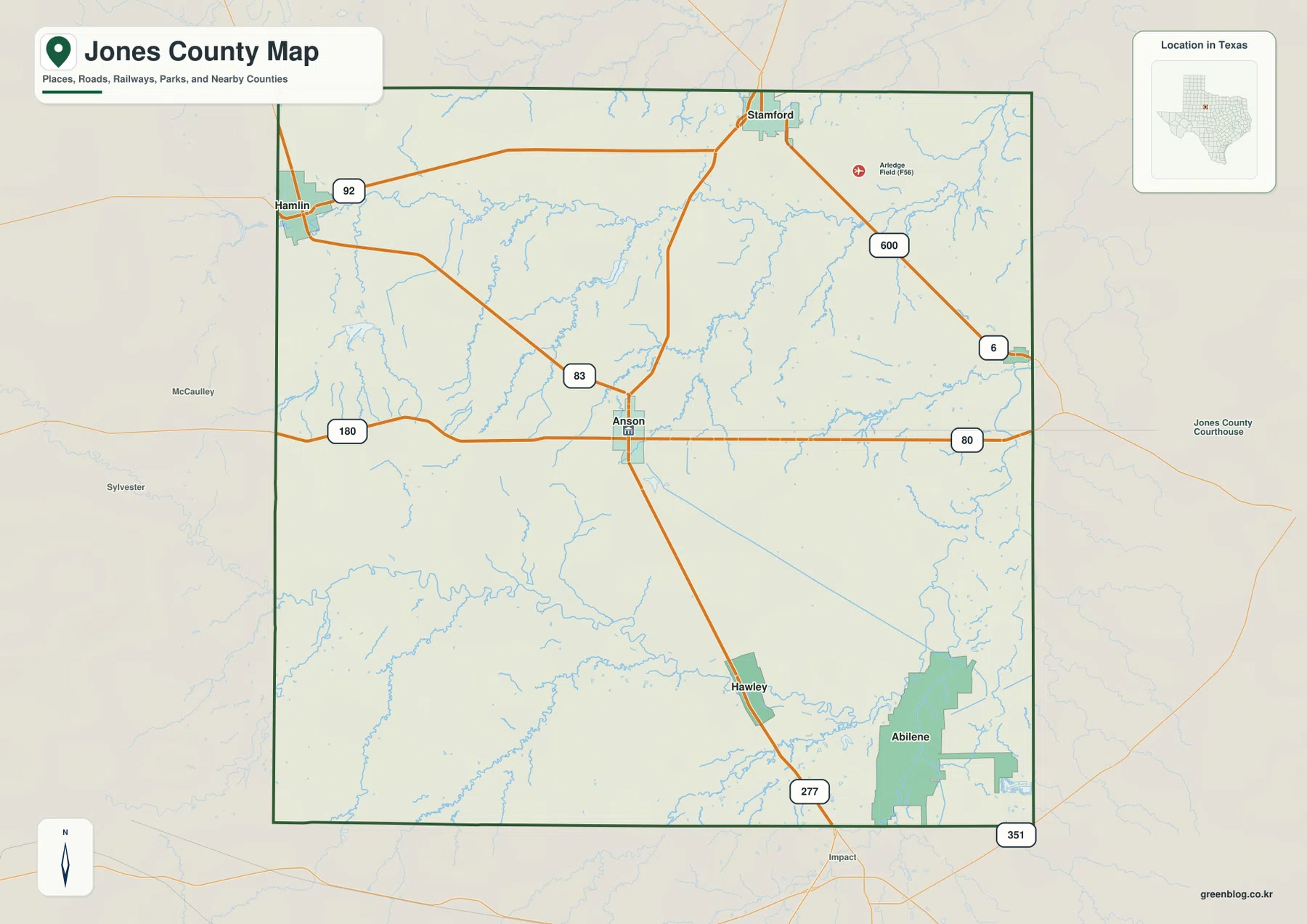
Jones County, Texas is centered on Anson, with Hamlin near the northwest edge, Hawley to the south, and Lueders near the eastern boundary. The map package on this page separates four kinds of information that are easy to confuse on a single crowded image: roads and communities, direct city connections from Anson, named water features, and elevation. The general map is useful for finding U.S. 180, U.S. 83, U.S. 277, and nearby towns. The water map highlights the Clear Fork Brazos River and smaller creeks and lakes, while the elevation map shows a mapped range of about 450 to 603 meters. High-resolution JPG copies of the maps are available together in the download ZIP below.
The county makes more sense when Anson is used as the starting point rather than treating every labeled place as equally central. U.S. 180 runs east-west through Anson, U.S. 83 approaches from the northwest, and U.S. 277 continues south toward Hawley and the Abilene side of the map. Hamlin is tied to the northwest road network, Stamford appears at the northern edge, and Lueders sits near the east. South of those communities, the Clear Fork Brazos River crosses the county in a broad, winding course. Elevation colors add another distinction: higher ground is concentrated in the west and southwest, while lower green tones become more common toward the east.
Table of Contents
Start at Anson where U.S. 180, U.S. 83, and the southbound route meet
Anson is the county seat and the clearest central reference on the general county map. U.S. 180 crosses the city from west to east, while U.S. 83 comes in from the northwest before meeting the Anson road network. U.S. 277 leaves the central area toward Hawley and continues toward Abilene. Finding these three routes first makes it much easier to orient the rest of the county, because the western boundary, the Stamford direction to the north, and the eastern side can all be compared from the same central point.
The northwest corner is organized around Hamlin and Highway 92, with U.S. 83 running back toward Anson. Stamford is shown along the northern boundary, and FM 600 angles southeast from that area. Near the east side, Highway 6 and U.S. 80 connect toward places outside the county. At the lower right, part of the Abilene urban area and Highway 351 appear close to the map boundary. Those labels are useful because they show that Jones County is not an isolated road grid: several of its most visible routes continue directly toward larger neighboring areas.
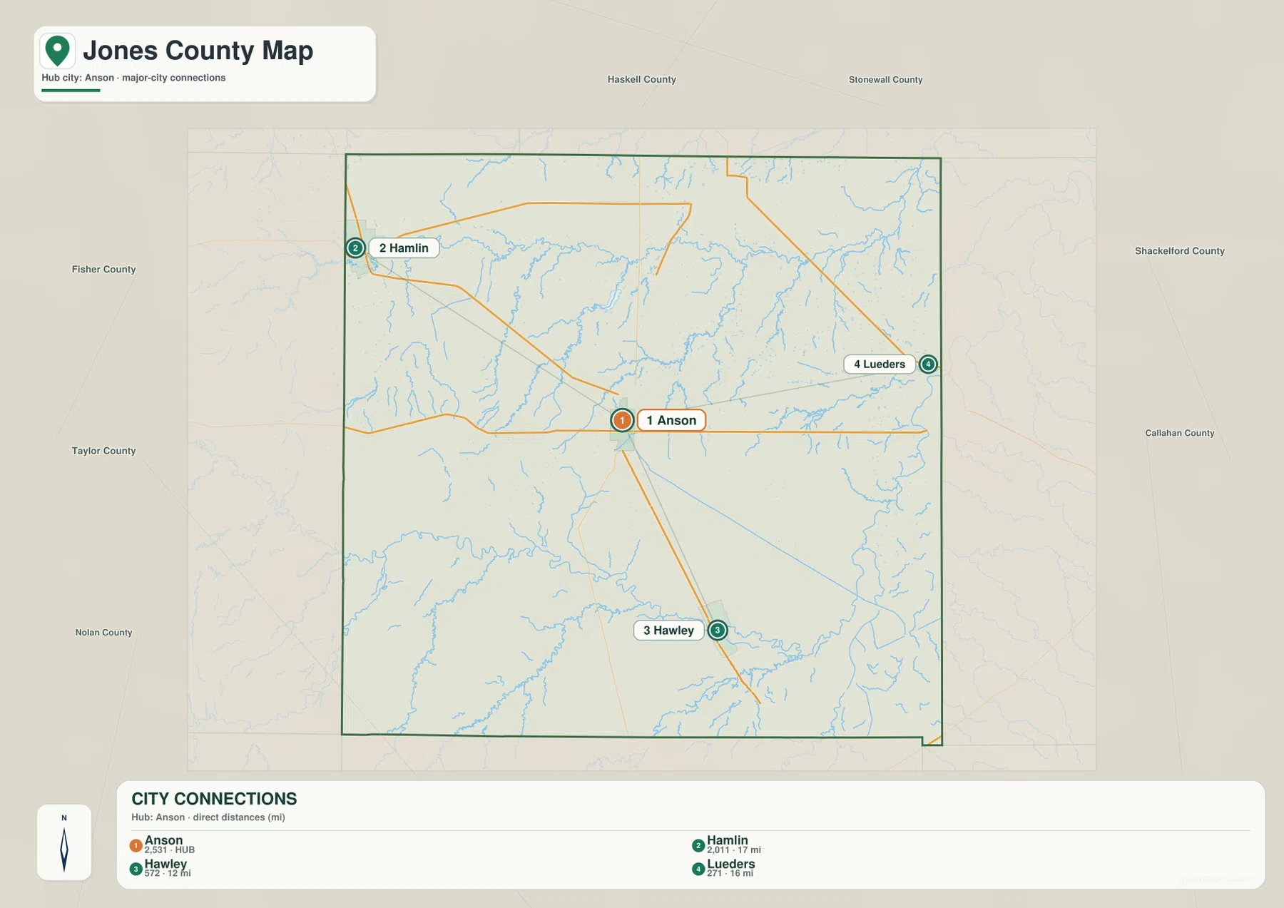
Anson’s city-connection map spreads in three different directions
The city-connection map removes much of the road detail and focuses on four places. Anson is marked as the hub with a value of 2,531. Hamlin is listed at 2,011 and about 17 miles from Anson, Hawley at 572 and about 12 miles, and Lueders at 271 and about 16 miles. The distances printed on the map are direct-distance references, so they should not be read as exact driving mileage. Their value is in showing the relative spacing of the communities without the distraction of every local road.
The directions are just as important as the numbers. Hamlin lies near the northwest edge, Hawley is almost due south of Anson, and Lueders is close to the eastern boundary. Together they form a wide spread around the hub rather than one continuous urban corridor. The surrounding county names make that distribution easier to place: Fisher County is to the west, Haskell and Stonewall counties are to the north, Shackelford and Callahan counties are to the east, Taylor County is to the south, and Nolan County is southwest. Hawley’s position is especially useful for understanding the connection toward Taylor County and Abilene.
Clear Fork Brazos River defines the south while smaller lakes and creeks fill the north
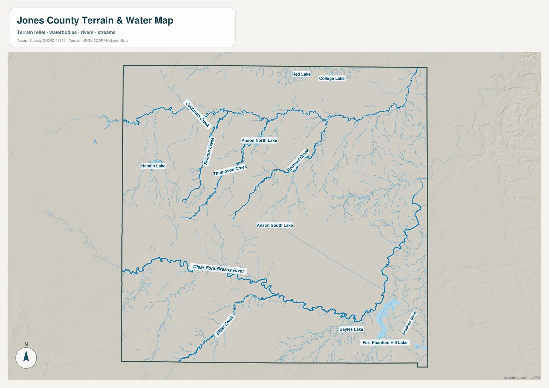
The most prominent named water feature on the terrain-and-water map is the Clear Fork Brazos River. It enters the southern part of the county from the west and follows a long, curved course toward the east. Because the river is drawn with a heavier blue line than the smaller tributaries, it becomes an immediate reference for the lower half of Jones County. Bitter Creek is labeled south of the river in the southwest, while Sayles Lake and Fort Phantom Hill Lake appear near the southeastern side of the map.
The northern and central sections contain a different mix of water features. Hamlin Lake is labeled in the northwest. Red Lake and College Lake appear near the north, and Anson North Lake and Anson South Lake provide clear references around the county seat. California Creek and Thompson Creek are among the named streams in the western and central area. Numerous thinner tributaries become more visible toward the east, where the drainage network is denser than it looks on the general road map.
This layer is best used for location rather than current water conditions. A blue line or lake label does not tell you the present flow, flood stage, or whether a road crossing is passable. For a classroom or reference map, however, the named features make useful comparisons. Anson’s two labeled lakes can be placed beside the city map, while the Clear Fork Brazos River can be compared with Hawley and the southern highway corridor to see how roads, settlements, and drainage occupy different parts of the county.
Elevation falls from the western high ground toward the eastern side
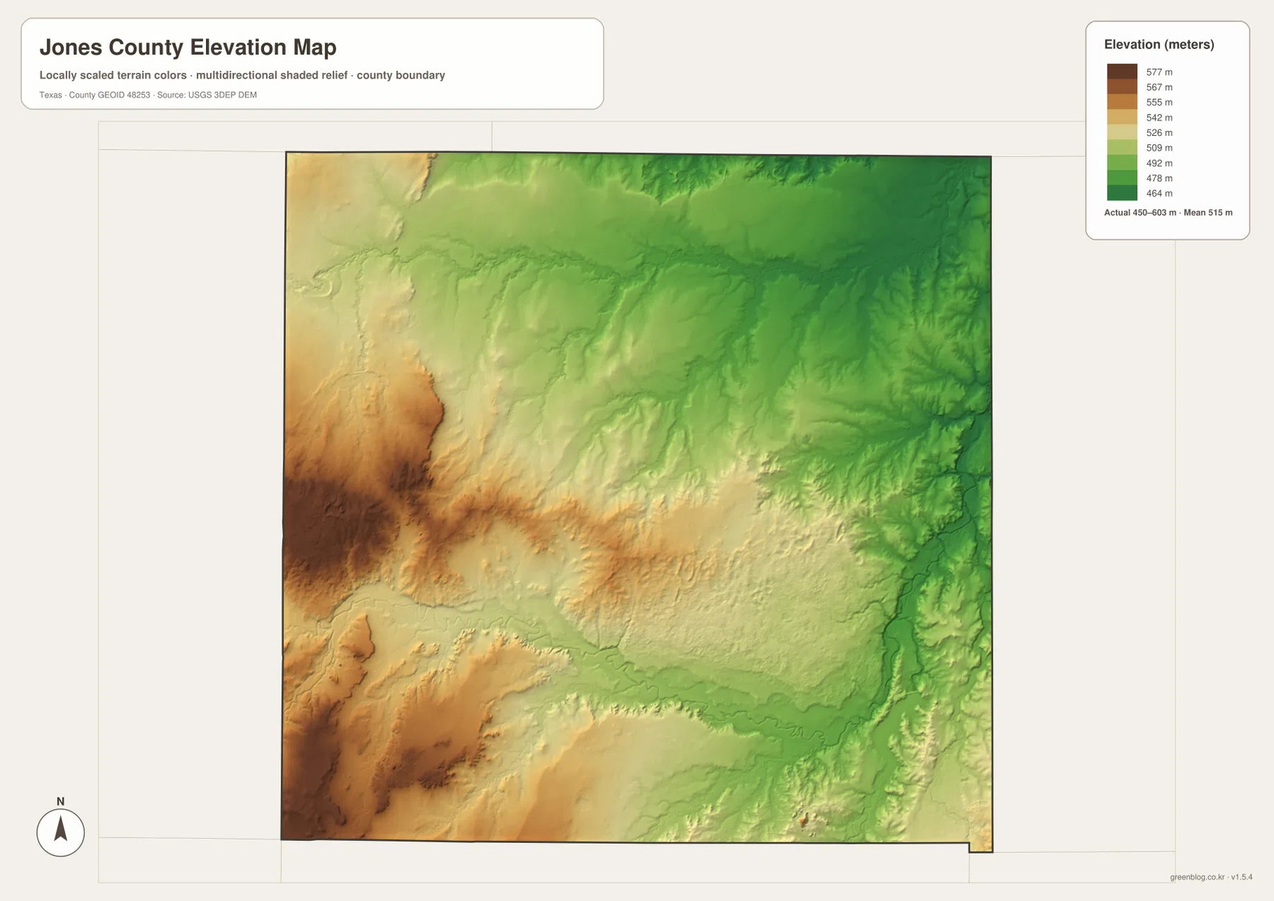
The supplied elevation map gives an actual mapped range of about 450 to 603 meters, with a mean near 515 meters. Brown and dark tan colors are concentrated in the west and southwest, where the shaded relief shows more pronounced ridges and incised valleys. Across the center, the colors shift through yellow and light green. The east and northeast contain a broader area of darker green, indicating lower elevations. The county therefore has a clear west-to-east change even though the general road map can make the landscape look relatively uniform.
The southern Clear Fork Brazos corridor is also visible as a lower band cutting across the terrain. When the elevation and water maps are compared, the river’s broad course lines up with a lower part of the landscape, while higher brown terrain rises farther west and southwest. Anson sits closer to the middle elevation range, which makes it a useful point for comparing the higher Hamlin direction with the lower eastern side near Lueders. This map is especially helpful when a reader wants to see relief rather than just city names and highway numbers.
Comparing roads, water, and relief explains the county better than any single layer
Anson is a good example of how the maps complement one another. On the county map it is the road junction for U.S. 180, U.S. 83, and the route south toward U.S. 277. On the city map it is the hub for Hamlin, Hawley, and Lueders. The water map places Anson North Lake and Anson South Lake nearby, while the elevation map puts the city between the higher western terrain and lower eastern terrain. Looking for the same place on each map turns four separate images into one coherent picture of central Jones County.
Hamlin and Hawley illustrate two other parts of the county. Hamlin lies close to the northwestern high ground and Hamlin Lake, with Highway 92 and U.S. 83 providing the most visible road references. Hawley sits south of Anson along U.S. 277 and is much closer to the southern river corridor and the Abilene side of the map. Lueders, on the other hand, is an eastern reference point where lower elevation colors and a denser network of small drainage lines become more noticeable. These contrasts are specific to the supplied Jones County maps and are more informative than a generic rural-versus-urban description.
Neighboring counties help orient the roads that leave Jones County
The Jones County outline is close to rectangular, although the southeastern edge includes a small stepped indentation. The city map labels the neighboring counties around it: Fisher to the west; Haskell and Stonewall to the north; Shackelford and Callahan to the east; Taylor to the south; and Nolan to the southwest. These labels are useful whenever a highway approaches the boundary, because the road’s direction can be tied to a named neighboring county rather than a vague edge of the map.
Several communities sit close enough to the perimeter to reinforce those directions. Stamford is shown at the northern boundary, Hamlin is near the west, and Lueders is close to the east. The Abilene urban area appears just beyond the southeast side of the county map. This is why the county is easiest to understand as a central Anson hub with outward connections rather than as a single compact city region.
Use each map for the detail it shows most clearly
Choose the general county map when you need roads, city locations, the county boundary, and nearby places in one view. The city-connection map is better for a clean comparison of Anson, Hamlin, Hawley, and Lueders, especially when the printed distance references matter. The terrain-and-water map is the best choice for the Clear Fork Brazos River, labeled creeks, and small lakes. The elevation map is the clearest way to show the higher western ground, lower eastern terrain, and the lower river corridor across the south.
The download archive contains high-resolution JPG copies of the county map, city map, terrain-and-water map, and elevation map. These files are more suitable than browser screenshots when labels need to remain readable or when the maps are prepared for A3 printing. Download the ZIP below and select the individual JPG that matches the information you need.
Frequently Asked Questions
Which mapped city is closest to Anson on the city-connection map?
Hawley is shown about 12 miles from Anson, making it the closest of the three connected cities. Lueders is about 16 miles away and Hamlin about 17 miles. These are straight-line reference distances, not driving mileage.
What is the most prominent river on the Jones County water map?
The Clear Fork Brazos River is the largest and most visually prominent named waterway, winding across the southern part of the county. Smaller lakes and creeks are labeled farther north and around Anson.
Which side of Jones County is higher on the elevation map?
The west and southwest are generally higher, while lower elevations become more common toward the east. The supplied elevation map shows a range of about 450 to 603 meters and a mean near 515 meters.
Sources and Reference Data
For official source layers and additional checking, see the U.S. Census Bureau TIGER/Line Shapefiles for boundaries and roads, USGS National Hydrography for named water features, and the USGS 3D Elevation Program for elevation data.
Map File Information
The archive includes high-resolution A3 JPG files for the Jones County map, city-connection map, terrain-and-water map, and elevation map.
- File Type: JPG
Related Maps
- Shackelford County Texas map
- Stonewall County Texas map
- Taylor County Texas map
- Scurry County Texas map
- Throckmorton County Texas map
Green Map creates custom-edited map images using open geographic data sources such as geoBoundaries, Natural Earth, OpenStreetMap, and government open data.
These maps are edited visual materials, not raw data files, and are provided for education, documents, presentations, and graphic reference.