Wakulla County Map files on this page can be previewed in the article and downloaded as high-resolution A3 JPG images in one ZIP archive. The county is easiest to understand by starting inland at Crawfordville, then following separate road-and-water directions toward Sopchoppy in the southwest, St. Marks in the southeast, and Panacea on the central Gulf side. The short distance from Tallahassee to the county’s northern edge can make Wakulla seem suburban at first glance, but the maps show a much larger landscape of forest, rivers, estuaries, and tidal marsh.
The county reference map combines Crawfordville, Sopchoppy, St. Marks, Panacea, nearby county lines, and major road labels such as US 319 and US 98. The ranked city map narrows the view to Sopchoppy and St. Marks, which are the two incorporated cities displayed. The terrain-and-water map replaces most urban emphasis with the Sopchoppy River system, St. Marks River, Ochlockonee River, bays, creeks, and Gulf shoreline. Together, those views make the inland administrative center, the two small municipalities, and the wet coastal landscape much easier to separate.
Table of Contents
Crawfordville is the inland reference for the Tallahassee side
Crawfordville is the clearest place to begin reading the county map. The Wakulla County Courthouse is marked there, and US 319 runs north toward Leon County and the Tallahassee direction. Woodville appears just beyond the northern county line, reinforcing how close Crawfordville’s road network is to the state-capital side of the region even though the Gulf coast occupies much of southern Wakulla County.
Roads east of Crawfordville are labeled with routes including 267 and 61, while the main network south eventually meets US 98 and the roads leading toward St. Marks, Sopchoppy, and Panacea. Existing county material also notes that no Interstate highway crosses Wakulla County. That makes the US highways and state-road connectors especially important: the county is not organized around one freeway, but around several routes that fan out from the inland settlement area toward separate river and coastal destinations.
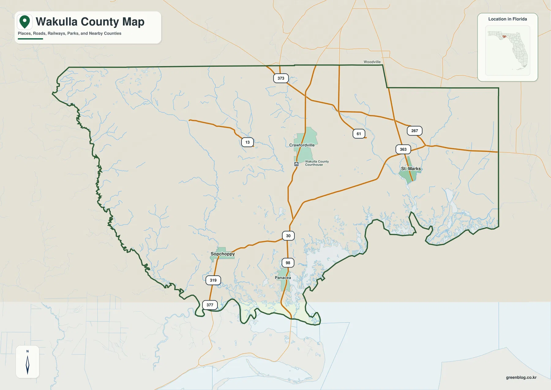
The outer boundary adds another layer of context. Leon County is to the north, Jefferson County to the east, Liberty County to the west, and Franklin County lies toward the southwest. The western line bends through low river country, while the southern edge is broken by bays, marsh, and tidal channels. This is why places that look close along the coast are not necessarily connected by a short coast-parallel road.
The city map shows Sopchoppy and St. Marks, not Crawfordville
The ranked city map is intentionally simple. Sopchoppy appears as the first-ranked city and St. Marks as the second, with the two markers placed far apart in the southwest and southeast. Crawfordville is absent from that ranking even though it is the county seat and the most prominent inland settlement on the general map. The difference comes from the map layer being used: the county reference map is for major places and roads, while the city map is limited to the incorporated cities displayed in its index.
Sopchoppy and St. Marks also occupy very different physical settings. Sopchoppy is tied to the forest-and-river country of western Wakulla, while St. Marks is close to a river estuary and the Gulf marshes. The wide space between them contains Crawfordville, forest, wetlands, and smaller communities rather than a continuous belt of development. The city map therefore works well as a quick reminder that Wakulla County’s municipalities do not form one coastal urban chain.
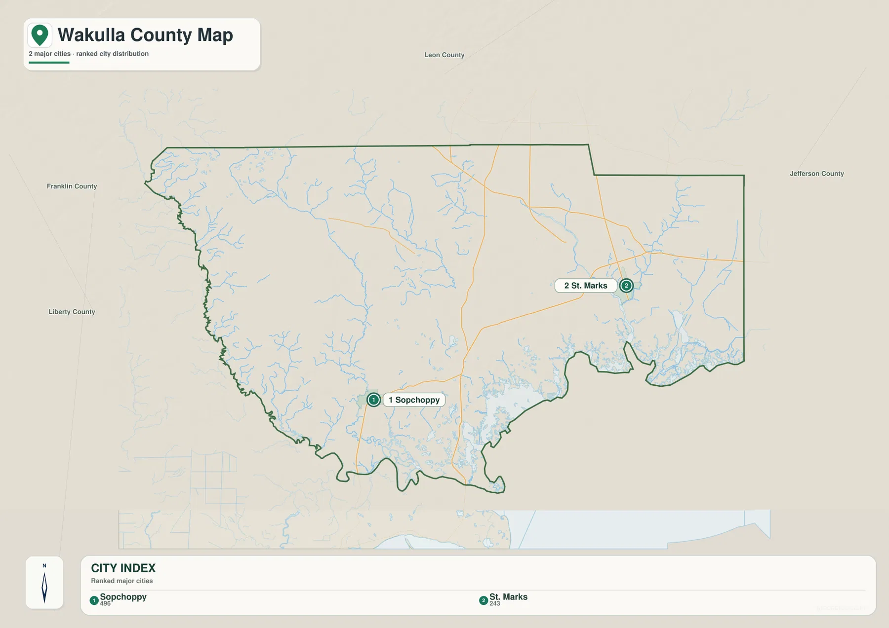
Panacea is another good example of why the two maps should be used together. It is an important coastal place on the county reference map, but it is not part of the two-city ranking shown here. A visitor looking for a community, beach access direction, or road should therefore begin with the general county map rather than assuming the city index contains every named settlement.
The Sopchoppy River system defines much of western Wakulla
On the terrain-and-water map, the western half of the county is dominated by the Sopchoppy River system. West Branch Sopchoppy River enters from the northwest and connects toward the main Sopchoppy River, while Lost Creek is labeled farther east. When the town of Sopchoppy is located first on the county map and then compared with this water view, the surrounding landscape makes more sense as a network of forested streams and wetlands rather than open agricultural plain.
The Ochlockonee River appears near the southwestern edge, and the coast includes named waters such as Dickerson Bay and Levy Bay. Tin Top Bay is visible just outside the western county boundary on the map. These features show why the southwest has a deeply indented shoreline instead of a long straight beachfront. Driving between river mouths or bays normally requires following inland roads around wet ground rather than tracing the coast directly.
At St. Marks, roads and river geography come together
The southeastern water map is organized around the St. Marks River. The river approaches the lower county from the north, while East River and Stony Bayou Pool are also labeled near the coastal wetland complex. On the county reference map, St. Marks is reached by the road network around SR 363 and the eastern routes, making it a useful transition point between inland travel and the river-estuary landscape.
Existing county material connects this lower system with the Wakulla River and Wakulla Springs farther inland. Wakulla Springs is not emphasized as a major city marker in the three supplied maps, but the official state-park and hydrology material remains important for understanding the county’s water geography. Taken together, the map and source material show that the famous inland spring, the river system, and the St. Marks estuary are parts of a connected southward flow rather than unrelated attractions.
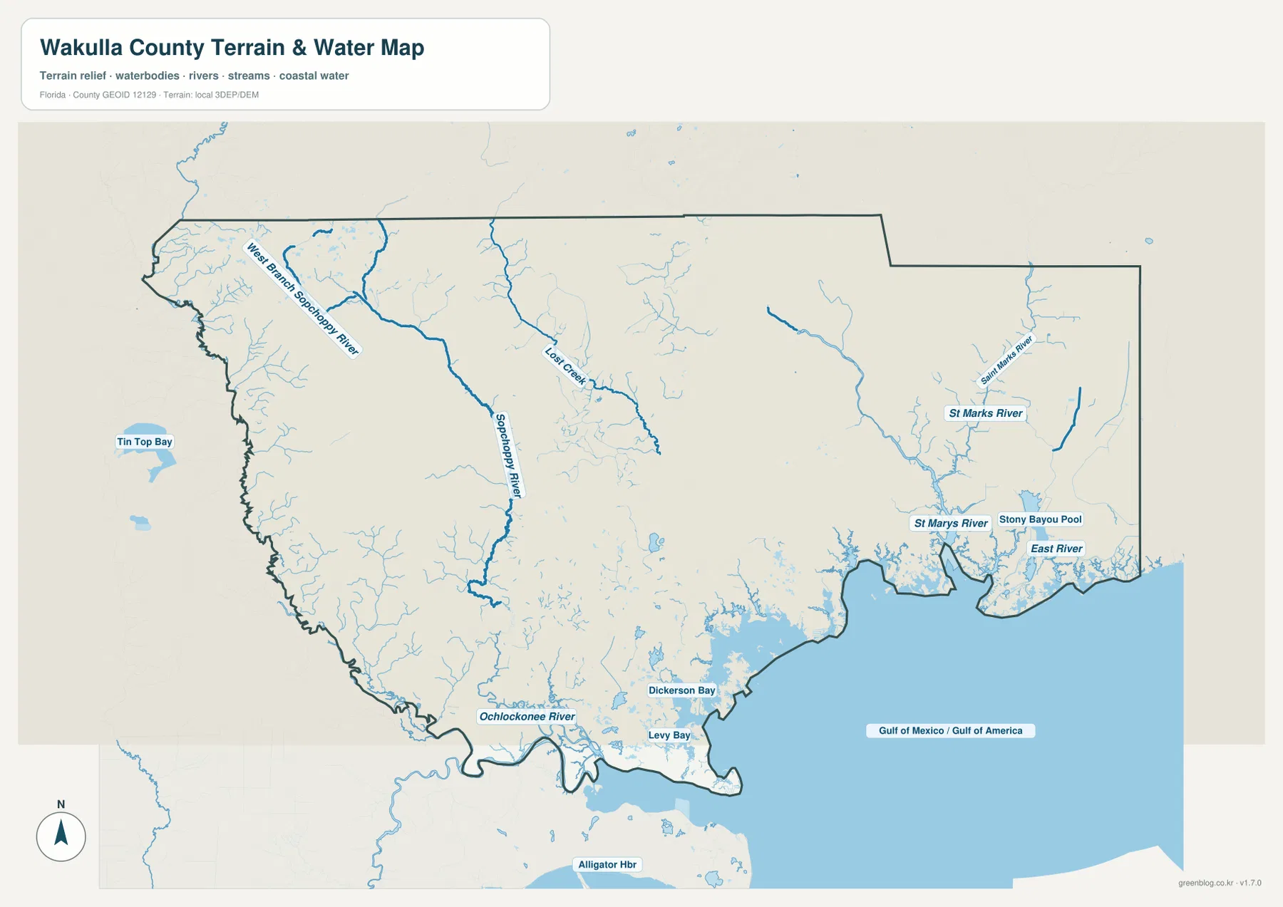
The broad southern shoreline should be read as a marsh-and-estuary coast rather than a continuous developed beach. Existing source material for St. Marks National Wildlife Refuge describes a long protected Gulf shoreline across this part of Florida. That protection, combined with tidal creeks and low wetland, helps explain why roads and towns sit back from much of the water and why the coastal communities remain separated from one another.
Panacea is a practical reference for the US 98 coastal side
Panacea appears near the south-central side of the county reference map, close to the US 98 corridor and the roads marked 319 and 377. It works as a useful point for understanding the coast between the Sopchoppy side and the eastern St. Marks side. The road does not simply follow every bend of the shoreline, so Panacea is better understood as an inland-facing access point to bays and marsh rather than a stop on a continuous oceanfront boulevard.
The water map reinforces that interpretation. Dickerson Bay and Levy Bay are nearby named waters, with many smaller tidal channels spread through the coastal lowland. Crawfordville, by contrast, has a much clearer road-centered pattern and fewer large coastal-water labels immediately around it. The short north-south distance between those places therefore represents a real change in landscape, not just a change in place name.
Use the map that matches the question
Use the county reference map when you need Crawfordville, Sopchoppy, St. Marks, Panacea, neighboring counties, or the major road network. Use the ranked city map when the question is specifically where the two incorporated cities shown—Sopchoppy and St. Marks—sit relative to each other. Choose the terrain-and-water map for the Sopchoppy River, St. Marks River, Ochlockonee River, East River, bays, and the wet Gulf shoreline.
For a classroom sequence, begin with Crawfordville and US 319, compare the two municipal markers, then switch to the water map to explain why western Sopchoppy and eastern St. Marks developed in such different settings. For trip orientation, the same order provides useful background, but current road closures, tides, park access, and refuge conditions should be checked separately before travel.
Frequently Asked Questions
Why does the city map omit Crawfordville even though it is the county seat?
The supplied ranked city map is limited to the incorporated cities displayed in its index, Sopchoppy and St. Marks. Crawfordville remains the county-seat reference on the general map, so the two products are using different place-selection rules rather than contradicting each other.
Can you drive directly along the coast from Sopchoppy to St. Marks?
Not as one simple coast-parallel route. Marsh, bays, and tidal waterways separate the two sides, so road travel depends on US 98 and inland connectors rather than following the shoreline in a straight line.
Which map is best for comparing the Sopchoppy and St. Marks river systems?
The terrain-and-water map is the best choice because it shows West Branch Sopchoppy River, Lost Creek, Sopchoppy River, St. Marks River, Ochlockonee River, East River, and the named coastal bays in one view.
Does an Interstate highway cross Wakulla County?
Existing county material indicates that no Interstate runs through Wakulla County. US 319 is the main northbound reference toward Tallahassee, while US 98 and state-road connections handle much of the east-west and coastal access.
Map File Information
Download the Wakulla County reference map, city map, and terrain-and-water map as high-resolution A3 JPG files.
- Included Files: County map JPG, city map JPG, terrain-and-water map JPG
- File Type: Three JPG files in one ZIP archive
Related Maps
- A Sumter County Florida Map
- Arcadia Roads and Peace River | DeSoto County Florida Map
- Baker County Florida Map
Sources and References
These public sources provide additional context for Wakulla County government, transportation, Wakulla Springs, river hydrology, and protected Gulf wetlands.
- Wakulla County official website
- Wakulla County geography and overview
- Florida Department of Transportation – Wakulla County profile
- Edward Ball Wakulla Springs State Park
- Geology and hydrology of Wakulla Springs
- U.S. Fish and Wildlife Service – St. Marks National Wildlife Refuge
Green Map creates custom-edited map images using open geographic data sources such as geoBoundaries, Natural Earth, OpenStreetMap, and government open data.
These maps are edited visual materials, not raw data files, and are provided for education, documents, presentations, and graphic reference.