Union County Florida Map files on this page focus on a compact inland county where Lake Butler is the central reference, Raiford sits to the east, and Worthington Springs lies near the southern edge. Roads such as SR 100 and SR 121 make those three municipalities easy to compare, while rivers and smaller creeks explain why the eastern and southern boundary is much less straight than the north and west sides.
You can preview a county reference map, a city-connections map, and a terrain-and-water map here, then download the same three subjects as high-resolution A3 JPG files in one ZIP archive. The road map is best for orientation, the city view compares the three incorporated municipalities, and the water map brings out Lake Butler, Swift Creek, Richard Creek, Five Mile Creek, ponds, bays, and smaller drainage features that are easy to miss on the general map.
Table of Contents
Lake Butler sits at the county’s clearest road junction
Lake Butler is the county seat and the most useful place to begin reading the reference map. SR 100 crosses the central area from west to east, while SR 121 reaches Lake Butler and continues toward other parts of the county. On the west side, SR 238 and 241 provide additional connections, and SR 16 appears on the Raiford side in the east. The result is a small but distinct road network with Lake Butler near the middle rather than a single highway corridor running through every community.
South of Lake Butler, the map also labels the Florida Department of Corrections complex, and farther south Worthington Springs sits close to the county line. Raiford is east of Lake Butler, while smaller labels such as Ellerbee appear toward the northeastern side. These locations show that Union County has only a few incorporated municipalities, but the road map still contains rural settlement points and public facilities spread between them.
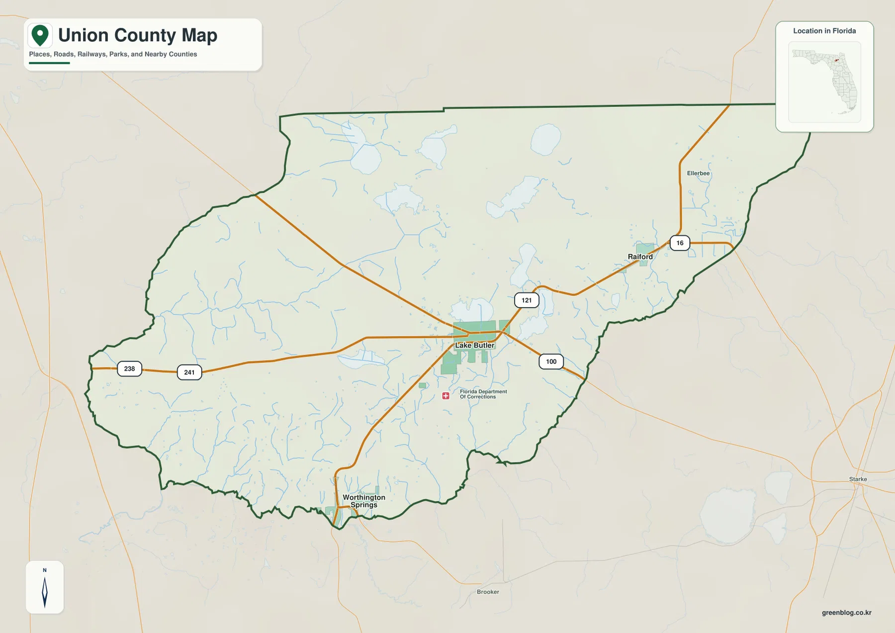
Nearby counties provide additional orientation. Bradford County is on the east, Columbia County is to the west, Alachua County is on the southwest side, and Baker County lies to the north. Starke appears outside the county to the southeast. Union County itself has no Interstate shown inside the boundary, so state roads and the river-defined county edges are more useful local references than a freeway interchange.
Raiford and Worthington Springs are both about seven miles from the hub
The city-connections map simplifies Union County to its three incorporated municipalities. Lake Butler is marked as the hub city, Raiford is numbered second to the east, and Worthington Springs is numbered third near the southern edge. The map labels both Raiford and Worthington Springs at about 7 miles from Lake Butler. Those are straight-line distances, not driving distances, so a road trip can be longer depending on the route used.
The matching distance does not mean the two towns occupy similar settings. Raiford is much closer to the eastern Bradford County side, while Worthington Springs is tied to the southern river boundary. Lake Butler therefore works as a central measuring point, but the two outer municipalities lead the reader toward different parts of the county. That contrast is more useful than treating all three places as a single small urban cluster.
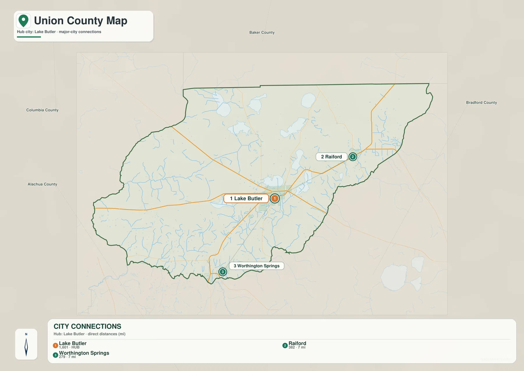
This view is also helpful because it strips away the extra road and water labels. Union County is not one continuous built-up area between the three municipal markers; forests, farms, wetlands, lakes, and small rural settlements fill much of the space. For an address or field location, first decide whether it is on the Raiford side, the Worthington Springs side, or close to Lake Butler, then return to the county map for the actual road network.
Swift Creek and small lakes form a dense interior water network
The terrain-and-water map looks very different from the road map. Palestine Lake, Granny Bay, and Center Bay appear in the northwestern interior, while Swift Creek Pond is farther north near the center. Swift Creek runs across a large part of the county, and the Lake Butler area is surrounded by additional water and wetland features. The map makes clear that water is not limited to one major river at the county edge.
East and southeast of Lake Butler, the labels include Pine Bay, Richard Millpond, Richard Creek, and Turkey Creek. Five Mile Bay and Five Mile Creek lie farther south, with Gum Branch joining the drainage network on the southeastern side. These named features are relatively small compared with a major regional river, yet together they explain why the interior has so many blue lines, ponds, and wet areas.
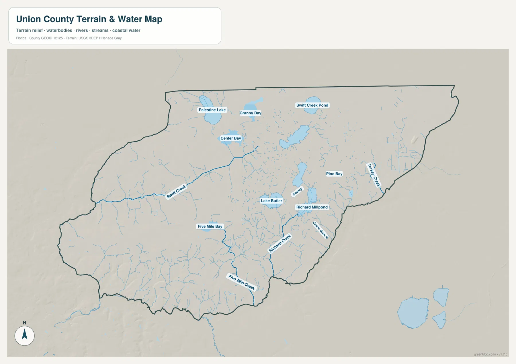
The shaded terrain is useful for broad visual context, but it is not a survey-grade or engineering elevation model. The water layer is also a location reference rather than a flood map, legal parcel map, navigation chart, or live river-stage product. If you need current flood conditions, property boundaries, or water access information, use the map to identify the place first and then consult the appropriate official source.
New River and the Santa Fe River explain the curved county edge
The existing county material describes the New River as following the Union-Bradford boundary on the eastern side before reaching the Santa Fe River near the Worthington Springs area. The Santa Fe then forms an important part of the southern and southwestern county edge. That relationship explains why the east and south sides of Union County bend with watercourses while the northern and western boundaries appear more geometric.
The rivers also have historical meaning. The county material cites Union County’s creation from Bradford County in 1921 and notes that New River and the Santa Fe River were used in the early boundary description. They are therefore more than background scenery: their courses help explain the legal outline still visible on the modern map.
Worthington Springs is a particularly useful reference for that southern geography. On the city map it is simply the third municipality, but on the broader county and river context it sits close to a complex natural boundary. Reading those layers together gives a more accurate picture than judging the town only by its small population or distance from Lake Butler.
Choose the map according to the question
Use the county reference map when you need Lake Butler, Raiford, Worthington Springs, state roads, nearby counties, or the overall boundary. Choose the city-connections map when the main question is how the three incorporated municipalities are positioned around Lake Butler. Use the terrain-and-water map for Swift Creek, Richard Creek, Five Mile Creek, Lake Butler, ponds, bays, and the smaller drainage network.
For a classroom exercise, a useful sequence is to locate Lake Butler and the state roads first, compare the two seven-mile straight-line city connections next, and then switch to the water map to see how roads and settlements sit among lakes, creeks, and wetlands. For printing or offline reference, the ZIP below contains the three map subjects as A3 JPG originals that are larger than the article previews.
Frequently Asked Questions
Are the seven-mile labels to Raiford and Worthington Springs driving distances?
No. The city-connections map uses straight-line distance from the Lake Butler hub. The road distance can be longer because vehicles must follow the available state and local roads.
Does Lake Butler refer to both a city and a lake?
Yes. Lake Butler is the county-seat city, and the terrain-and-water map also labels a lake with the same name. Their positions and map symbols distinguish the municipal label from the water feature.
Why is Worthington Springs useful for understanding the southern boundary?
Worthington Springs sits close to the southern edge, and the existing county material links that area to the meeting of the New River and Santa Fe River. That makes it a useful reference when explaining why the southern county line curves with the waterways.
Is there an Interstate highway inside Union County?
No Interstate is shown inside the supplied county map. SR 100, SR 121, and other state roads are the more useful local references, with Interstate connections reached in neighboring counties.
Map File Information
Download the Union County reference map, city-connections map, and terrain-and-water map as high-resolution A3 JPG files.
- Included Files: County map JPG, city-connections map JPG, terrain-and-water map JPG
- File Type: Three JPG files in one ZIP archive
Related Maps
- A Sumter County Florida Map
- Arcadia Roads and Peace River | DeSoto County Florida Map
- Baker County Florida Map
Sources and References
These public sources provide additional context for Union County population, government, roads, property information, and the New River watershed.
- U.S. Census Bureau – Union County QuickFacts
- Union County Board of County Commissioners
- Union County Property Appraiser
- Florida Department of Transportation – Union County transportation profile
- Florida Department of Environmental Protection – New River watershed report
Green Map creates custom-edited map images using open geographic data sources such as geoBoundaries, Natural Earth, OpenStreetMap, and government open data.
These maps are edited visual materials, not raw data files, and are provided for education, documents, presentations, and graphic reference.