Sumter County Florida Map readers quickly notice that the county has more than one center. The Villages spreads across the north as the largest built-up area on the map, Wildwood sits where major highways converge, and Bushnell remains the county seat farther south. Lake Panasoffkee provides an equally strong natural landmark in the west-central part of the county, while the long southeastern extension reaches into a much more rural landscape.
This page includes a county reference map, a city-ranking map, and a terrain-and-water map. Together they help separate settlement patterns from incorporated-city status and from the county’s lakes and streams. The same three maps are also available below as high-resolution A3 JPG files in one ZIP download, so you can use the WebP images for quick viewing and the larger JPGs for print, classwork, presentations, or offline reference.
Table of Contents
Wildwood is the county’s transportation hinge
The county map makes Wildwood easy to pick out because several important routes meet nearby. I-75 runs north-south through the center of Sumter County, Florida’s Turnpike reaches its northern end near Wildwood, SR 44 crosses the area east-west, and US 301 continues south toward Coleman and Bushnell. That combination gives Wildwood a transportation role that is different from Bushnell’s government role and from The Villages’ much larger residential footprint.
Moving south from Wildwood, the map places Coleman between the northern growth area and Bushnell. Bushnell lies near I-75 and US 301 and is marked with the Sumter County Courthouse, which helps explain why it remains the legal county seat even though it is not the largest place shown. Farther south and east are Webster and Center Hill, where the road network is less dense and the surrounding map appears much more rural.
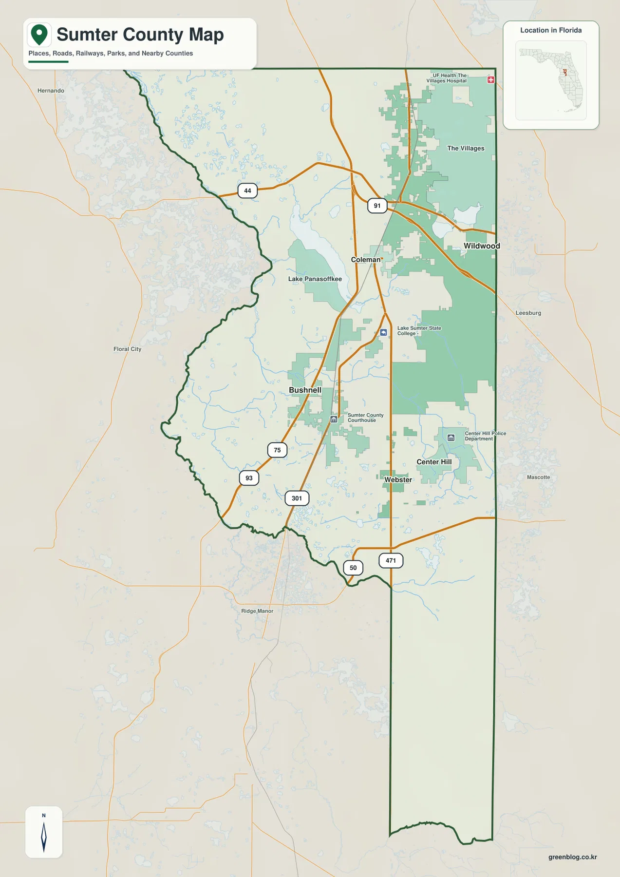
The county outline also matters. Marion County is to the north, Lake County is on the east, and the Sumter boundary narrows into a long southeastern reach toward the Polk County side. Pasco County lies to the south, with Hernando and Citrus counties to the west. Because the lower part of Sumter County extends much farther south than its main cluster of towns, a map focused only on Wildwood and Bushnell can make the county seem much smaller and more compact than it really is.
Five incorporated cities, but a much larger place in the north
The city map simplifies the county to five ranked incorporated cities. Wildwood is shown first, followed by Bushnell, Webster, Center Hill, and Coleman. Their positions form a useful north-to-south pattern: Wildwood is near the northern highway junction, Bushnell and Coleman sit in the central corridor, and Webster and Center Hill are farther into the southeastern part of the county.
The Villages is not part of that five-city ranking even though it is one of the most visually prominent places on the county map. The reason is administrative rather than geographic. The Villages is a census-designated place rather than one of Sumter County’s five incorporated cities. Looking at the two maps together prevents a common mistake: a large mapped development does not automatically represent an incorporated municipality, and the largest residential area does not automatically serve as the county seat.
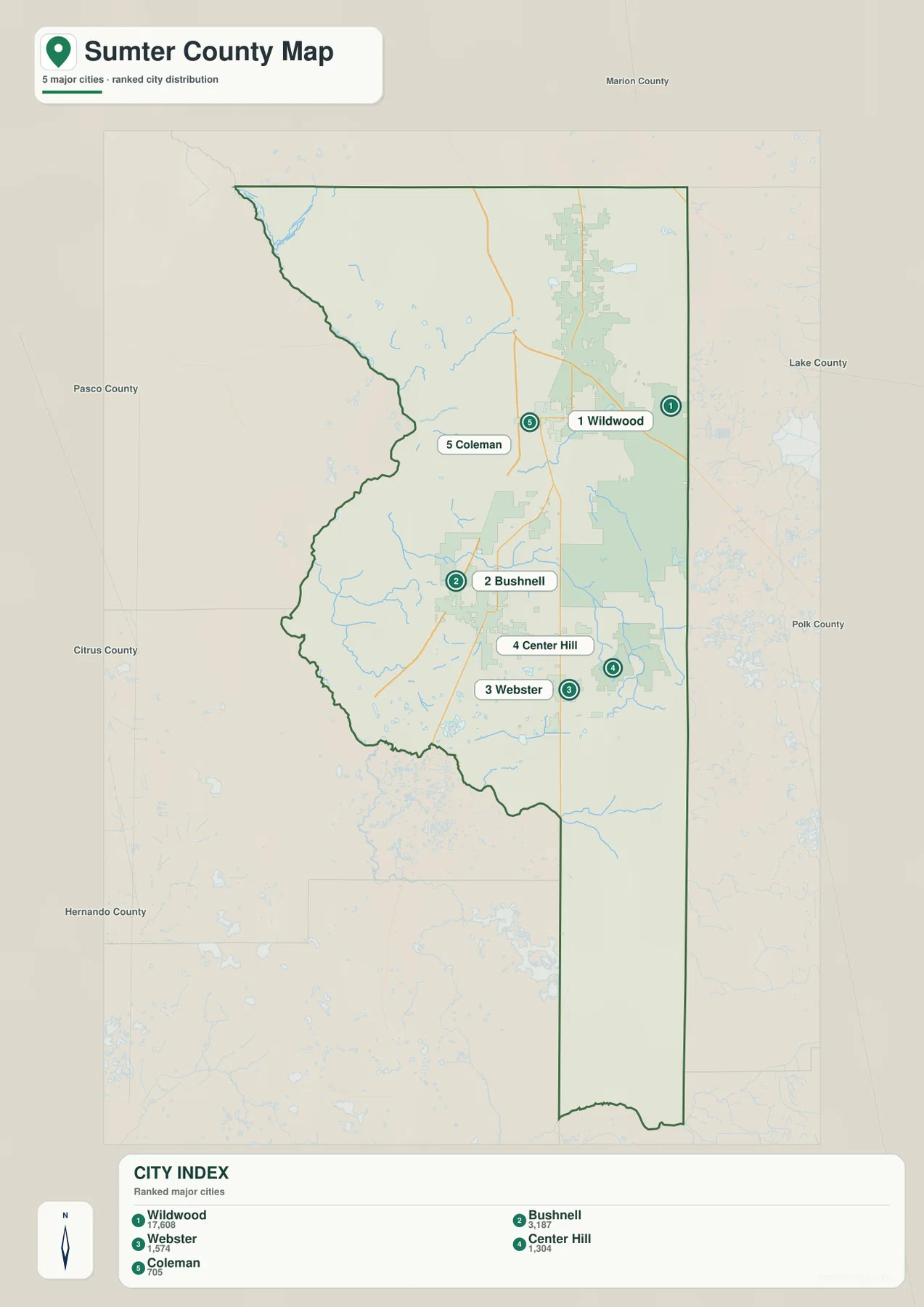
This map is especially useful when you want a cleaner view of municipal distribution without the visual weight of the larger built-up areas. It shows how the five cities are not evenly scattered across Sumter County. Instead, most of them follow the central and eastern road network, while large sections of the western and far southeastern county contain few incorporated-city labels.
Lake Panasoffkee anchors the water map
The terrain-and-water map shifts attention away from highways. Lake Panasoffkee is the dominant named lake inside the county and sits close to the irregular western boundary. Little Jones Creek appears north of the lake, while Jumper Creek, Jumper Creek Canal, Clabber Creek, and Gum Slough are labeled farther south. Near the southeastern edge, the Little Withlacoochee River crosses the boundary area, adding another clear water feature to a part of the county that otherwise has relatively few large settlement labels.
Existing county material explains that Lake Panasoffkee drains through its outlet toward the Withlacoochee River system. That relationship helps make sense of the wet, irregular western side of the county. The water map also shows many smaller ponds and lakes that are easy to miss on the road map, so it is the better choice when the question is about where water occurs rather than how to travel between towns.
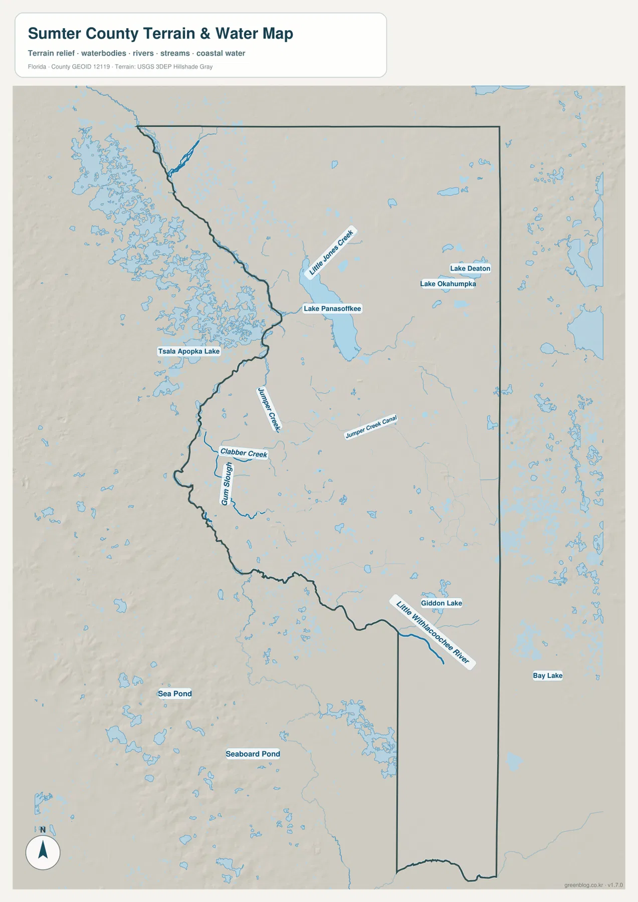
The shaded terrain background is useful for broad visual context, but it should not be treated as a survey or engineering elevation product. Likewise, the blue features identify mapped water bodies and streams; they do not show flood zones, parcel boundaries, or navigable channels. For those tasks, a dedicated official dataset is required.
The long southeast reach changes how the county should be read
One of the most distinctive features of Sumter County’s outline is the narrow section that extends south of Webster and Center Hill. Roads such as SR 471 and SR 50 help orient that area, while the terrain-and-water map shows a landscape with more scattered water and fewer major city labels. This is a sharp contrast with The Villages and Wildwood in the north, where development and major transportation routes dominate the visual pattern.
Existing county information also places parts of Withlacoochee State Forest and Green Swamp-related natural land in the southern and southeastern area. That context explains why the county can look almost like two different places on a single sheet: a rapidly developed northern section connected to major highways, and a broad rural-natural section with farms, forest, wetlands, and smaller communities. The map set works best when those two parts are considered together rather than treating the northern growth area as the whole county.
This split also explains why Sumter County has separate geographic centers for different purposes. The Villages is the most extensive built-up area, Wildwood is the key highway junction, Bushnell is the county seat, and Lake Panasoffkee is one of the strongest natural reference points. No single label tells the full story, which is why the three map types complement each other.
Which Sumter County map should you use?
Use the county reference map when you need the broadest view of place names, highways, neighboring counties, and the overall boundary. Use the city map when the main question is where the five incorporated cities sit in relation to one another. Choose the terrain-and-water map when Lake Panasoffkee, creeks, sloughs, ponds, and the Little Withlacoochee River matter more than roads.
For printing or offline work, the ZIP below contains the same three map subjects as full-size JPG files. Each image is prepared at A3 dimensions, making the download better suited to print than the smaller WebP preview images used in the article.
Frequently Asked Questions
Why is The Villages missing from the five-city ranking?
The Villages is a census-designated place, not one of Sumter County’s five incorporated cities. It appears prominently on the county map because of its large developed footprint, while the city map is limited to Wildwood, Bushnell, Webster, Center Hill, and Coleman.
Does Florida’s Turnpike continue north past Wildwood?
No. The Turnpike reaches its northern terminus near Wildwood where it connects with I-75. Northbound travel then continues on I-75, while SR 44 and US 301 provide important local connections around Wildwood and the central part of the county.
Which map is best for Lake Panasoffkee and nearby waterways?
The terrain-and-water map is the best choice because it shows Lake Panasoffkee together with Little Jones Creek, Jumper Creek, Gum Slough, and the Little Withlacoochee River. It is a location reference, however, not a flood-risk, parcel, or navigation map.
Map File Information
Download the Sumter County reference map, city map, and terrain-and-water map as high-resolution A3 JPG files.
- Included Files: County map JPG, city map JPG, terrain-and-water map JPG
- File Type: Three JPG files in one ZIP archive
Related Maps
- Arcadia Roads and Peace River | DeSoto County Florida Map
- Baker County Florida Map
- Between the Aucilla and Withlacoochee: Madison County Florida Map
Sources and References
These public sources provide additional context for Sumter County’s cities, transportation, water, and natural areas.
- Sumter County Government – Cities & Communities
- U.S. Census Bureau – Sumter County QuickFacts
- Florida Department of Transportation – I-75 Exit Numbers
- Florida Forest Service – Withlacoochee State Forest
- USGS National Hydrography
- Florida Memory – Sumter County Records
Green Map creates custom-edited map images using open geographic data sources such as geoBoundaries, Natural Earth, OpenStreetMap, and government open data.
These maps are edited visual materials, not raw data files, and are provided for education, documents, presentations, and graphic reference.