Noble County spreads from Ligonier in the west to Kendallville in the east, with Albion near the middle, Avilla in the southeast, and Rome City and Wolcottville farther north. You can download the high-resolution JPG ZIP directly from this page. The larger files are useful for reading road shields, lake names, river branches, and elevation shading. This Noble County Indiana Map page combines the U.S. 6 road corridor, a six-place city index, the Elkhart River system and northern lakes, and a 257–328 meter relief surface that rises strongly toward the east and northeast.
Albion is the most useful central reference even though Kendallville and Ligonier have larger developed areas. Indiana’s county information identifies Albion as the county seat, and State Road 8 gives it a clear east–west road position. North of Albion, U.S. 6 links Ligonier, Wawaka, and Kendallville. State Road 9 provides a north–south reference through the Rome City side. Once those two broad directions are fixed, Avilla, Wolcottville, and the southern lake-and-road network become much easier to place.
The water map adds a second layer of orientation that is especially important in Noble County. Sylvan Lake and Waldron Lake sit around the Rome City side, Tamarack Lake is farther northeast, and Bixler Lake provides an eastern landmark. The Elkhart River, North Branch Elkhart River, and South Branch Elkhart River occupy lower corridors through the west and center. Indiana DNR’s Chain O’Lakes State Park near Albion adds broader context: the park is built around nine connected kettle lakes and a glacial hill-and-valley landscape.
Table of Contents
U.S. 6 and Albion create two simple reference lines across the road map
Albion sits close to the center of the county and is crossed by State Road 8. Its developed footprint is smaller than Kendallville’s, but its position makes it an excellent bridge between the eastern and western communities. From Albion, the road network reaches east toward Avilla and north toward the lake country, while smaller local roads spread south and west into less developed parts of the county.
U.S. 6 is the clearest east–west highway in the northern half. It passes Ligonier on the west, continues through the Wawaka area, and reaches the Kendallville side in the east. Ligonier also connects with State Road 5 and nearby north–south roads, while Kendallville has a much broader urban footprint and a hospital label that makes the eastern city easy to confirm.
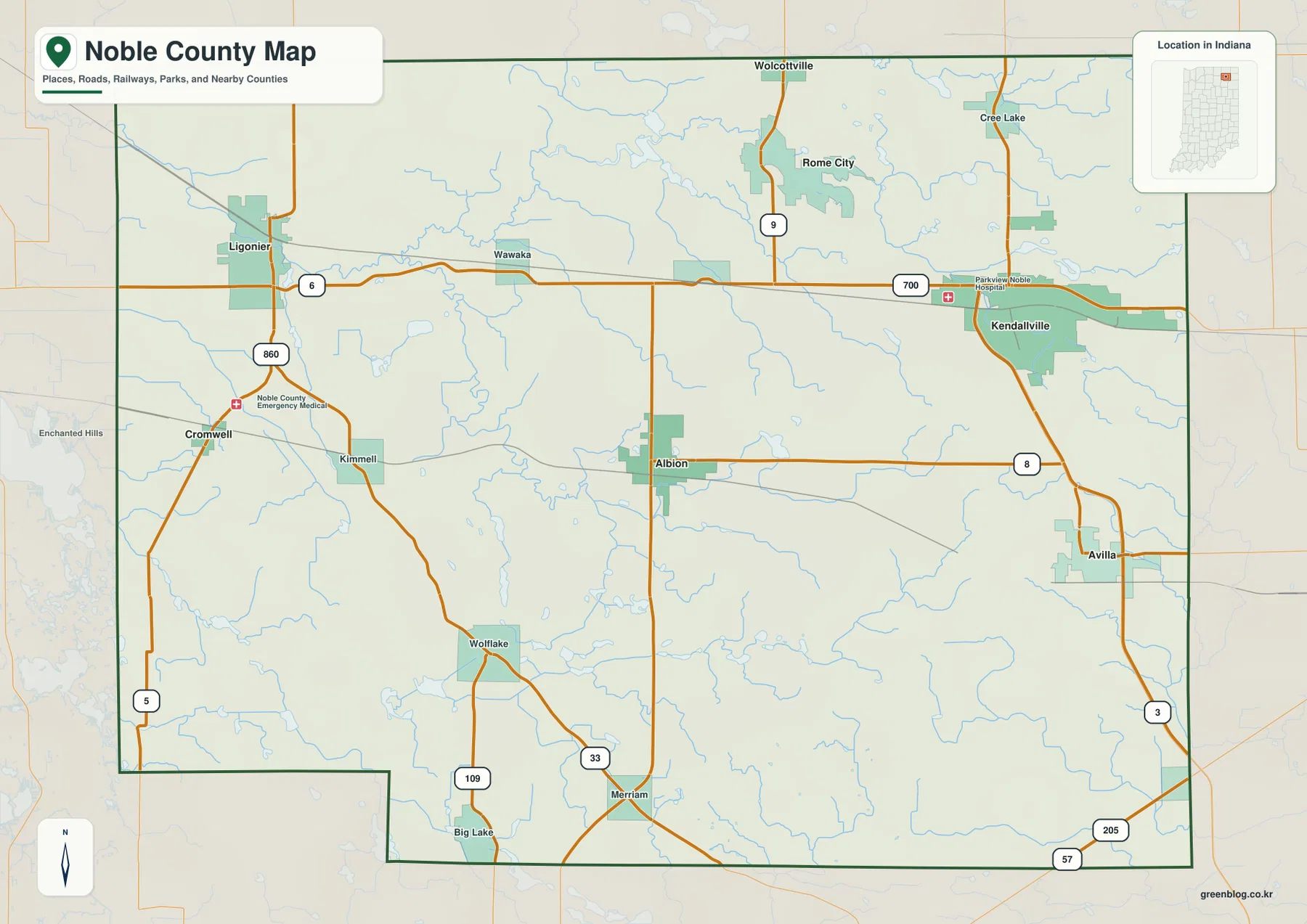
Avilla lies in the southeast near State Roads 3 and 8. Route 3 continues south along the eastern side, while Routes 205 and 57 appear closer to the southern boundary. The southwest looks different: Cromwell, Kimmell, Wolf Lake, and Merriam are smaller labels scattered around U.S. 33 and State Road 109 rather than one dominant developed center.
The northern map becomes increasingly lake-oriented. Wolcottville sits at the top edge and Rome City lies farther south along State Road 9. Roads are still important, but the repeated water bodies around Rome City mean that lakes often work better than town footprints when matching the general map to the terrain-and-water view.
Kendallville leads the six-place index, with Ligonier anchoring the west
The supplied city index highlights Kendallville, Ligonier, Avilla, Albion, Rome City, and Wolcottville. Kendallville is printed at 10,556 and Ligonier at 4,347. Avilla follows at 2,878, Albion at 2,273, Rome City at 1,182, and Wolcottville at 1,143. These figures belong to the supplied map edition rather than a live demographic feed. Their main value here is showing one large eastern center, a smaller western city, and four additional places distributed through the central, southern, and northern county.
| Rank | Place | Value printed on map | Position |
|---|---|---|---|
| 1 | Kendallville | 10,556 | East |
| 2 | Ligonier | 4,347 | West |
| 3 | Avilla | 2,878 | Southeast |
| 4 | Albion | 2,273 | Central |
| 5 | Rome City | 1,182 | North-central |
| 6 | Wolcottville | 1,143 | North |
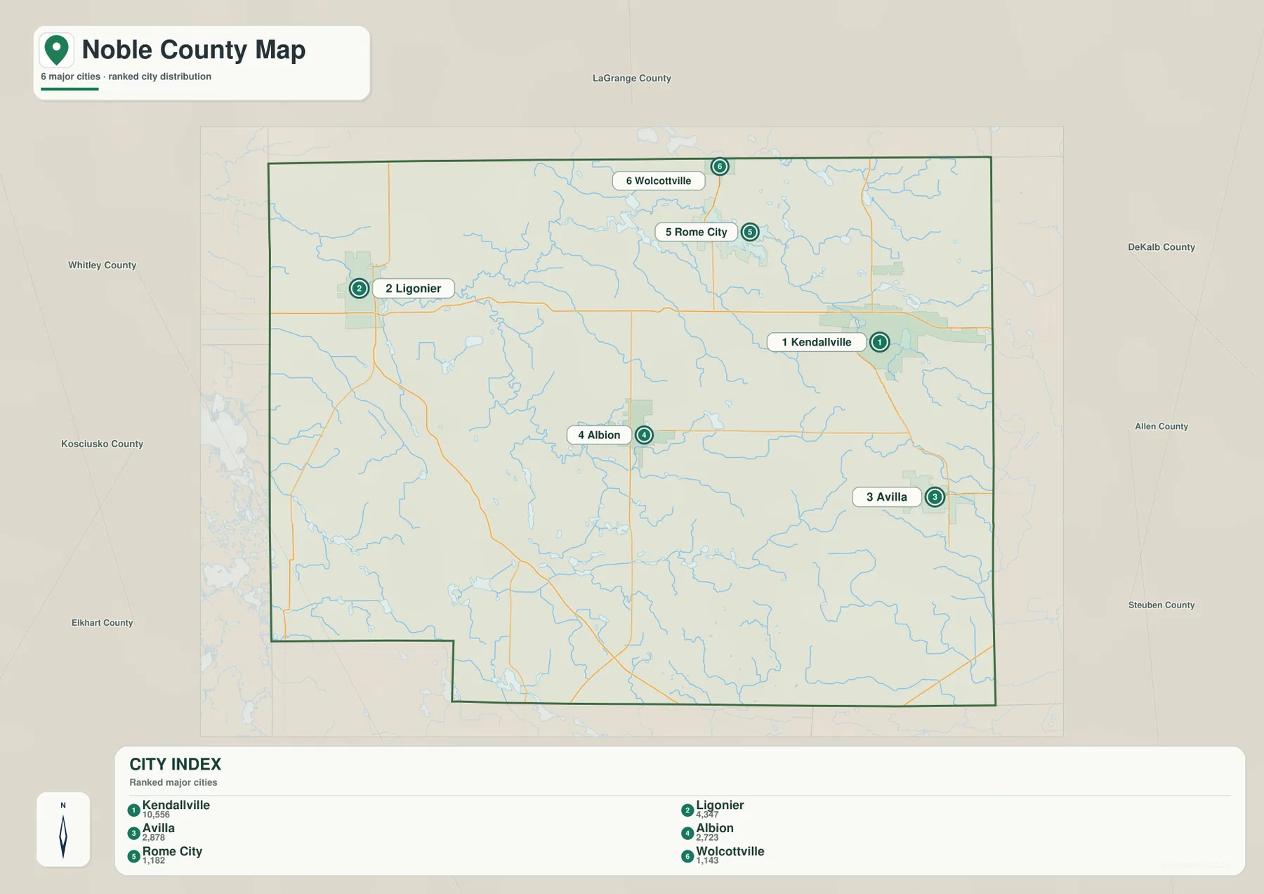
Kendallville and Ligonier share the U.S. 6 corridor but are separated by Wawaka and a substantial rural interval. Albion and Avilla lie farther south, creating another settlement band rather than extending the U.S. 6 urban line. Rome City and Wolcottville sit apart in the lake-rich north. The index therefore shows several distinct settlement groups instead of one continuous countywide city strip.
The general map adds smaller places such as Cromwell, Kimmell, Wawaka, Wolf Lake, Merriam, and Cree Lake that do not appear in the six-place index. Use the general map when those smaller names or exact road relationships matter. Use the index for a quick comparison of the six highlighted communities. For present-day population totals in Noble County, use a current official statistical source rather than treating these printed index values as live counts.
Elkhart River branches and northern lakes organize the county’s low ground
The Elkhart River system is the strongest drainage reference on the terrain-and-water map. Elkhart River enters from the west and connects with the North Branch Elkhart River, while the South Branch Elkhart River rises through the central-southern county and joins the broader system farther north. These river corridors sit within some of the lower terrain on the elevation map and help explain the broad green lowlands west of the county center.
Rome City is easy to relocate through Sylvan Lake and Waldron Lake. Tamarack Lake lies farther northeast, Bixler Lake marks the eastern side, and Skinner Lake provides a smaller central-eastern landmark. The number of separate lakes means that water features are not confined to one basin; they are spread across several parts of Noble County and often work as better orientation points than minor road labels.
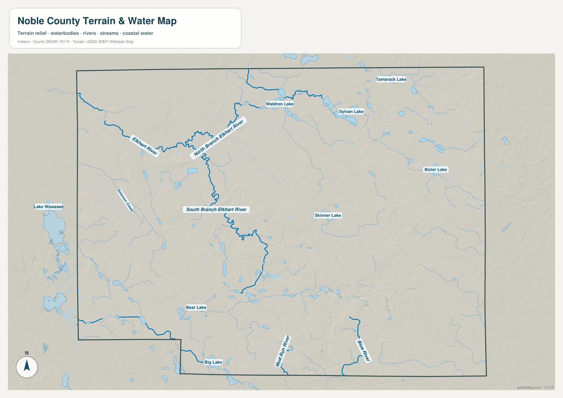
Bear Lake appears in the southwest-central portion and Big Lake lies near the southern boundary. Lake Wawasee is visible just beyond the western edge, while Solomon Creek provides another western drainage reference. The result is a county whose lowlands are divided among river branches, small lakes, and connecting channels rather than one single dominant water body.
Indiana DNR describes Chain O’Lakes State Park near Albion as a system of nine connected kettle lakes surrounded by forested glacial terrain. The supplied water map does not label every park lake separately, so the park should be treated as broader county context rather than a one-to-one match with every named lake on this image. The map is also for geographic orientation, not flood determination, navigation rights, property limits, or legal water boundaries.
The 257–328 m relief rises from western river lowlands toward the east and northeast
The supplied elevation legend gives an actual Noble County range of about 257 to 328 meters and a mean of 285 meters. Lower terrain appears in green, while yellow, tan, and brown indicate progressively higher ground. The western side around Ligonier and the Elkhart River system is broadly lower, while much of the eastern half rises into more frequent tan and brown hills.
The northwest and west-central county contain broad green surfaces interrupted by narrower stream valleys and isolated hills. Moving east from the county center, the relief becomes more varied and higher. The northeastern edge contains some of the strongest brown terrain on the map, showing a clear contrast with the lower river country around the west and center.
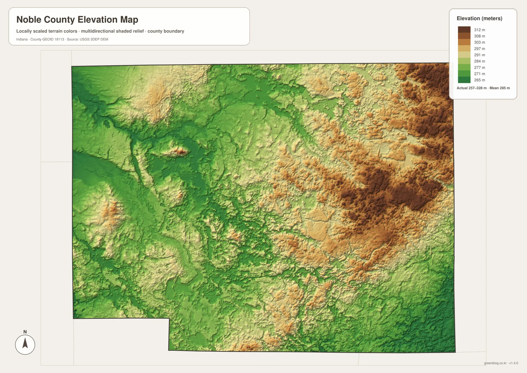
Kendallville and Avilla lie on generally higher terrain than the Ligonier side, although small creek valleys still cut green lines through the eastern uplands. The south-central and southeastern county contain a mixture of moderate hills and narrow low corridors. This makes the road network look simpler than the actual terrain beneath it, especially where local roads cross short ridges and stream-cut depressions.
Chain O’Lakes State Park’s official trail descriptions refer to glacial hills, ridges, valleys, and kettle lakes. That context fits the short, irregular relief visible around the county’s lake country. Still, this elevation image is meant for county-scale comparison. Parcel elevations, building sites, road grades, or drainage design require original USGS elevation data or measurements from a qualified survey.
Keep Albion and Kendallville fixed while matching roads to lakes, river branches, and higher eastern terrain
For settlements and roads, begin with U.S. 6 between Ligonier and Kendallville and then add Albion in the center. From there, Avilla defines the southeast and Rome City and Wolcottville define the north. U.S. 33 and State Road 109 are useful for the Cromwell–Wolf Lake–Merriam side in the southwest.
The city index is the quickest way to compare Kendallville and Ligonier with the four smaller highlighted communities. Return to the general map for Wawaka, Cromwell, Kimmell, or other minor place labels. Because the printed city values belong to the supplied map edition, a current official statistical source is the better choice for present-day population totals.
For physical geography, locate Elkhart River and its north and south branches first, then add Sylvan Lake, Waldron Lake, and Bixler Lake. Switching to the elevation image at those same positions shows the river country staying lower in the west while the eastern and northeastern county rises. That comparison connects the settlement map to the lake-and-river landscape without treating Noble County as one uniform surface.
The WebP images on this page are reduced previews. The Noble County archive contains four original 3638×2572-pixel JPG files covering the general county map, city index, terrain-and-water map, and elevation map. The larger originals are better for printing or reading small place, road, river, and lake labels.
A useful comparison is to keep Albion and Kendallville fixed as two reference points. Find Ligonier and Avilla on the general map, compare the six highlighted places on the city index, move to the water view to trace the Elkhart River branches and Sylvan Lake, and finish on the elevation image by comparing the western lowlands with the eastern hills.
Frequently Asked Questions
What is the county seat of Noble County?
Indiana’s official county information identifies Albion as the Noble County seat. On the supplied map, Albion lies close to the center along State Road 8, making it a useful reference between Kendallville and Avilla to the east and Ligonier and Cromwell to the west.
Which river and lake features are easiest to recognize?
Elkhart River and its North Branch and South Branch provide the main river framework. Sylvan Lake and Waldron Lake are strong northern references, with Tamarack Lake farther northeast and Bixler Lake in the east. Skinner, Bear, and Big lakes provide additional central and southern landmarks. The water image is for geographic orientation rather than flood or legal-boundary decisions.
Can the 257–328 m elevation range be used for exact site measurements?
No. The elevation image gives a county-wide range with a mean of 285 meters and is intended for comparing lower western river country with higher eastern and northeastern terrain. Precise property, construction, road-grade, or drainage work requires original elevation data or professional survey measurements.
Map File Information
The Noble County ZIP combines the general road-and-place map, six-place city index, terrain-and-water map, and elevation map as full-resolution JPG originals.
- File Type: ZIP containing four 3638×2572px JPG files
Related Maps
Sources and References
The article is based primarily on the supplied Noble County map set and asset manifest. The following official sources provide county, Albion, Chain O’Lakes, boundary, hydrography, and elevation context.
- Noble County, Indiana – official county information including Albion as the county seat
- Indiana DNR – Chain O’Lakes State Park – official information on the connected kettle lakes and glacial hill-and-valley landscape near Albion
- Indiana Historical Bureau – Noble County Seat – official historical context for Albion and the county courthouse
- U.S. Census Bureau TIGER/Line Shapefiles – boundary reference for Noble County and its place framework
- USGS National Hydrography – reference data for rivers, branches, lakes, and mapped water features
- USGS 3D Elevation Program – source terrain data for detailed elevation work
Green Map creates custom-edited map images using open geographic data sources such as geoBoundaries, Natural Earth, OpenStreetMap, and government open data.
These maps are edited visual materials, not raw data files, and are provided for education, documents, presentations, and graphic reference.