Use this Lee County Florida Map page to locate Fort Myers, Cape Coral, Lehigh Acres, Estero, Bonita Springs, Sanibel, and the Caloosahatchee River, and to download the matching county, city, and water maps as high-resolution A3 JPG files. The Caloosahatchee is the easiest reference point for orientation: Fort Myers sits on the south side of the river, Cape Coral spreads across the north and west, and North Fort Myers occupies the opposite bank. Farther east, Lehigh Acres and Alva form a broad inland area, while the Gulf side breaks into Pine Island, Sanibel, Fort Myers Beach, bays, and channels rather than one continuous mainland coast.
The page separates those relationships into three useful views: a county reference map with roads and place names, a city map that highlights the main incorporated communities, and a water map focused on the Caloosahatchee, coastal bays, rivers, canals, and smaller waterways. The ZIP in the Map File Information box contains the same three subjects, making it easy to compare locations on screen and then open the larger files for printing or offline reference.
Table of Contents
The Caloosahatchee as the dividing line of the central county
The county map places Fort Myers and Cape Coral near the visual center, but the river makes clear that they occupy different sides of the county’s main waterway. Fort Myers is on the southern bank of the Caloosahatchee, while Cape Coral covers a large area to the north and west. North Fort Myers lies directly across the river from Fort Myers. That simple riverbank relationship is one of the most useful ways to keep the three similarly named places straight when reading the map.
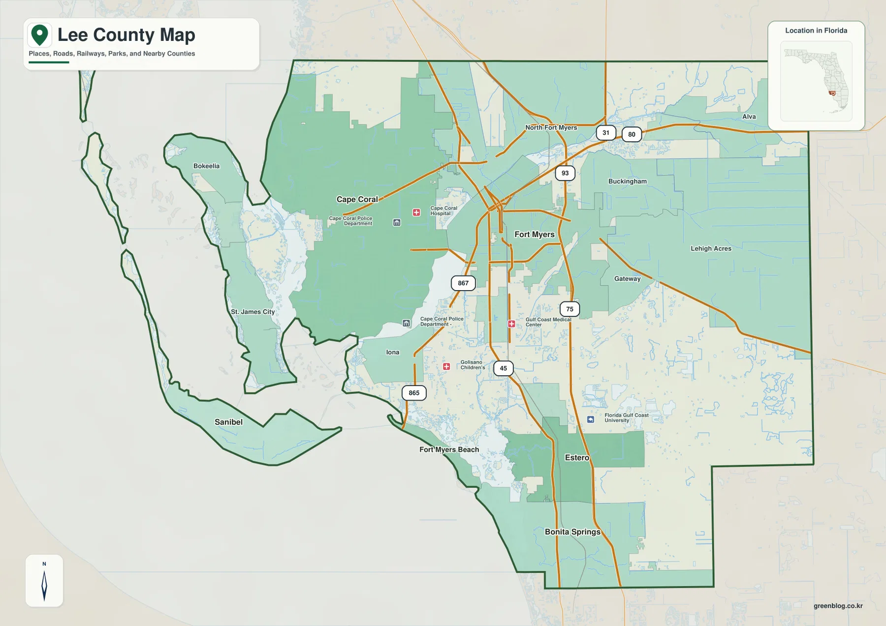
The road pattern adds another layer. I-75 runs north-south well inland from the Gulf-facing communities, while U.S. 41 passes through the more developed Fort Myers corridor before continuing toward Estero and Bonita Springs. SR 80 follows the Caloosahatchee eastward toward Alva, and SR 31 continues through the northeastern part of the county. These routes make the inland side of Lee County look more connected by long road corridors, while the western edge is broken up by islands, bays, canals, and a smaller number of access points.
Several communities shown on the county map help fill in the spaces between the major cities. Lehigh Acres covers a large inland area east of Fort Myers. Gateway lies closer to the central-southeastern road network, while Iona sits near the lower Caloosahatchee and the coastal approach. Alva appears along the river in the east. On Pine Island, Bokeelia is shown toward the north and St. James City toward the south. Seeing these names together gives a more complete picture than a map that labels only the county seat and largest municipality.
The map also helps explain the county’s unusual outline. The western boundary includes long island and shoreline segments rather than one smooth coastal edge, and the southern boundary bends around the Estero and Bonita Springs area before meeting neighboring Collier County. Charlotte County lies to the north, while Hendry and Glades counties are shown to the east and northeast on the city reference. This makes Lee County a useful example of a place where county boundaries, water, and settlement patterns need to be read together.
Where the main communities sit from Cape Coral to Bonita Springs
The city map reduces the amount of background detail and emphasizes six incorporated communities: Cape Coral, Fort Myers, Bonita Springs, Estero, Sanibel, and Fort Myers Beach. Cape Coral and Fort Myers form the central pair, although the river separates them. Estero and Bonita Springs are farther south, while Sanibel and Fort Myers Beach are positioned along the Gulf-facing island zone. The numbered city index makes it easy to compare where these communities fall within the county before returning to the more detailed road map.
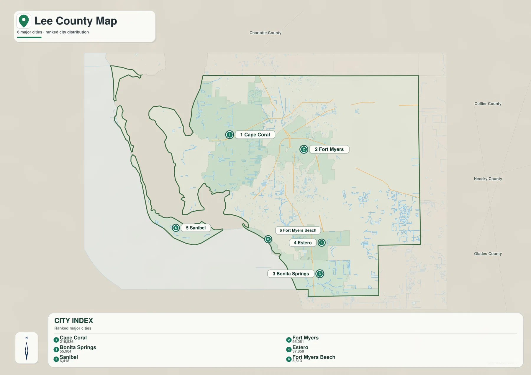
Cape Coral appears as the western member of the central urban pair and occupies a broad area shaped by an extensive canal network. Fort Myers is smaller on the map but serves as the county seat and sits at a key river crossing area. South of Fort Myers, Estero and Bonita Springs line up with the north-south transportation corridor that includes I-75 and U.S. 41. Their position is noticeably different from the barrier-island setting of Sanibel and Fort Myers Beach, even though all of these places belong to the same county.
The city map should not be treated as a complete list of settled places. Lehigh Acres, North Fort Myers, Alva, Gateway, Iona, and the Pine Island communities are visible on the broader county map but are not part of the six-place city index. For a reader trying to locate an address area or understand the full spread of development, the two maps work best together: the city view gives a quick orientation, and the county view restores the roads, unincorporated communities, and wider boundary.
From the Caloosahatchee River to the Gulf-facing bays and islands
The water map changes the emphasis completely. The Caloosahatchee River crosses the county from east to west and remains the dominant feature, with the Orange River joining from the northeast. Smaller named waterways appear farther south, including Hendry Creek, the Estero River, and the Imperial River. These streams are much easier to notice on the water-focused map than on the county road map, where streets, boundaries, and place labels compete for attention.
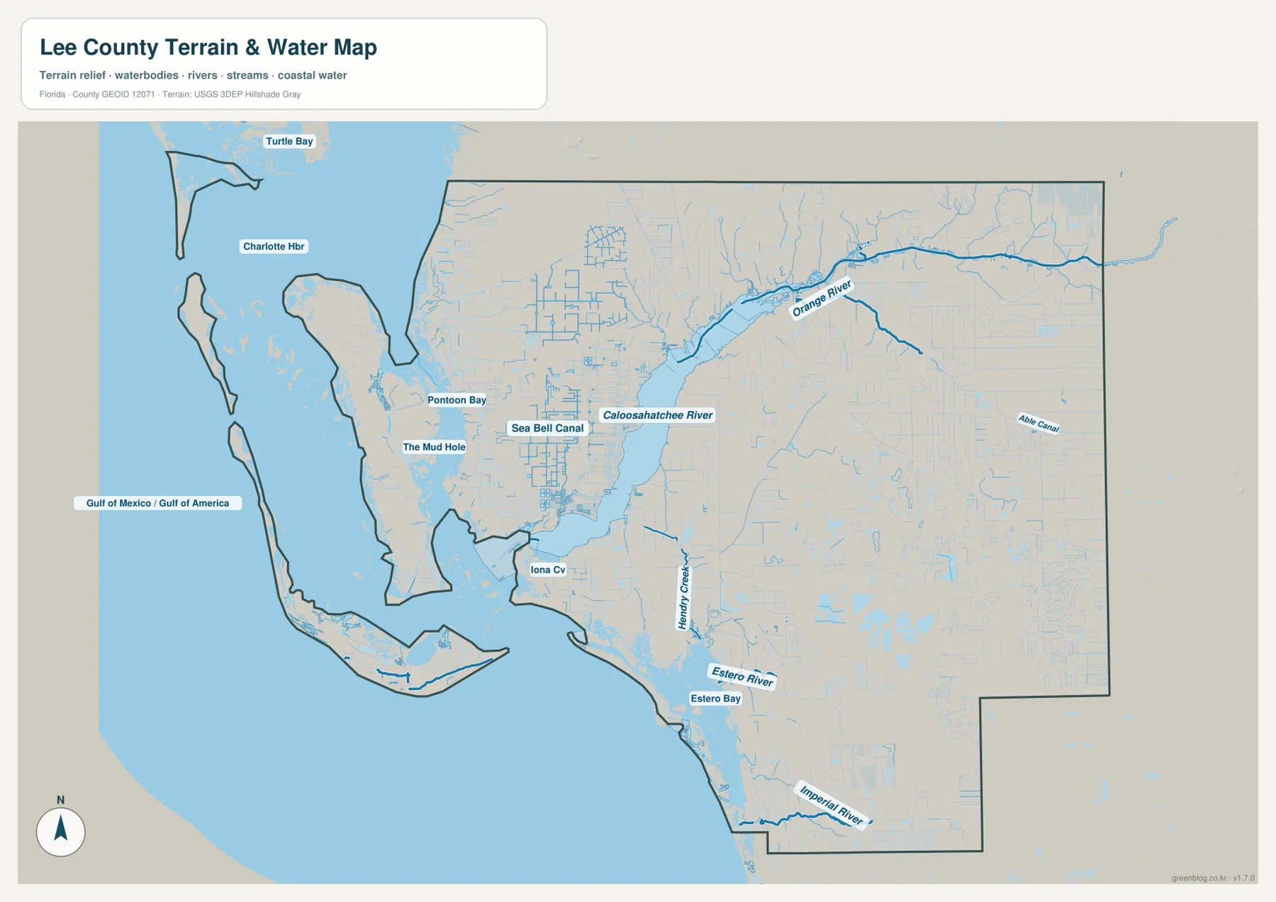
The coastal side becomes especially detailed around Pine Island, Sanibel, and Estero Bay. The map labels broad Gulf water to the west along with smaller places such as Pontoon Bay and Iona Cove, while a web of narrow channels fills the low coastal zone. The shoreline is therefore better understood as a mixture of islands, bays, passes, canals, and mainland edges. This geography helps explain why two places that look close in a straight line may depend on very different bridges or mainland approaches.
The Caloosahatchee also links the inland and coastal parts of the county rather than simply dividing Fort Myers from Cape Coral. Its lower reach opens toward the estuary and Gulf-side bays, while tributaries and canals enter from developed and rural areas on both sides. Readers who need more detail can compare the simplified map with official Caloosahatchee watershed material from the South Florida Water Management District and Estero Bay information from the Florida Department of Environmental Protection.
This water map is a geographic reference, not a flood, depth, navigation, or legal-water-boundary product. It is suitable for locating major rivers, coastal water bodies, and the relative positions of communities beside them. Current flood zones, channel conditions, bridge restrictions, or boating information can change and should be checked with the responsible agency before they are used for travel, property, or emergency decisions.
Road corridors, river crossings, and separate island gateways
One of the most practical ways to use the county map is to compare I-75 with U.S. 41. Both run generally north-south, but I-75 stays farther inland and provides the faster regional corridor toward Charlotte County to the north and Collier County to the south. U.S. 41 passes closer to established urban and commercial areas. The difference matters because a destination labeled “Fort Myers” can be much closer to one corridor than the other, especially when the destination is south or east of the historic riverfront center.
East-west movement follows a different pattern. SR 80 leaves Fort Myers and follows the Caloosahatchee toward Alva, while SR 82 serves the Lehigh Acres direction and continues southeast. SR 78 crosses the North Fort Myers and Cape Coral side before heading toward Matlacha and Pine Island. The county map also shows SR 31 in the northeastern sector and smaller state routes near the Cape Coral and Fort Myers Beach approaches. Reading these routes with the river and coastline gives more useful orientation than reading highway numbers by themselves.
Bridges and causeways become essential on the western side of the county. Cape Coral and Fort Myers depend on river crossings to connect their street networks. Pine Island is reached through the Matlacha approach, while Sanibel uses a separate causeway from the mainland southwest of Fort Myers. Fort Myers Beach occupies Estero Island and has its own access pattern. The islands may appear close together on a regional map, but their road gateways are not interchangeable.
That distinction is useful for planning even when the maps are not being used as turn-by-turn navigation. A trip from Cape Coral to Sanibel, for example, is determined by where the driver can cross the Caloosahatchee and then reach the Sanibel approach. A trip from Fort Myers to Lehigh Acres is controlled instead by inland roads and does not involve the coastal gateways. Looking at the county in terms of crossings and corridors prevents the common mistake of assuming that nearby points on opposite sides of water have a direct road connection.
Using each map for the question it answers best
The county reference map is the best starting point when you need roads, place names, county limits, and general orientation on one page. The city map is cleaner when the goal is simply to compare where the major incorporated communities are located. The water map is the better choice for tracing the Caloosahatchee, the southern rivers and creeks, and the complicated Gulf-side shoreline. Switching between these views is more useful than trying to force every detail into a single map.
The downloadable archive contains the same three map subjects as high-resolution A3 JPG files. They can be opened at a larger size for closer label reading, saved for offline reference, or printed for personal study and planning. Because the maps are general geographic references, they should not replace current official sources for parcel lines, legal boundaries, engineering measurements, emergency evacuation, real-time traffic, or marine navigation.
Frequently Asked Questions
What is the easiest way to distinguish Fort Myers from Cape Coral on the map?
Use the Caloosahatchee River first. Fort Myers is on the south side of the river, while Cape Coral occupies the broad area to the north and west. North Fort Myers is on the north bank opposite Fort Myers. That riverbank relationship makes the three names much easier to place than relying on city labels alone.
Do Sanibel and Pine Island use the same mainland road approach?
No. Sanibel is reached by its own causeway from the mainland southwest of Fort Myers, while Pine Island is approached through Matlacha. They occupy the same general Gulf-side part of Lee County, but their road connections are separate, so a route to one island does not continue directly to the other.
Which waterways stand out most on the Lee County water map?
The Caloosahatchee River is the dominant feature because it crosses the county from the eastern boundary toward the Gulf. The Orange River joins it from the northeast, while Hendry Creek, the Estero River, and the Imperial River are prominent farther south. Estero Bay and the coastal channels around the islands add another layer of detail along the western edge.
Map File Information
Download the Lee County reference, city, and water maps as original high-resolution A3 JPG files in one ZIP archive.
- Included Files: 3 A3 JPG maps
Related Maps
- Arcadia Roads and Peace River | DeSoto County Florida Map
- Baker County Florida Map
- Blountstown, SR 20, and the Apalachicola River | Calhoun County Florida Map
Sources and further reference
- Lee County Government
- Lee County Maps and GIS
- South Florida Water Management District: Caloosahatchee Watershed Plan
- Florida Department of Environmental Protection: Estero Bay Aquatic Preserve
- U.S. Census Bureau QuickFacts: Lee County
Green Map creates custom-edited map images using open geographic data sources such as geoBoundaries, Natural Earth, OpenStreetMap, and government open data.
These maps are edited visual materials, not raw data files, and are provided for education, documents, presentations, and graphic reference.