Erath County is easiest to understand by starting with Stephenville and then tracing the roads, streams, and changing terrain outward. Stephenville sits near the middle of the county’s developed road network, while Dublin is farther southwest and smaller communities such as Bluff Dale, Huckabay, and Lingleville are separated by broad rural areas. This page brings the county map, city map, water map, and elevation map together so you can compare those features without jumping between separate sources. A ZIP containing the A3 high-resolution JPG files is also available in the download box below.
The maps show a county that is not flat or uniform. The western half rises into higher, more dissected uplands, while the eastern side contains lower valleys cut by the North Bosque and Paluxy systems. Roads converge strongly around Stephenville, but the water network is much more branched than the highway network. Reading the layers together gives a practical picture of where the main communities sit, how they connect, and why some parts of the county feel more open and rugged than others.
Table of Contents
Start with Stephenville, then trace the county outward
On the county map, Stephenville lies a little south of the county’s visual center and works as the clearest orientation point. Dublin is southwest of it, Bluff Dale is near the northeastern side, Huckabay is northwest of Stephenville, and Lingleville is farther west. The spacing between these labels matters: Erath County does not have a continuous belt of dense settlement. Instead, its communities are separated by long stretches of ranch, farm, and rolling upland terrain.
The county boundary is also distinctive. Its western and southern edges include several bends rather than forming a simple rectangle, while the eastern side angles toward the southeast. Just north of the county, Interstate 20 and U.S. 80 appear as major east-west routes outside the boundary. They are useful regional references, but they should not be confused with the roads that actually organize daily movement between Stephenville, Dublin, and the smaller communities inside Erath County.
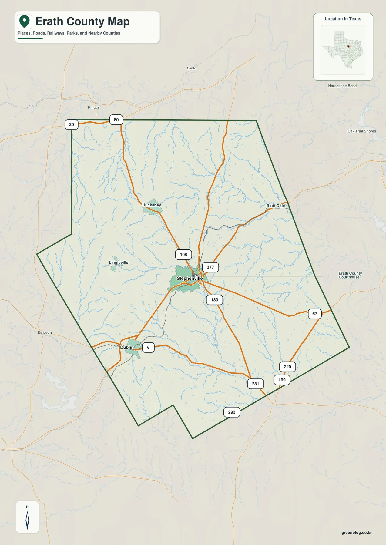
Highways connect Stephenville and Dublin across a wide rural interior
Stephenville is where the county’s most important road lines come together. U.S. 377 approaches from Dublin in the southwest, passes through Stephenville, and continues northeast. U.S. 281 crosses the county north to south through the same area, while State Highway 108 runs north from Stephenville. Other mapped routes extend east and southeast, including the roads labeled 67, 220, and 199. The result is a hub-and-branch pattern centered on Stephenville rather than a single straight corridor cutting through the entire county.
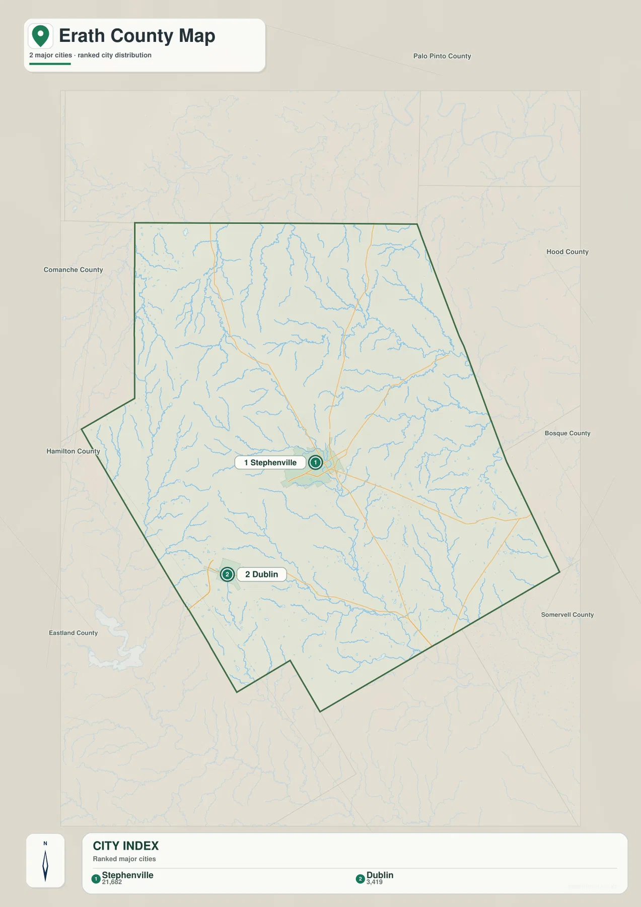
The city map simplifies the settlement picture even further. It ranks Stephenville first and Dublin second, making their separation easy to see at a glance. Stephenville occupies the central part of the map, while Dublin sits in the southwest. Smaller places that appear on the county map, such as Bluff Dale and Huckabay, are not part of the ranked city index. That difference is useful: the city map is best for comparing the two major population centers, while the county map is better when you need the wider network of towns, highways, and boundary references.
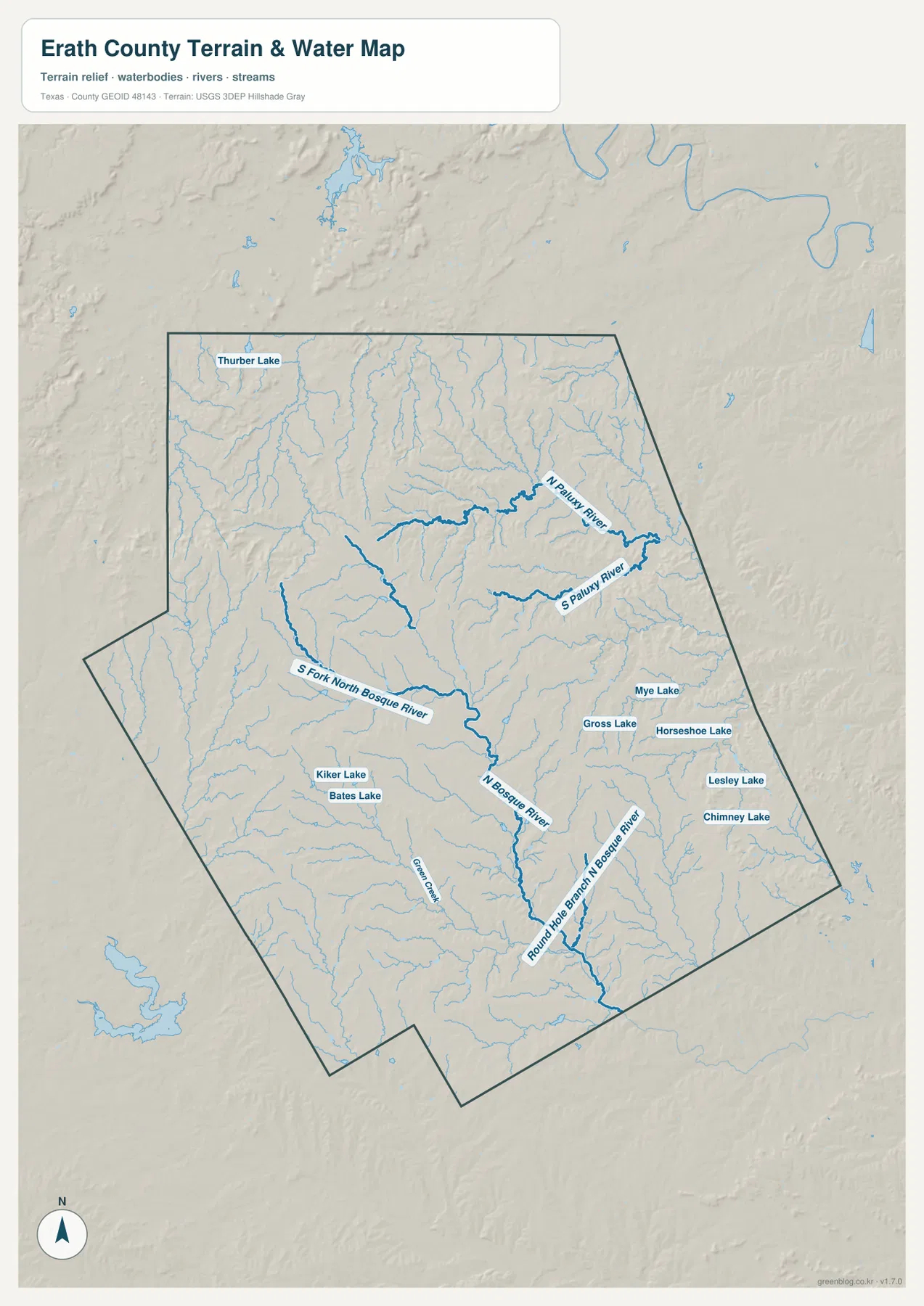
North Bosque and Paluxy headwaters divide the drainage
The water map reveals a much more intricate pattern than the road map. The North Bosque River runs through the central and southern part of the county, and the South Fork North Bosque River approaches from the west before joining that system. In the southeast, Round Hole Branch North Bosque River forms another named branch. The northeastern part of Erath County drains differently: North Paluxy River and South Paluxy River occupy separate valleys there, showing that the county spans more than one prominent headwater network.
Several named lakes add smaller reference points. Kiker Lake and Bates Lake are shown in the southwest-central area, while Mye Lake, Gross Lake, Horseshoe Lake, Lesley Lake, and Chimney Lake appear farther east. Thurber Lake is labeled near the northwestern side, and Green Creek is marked in the southwest. These features are especially useful when a road address or rural parcel is easier to recognize by its nearest creek, branch, or lake than by a town name.
Elevation falls from the western uplands toward eastern valleys
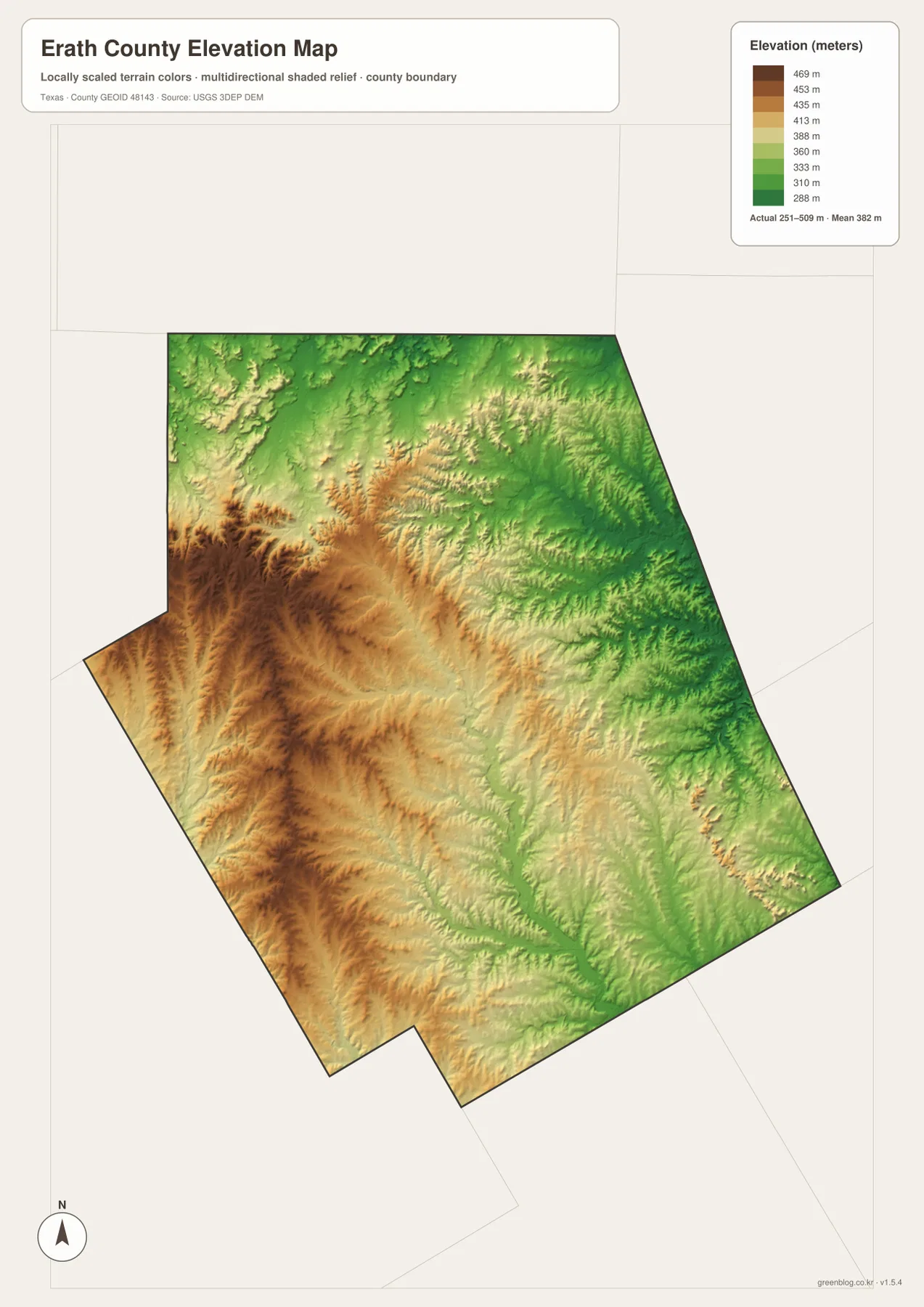
The elevation map shows one of the clearest geographic contrasts in Erath County. The mapped terrain ranges from about 251 to 509 meters, with a mean elevation of about 382 meters. Higher brown and tan terrain dominates much of the western and southwestern side. Moving east, the colors shift toward greens as the land drops into lower, more closely cut valleys. The northeast and east show especially dense drainage relief where numerous small channels have carved the terrain.
This west-to-east drop makes more sense when compared with the water map. Small drainage lines begin across the higher western uplands and descend toward the central and eastern river valleys. Stephenville sits in a middle zone rather than at either elevation extreme, which helps explain why several highways and tributaries can converge near the city without the landscape appearing completely flat. For route planning, local history, or simple map study, the elevation layer helps distinguish a high ridge from a low creek valley that may look close together on a conventional road map.
Details that become clearer when the maps are compared
One map alone can hide relationships that are obvious in another. The county map emphasizes the road hub at Stephenville, but the water map shows how many small tributaries lie between those roads. The elevation map then explains why the eastern half contains so many narrow drainage lines: the lower valleys are more deeply cut than the broad western uplands. The city map adds a final scale check by showing how strongly the two ranked cities, Stephenville and Dublin, stand out from the county’s smaller settlements.
Interstate 20 is another detail that can be misread if the maps are viewed too quickly. It appears just beyond the northern county line rather than passing through the main Stephenville-Dublin corridor. For regional travel it is still an important reference, but inside Erath County the more relevant roads are the routes that converge on Stephenville and connect south or southwest toward Dublin. Starting with the county boundary before following the highway shields prevents a common orientation mistake.
Choose the file that matches the job
For a quick location check, the county map is the most complete single view because it combines the boundary, communities, and major roads. The city map is cleaner when you only need to compare Stephenville and Dublin. Use the water map for creeks, river branches, and named lakes, and add the elevation map when slope, ridges, or valley position matters. Teachers can print one layer for a focused exercise, while field users may prefer the county and water maps together so roads and drainage references are visible at the same time.
Frequently Asked Questions
What is the best place to start on an Erath County map?
Start with Stephenville, then locate Dublin to the southwest and Bluff Dale to the northeast. From Stephenville, follow U.S. 377 and U.S. 281 before comparing the road network with the North Bosque River and the elevation map.
Where are the North Bosque and Paluxy river systems on the map?
The North Bosque River is in the central and southern part of the county, with the South Fork North Bosque entering from the west. North Paluxy River and South Paluxy River are in the northeastern part of Erath County, where they occupy separate valleys.
How much does elevation vary across Erath County?
The provided elevation map shows an actual range of roughly 251 to 509 meters, with a mean near 382 meters. The western and southwestern areas are generally higher, while lower river valleys become more prominent toward the east.
Sources and Reference Data
- USGS The National Map Viewer — Official map viewer for terrain, hydrography, roads, and other geographic layers.
- U.S. Census Bureau TIGER/Line Shapefiles — Boundary and transportation reference data.
- USGS National Hydrography — Reference source for rivers, streams, lakes, and drainage features.
- USGS 3D Elevation Program — Official elevation data program used for terrain and relief reference.
Map File Information
The downloadable ZIP contains the county, city, water, and elevation maps as A3 high-resolution JPG files.
- File Type: JPG
Related Maps
- Palo Pinto County Texas map
- Somervell County
- Shackelford County Texas map
- Stephens County
- Parker County Texas map
Green Map creates custom-edited map images using open geographic data sources such as geoBoundaries, Natural Earth, OpenStreetMap, and government open data.
These maps are edited visual materials, not raw data files, and are provided for education, documents, presentations, and graphic reference.