Wilcox County sits in south-central Georgia, where a small group of towns is spread across a broad rural landscape. Abbeville lies near the eastern side of the county, Rochelle occupies a more central road junction, Pineview is near the north, and Pitts is west of Rochelle. The county’s eastern edge is notably irregular, and the water and elevation maps show why that side of Wilcox County looks different from the higher ground to the west.
This page combines four views of the same county so you can move from basic orientation to more specific questions. The maps show the county boundary and roads, straight-line city connections, named rivers and creeks, and the contrast between western uplands and lower land near the eastern river corridor. You can also download all four Wilcox County maps together as high-resolution JPG files in a ZIP archive.
The goal is not to crowd every road, parcel, or tiny community into one image. Instead, each map highlights a useful part of the county. The boundary map is best for roads and settlement position, the city map helps compare distances from Abbeville, the water map names major streams and ponds, and the elevation map shows a countywide height range of roughly 45 to 139 meters. Used together, they provide a clearer picture of Wilcox County than a single general-purpose map.
Table of Contents
Abbeville on the East, Rochelle at the Road Junction
The county boundary and road map makes the settlement pattern easy to see. Abbeville is close to the winding eastern edge, while Rochelle sits farther inland near the middle of the county. Pineview is near the northern boundary and Pitts is west of Rochelle. Seville appears just outside the western side, and Rhine is labeled east of Abbeville, giving useful reference points beyond the county line. The Wilcox County Courthouse label also appears east of the boundary area near Abbeville.
Road numbers help explain why Rochelle stands out as an internal crossroads. Route 112 runs through the county and passes Rochelle, while Route 30 approaches from the west and continues toward Abbeville. Route 129 follows the eastern side south of Abbeville, and Routes 215 and 233 cross the southern half. On the west, the map also labels 280, 159, 90, and 257. The overall pattern is not a single north-south corridor; several roads approach Rochelle from different directions and then spread toward the county’s outer areas.
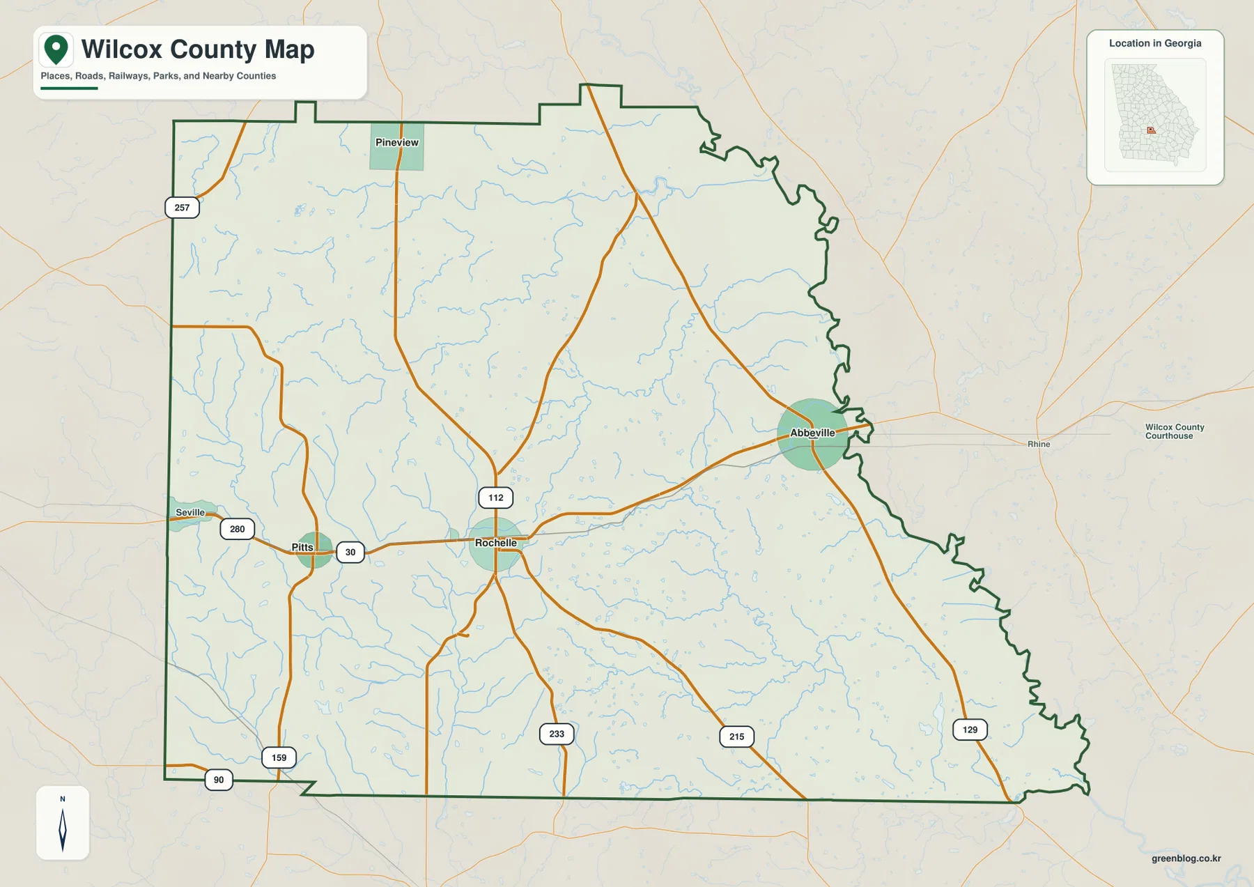
The eastern boundary has a much more irregular outline than the long straight segments on the west and south. That shape becomes more meaningful after comparing it with the water map, where the Ocmulgee River and connected drainage occupy the eastern side. Abbeville therefore appears close to both the county edge and the lower river country, while Rochelle is farther from that boundary and closer to the interior road network.
City Connections from Abbeville to Rochelle, Pineview, and Pitts
The city-connections map uses Abbeville as the hub and compares three other labeled places. Rochelle is shown about 9 miles from Abbeville, while Pineview and Pitts are each about 14 miles away. These are straight-line distances, not driving distances, so a road trip between the towns may be longer depending on the route. Even with that limitation, the map quickly shows that Rochelle is the closest of the three and that Pineview and Pitts occupy different sides of the county at similar direct distances from Abbeville.
The four settlements also occupy very different positions in the road network. Rochelle is surrounded by multiple road approaches and acts as the clearest central junction. Abbeville is an eastern hub, but its position near the county boundary means it is not centrally located inside the county shape. Pineview is isolated toward the north, while Pitts sits on the western side near routes leading toward Dooly and Crisp County. This makes the city map especially useful when a simple town list does not explain how far apart the communities are.
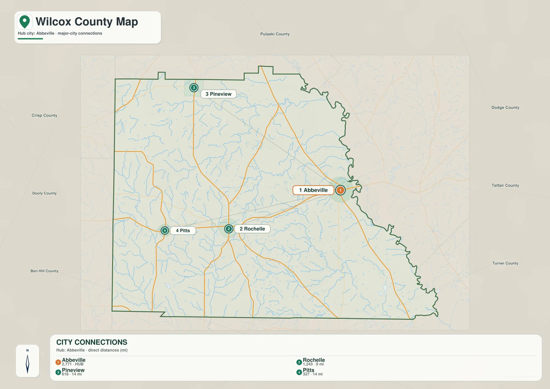
The surrounding-county labels add another layer of orientation. Pulaski County is shown to the north, Dodge and Telfair to the east, Turner to the southeast, Ben Hill to the southwest, and Dooly and Crisp to the west. These labels help place Wilcox County within south-central Georgia without requiring a separate statewide map. They also show why different sides of Wilcox County connect toward different nearby county seats and regional routes.
The current source material also notes that Wilcox County was established in 1857 and identifies Abbeville as the county seat. Agriculture, forestry, rail history, and small-town services are part of the county background described in the existing article. The present maps do not attempt to reconstruct every historic rail line, but the spacing of Abbeville, Rochelle, Pineview, and Pitts still reflects a county where small incorporated places are separated by large rural areas.
Ocmulgee River Country and the Interior Creek Network
The water map gives the eastern side of Wilcox County a very different character from the road map. The Ocmulgee River is labeled along the northeastern and eastern side, close to the county’s irregular boundary. Cedar Creek and Brushy Creek occupy the north-central area, while Folsom Creek runs through the middle. Sagegrass Creek appears to the east, and House Creek and Ball Creek cross the southern and southeastern portions of the county. These named channels sit within a much denser web of smaller unnamed tributaries.
On the western side, the map also labels the Alapaha River and shows numerous small drainage lines feeding through the rural landscape. Clements Creek appears in the south-central area. The map is useful precisely because it does not treat the county as a flat blank space between towns: many small valleys and stream courses divide the land between Rochelle, Abbeville, and the outer county boundary. Comparing this view with the road map helps explain why local roads frequently bend, cross streams, or follow higher ground.
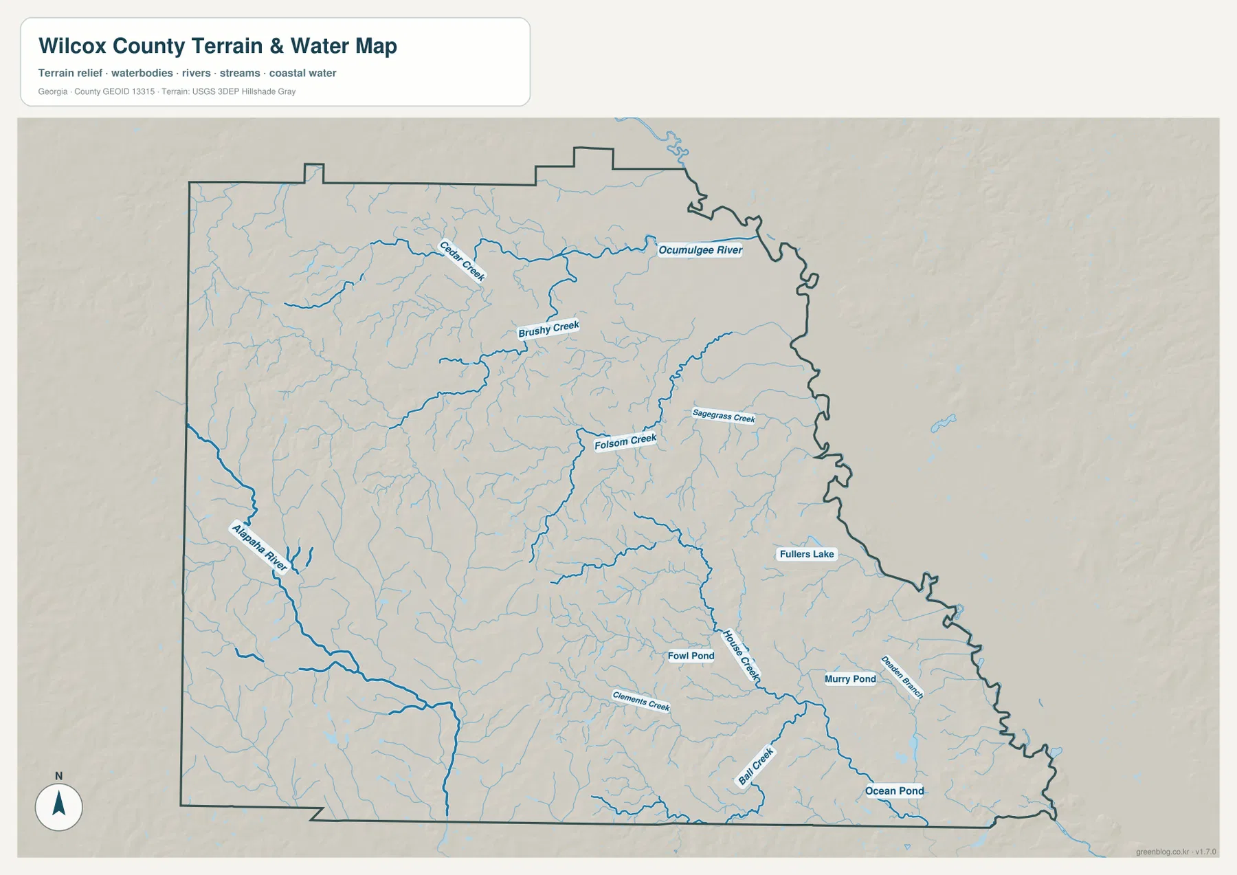
Several small water bodies are labeled as well, including Fullers Lake, Fowl Pond, Murry Pond, and Ocean Pond. Their presence is useful for local orientation, but they should not be read as a complete inventory of every pond or wetland in the county. The water map is a reference for the location of rivers, creeks, and visible water bodies; it is not a flood-hazard map, navigation chart, parcel map, or legal wetland determination.
The relationship between water and settlement becomes clearer near Abbeville. The town sits close to the eastern river corridor, while Rochelle is farther inland among a wider spread of smaller tributaries. That difference is also visible in the elevation map. The lower eastern terrain follows the same general side of the county as the Ocmulgee River, whereas the western half contains more pronounced ridges and short valleys.
Higher Western Ridges and Lower Ground Toward the East
The elevation map shows a countywide range of about 45 to 139 meters, with a mean near 90 meters. The western side is dominated by brown and tan shades that mark the higher ground. Those colors are strongest in the southwest and northwest, where repeated ridges and narrow valleys create more relief. Moving toward the center, the colors shift through yellow and light green, and the eastern side becomes broadly greener and lower.
This west-to-east contrast matches the water pattern. The Ocmulgee River side of the county lies in lower terrain, while the western uplands are cut by many short tributary valleys. The central area around Rochelle sits between those two broad settings. Abbeville is closer to the lower eastern ground, so the city and elevation maps together show why the two main towns occupy different terrain even though they are only a modest distance apart.
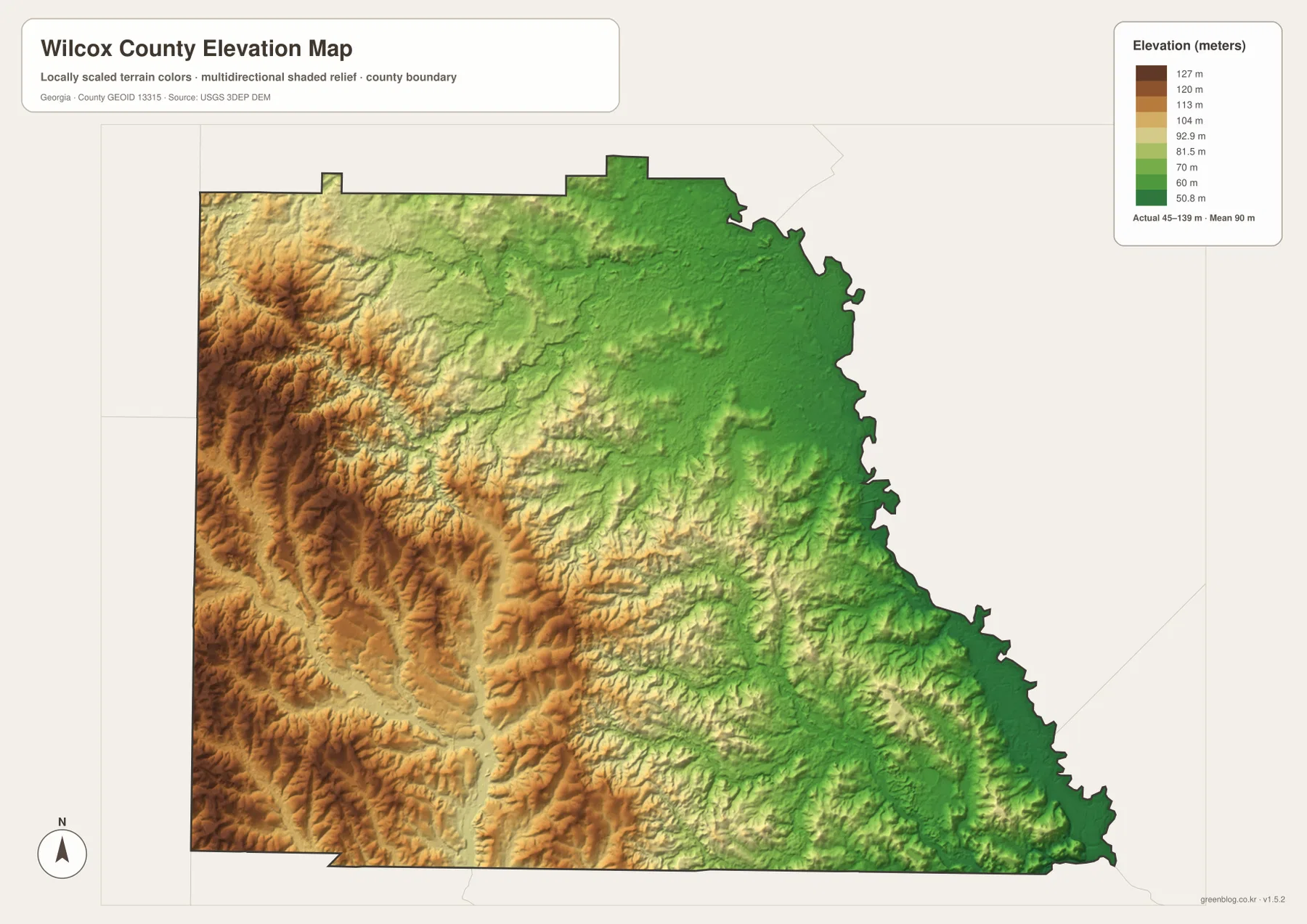
The shaded terrain should be read as a countywide relief reference rather than a survey. It is excellent for seeing broad ridges, valleys, and the direction in which the land becomes lower, but it should not be used to determine the exact elevation of a house lot, road shoulder, bridge, or construction site. Engineering or survey work requires more detailed elevation products and site-specific measurements.
Which Wilcox County Map Is Best for Your Task?
For a quick county overview, start with the boundary and road map because it places Abbeville, Rochelle, Pineview, and Pitts in the same frame with the numbered routes. If your question is specifically about how the towns relate to Abbeville, the city-connections view is faster because it shows direction and direct distance. For natural features, the water map provides the named rivers and creeks that are easy to miss on the general map. The elevation view is best when the main question is why the western side looks hillier and the eastern river side lower.
The maps become most useful when they are paired. A reader looking at Abbeville can use the boundary map to locate the town, the water map to see the nearby river corridor, and the elevation map to understand the lower terrain. Rochelle makes a different comparison: the road map shows its central junction, the city map gives its 9-mile straight-line relation to Abbeville, and the elevation map places it between the western uplands and the eastern lowlands. Pineview and Pitts can be handled the same way without forcing every feature into one crowded image.
The downloadable archive is intended for readers who want the maps beyond the webpage. The body uses lighter WEBP previews for fast viewing, while the ZIP contains four original high-resolution JPG maps. They can be printed, inserted into a local-history or classroom document, or kept together as a reference set when comparing roads, waterways, settlement locations, and terrain.
Frequently Asked Questions
Is Abbeville or Rochelle closer to the middle of Wilcox County?
Abbeville is the county seat, but it lies close to the eastern boundary. Rochelle is more centrally placed inside the county and is surrounded by a stronger multi-direction road junction, so it works well as a geographic reference point for the county interior.
Why is the Ocmulgee River side lower on the elevation map?
The supplied elevation map shows lower green terrain along the eastern river side and higher tan and brown ridges in the west. Across the county, the mapped elevation ranges from roughly 45 to 139 meters, and the major river and tributaries occupy many of the lower valleys.
What is included in the downloadable map set?
The ZIP contains four high-resolution JPG files: the county boundary and road map, the city-connections map, the water map, and the elevation map. The images shown in the article are lighter WEBP previews.
Sources and Reference Data
The county descriptions above prioritize features visible in the supplied maps. The following external resources provide additional county background and authoritative boundary, hydrography, and elevation data.
- New Georgia Encyclopedia: Wilcox County
- City of Abbeville official website
- U.S. Census Bureau TIGER/Line Shapefiles
- USGS National Hydrography
- USGS 3D Elevation Program
Map File Information
Download the Wilcox County boundary, city-connections, water, and elevation maps together as original JPG files.
- File Type: ZIP archive containing JPG files
Related Maps
Green Map creates custom-edited map images using open geographic data sources such as geoBoundaries, Natural Earth, OpenStreetMap, and government open data. These maps are edited visual materials, not raw data files, and are provided for education, documents, presentations, and graphic reference.