Whitfield County is easiest to understand as a long north-south county shaped by Dalton, a major transportation corridor, and a series of narrow ridges and valleys. Dalton occupies the strongest urban area near the middle-south of the county, while Tunnel Hill, Varnell, and Cohutta extend the settlement pattern northward. The supplied maps also show a dense creek network and a marked elevation contrast between the higher western ridges and the lower terrain across much of the east.
You can download all four Whitfield County maps on this page as high-resolution A3 JPG files in one ZIP. The browser previews cover the county boundary and roads, the relative positions of Dalton and the smaller cities, named creeks and lakes, and an elevation surface ranging from about 187 to 555 meters. Together they are useful for printed reference sheets, classroom geography, local research, and presentations without forcing every type of information onto one crowded map.
Table of Contents
Dalton sits where the county’s major road network comes together
The general county map makes Dalton the clearest reference point. The developed area around the city is much broader than the other labeled communities, and the map also identifies the Whitfield County Courthouse, Dalton State College, and Hamilton Medical Center. From this central area, roads spread toward every side of the county, while the main north-south corridor continues through the long county shape.
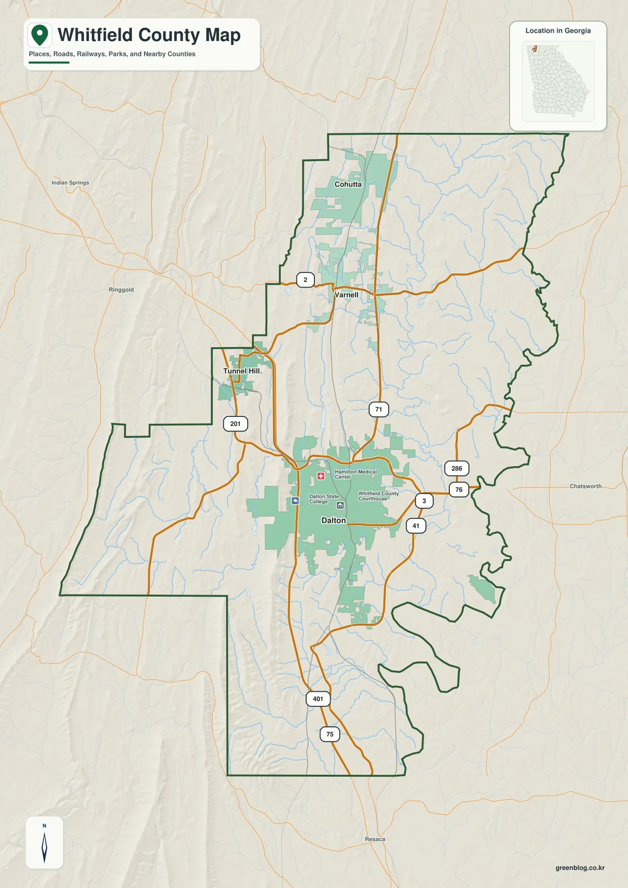
Interstate 75 is the most prominent transportation line, running from the southern end of the county through the Dalton area and continuing north. U.S. 41 is also labeled around Dalton, while Route 2 crosses the northern part near Varnell. Route 71 links the northern section with the Dalton area, Route 201 serves the Tunnel Hill side, and Routes 76 and 286 are visible east of Dalton. The map is therefore useful for seeing why Dalton functions as a practical road hub rather than simply locating the county seat.
The outline becomes especially irregular on the eastern side and around the southern extensions, while the western side lies beside stronger ridge relief. This is a county reference map rather than a parcel or legal-survey product, so it should be used for broad geographic orientation rather than property decisions. The attached source material identifies Whitfield County as established in 1851 and Dalton as the county seat. It also notes manufacturing and the flooring industry as important parts of Dalton and the county’s local context, although the map itself is focused on geography rather than industrial sites.
The city map stretches from Dalton north to Cohutta
The city-connections map removes much of the road detail and emphasizes four places: Dalton, Tunnel Hill, Varnell, and Cohutta. Dalton is the southern hub in this group. Tunnel Hill sits northwest of it, Varnell lies farther north, and Cohutta is the northernmost highlighted city. That simplified view makes it clear that Whitfield County does not have one continuous urban center extending from end to end; the smaller cities are separated from Dalton and from one another by a mix of valleys, ridges, streams, and less developed land.
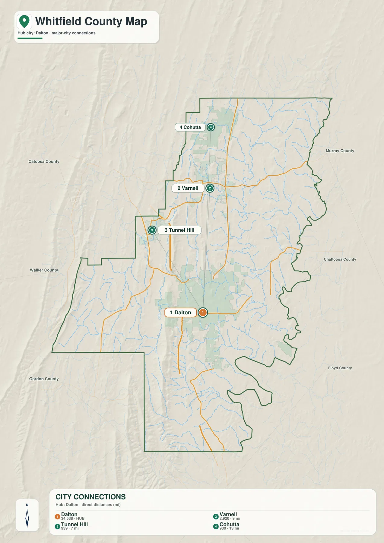
The connection panel printed on the map gives straight-line distances from Dalton of about 7 miles to Tunnel Hill, 9 miles to Varnell, and 13 miles to Cohutta. Those are not driving distances. The same panel prints figures of 34,538 for Dalton, 2,920 for Varnell, 939 for Tunnel Hill, and 930 for Cohutta, which helps explain the very different visual roles of the four places on the map. Because those values are part of the supplied graphic, readers who need current population figures should confirm them with a current statistical source.
This simplified map is most useful when the question is about direction or spacing. It quickly shows that Varnell and Cohutta lie north of Dalton and that Tunnel Hill is offset to the northwest. If the goal is to plan a route or identify a numbered highway, the general map adds the road network that the city view deliberately leaves in the background.
Coahulla Creek and smaller tributaries thread through the valleys
The terrain-and-water map shifts attention away from roads and toward the low ground between ridges. Little Creek is labeled in the north and feeds into the more prominent Coahulla Creek system. Farther south, Mill Creek crosses the interior, while Drowning Bear Creek runs through the southeastern side. Swamp Creek and Dry Creek appear near the southern end, and the Conasauga River is labeled just beyond the county’s lower edge as a larger regional watercourse.
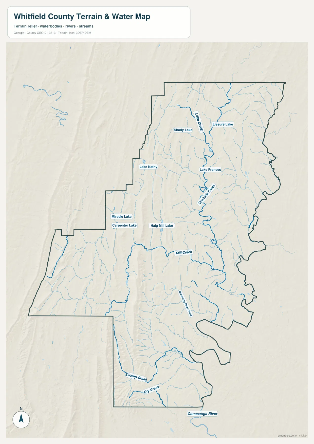
Several named lakes are scattered through the northern and central parts of the county. Shady Lake and Leisure Lake are shown in the north, Lake Frances lies farther down the Coahulla Creek system, and Lake Kathy appears to the west. Miracle Lake, Carpenter Lake, and Haig Mill Lake are labeled closer to the middle-west. The pattern is not dominated by one large reservoir; instead, the map shows many narrow streams and a number of smaller water bodies occupying different valleys.
The shaded relief behind the blue lines helps explain why the streams bend and branch the way they do. Watercourses generally occupy lower passages between the elongated ridges, especially across the western and central parts of the county. This map is not a flood-zone, wetland-regulation, parcel, or navigation map, however. It is best used to locate named water features and compare them with the surrounding terrain at county scale.
Western ridges rise sharply within a 187–555 meter elevation range
The elevation map shows an actual county range of roughly 187 to 555 meters, with a mean of about 258 meters. The strongest brown and tan colors occur along long, narrow ridges in the west and southwest. Similar but smaller ridge bands continue through parts of the center. Much of the eastern half is greener and lower, creating a clear contrast between the county’s ridge country and its broader lower areas.
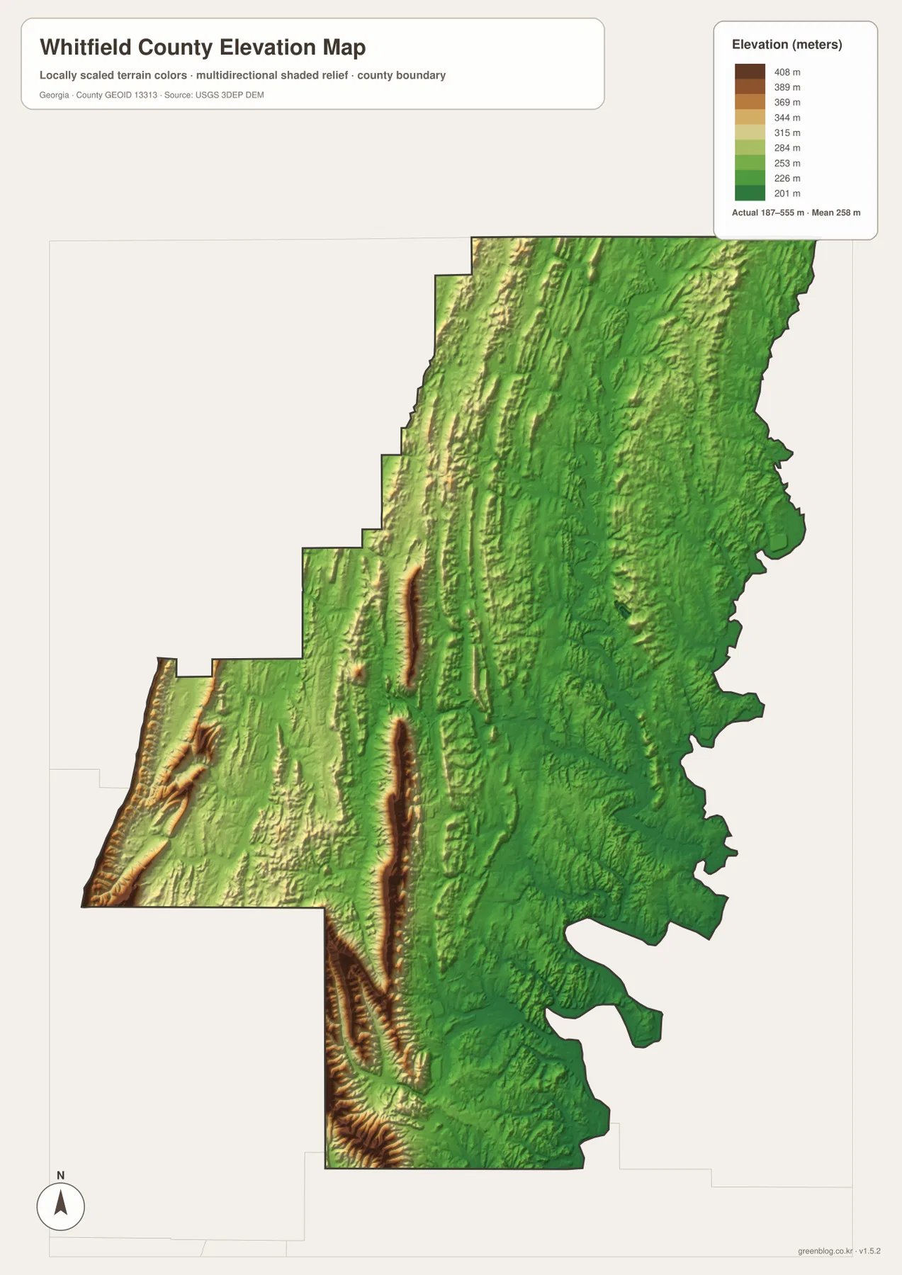
Dalton appears to occupy lower country between the strongest ridge lines rather than the highest ground. That relationship helps explain the long north-south pattern seen on the road and city maps. Major transportation and developed areas can follow the more open valley floor, while the higher ridges remain visually distinct on the elevation surface. To the west of Dalton and around the Tunnel Hill side, the relief is much stronger than across large parts of the east.
The elevation layer is designed for county-scale comparison. Its colors are useful for identifying broad high and low areas and for showing how valleys cut between ridges, but they should not be treated as survey-grade contours or a precise elevation at a particular property. Engineering, drainage, construction, and other site-specific decisions require more detailed official elevation data.
Terrain helps explain the placement of roads, cities, and streams
Looking at the four map views together reveals a consistent pattern. Dalton and the main north-south transportation corridor occupy lower terrain between prominent ridges, while many creeks use the same valley system at a finer scale. The city map then shows how Varnell and Cohutta extend northward from Dalton, with Tunnel Hill positioned to the northwest near stronger western relief. This is more informative than treating the road, water, and elevation layers as unrelated subjects.
For example, Tunnel Hill is easy to place on the city map, Route 201 adds its road context on the general map, and the elevation layer shows why the western side looks more rugged. The water map fills in another part of the picture by tracing tributaries through the lower ground between those ridges. Around Dalton, the same comparison makes the city look less like an isolated dot and more like a developed center occupying a valley corridor with routes extending north, south, east, and west.
This combined reading is useful for education and local orientation because it turns place names into a geographic explanation. A student can see not only where Dalton or Cohutta is located, but also how the county’s elongated ridges, lower valleys, and creek network influence the overall appearance of the map. A researcher or presenter can choose only the layer needed for a particular topic rather than overloading one figure with every detail.
Choosing the best map file for print or research
Use the general map when county boundaries, Dalton, major roads, and selected landmarks are the priority. The city map is cleaner for comparing Dalton with Tunnel Hill, Varnell, and Cohutta. The water map is the better choice for locating Coahulla Creek, Mill Creek, smaller tributaries, and lakes, while the elevation map makes the western ridge-and-valley relief easiest to explain. The WEBP images above are page previews; the ZIP below contains the high-resolution A3 JPG versions.
- County and roads: use the general reference map for Dalton, the boundary, and major numbered routes.
- City spacing: use the city-connections map for the relative positions and straight-line distances of the four highlighted cities.
- Creeks and lakes: use the terrain-and-water map for named water features and valley context.
- Ridges and valleys: use the elevation map for the 187–555 meter county relief range and broad high-low contrast.
Frequently Asked Questions
Why does western Whitfield County look much more rugged than the east?
The supplied elevation map concentrates the highest terrain along long ridges in the west and southwest, while much of the eastern half is shown at lower elevations. The map’s actual range is about 187 to 555 meters, so the contrast between the ridge tops and lower valleys is strong enough to be obvious even at county scale.
Which map is best for comparing Dalton with Tunnel Hill, Varnell, and Cohutta?
The city-connections map is the fastest choice because it isolates those four places and prints straight-line distances from Dalton. Use the general county map afterward if you also need numbered roads or a more detailed view of the surrounding geography.
Can the water map be used to determine flood risk or property boundaries?
No. It is a geographic reference for named streams, lakes, and their relationship to the terrain. Flood zones, wetland regulation boundaries, legal parcels, and site drainage decisions require the current specialized data published for those purposes.
Map File Information
This ZIP contains four high-resolution A3 JPG maps of Whitfield County covering the county reference view, city connections, waterways, and elevation.
- Included Files: County map, city map, water map, elevation map
- File Type: ZIP containing four JPG files
Related Maps
Sources and References
County background and local context can be checked through the U.S. Census Bureau QuickFacts, the City of Dalton’s official history, and the New Georgia Encyclopedia entry for Whitfield County. The nature of the water and elevation data can be reviewed through USGS National Hydrography and the USGS 3D Elevation Program.
Green Map creates custom-edited map images using open geographic data sources such as geoBoundaries, Natural Earth, OpenStreetMap, and government open data. These maps are edited visual materials, not raw data files, and are provided for education, documents, presentations, and graphic reference.