White County changes character quickly from south to north. Cleveland sits in the southern half as the county seat and a clear road hub, while Helen lies much farther north where the terrain becomes steeper and more deeply cut by mountain valleys. The general map also labels Yonah and Sautee-Nacoochee, helping connect the two main cities with the communities and routes between them. This is a county where roads, streams, and elevation make more sense when they are viewed together rather than as separate facts.
You can download all four White County maps on this page as high-resolution A3 JPG files in one ZIP. The browser previews cover the county boundary and roads, the placement of Cleveland and Helen, the Chattahoochee River and smaller streams, and an elevation range that runs from about 334 to 1,339 meters. The four views are useful for print, classroom geography, local research, and presentations because each one removes some detail and emphasizes a different part of the county.
Table of Contents
Cleveland anchors the south while routes climb toward Helen
The county map places Cleveland near the center of the southern half, where several numbered routes converge or pass nearby. Routes 11 and 129 are shown around Cleveland, while 75 and 17 continue north toward the Helen area. Other labeled routes spread toward different sides of the county: 115 heads east of Cleveland, 384 reaches the southeast, 348 appears in the northwest, and 255 and 356 serve the northeastern side. The result is not a simple north-south corridor. Cleveland works as the most obvious road reference point, but multiple branches lead into different valleys and neighboring areas.
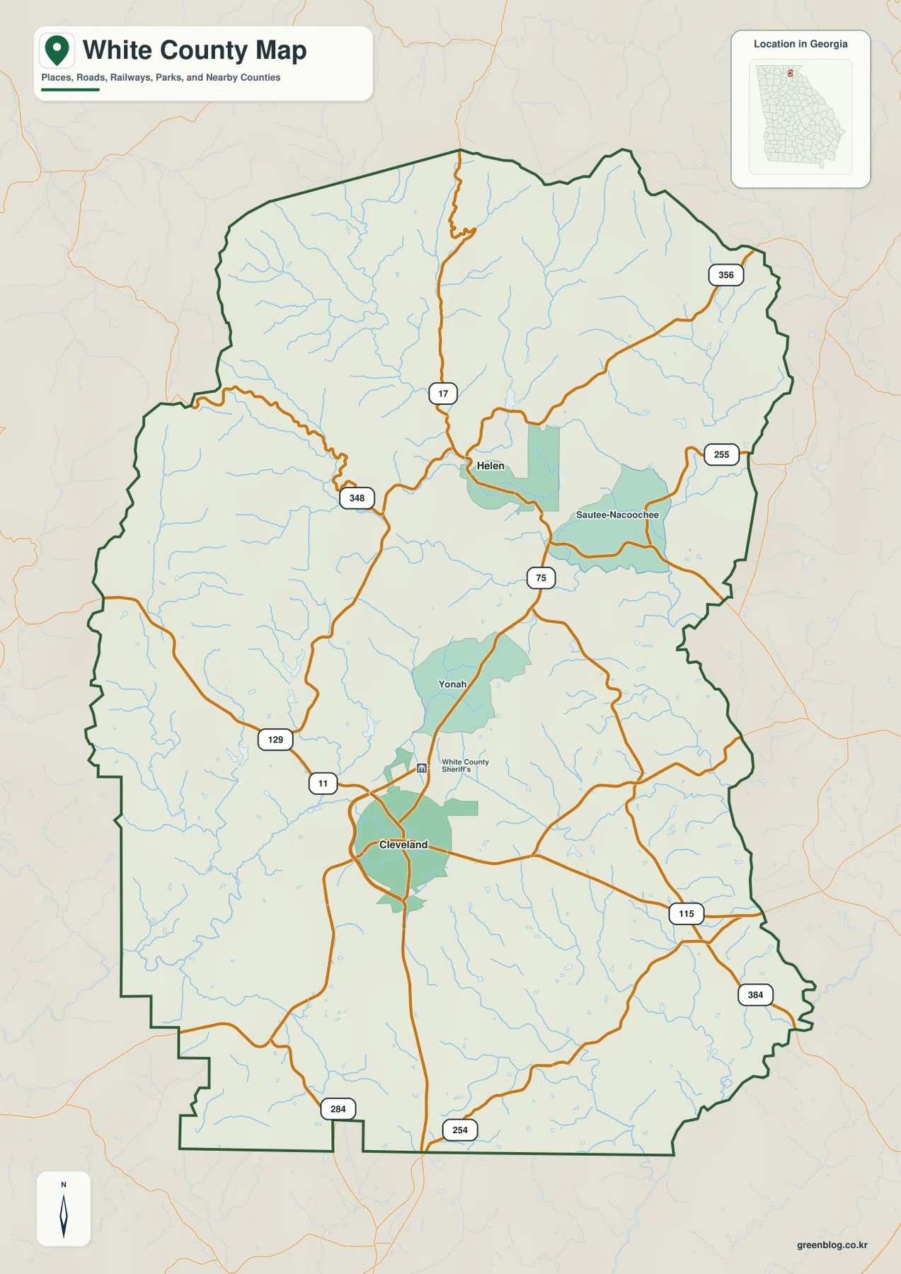
Helen is set well north of Cleveland, and the map places Yonah between the two areas with Sautee-Nacoochee to the east of Helen. That spacing matters because it shows that the county’s developed places are separated by a landscape of hills, valleys, streams, and forested mountain country rather than one continuous urban strip. In the northern part of the map, the roads bend more sharply and the boundary becomes more irregular. Those visual changes match the much stronger relief shown later on the elevation map.
The source material identifies White County as established in 1857 and Cleveland as the county seat. It also describes mountain tourism, vineyards, forests, rivers, and access to the Blue Ridge foothills as important parts of the local setting. Helen is identified as a major tourism center in the northern mountain area. The general county map is useful for placing those references on the ground, but it is not a parcel map, a complete road atlas, or a trail map.
| State | Georgia |
|---|---|
| County | White County |
| County seat | Cleveland |
| Established | 1857 |
| Major cities highlighted | Cleveland and Helen |
| Elevation map actual range | About 334–1,339 m; mean about 542 m |
The city map makes the Cleveland–Helen separation easy to see
The city-distribution map strips away much of the road labeling and highlights two major cities: Cleveland and Helen. Cleveland is positioned in the lower half of the county, while Helen is well to the north. That simple view makes the county’s internal spacing easier to understand than the busier reference map. Instead of suggesting one continuous population center, it shows two distinct places separated by a broad mountain-and-valley landscape.
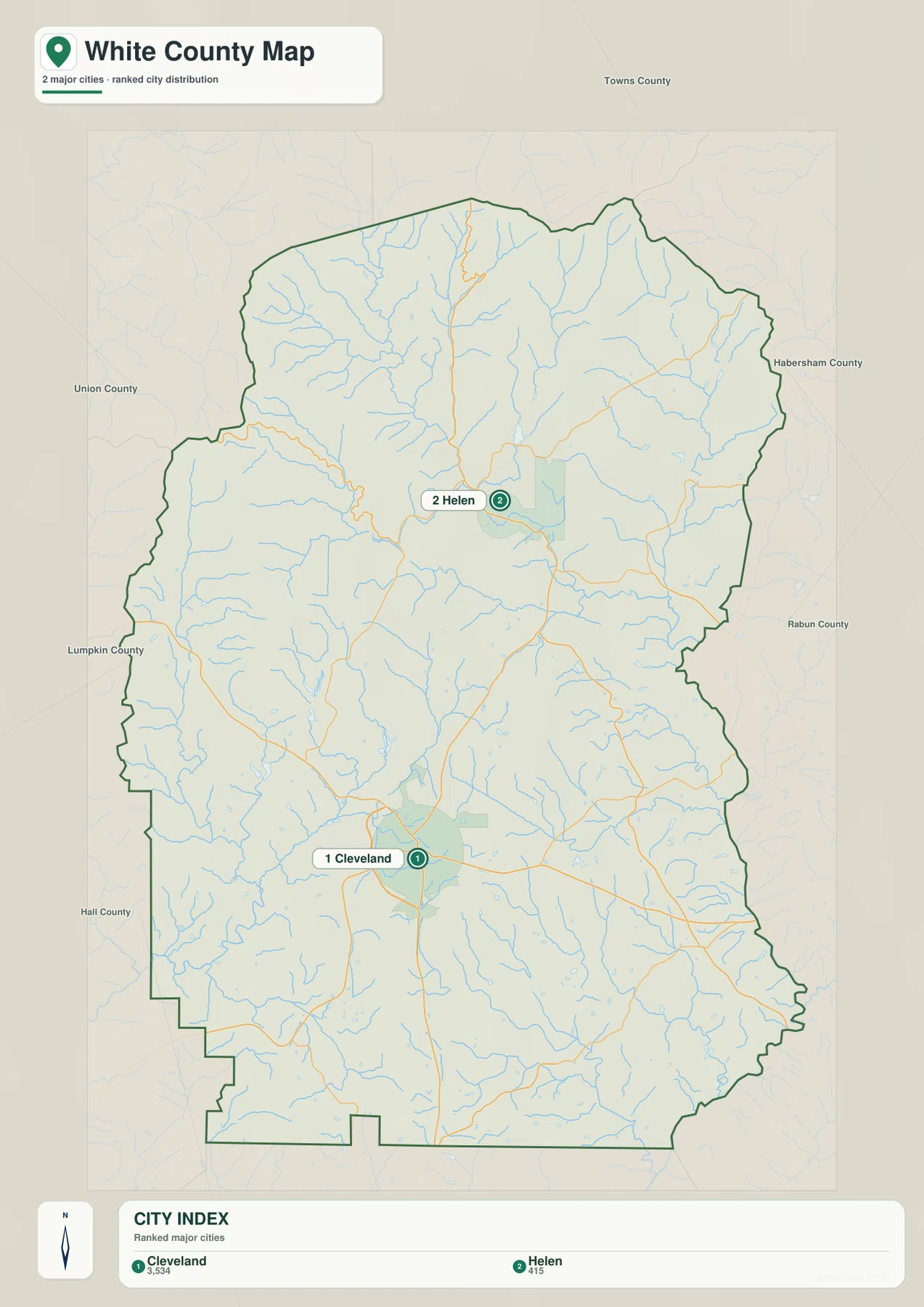
County names around the outside of the map provide additional orientation. Towns County is labeled to the north, Union and Lumpkin appear to the west, Hall is shown toward the southwest, and Habersham appears on the eastern side; Rabun is also labeled farther east as regional context. These surrounding labels are useful when a reader is trying to understand which direction a route leaves White County, although the map should not be treated as a detailed legal boundary reference for every adjoining jurisdiction.
For a quick location question, this is often the easiest map to use. If the goal is simply to show that Helen is north of Cleveland, the city view answers that without the distraction of dozens of route numbers. If the goal is to explain how a trip moves between the two, the general county map adds the road network and intermediate labels needed for the next step.
The Chattahoochee and smaller creeks fill the mountain valleys
The terrain-and-water map gives White County a much more intricate appearance. The Chattahoochee River is the strongest named watercourse on the map, running through the northern half and then continuing across the interior. Town Creek and Tesnatee Creek are prominent on the western side, Blue Creek crosses the middle, and White Creek and Mossy Creek are labeled farther south. Numerous thinner tributaries branch into the main channels, especially in the rugged northern half where the shaded relief shows closely spaced ridges and valleys.
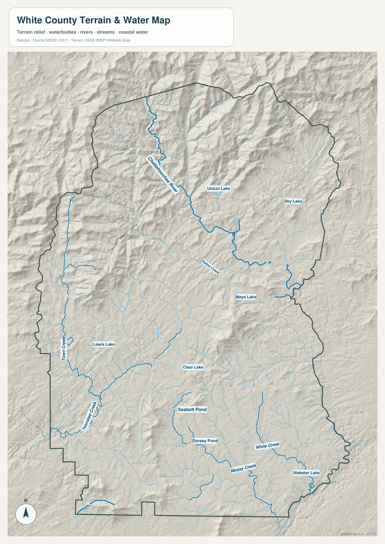
Several small lakes and ponds are labeled as well. Unicoi Lake and Sky Lake appear in the northern half, Mays Lake is farther south, and Clear Lake sits near the central-southern portion. Lewis Lake is labeled on the western side, while Seabolt Pond, Dorsey Pond, and Webster Lake appear in the southern part of the county. The map therefore does not revolve around one large reservoir. Its water pattern is made up of a major river, many narrow creeks, and scattered smaller water bodies tucked into different valleys.
The shaded terrain behind the water lines is important. Many streams follow the low spaces between ridges, so their paths explain why the county’s relief looks so dissected. That does not make this a flood-risk map, however. The blue lines show water features for geographic reference; they do not establish flood zones, wetland regulation boundaries, navigability, property lines, or the amount of water that will be present on a particular day.
Elevation rises dramatically toward the northern ridges
The elevation map gives the clearest visual explanation for the contrast between southern and northern White County. Its actual values span roughly 334 to 1,339 meters, with a mean of about 542 meters. Much of the south and southeast is rendered in lower green tones, while the north changes to yellow, tan, and dark brown across a dense series of ridges. The northwest and north-central sections contain the strongest concentration of high terrain, and deep green valley cuts run between the higher slopes.
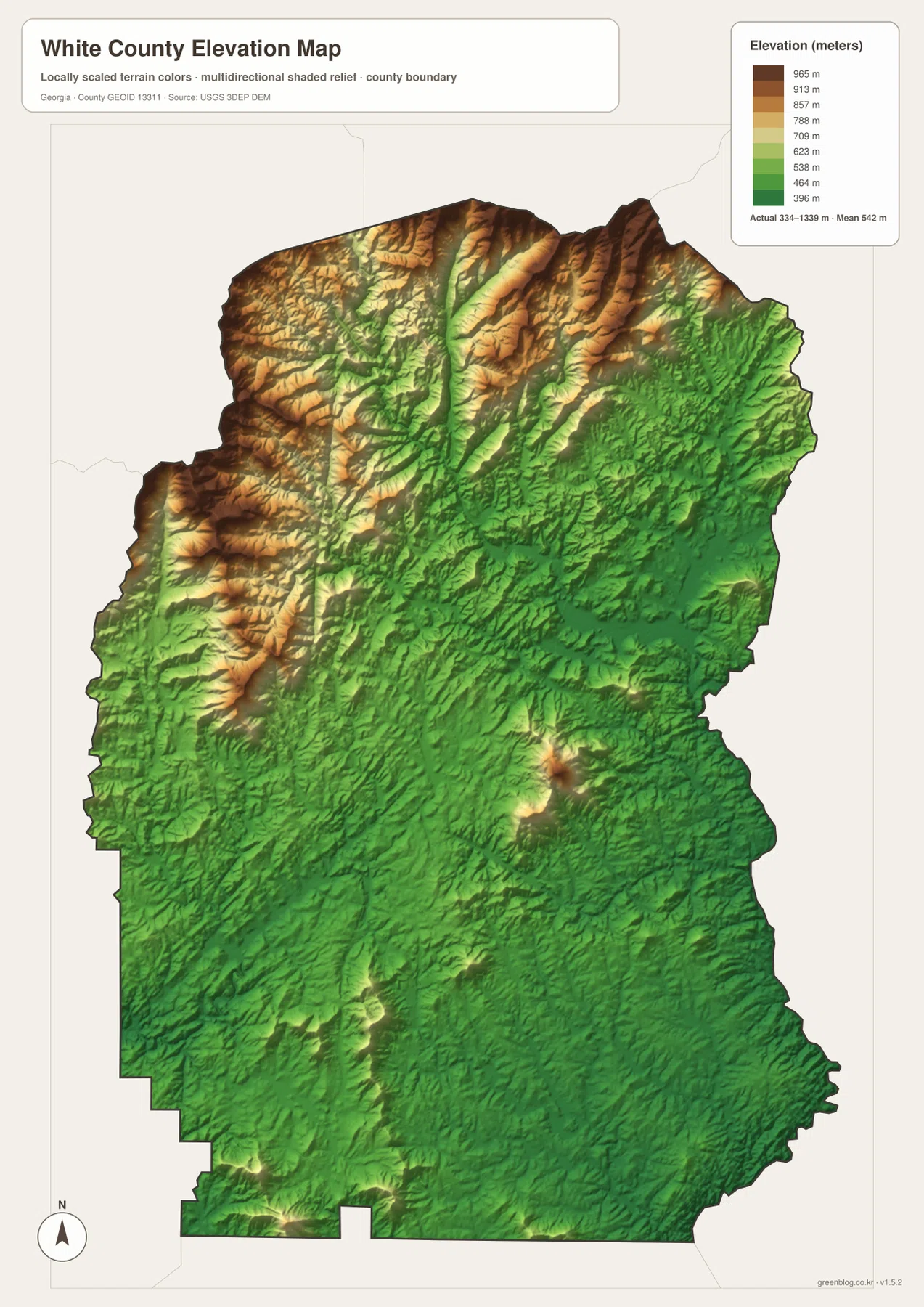
This change helps explain features that are only suggested on the road map. In the north, roads and streams often bend through narrow passages rather than following long straight lines. The Chattahoochee and its tributaries occupy lower channels between the ridges, while the highest terrain rises sharply around them. Helen’s northern setting therefore looks very different from the broader, lower country around Cleveland even though both places are within the same county.
The elevation layer is meant for relative comparison at county scale. It is useful for showing where the terrain is broadly high, low, steep, or valley-cut, but the color transitions are not a substitute for a survey or engineering elevation at a specific property. For construction, drainage design, route engineering, or other site-level decisions, a more precise official source is required.
Four map views answer different questions about the same county
White County becomes easier to understand when the maps are used in sequence. Start with the county reference map to locate Cleveland, Helen, the boundary, and the main numbered roads. The city map then reduces the detail so the north-south separation of the two major cities stands out. The water map fills the space between those cities with the Chattahoochee River, tributaries, lakes, and narrow valleys. Finally, the elevation map explains why the northern road and stream network is so much more twisted and compressed than the southern one.
One practical comparison is the corridor from Cleveland toward Helen. The county map provides the road labels and intermediate places. The water map shows that the route crosses and parallels a landscape divided by streams, while the elevation map shows rapidly increasing relief toward the north. A second comparison is the southern half of the county, where the elevation colors are generally lower and the ridges less dominant. Looking back at the road map after seeing that terrain makes the broader spacing of southern routes easier to understand.
Not every project needs every map. Use the county map when a report needs boundaries and roads; use the city map for a clean Cleveland-versus-Helen location graphic; use the water map for river, creek, and lake references; and use the elevation map when the distinction between Blue Ridge mountain country and lower southern hills is the main point. For classroom or presentation work, placing two or more of the maps side by side is often more informative than adding more labels to a single crowded image.
- Boundary and road reference: use the general county map.
- Cleveland and Helen placement: use the city-distribution map.
- Chattahoochee River, creeks, lakes, and ponds: use the terrain-and-water map.
- High northern ridges and lower southern terrain: use the elevation map.
The page previews use WEBP for efficient browser viewing. The downloadable package contains four high-resolution A3 JPG files, which are better suited to printing, slide decks, classroom handouts, and local-reference documents. These maps are geographic references rather than legal parcel, flood, or engineering products, so specialized decisions should still rely on the appropriate official datasets.
Frequently Asked Questions
Why does northern White County look so much higher than the south?
The elevation map shows a sharp increase in relief toward the northern ridges, with actual values reaching about 1,339 meters. The source material places the county at the Blue Ridge foothills, and the map shows that mountain terrain most strongly in the north and northwest while the southern half is lower and more gently rolling.
Which map is best for comparing Cleveland and Helen?
The city-distribution map is the quickest way to compare their north-south positions. If you also need the numbered roads and intermediate places between them, pair it with the general county map.
Can the water and elevation maps be used for flood or property decisions?
No. They are county-scale geographic references showing water features and relative terrain. Flood zones, legal property boundaries, engineering elevations, and site-specific drainage decisions require the current official datasets intended for those purposes.
Map File Information
This ZIP contains four high-resolution A3 JPG maps of White County covering the county reference, city distribution, water features, and elevation.
- Included Files: county map, city map, water map, elevation map
- File Type: ZIP containing four JPG files
Related Maps
Sources
These references provide county background and official data context for boundaries, water features, and elevation.
- White County official geography page
- U.S. Census Bureau QuickFacts – White County, Georgia
- New Georgia Encyclopedia – White County
- U.S. Census Bureau TIGER/Line boundary data
- USGS National Hydrography
- USGS 3D Elevation Program
Green Map creates custom-edited map images using open geographic data sources such as geoBoundaries, Natural Earth, OpenStreetMap, and government open data. These maps are edited visual materials, not raw data files, and are provided for education, documents, presentations, and graphic reference.