Wichita County lies in western Kansas, where Leoti forms the clear administrative and transportation center within a broad High Plains landscape. The county has few major settlements, so long rural roads, creek valleys, and gradual elevation changes are more important geographic references than urban development. Leoti sits near the middle of the county, while Marienthal, Selkirk, Lydia, and other small place names are scattered across agricultural country. High-resolution map files are available for download in the section below.
This guide follows Leoti, the main highway junctions, Ladder Creek, White Woman Creek, Sand Creek, and terrain ranging from about 930 to 1,070 meters. WebP previews are available for quick viewing, and the matching high-resolution JPG files can be downloaded together in one ZIP for printing, classroom work, or offline reference.
Table of Contents
Leoti anchors the K-25 and K-96 highway crossroads
Leoti sits slightly south of the county center where K-96 runs east–west and K-25 crosses north–south. Kansas Department of Transportation records confirm that K-25 reaches the K-96 junction at Leoti and continues toward the Logan County line, while K-96 crosses Wichita County from the Greeley County side through Leoti toward Scott County.
Wichita County’s official website places the county offices and courthouse in Leoti, and the Kansas Historical Society identifies the town as the county seat. That administrative role matches the map, where roads and public landmarks are concentrated around Leoti before the county opens into a much sparser rural grid.
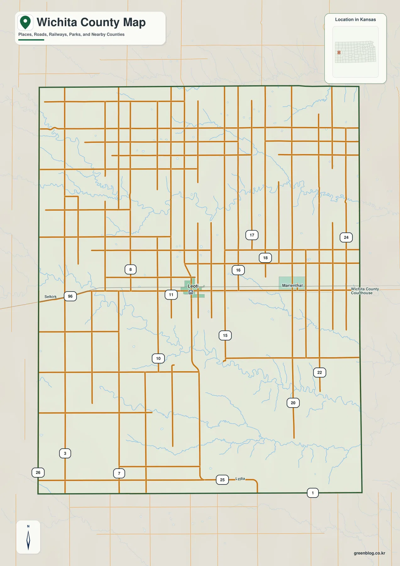
Marienthal appears east of Leoti, Selkirk provides a western reference, and Lydia lies near the southern side. Outside Leoti, the county is defined less by town-to-town development and more by broad agricultural sections crossed by roads and drainage channels.
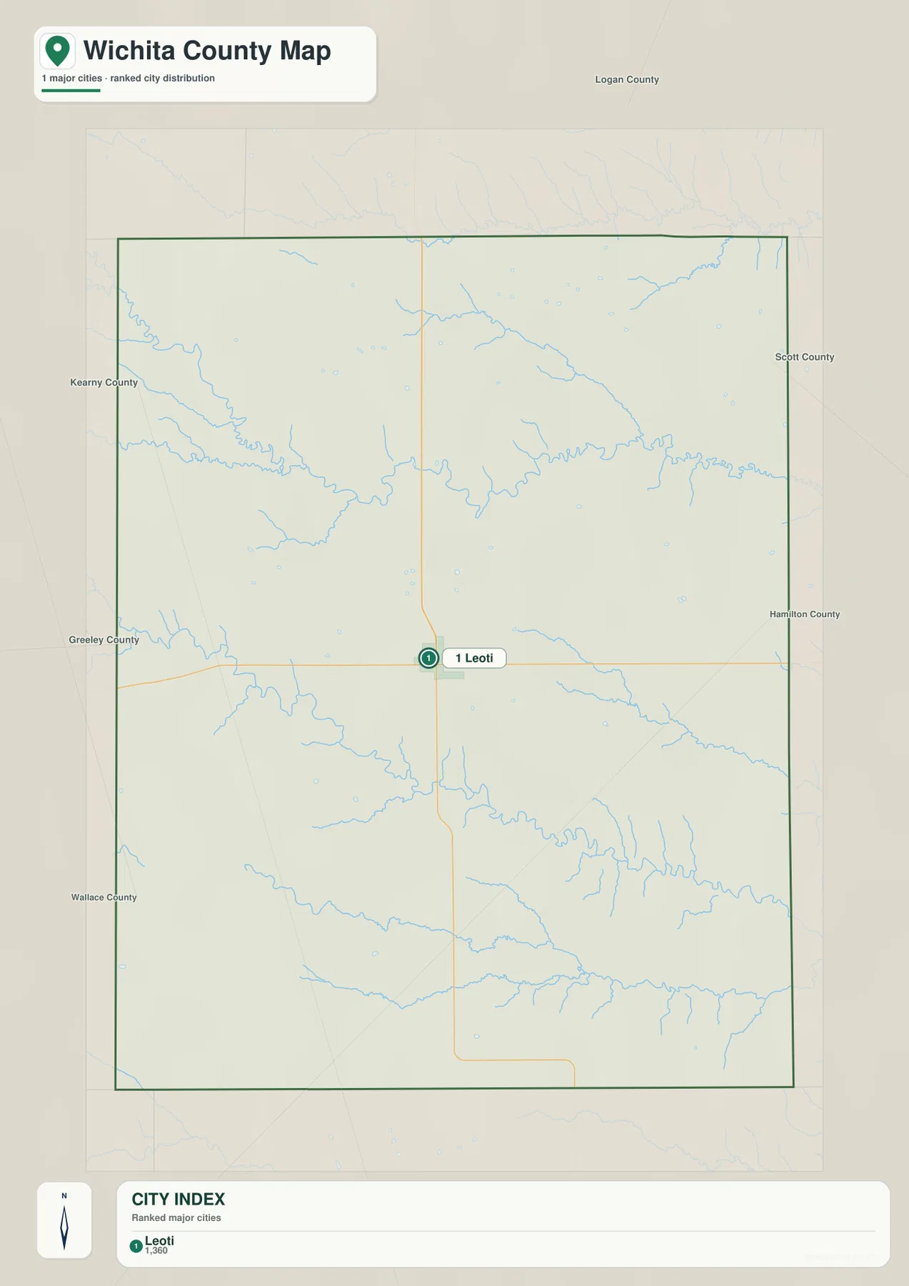
Leoti is the only community ranked on the city panel
The supplied city panel lists Leoti at an index value of 1,360. This is a map index rather than a current official population estimate. The lack of additional ranked cities reflects Wichita County’s highly concentrated settlement pattern, with one main town surrounded by extensive rural land.
That pattern means city size alone is not enough to understand the county. North and west of Leoti, short tributaries cut the higher plains, while White Woman Creek and Sand Creek form much longer low corridors across the southern half.
Kansas Historical Society census material also shows the county’s population concentrated in the Leoti area. The census count and the supplied city index are different datasets and should not be treated as interchangeable, but both reinforce Leoti’s role as the county’s principal community.
Ladder Creek, White Woman Creek, and Sand Creek divide the High Plains
Ladder Creek is the strongest northern drainage line on the water map. It enters from the west, bends through the north-central county, and continues east while collecting many short tributaries from the surrounding uplands.
White Woman Creek creates another long corridor across the south-central part of the county. Sand Creek runs farther south in a similar west-to-east direction. Together, these valleys divide the broad plains into several distinct bands of higher ground and lower drainage country.
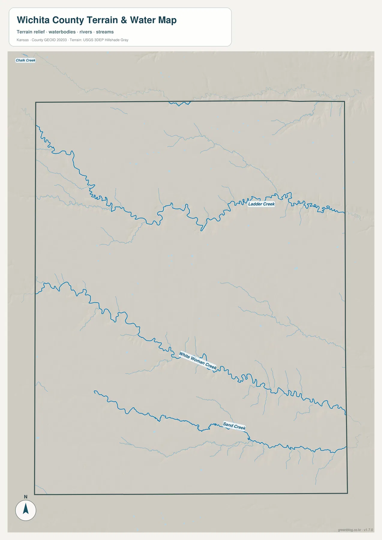
Chalk Creek appears beyond the northern edge of the map, but the three main internal systems are Ladder Creek, White Woman Creek, and Sand Creek. Wichita County lacks a dominant reservoir or large perennial river on this view, so smaller creeks provide the strongest natural framework.
This image is intended for geographic reference rather than floodplain, navigation, water-quality, parcel, or legal-access decisions. Flow in western Kansas creeks can vary with season and rainfall, so current conditions should be checked whenever access or safety depends on water level.
Elevation from 930 to 1,070 meters falls gradually from west to east
The elevation surface ranges from about 930 to 1,070 meters, with a mean near 1,005 meters. Brown and tan high ground dominates the western side, while greener lower terrain becomes more extensive toward the east. The Kansas Historical Society places Wichita County in the High Plains physiographic region, which fits this broad elevated surface.
The county is not simply a smooth tilted plain. Ladder Creek cuts a deep northern trough, while White Woman Creek and Sand Creek form long low corridors through the southern half. Short tributaries add local ridges and ravines even where the overall land surface looks gentle on the road map.
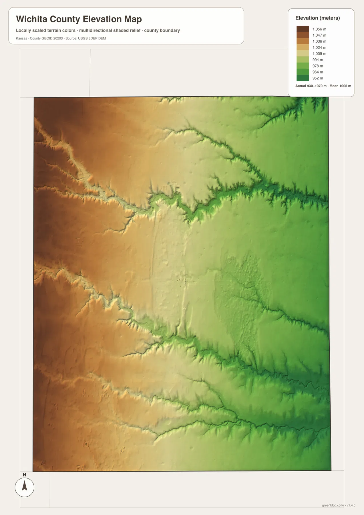
Leoti occupies intermediate terrain near the center of the county. Moving west toward the Greeley County side generally brings higher elevations, while the Scott County side and the major creek valleys sit lower. That gradual regional slope is one of the clearest patterns on the relief image.
The elevation surface is generalized for county-scale comparison. It is not survey-grade or engineering-grade measurement and should not be used for parcel elevations, construction grades, drainage design, or legal boundary work.
The Leoti–Coronado county-seat fight left an unusually dramatic local history
The Kansas Historical Society describes Wichita County’s early county-seat dispute between Leoti and Coronado as unusually intense. After the county was organized in 1886, the rivalry moved from competing newspapers and elections into violence, including a deadly 1887 confrontation in Coronado.
Leoti became the permanent county seat in 1887. The dispute continued briefly before Coronado declined after Leoti offered relocation lots to residents. The modern map, with Leoti as the only ranked city, looks very different from the period when two competing towns fought over the county’s administrative center.
Rare tipi-ring sites preserve evidence of earlier High Plains life
Kansas Historical Society material notes that stone tipi rings survive in unplowed pasture in Wichita County. The stones once helped hold down the edges of tipis used by Native families during hunting seasons, and repeated use left shallow depressions and archaeological evidence behind.
These sites add a much older layer of history to the modern agricultural landscape. Looking at the county’s broad open uplands makes it easier to understand why preserved pasture could retain features that would have disappeared under later cultivation.
The Museum of the Great Plains adds local history to the Leoti map
Travel Kansas describes the Museum of the Great Plains in Leoti as the Wichita County museum. Its collections cover the county-seat war, local fossil finds, cattle brands, saddles, military and Old West material, quilts, school history, and other community artifacts.
The museum gives map readers a local destination that connects the county’s modern center with its settlement history. The nearby Washington-Ames House adds another historic property in Leoti, while the museum itself provides a concise introduction to stories that are not visible on a road or terrain map.
The eastward route from Leoti follows a gradual drop across the plains
Traveling east from Leoti on K-96 toward the Scott County line looks nearly level on the road map, but the elevation surface shows a broad decline toward the eastern side. Ladder Creek and White Woman Creek cut additional low corridors into that regional slope.
Heading west from Leoti toward the Greeley County line shows the reverse pattern, with higher terrain becoming more dominant. Comparing the highway, water, and elevation views together makes the county’s west-to-east change much easier to see.
For posters, classroom prints, or presentation slides, use the original JPG files in the download archive rather than enlarging the web previews. Small road labels, place names, creek text, and the elevation legend remain clearer at the higher resolution.
Frequently Asked Questions
Why does the city map show only Leoti?
The supplied ranked-city dataset contains one Wichita County entry: Leoti at 1,360. Other place names can appear on the general county map, but they are not included in the city ranking panel.
How do Ladder Creek and White Woman Creek affect the terrain?
Both creeks cut long lower valleys into the High Plains. Ladder Creek dominates the northern half, while White Woman Creek crosses the south-central county and Sand Creek forms another long low corridor farther south.
Can the 930–1,070 meter elevation image be used for surveying?
No. It is a generalized county-scale terrain image for comparing higher western plains with lower creek valleys. Parcel elevations, engineering grades, drainage design, and legal boundary work require more precise official data and, where needed, professional surveying.
Map File Information
The archive contains the Wichita County, Kansas general county map, city map, terrain-and-water map, and elevation map as original high-resolution JPG files.
- Included Files: Use only the versions confirmed in the article and supplied images
- File Type: Use the confirmed download contents
- Intended Use: Printing, education, presentations, and map-based projects
Related Maps
Sources and references
- Wichita County, Kansas official website — county government and courthouse information in Leoti
- Kansas Historical Society: Wichita County, Kansas — county-seat war, tipi rings, High Plains setting, and local history
- Travel Kansas: Museum of the Great Plains — Leoti museum collections and local-history information
- U.S. Census Bureau TIGER/Line Shapefiles — county boundary and geographic reference data
- USGS National Hydrography — river and stream reference data
- USGS 3D Elevation Program — elevation and terrain reference data
Green Map creates custom-edited map images using open geographic data sources such as geoBoundaries, Natural Earth, OpenStreetMap, and government open data. These maps are edited visual materials, not raw data files, and are provided for education, documents, presentations, and graphic reference.