Washington County lies along the Nebraska border in north-central Kansas, with the city of Washington serving as the county seat and the clearest road reference. Hanover, Linn, Clifton, Greenleaf, and Barnes are scattered across a rural landscape rather than forming one continuous corridor. US 36 crosses the central-northern part of the county, K-15 approaches Washington from the south, and the Little Blue River creates a broad lowland along the eastern side. High-resolution map files are available for download in the section below.
This guide follows the county across the road, water, and elevation views, with terrain ranging from about 344 to 502 meters. Mill Creek cuts across the interior, the Little Blue River drains the east, and the western uplands rise well above the main valleys. WebP previews are available for quick viewing, and the matching high-resolution JPG files can be downloaded together in one ZIP for printing, classroom work, or offline reference.
Table of Contents
Washington anchors the US 36 and K-15 road network
The city of Washington sits near the center of the county where US 36 forms the main east–west route and K-15 arrives from the south through the Linn and Palmer side. Roads and rail lines concentrate around the county seat before spreading into a much sparser rural grid.
The Kansas Historical Society identifies Washington as the county seat. The present Washington County was established in 1857 and was named for George Washington. The modern map still shows the county seat in the most convenient central position for reaching the western towns, the eastern Little Blue country, and the southern K-15 corridor.
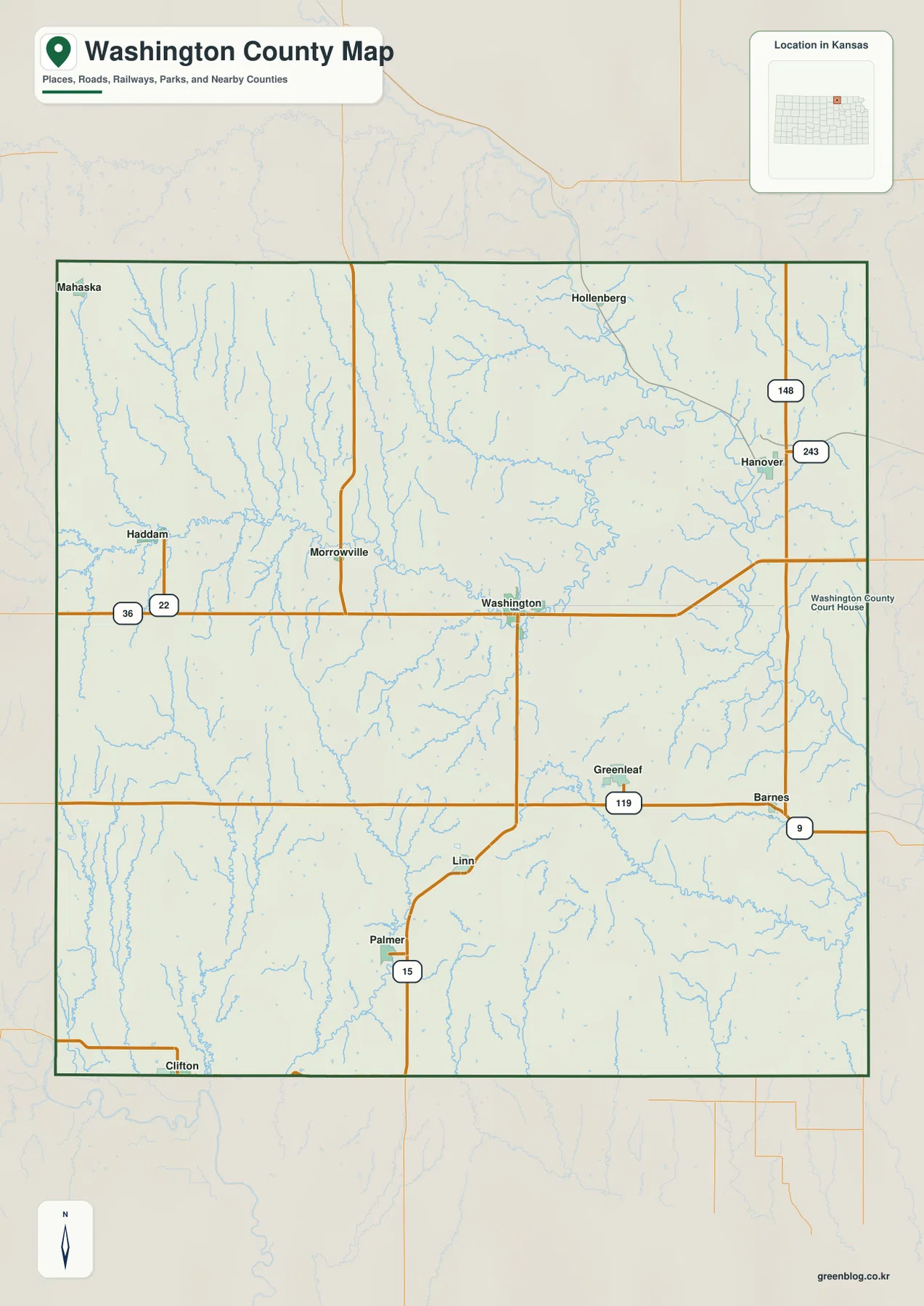
Hanover lies in the northeast near K-148 and K-243. Greenleaf and Barnes occupy the southeastern K-9 area, Linn sits south of Washington near K-15, and Clifton is close to the southwestern edge. Haddam and Morrowville provide additional western references, showing how widely the county’s small communities are distributed.
Washington leads a six-community city index
The supplied city panel ranks Washington at 1,155, Hanover at 828, Linn at 470, Clifton at 442, Greenleaf at 320, and Barnes at 177. These are map index values rather than current official population estimates, but they make the county’s settlement hierarchy easy to compare.
Washington and Hanover stand out as the two strongest references. Linn and Clifton serve the southern and southwestern countryside, while Greenleaf and Barnes occupy the southeastern side. Because each community sits in a different drainage setting, road and water context is more useful than city size alone.
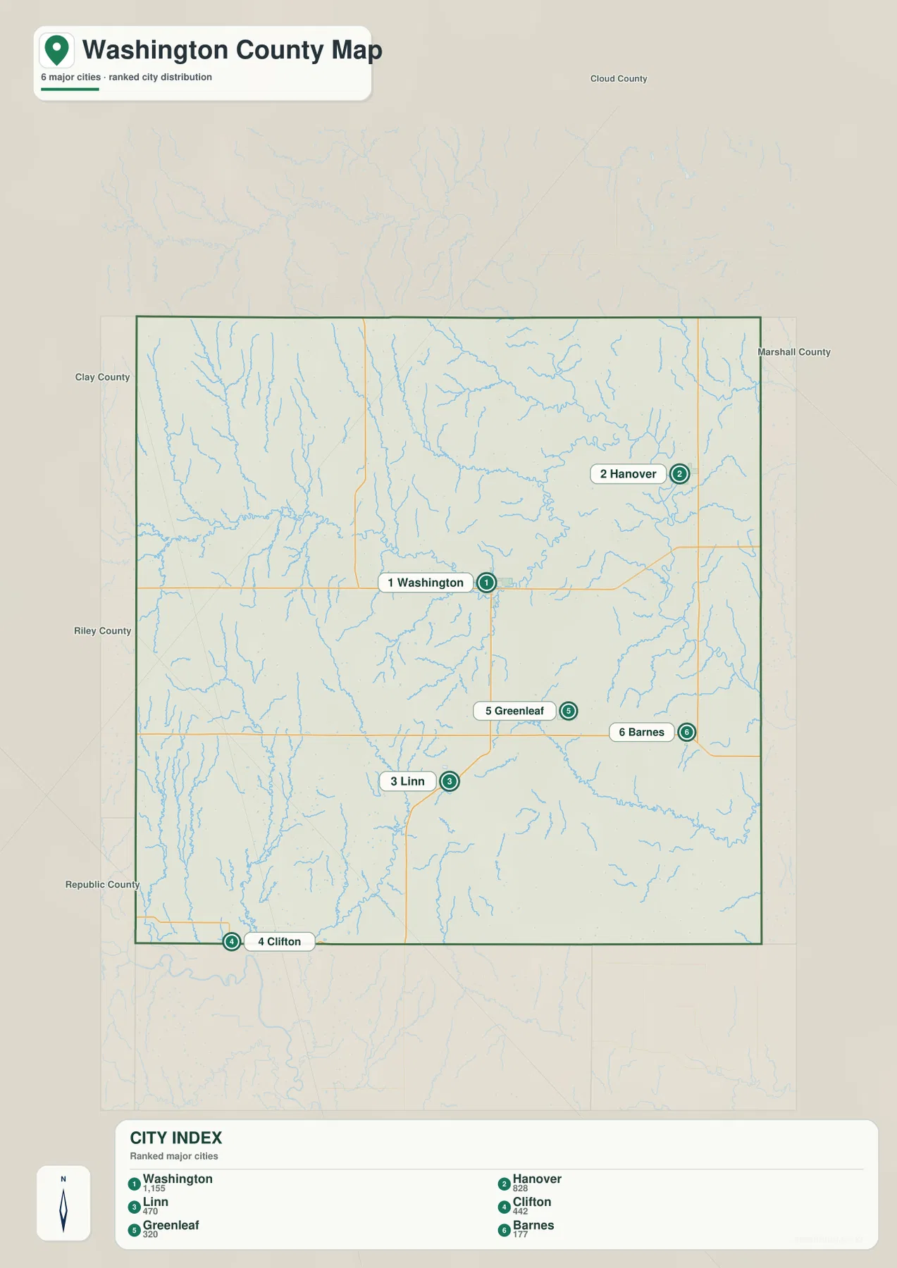
Kansas Historical Society census information also identifies Washington as the county’s largest city, with Hanover next. The official census counts and the supplied city index are different datasets and should not be used interchangeably, but both reflect the same broad pattern.
The Little Blue River and Mill Creek organize the county’s main lowlands
The Little Blue River is the strongest water feature on the eastern side. It runs through a broad, deeply incised valley near Hanover and the county boundary, collecting many short tributaries from the surrounding hills.
Across the interior, Mill Creek provides another long drainage corridor. Beaver Creek and Ash Creek cut the northwestern uplands, Riddle Creek and Devils Creek drain the north-central area, and Parsons Creek, Pete’s Creek, and Spring Creek divide the southern half.
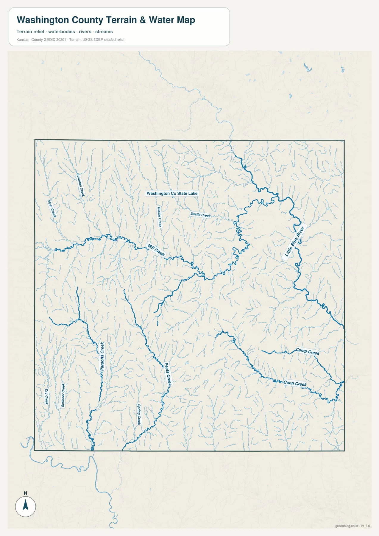
Coon Creek and Camp Creek form long southeastern valleys that trend toward the Little Blue system. North of the county center, the map labels Washington Co State Lake; the official Kansas Department of Wildlife and Parks name is Washington State Fishing Lake.
KDWP places Washington State Fishing Lake about 12 miles northwest of Washington. The agency describes a 65-acre lake surrounded by 352 acres of public wildlife land, making it a useful real-world reference for the north-central countryside as well as a fishing and wildlife area.
This image is intended for geographic reference rather than floodplain, navigation, water-quality, parcel, or legal-access decisions. Stream levels and lake conditions can change, so current agency information should be used whenever access or safety matters.
Elevation from 344 to 502 meters separates western uplands from the Little Blue valley
The elevation surface ranges from about 344 to 502 meters, with a mean near 423 meters. Brown and tan high ground dominates much of the northwest and west, while the Little Blue River corridor forms a broad green lowland along the eastern side.
Beaver Creek and nearby tributaries cut narrow green channels into the northwestern uplands. Mill Creek forms a lower cross-county corridor through the center, and Washington sits in an intermediate landscape of short ridges and creek bottoms.
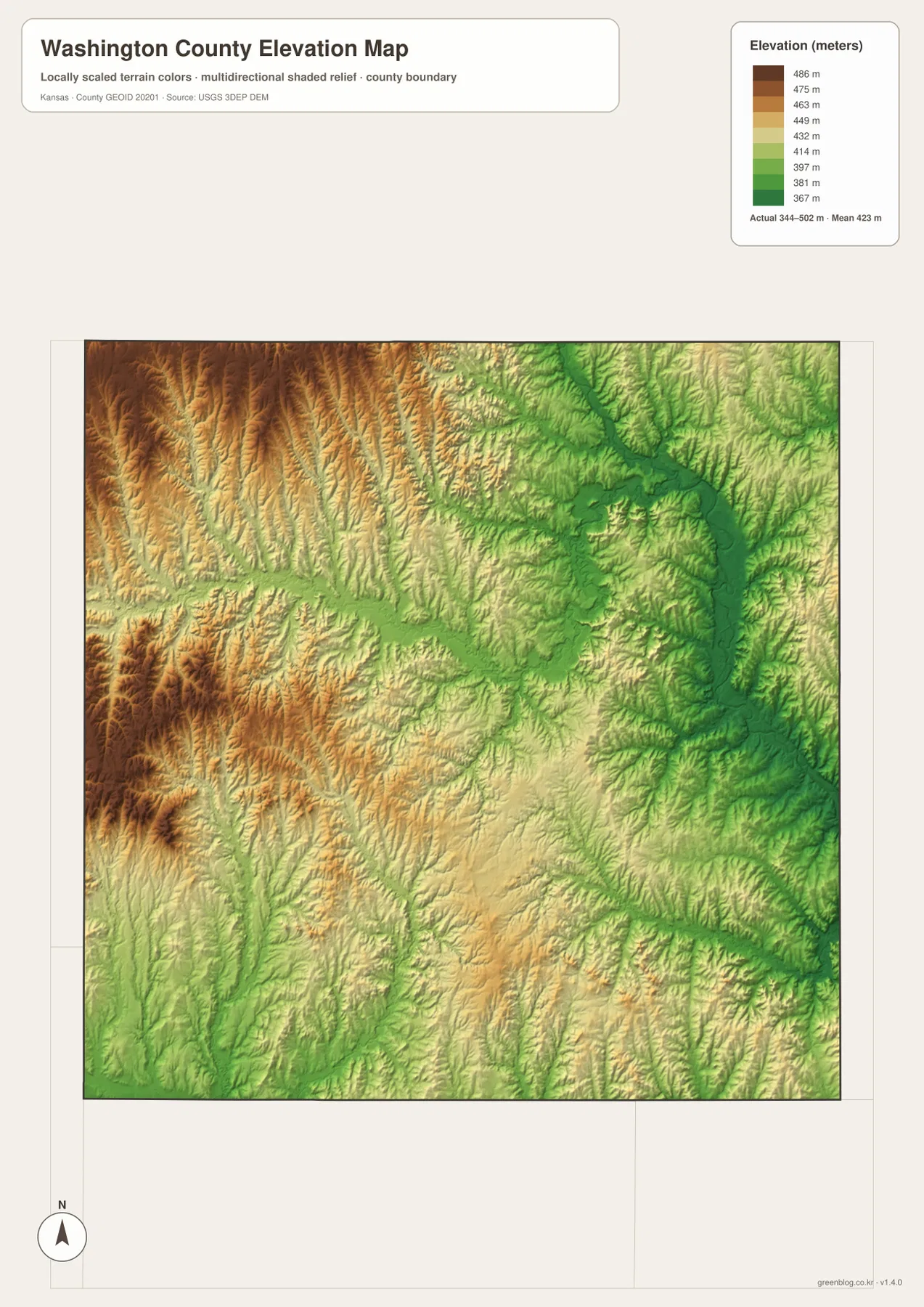
The Clifton side also contains pronounced western and southwestern relief, although Parsons Creek and Spring Creek divide the uplands into narrow ridges. Greenleaf and Barnes occupy generally lower southeastern terrain where Coon Creek and other tributaries approach the Little Blue system.
The elevation surface is generalized for county-scale comparison. It is not survey-grade or engineering-grade measurement and should not be used for parcel elevations, construction grades, drainage design, or legal boundary work.
Hollenberg Pony Express Station preserves an original trail stop near Hanover
One of Washington County’s most distinctive historic landmarks is Hollenberg Pony Express Station. The Kansas Historical Society records that Gerat and Sophia Hollenberg operated a road ranch at the site beginning in 1858, providing meals, supplies, lodging, animals, and wagon services to travelers.
The station later served the Pony Express in 1860 and 1861 and was also tied to the Oregon-California Trail. It is unusual because the historic station remains at its original location. The Kansas Historical Society manages it as a State Historic Site and National Historic Landmark.
On the county map, Hollenberg appears north of Hanover. The official site directions place it four miles north of US 36 on K-148 and one mile east on K-243. That road position, together with the Little Blue drainage nearby, gives modern visitors a useful sense of the terrain crossed by nineteenth-century travelers.
Hanover occupies a distinct eastern landscape beside the Little Blue system
Hanover is separated from Washington not only by distance but by terrain. K-148 and K-243 provide the main road references, while the Little Blue River and its tributaries create broader, lower valleys than those found across much of the western county.
Adding Hollenberg Station to the picture gives the northeast an unusually strong historical identity. The Nebraska border, Little Blue drainage, Pony Express history, and Oregon-California Trail connections all overlap in the same part of Washington County.
Traveling southeast from Washington reveals the shift from Mill Creek hills to lower river country
Heading from Washington toward Greenleaf and Barnes crosses the interior Mill Creek landscape before reaching lower southeastern terrain influenced by Coon Creek and the Little Blue drainage. K-119 and K-9 provide useful road references between the smaller communities.
Traveling west toward Clifton or northwest toward Haddam shows the opposite change. Elevation rises, ridges become more prominent, and tributaries carve narrower valleys. Comparing the road, water, and relief views together makes the county’s west-to-east contrast much clearer.
For posters, classroom prints, or presentation slides, use the original JPG files in the download archive rather than enlarging the web previews. Small highway shields, creek names, town labels, and the elevation legend remain clearer at the higher resolution.
Frequently Asked Questions
Which community is largest on the supplied city index?
Washington ranks first at 1,155. Hanover is 828, Linn 470, Clifton 442, Greenleaf 320, and Barnes 177. These are map index values rather than current official population estimates.
Where is Hollenberg Pony Express Station?
Hollenberg Station is north of Hanover. Kansas Historical Society directions place it four miles north of US 36 on K-148 and one mile east on K-243. The site preserves Pony Express and Oregon-California Trail history at its original location.
Can the 344–502 meter elevation image be used for surveying?
No. It is a generalized county-scale terrain image for comparing higher western hills with lower Little Blue River and creek valleys. Parcel elevations, engineering grades, drainage design, and legal boundary work require more precise official data and, where needed, professional surveying.
Map File Information
The archive contains the Washington County, Kansas general county map, city map, terrain-and-water map, and elevation map as original high-resolution JPG files.
- Included Files: Use only the versions confirmed in the article and supplied images
- File Type: Use the confirmed download contents
- Intended Use: Printing, education, presentations, and map-based projects
Related Maps
Sources and references
- Kansas Historical Society: Washington County, Kansas — county history, Hollenberg Station, and settlement background
- Kansas Historical Society: Hollenberg Pony Express Station — Pony Express, Oregon-California Trail, and historic-site information
- Kansas Department of Wildlife and Parks: Washington State Fishing Lake — lake location, size, and wildlife-area information
- U.S. Census Bureau TIGER/Line Shapefiles — county boundary and geographic reference data
- USGS National Hydrography — river and stream reference data
- USGS 3D Elevation Program — elevation and terrain reference data
Green Map creates custom-edited map images using open geographic data sources such as geoBoundaries, Natural Earth, OpenStreetMap, and government open data. These maps are edited visual materials, not raw data files, and are provided for education, documents, presentations, and graphic reference.