Monroe County in eastern Arkansas is easiest to understand by using Brinkley in the north and Clarendon in the southwest as two map anchors. Download the four high-resolution JPG maps on this page together in one ZIP file. The package includes the general county map, ranked city map, terrain and water map, and elevation map. Brinkley sits beside the I-40 corridor, while Clarendon—the county seat—lies along the White River near the mouth of the Cache River. Farther south, the county stretches through low agricultural country toward Indian Bay. The supplied elevation map ranges only from about 42 to 68 meters, showing just how flat most of Monroe County is.
Water shapes this county more strongly than mountains or major hills. The Encyclopedia of Arkansas notes that the White River separates Monroe County from Arkansas County and that the Cache River forms part of the boundary with Prairie County. Clarendon stands on the White River close to the Cache River confluence. On the supplied terrain and water map, the western side is filled with bends, old channels, lakes, and bayous, including the Cache River, Middle Old River, and Horseshoe Lake. The eastern half looks simpler on the road map but still contains a dense network of creeks and drainage lines.
Table of Contents
Follow I-40 at Brinkley, then Route 79 toward Clarendon
Brinkley is the clearest road reference in northern Monroe County. Interstate 40 runs east-west beside the city, and Route 70 approaches from the west. Route 38 reaches north toward Fargo, while Route 238 serves the low rural area east of Brinkley. Roads and small water channels are both concentrated around the northern section, so finding Brinkley first makes the rest of the long county easier to place.
South of Brinkley, the road network becomes more widely spaced. Route 241 crosses the central-eastern interior near the small community of Monroe, and Route 302 provides a useful reference toward the Clarendon side. Route 79 passes Clarendon near the White River. Farther south, Routes 86 and 33 help locate the Roe and Holly Grove area, while Routes 39, 49, 366, 146, and 17 extend through the eastern half. Route 1 appears near the narrow southern end close to Indian Bay.
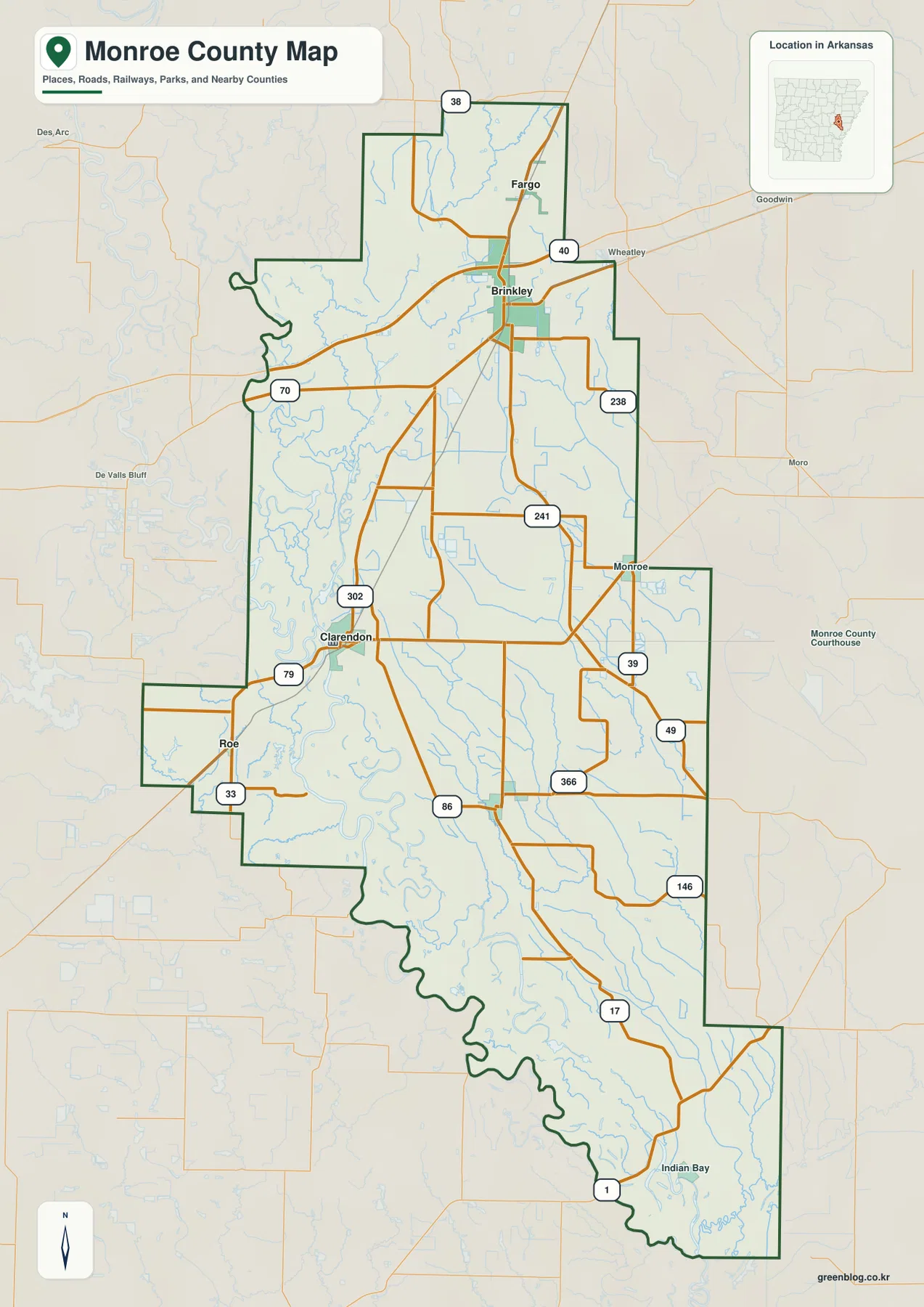
The county outline changes character from one side to another. Much of the western and southwestern boundary bends around river lowland rather than following long straight survey lines. The east includes longer straight and stair-step sections. Woodruff, Lee, Phillips, St. Francis, Arkansas, and Prairie counties are labeled around the map, placing Monroe County within the broad eastern Arkansas Delta between major river and agricultural landscapes.
The city ranking separates Brinkley, Clarendon, and the smaller southern communities
The city map ranks five major communities. Brinkley is number 1, Clarendon 2, Holly Grove 3, Roe 4, and Fargo 5. These numbers are ranking markers rather than distance measurements. Brinkley and Fargo occupy the northern section, Clarendon sits much farther southwest near the White River, and Holly Grove and Roe are in the lower half. The pattern shows a county with several separate small centers rather than one continuous urban corridor.
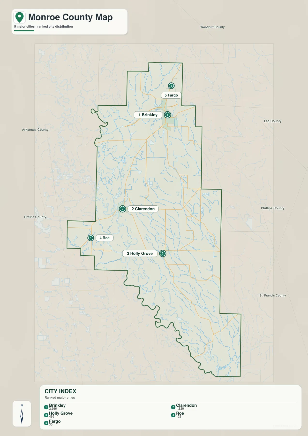
Brinkley and Clarendon play very different roles on the map. Brinkley is the largest ranked community and the strongest I-40 road center, but it is not the county seat. Clarendon holds that role, and the Monroe County Courthouse is located there. Its position near both the White River and the mouth of the Cache River makes Clarendon as important on the water map as it is on the administrative map.
Holly Grove and Roe provide useful reference points for the broad rural land south of Clarendon, while Fargo sits in the narrow northern extension above Brinkley. The city legend also includes numeric values next to the names, but this article does not reinterpret those figures as current population estimates. The map clearly supports the ranking and geographic position of the five communities; current population totals should be checked against recent Census data.
Cache River reaches the White River near Clarendon
The Cache River and White River are the most important western water references. The Cache River flows south through eastern Arkansas and enters the White River just east of Clarendon. On the supplied water map, the Cache River follows the western side through a complicated lowland of bends and secondary channels. Horseshoe Lake and Middle Old River appear nearby, reinforcing the impression of an active river plain rather than a simple straight boundary.
Farther north, Bayou de View runs through the northern interior, and Cutclotches Bay is visible outside the northwestern side. Lake Greenlee is labeled in the northeast, while East Lake appears farther south and west. Monroe County does not have one large inland reservoir dominating the page. Instead, the map combines major rivers, bayous, old channels, small lakes, and numerous shallow drainage features spread across a very flat landscape.
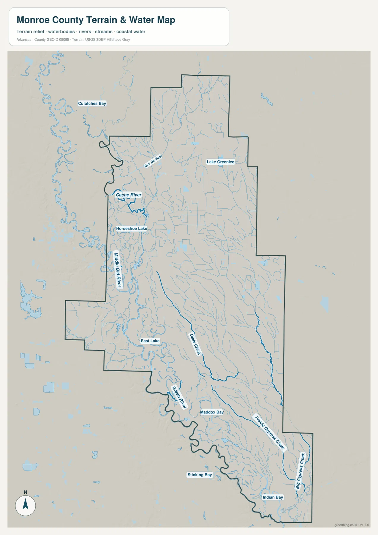
The southern half contains another set of long lowland waterways. Dial Creek curves through the middle and continues south, Prairie Cypress Creek follows the southeastern interior, and Big Cypress Creek is labeled near the far eastern edge. Maddox Bay and Stinking Bay appear farther southwest, with Indian Bay at the narrow southern end. Because the county has so little relief, these waterways can extend for long distances through gentle gradients rather than being confined to deep valleys.
The southeastern corner also has a distinctive regional landmark just beyond what is labeled on the supplied preview. Arkansas State Parks places Louisiana Purchase State Park at the junction of Lee, Monroe, and Phillips counties. The park preserves the initial survey point used for much of the Louisiana Purchase Territory and a remnant headwater swamp. That site is useful background for understanding the wet Delta setting near the Indian Bay end of Monroe County, but it should not be mistaken for a labeled attraction on this particular map image.
An elevation range of 42 to 68 meters means subtle differences matter
The supplied elevation map shows an actual range of about 42 to 68 meters, with a mean near 54 meters. That is only about 26 meters of total relief across the county. Most of the map appears green or light yellow-green, confirming that Monroe County is a very low Delta landscape. A narrow higher band stands out in the north-central section, and another elevated patch appears in the western projection near the Roe side, but neither should be interpreted as mountain terrain.
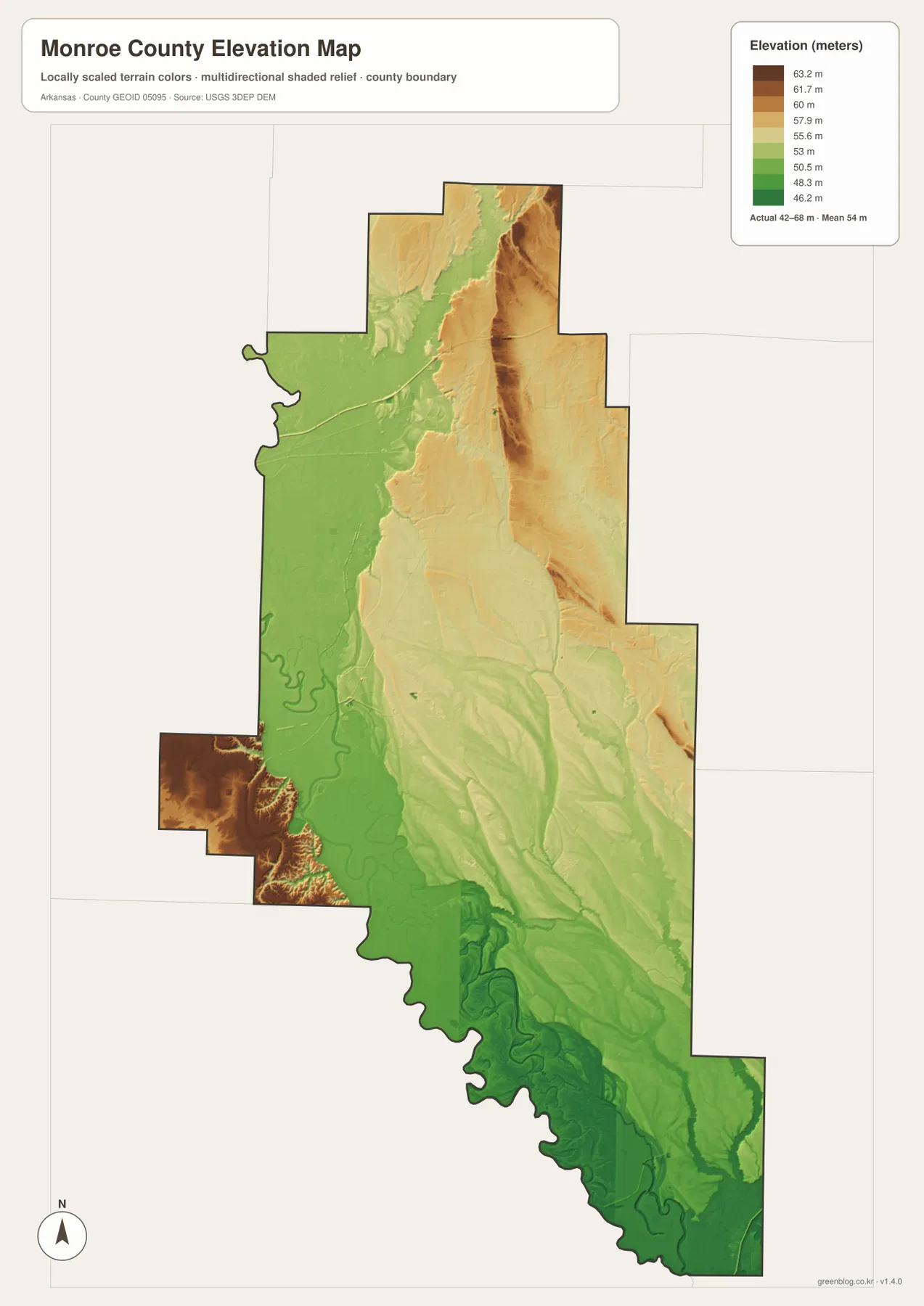
The Clarendon, Cache River, and White River side is generally among the lower green terrain. The same places that look crowded with river bends and old channels on the water map form a broad low surface on the elevation view. The southern Indian Bay area is also very low, with the shape of channels and former watercourses visible through subtle terrain shading. In a county this flat, differences of only a few meters can correspond with changes in drainage and the location of persistent wet areas.
The slightly higher north-central area extends around the Brinkley–Fargo side, and moderate elevation continues through portions of the eastern interior. The map alone does not justify naming every raised strip as a natural levee, dune, or specific geologic landform, so this article avoids those assumptions. What the supplied data clearly establishes is the small 42–68 meter range and the lower character of major river corridors. Exact field, levee, road, or building elevations require original USGS elevation data or survey-grade measurement.
Compare Brinkley, Clarendon, and Indian Bay to see the county change
A practical way to use all four maps is to begin at Brinkley, move southwest toward Clarendon, and then continue visually toward the Indian Bay end of the county. Around Brinkley, I-40 and Route 70 dominate the road view. Approaching Clarendon brings the Cache River, White River, Horseshoe Lake, and Middle Old River into focus, while the elevation colors become lower and greener. The map changes from a northern transportation center into a river-confluence landscape over a relatively short distance.
South of Clarendon, Holly Grove and Roe are useful settlement references, but waterways become increasingly important. Dial Creek, Prairie Cypress Creek, Big Cypress Creek, Maddox Bay, Stinking Bay, and Indian Bay spread across the low southern plain. The Lee–Monroe–Phillips county junction near Louisiana Purchase State Park adds another useful regional reference. Together, the maps show Monroe County as a sequence of distinct settings: the Brinkley road corridor, the Clarendon river junction, and the long southern Delta lowland.
The WebP images in the article are optimized for quick page viewing, while the download ZIP contains the same four maps as high-resolution JPG files. Each JPG measures 2572 × 3638 pixels in portrait orientation. Use the general map for Brinkley, Clarendon, roads, and county boundaries; the ranked city map for the five major communities; the terrain and water map for the Cache River, Bayou de View, Dial Creek, lakes, and bays; and the elevation map for the subtle 42–68 meter differences across the plain.
Frequently Asked Questions
Is Brinkley or Clarendon the county seat of Monroe County?
Clarendon is the county seat. Brinkley is ranked first on the supplied city map and is the stronger I-40 road center, but the Monroe County Courthouse is in Clarendon. Clarendon’s position on the White River near the Cache River mouth also makes it an important water-map reference.
How do the Cache River and White River connect near Clarendon?
The Cache River flows south along the western side of the county and enters the White River just east of Clarendon. Horseshoe Lake, Middle Old River, and other curved water features occupy the same lowland, so the relationship is much easier to see on the terrain and water map than on the road map alone.
What is most important about the Monroe County elevation map?
The actual range is only about 42–68 meters, with a mean near 54 meters. That small 26-meter difference confirms that Monroe County is overwhelmingly low and flat. The map is useful for comparing subtle higher strips with river lowlands rather than for finding major hills or mountains.
Map File Information
The ZIP contains the general county map, ranked city map, terrain and water map, and elevation map as high-resolution JPG files for printing or offline reference.
- File Type: ZIP containing 4 JPG files
Related Maps
Sources and references
- Encyclopedia of Arkansas – Monroe County – Clarendon county seat, White River and Cache River boundaries, and county geography
- Encyclopedia of Arkansas – Clarendon – Clarendon on the White River near the mouth of the Cache River
- Arkansas State Parks – Louisiana Purchase State Park – the Lee–Monroe–Phillips county junction, survey initial point, and Delta swamp setting
- U.S. Census Bureau TIGER/Line Shapefiles – county boundary and road data
- USGS National Hydrography – rivers, bayous, lakes, and hydrography data
- USGS 3D Elevation Program – elevation and terrain data
Green Map creates custom-edited map images using open geographic data sources such as geoBoundaries, Natural Earth, OpenStreetMap, and government open data.
These maps are edited visual materials, not raw data files, and are provided for education, documents, presentations, and graphic reference.