Download the high-resolution A3 JPG ZIP for this Henderson County Tennessee Map directly from this page; it includes the county, city, water, and elevation maps shown below. Lexington is the county seat and the main interior reference, Parker’s Crossroads sits to the north near I-40, Scotts Hill is southeast of Lexington, and Sardis lies farther south in the narrow lower extension of the county. Forked Deer tributaries shape the west, while Beech River and its lakes occupy a lower corridor on the east side.
Henderson County does not have one simple terrain direction. The elevation layer shows broad lower ground around the Beech River side, but higher rolling ridges appear across the northwest, north-central interior, and parts of the southwest. Roads and streams repeatedly use the lower gaps between those ridges, so Lexington’s road network makes more sense when the water and elevation maps are viewed alongside the base map.
Table of Contents
Lexington anchors three outer city references at very different distances
The city map ranks Lexington at 7,962 residents, Scotts Hill at 1,083, Parker’s Crossroads at 615, and Sardis at 536. Lexington is near the county’s center and serves as the most practical starting point. Parker’s Crossroads marks the northern side, Scotts Hill identifies the southeast, and Sardis lies even farther south where the county outline narrows.
The connector labels are straight-line distances rather than driving mileage. Lexington to Parker’s Crossroads is shown at about 7 miles, Lexington to Scotts Hill at about 13 miles, and Lexington to Sardis at about 17 miles. Those numbers are useful for scale and direction, but a road trip can be longer because the route must follow the actual highway network.
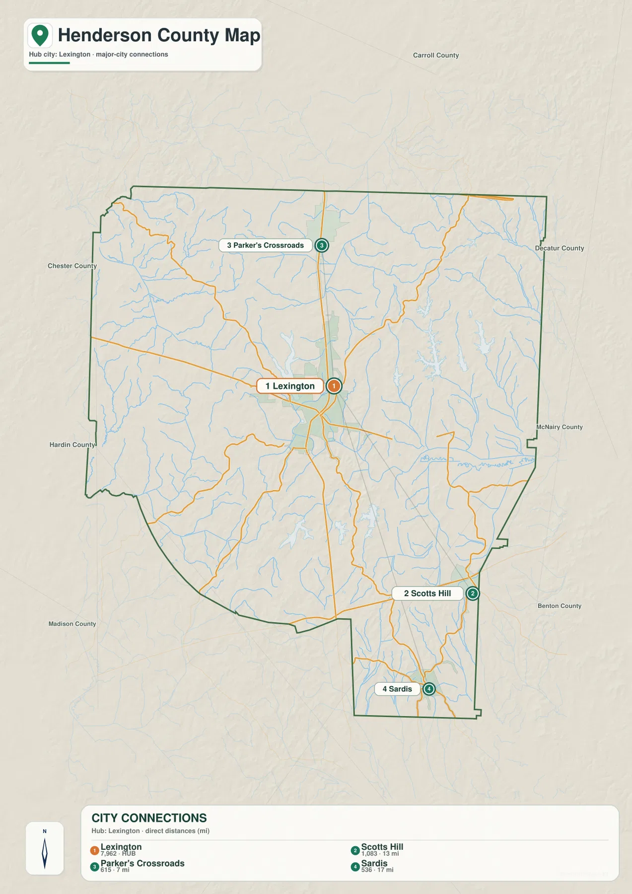
Carroll County appears to the north, Decatur County to the east, McNairy and Benton counties toward the southeast, Madison and Hardin counties along the west and southwest, and Chester County to the northwest. These outside labels help explain why Parker’s Crossroads is a northern gateway and why Scotts Hill and Sardis work better as southern references than as part of the Lexington core.
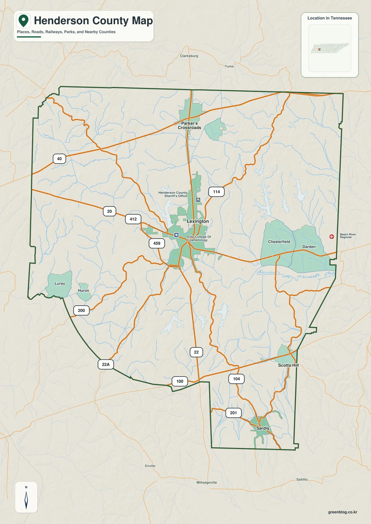
I-40 defines the north while Lexington distributes traffic across the county
I-40 crosses the northern side of the base map close to Parker’s Crossroads. Farther south, US 412 and Route 20 approach Lexington from the west, while Route 114 reaches the city from the northeast. Route 22 continues south through the interior, giving the map a strong north–south reference after the interstate corridor ends.
The southern road pattern changes as the county narrows. Route 100 crosses the lower half, Route 104 serves the Scotts Hill side, and Route 201 reaches the Sardis extension. Routes 22A and 200 appear in the southwest, while Route 459 is useful for locating the western side of Lexington. Taken together, the roads show a broad northern county feeding into a more constrained southern network.
Smaller place labels make the road map easier to use without adding every local street. Luray and Huron mark the southwest, while Chesterfield and Darden provide eastern references. Darden is especially useful when comparing the base map with the Beech River layer because the eastern roads approach a broad low drainage corridor rather than the higher ridges found farther north.
Forked Deer tributaries occupy the west, while Beech River defines the eastern lowland
The western water pattern is divided among several named channels. Cane Creek and Spencer Creek provide outer references, Middle Fork Forked Deer River crosses the northwest-to-west-central area, and North Fork Forked Deer River follows a lower corridor through the southwest. Big Sandy River creates another drainage in the north-central interior instead of merging every western valley into one single river system.
Beech River becomes the major reference on the east side. It follows a lower valley across the east-central county and continues toward Beech River Slough near the boundary. The elevation map shows this same corridor as broad green terrain, making the relationship between the river and the lower surface easy to recognize.
Several named lakes make the interior water map unusually useful for local orientation. Beech Lake sits northeast of Lexington, while Pin Oak Lake, Dogwood Lake, and Redbud Lake form a recognizable eastern group. Pine Lake, Sycamore Lake, and Lost Creek Lake are farther south. Rather than memorizing every water name, start with the two river systems and use the nearest lake as a local checkpoint.
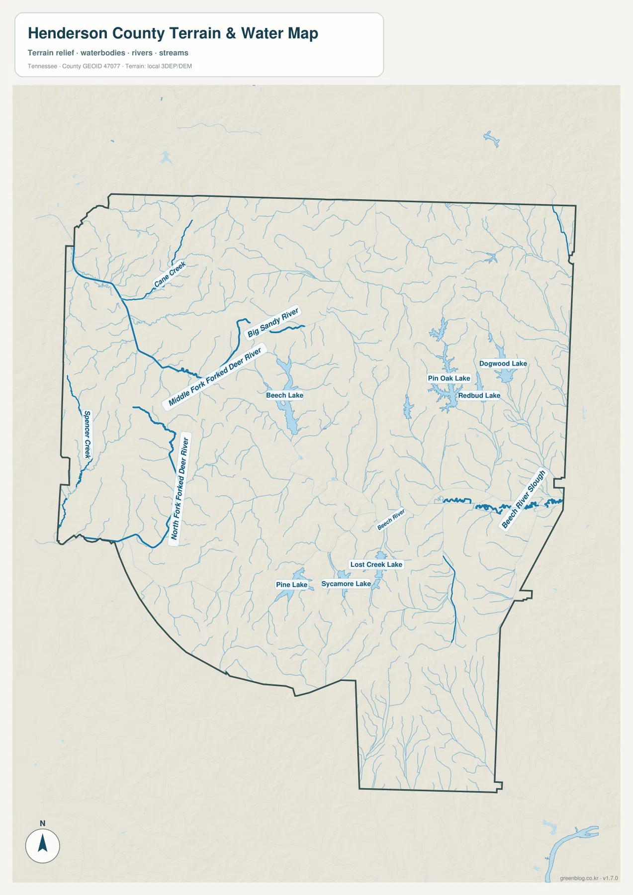
This page uses the water layer to compare river, creek, and lake positions within Henderson County. It should not be used to decide current flood conditions, boat access, shoreline ownership, or parcel limits. For those questions, a current agency source is necessary; here the map is most useful for seeing how Lexington, the road network, and the eastern and western drainage corridors fit together.
A 112–213 m range highlights the Beech River lowland and higher northern ridges
The elevation map shows an actual county range of about 112 to 213 meters, with a mean near 150 meters. Broad green low ground is concentrated across the eastern and southeastern Beech River corridor and in narrow stream valleys elsewhere. Higher tan and brown ridges are more common in the northwest and north-central county, with another elevated patch in the southwest.
The north is not a uniform flat interstate zone. Even around the I-40 side, short ridges and tributary valleys repeat across the surface. Moving south from Parker’s Crossroads toward Lexington, the relief becomes more mixed, and east of Lexington the terrain opens into the lower Beech River side. That change is visible even without a large mountain range because the local elevation colors shift across many small valleys.
The narrow southern extension toward Sardis also contains repeated ridges and stream cuts rather than one flat strip. Around Scotts Hill, Routes 100 and 104 cross rolling ground before reaching the more deeply incised eastern drainage. The useful countywide pattern is therefore a low eastern river corridor surrounded by multiple rolling uplands, not a simple slope in one compass direction.
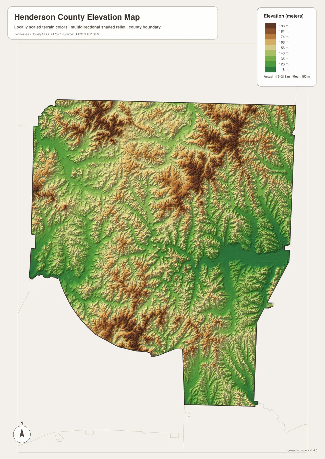
The elevation surface is intended to compare relative height across the county. It is not a surveyed elevation record for a specific property, but it clearly shows why Forked Deer and Beech River tributaries occupy green low corridors and why several roads curve through the gentler gaps between ridges.
Lexington links the interstate side, two drainage systems, and the southern extension
The city map establishes Lexington as the hub and gives Parker’s Crossroads, Scotts Hill, and Sardis clear directions and distances. The county map adds I-40, US 412, Route 22, and the southern road network. The water map then separates the western Forked Deer tributaries from the Beech River system on the east.
Elevation completes the picture. A trip north from Lexington approaches higher rolling terrain and the I-40 corridor, while an eastward look reaches the lower Beech River side. South toward Scotts Hill and Sardis, the county narrows and the road, creek, and ridge pattern becomes more tightly packed. These differences explain why each outer town is a useful reference for a different map-reading task.
Use the city layer for the straight-line distances, the base map for routes and smaller communities, the water layer for the Forked Deer and Beech systems, and the elevation image when the low eastern corridor versus higher rolling uplands is the main question.
Using the high-resolution A3 JPG files
The browser images are lightweight WebP previews. When road numbers, lake labels, or smaller tributaries need to remain legible on paper or a large screen, the JPG originals in the ZIP are the better choice. Use the base county map for route notes, the city layer for distance comparisons, and the water layer when Beech River or Forked Deer tributaries are the focus.
The elevation image benefits from color because the Beech River lowland and higher northern ridges are separated by terrain shading. At A3 size, the difference around Lexington, Parker’s Crossroads, and the southern extension is easier to compare without enlarging a small browser preview.
The ZIP below contains the high-resolution A3 JPG originals corresponding to the county, city, water, and elevation maps on this page. It is intended for printing, presentations, classroom use, offline reference, or any other situation where the map labels need more space than the embedded web images provide.
Frequently Asked Questions
Are the Lexington-to-city distance labels driving distances?
No. The city map uses straight-line distance. It shows roughly 7 miles from Lexington to Parker’s Crossroads, 13 miles to Scotts Hill, and 17 miles to Sardis, while actual driving mileage depends on the chosen road.
Where are Beech River and the Forked Deer branches on the map?
Beech River and Beech River Slough occupy the eastern lowland. Middle Fork and North Fork Forked Deer River are on the western and southwestern side, with Big Sandy River and smaller creeks dividing additional northern and western valleys.
Sources and reference data
For an official boundary reference, compare the county outline with U.S. Census Bureau TIGER/Line. Henderson County history and local reference material are available from the Tennessee State Library and Archives Henderson County fact sheet, and the road network can be compared with the Tennessee Department of Transportation Henderson County map.
For water features, USGS National Hydrography provides the broader hydrographic reference, while the USGS 3D Elevation Program is the official elevation source to compare with the relief layer. The descriptions here stay within the roads, place labels, water features, and height differences visible in the supplied Henderson County maps.
Map File Information
The Henderson County archive includes the high-resolution A3 JPG originals for the four map views used in this article.
- Included Files: County map, city map, water map, elevation map
- File Type: ZIP containing 4 JPG files
Related Maps
- Alamo to Gadsden: A Crockett County Tennessee Map
- Altamont, Monteagle, and Plateau Valleys — Grundy County Tennessee Map
- Around Chattanooga: Hamilton County Tennessee Map
Green Map creates custom-edited map images using open geographic data sources such as geoBoundaries, Natural Earth, OpenStreetMap, and government open data. These maps are edited visual materials, not raw data files, and are provided for education, documents, presentations, and graphic reference.