Download the high-resolution A3 JPG ZIP for this Henry County Tennessee Map directly from the page; it includes the county, city, water, and elevation maps shown below. Paris is the county seat and the main road hub, with Puryear to the north, Cottage Grove to the northwest, and Henry to the southwest. Kentucky Lake dominates the eastern side, while Obion and Blood river branches cross the inland half of the county.
The county makes the most sense when Paris and Kentucky Lake are used as opposite anchors. Around Paris, roads spread toward the smaller communities and county edges. Eastward, the shoreline becomes the stronger reference as long reservoir arms occupy low valleys. North and west of Paris, rolling uplands are broken by the North and Middle Forks of the Obion River and by the Clarks and Blood river branches.
Table of Contents
Paris anchors three simple straight-line city connections
The city map labels Paris at 10,338 residents. Puryear is shown at 736, Henry at 534, and Cottage Grove at 60. The ranking is less important than the direction of each place: Puryear is north of Paris, Henry is southwest, and Cottage Grove is northwest. That gives the map three useful outer references before the road network is added.
The connector labels are straight-line distances rather than driving mileage. Paris to Puryear is shown at about 10 miles, Paris to Henry at about 9 miles, and Paris to Cottage Grove at about 11 miles. Those numbers provide a quick sense of scale, but the actual road distance depends on which route is used and how the local roads bend around streams and rolling ground.
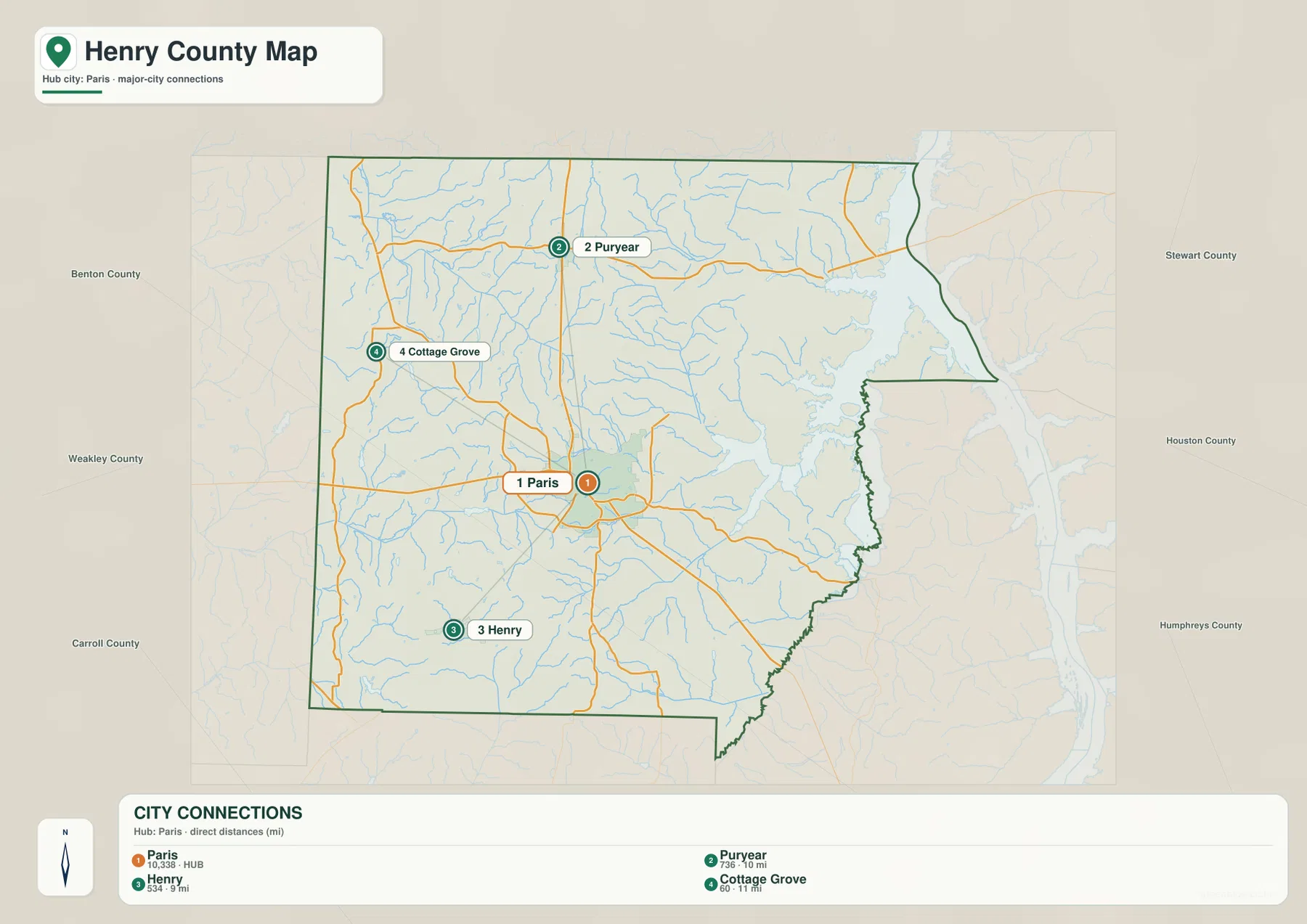
Benton, Weakley, and Carroll counties appear to the west and southwest, while Stewart, Houston, and Humphreys counties are labeled on the eastern side of the map. The eastern outline is especially irregular because broad reservoir water occupies that side. These outside labels are useful for general orientation, but Paris remains the clearest internal reference.
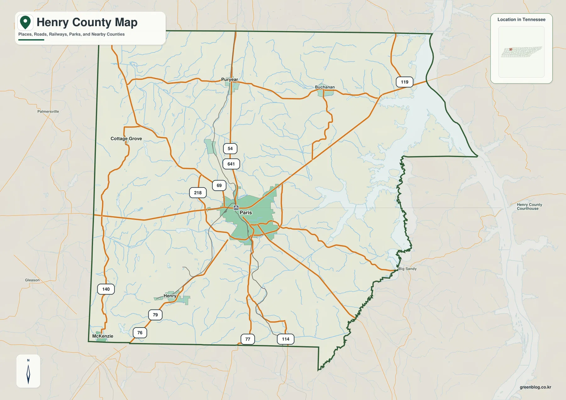
Roads converge on Paris, then separate toward Puryear, Henry, and Buchanan
Routes 54, 641, 69, and 218 are clustered around the Paris area on the base map. Routes 54 and 641 are useful for locating the northern approach toward Puryear, while Route 69 provides a strong north–south reference through the central county. Route 218 extends toward the western and northwestern side.
The southwestern half uses another set of road markers. Routes 79 and 76 help locate the Henry and McKenzie side, while Routes 77 and 114 appear close to the southern boundary. In the northeast, Route 119 is the clearest numbered reference near Buchanan. Eastbound roads approaching Kentucky Lake are shaped by narrow reservoir arms and creek valleys, so they do not resemble the broader inland road pattern.
A practical way to use the road map is to begin with Paris and one destination. For Puryear, look first at Routes 54 and 641. For Henry, shift to the 79 and 76 side. For Buchanan, Route 119 provides the quickest orientation. This keeps the road network readable while still showing how the county connects to the lake shore and outer communities.
Kentucky Lake dominates the east, while Obion and Blood branches drain the interior
The broad water body on the eastern edge is the strongest feature on the supplied water map. Kentucky Lake reaches into the county through long bays and low valleys, giving the eastern boundary a deeply indented shape. Near the southeast, the Big Sandy River Dewatering Area is labeled close to the water, with West Sandy Creek extending inland from the same general side.
The northern and western drainages point in different directions. North Fork Obion River crosses the northwestern interior, and Middle Fork Obion River runs through the central-western side. Farther north, Left Fork Clarks River, Middle Fork Blood River, and Blood River occupy separate valleys. These channels show that Henry County is divided between the large reservoir edge and several inland drainage systems.
Named lakes provide smaller reference points between those river systems. Briarpatch Lake, Jones Bend Lake, Smith Lake, and Green Acres Lake are scattered across the central and western half, while Weaks Lake is farther east. Beaverdam Lake and a labeled Drainage Canal appear in the south. These features help locate inland areas that are far from the Kentucky Lake shoreline.
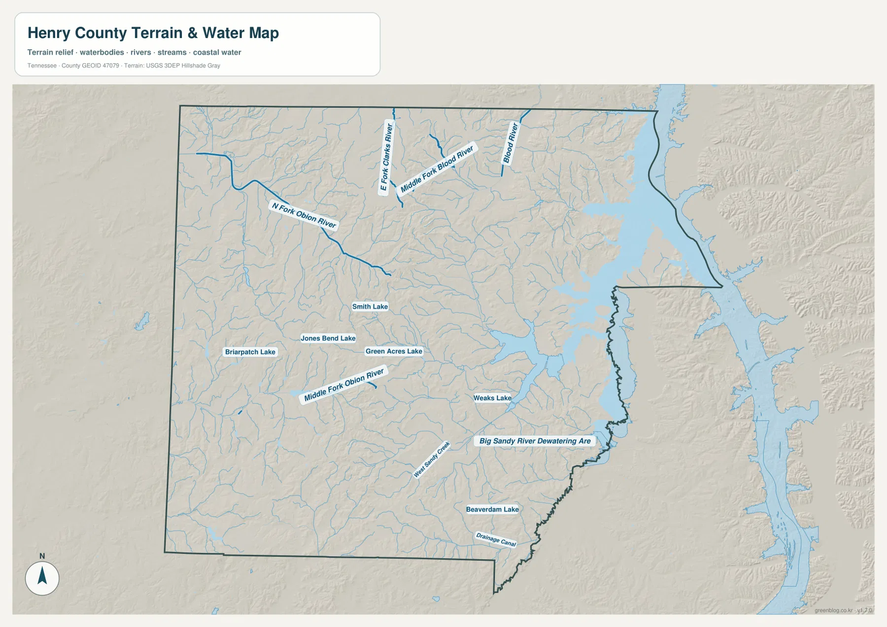
The water layer is best used for geographic reference within Henry County. Reservoir level, shoreline access, and boating conditions can change, and this page does not replace current operating or safety information. Its value here is showing how Paris and the road network sit between the inland streams and the much larger Kentucky Lake system.
A 107–198 m range separates low lake valleys from higher inland hills
The elevation map shows an actual range of about 107 to 198 meters, with a mean near 143 meters. Darker green low ground is concentrated along Kentucky Lake, reservoir arms, and stream valleys. Higher tan and brown terrain is more common in the northwestern and west-central interior, where short ridges form a rolling surface away from the main lake shore.
The north-central area contains some of the broadest higher ground. Low valleys linked with the Clarks and Blood river branches cut into those uplands, leaving ridges between the drainage lines. The western side also contains repeated short hills and creek valleys rather than one flat surface. Paris occupies intermediate terrain where several of these local corridors meet.
Eastward, the landscape drops into wider green zones around Kentucky Lake and the Big Sandy side. Low reservoir valleys reach well inland, but short rises return between the bays. Henry County is not mountainous, yet the roughly 90-meter countywide range is enough to make the lake shore, creek bottoms, and inland uplands visually distinct on the same map.
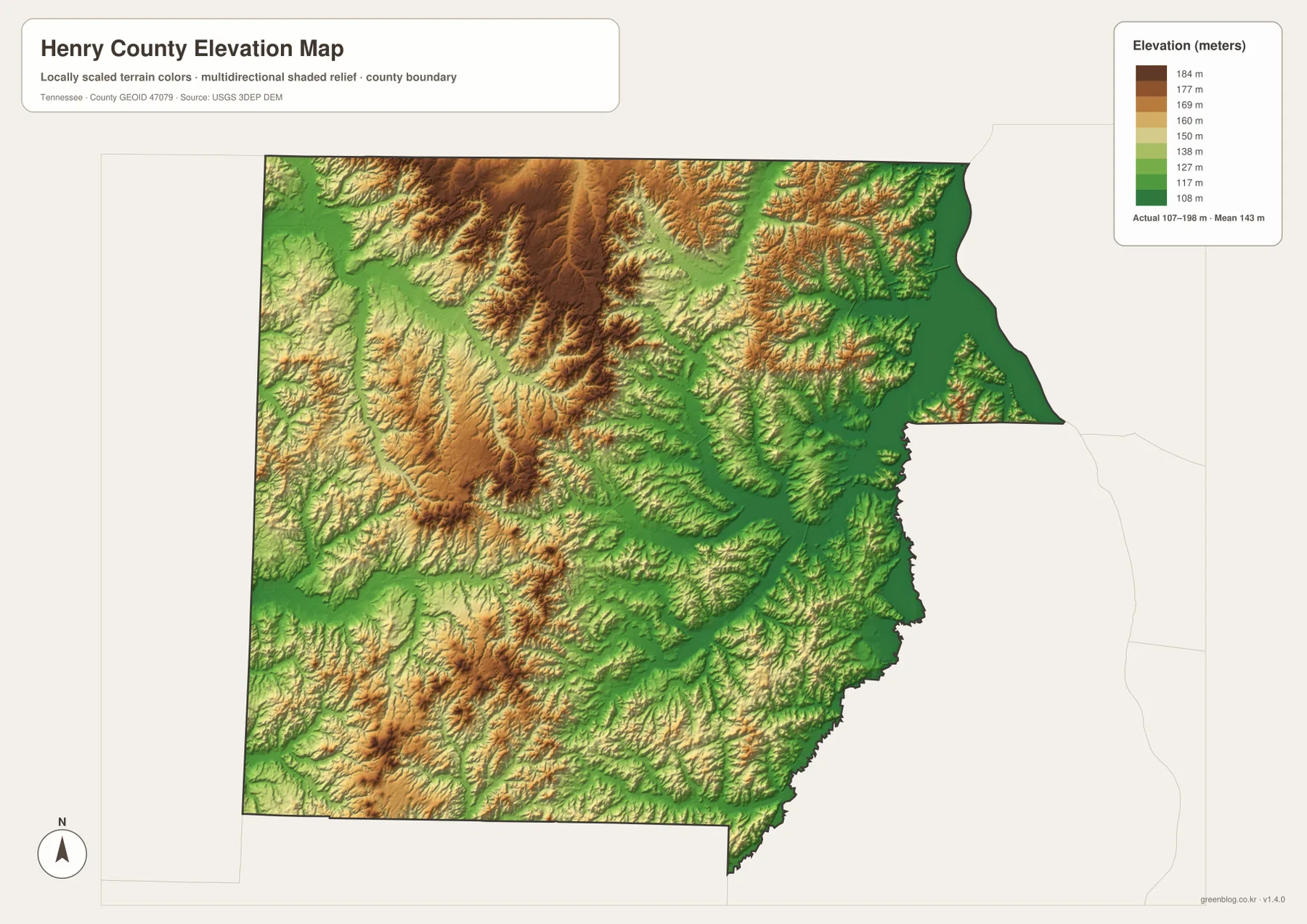
This elevation surface is useful for county-scale comparison rather than a precise elevation at a house or parcel. It clearly shows the drop from the inland hills toward the reservoir edge and helps match many creek valleys with the lower green corridors seen between the ridges.
Paris and Kentucky Lake provide two anchors for reading the whole county
The city map establishes the Paris-centered relationship with Puryear, Henry, and Cottage Grove. The base map adds the route network, while the water map explains why the eastern road pattern becomes more irregular near Kentucky Lake. The inland Obion and Blood branches create another set of valleys to the north and west.
The elevation map ties those features together. The lake side and stream bottoms sit lower, while the northwestern and west-central interior rises into broader rolling uplands. As a result, a trip from Paris toward Kentucky Lake crosses a different landscape from a trip toward Cottage Grove or Puryear, even though all three begin from the same hub city.
Use the city map for straight-line distances and town positions, the county map for roads and smaller place labels, the water map for Kentucky Lake and the inland drainage systems, and the elevation map when the difference between low shorelines and inland hills is the main question.
A3 JPG files for printing and closer map work
The WebP previews are sized for reading in the browser. The JPG originals in the ZIP provide more room for printed notes and larger display. If the task is route-oriented, keep Paris and the needed destination on the county map; if the task is to compare the smaller communities, use the city layer with its straight-line connectors.
The water JPG is the better choice when the Kentucky Lake shoreline, Obion branches, Blood River, or West Sandy Creek is the main subject. The elevation image works best in color because the low reservoir valleys and higher inland ground are separated by terrain shading. At A3 size, the smaller lake labels and route numbers are easier to read than in the page preview.
The ZIP below packages the A3 JPG originals used to compare Paris, the Kentucky Lake shoreline, inland waterways, and Henry County terrain. They are suitable for classroom comparison, presentations, route notes, regional study, and offline reference when the browser images are too small for the job.
Frequently Asked Questions
What do the Paris-to-community distance labels mean?
The city map uses straight-line distance rather than driving mileage. Paris to Puryear is shown at about 10 miles, Paris to Henry at about 9 miles, and Paris to Cottage Grove at about 11 miles, so actual road trips can be longer.
How does Kentucky Lake differ from the inland river system?
Kentucky Lake is the broad water body along the eastern edge. North and Middle Fork Obion River occupy inland western areas, while the Clarks and Blood river branches are farther north. The water map makes those separate drainage areas easy to compare.
Sources and reference data
County history and local reference material are available from the Tennessee State Library and Archives Henry County fact sheet. Official Kentucky Reservoir information is available from the Tennessee Wildlife Resources Agency, and county boundary data can be compared with U.S. Census Bureau TIGER/Line.
For additional hydrography reference, see USGS National Hydrography. Elevation data can be compared with the USGS 3D Elevation Program. The descriptions in this article follow the places, roads, water features, and elevation differences visible in the supplied Henry County maps.
Map File Information
The archive contains the A3 high-resolution JPG originals for the Henry County county, city, water, and elevation maps used on this page.
- Included Files: County map, city map, water map, elevation map
- File Type: ZIP containing 4 JPG files
Related Maps
- Clay County Tennessee Map
- Humphreys County Tennessee map
- Parsons, Kentucky Lake, and the River Edge — Decatur County Tennessee Map
Green Map creates custom-edited map images using open geographic data sources such as geoBoundaries, Natural Earth, OpenStreetMap, and government open data. These maps are edited visual materials, not raw data files, and are provided for education, documents, presentations, and graphic reference.