Wake County is one of the most urbanized parts of central North Carolina, but the map is much easier to understand when Raleigh is treated as one major center rather than the only center. Cary and Morrisville form a dense western urban area, Apex and Holly Springs extend the southwest, Wake Forest and Rolesville define a separate northern direction, and Knightdale, Wendell, and Zebulon spread east of Raleigh. Fuquay-Varina adds another strong southern reference.
This page combines a road-and-place map, a ranked six-city distribution map, and a terrain-and-water view centered on Falls Lake, Neuse River, and the county’s network of creeks and small lakes. The WebP previews are designed for quick browsing, while the download box below provides three matching high-resolution A3 JPG files in one ZIP. The larger files are better when road shields, smaller stream labels, or the detailed shoreline of Falls Lake need to be enlarged or printed.
Table of Contents
Wake County quick facts
- County seat: Raleigh
- Ranked city map: Raleigh, Cary, Apex, Wake Forest, Holly Springs, Fuquay-Varina
- Other visible place references include Morrisville, Rolesville, Knightdale, Garner, Wendell, and Zebulon
- Major numbered roads visible on the general map include 540, 264, 64, 87, and 70
- Named water features include Falls Lake, Neuse River, Crabtree Creek, Walnut Creek, Buffalo Creek, Little River, White Oak Creek, and Middle Creek
- Smaller water references include Lake Crabtree, Lake Johnson, Lake Wheeler, Lake Benson, and Shearon Harris Reservoir
The existing page frames Wake County as a core Research Triangle county that grew into a large metropolitan area. This rewrite keeps that broad context but anchors the detailed discussion in what the supplied maps actually show: the separate Raleigh, Cary, Wake Forest, Apex, and southern-town directions, together with Falls Lake and the Neuse River system.
Raleigh is not the whole metro county
Raleigh is the largest and most obvious starting point on the general map. The developed area occupies a broad central section, the Wake County Courthouse is labeled near the city core, and route 540 forms a large orbital reference around the northern and western sides. Even so, the urban footprint does not stop at Raleigh’s edge, and several other places remain strong enough to organize their own parts of the county.
Cary is the clearest western counterpoint. Its developed area nearly meets Raleigh, while Morrisville sits farther northwest and Apex extends the corridor toward the southwest. Holly Springs is farther south again. If all of these places are described only as Raleigh suburbs, the map loses useful directional information about where western and southwestern growth is concentrated.
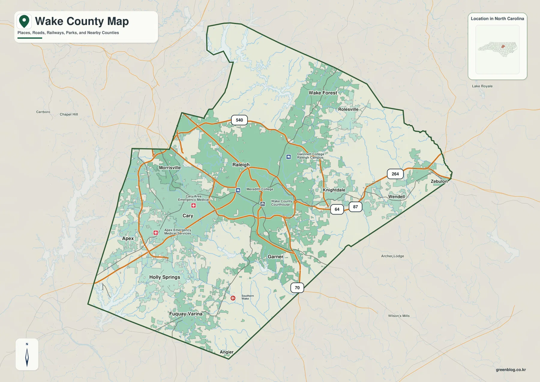
South of Raleigh, Garner provides the nearest separate urban reference, while Holly Springs and Fuquay-Varina create a more distant southern and southwestern cluster. Angier is visible below the county as outside context. The county boundary should be checked carefully in this area so nearby places outside Wake County are not mixed with internal communities.
The east is less continuous than the west. Knightdale sits close to Raleigh, but Wendell and Zebulon are farther out with larger open areas between them. Routes 64, 264, and 87 help organize this direction. The result is a metropolitan county with several distinct corridors rather than one uniformly built-up surface.
Cary and Wake Forest form separate growth axes
The ranked city map simplifies the settlement pattern. Raleigh is first at 481,031, Cary second at 179,306, and Apex third at 70,630. Wake Forest is fourth at 52,844, Holly Springs fifth at 45,248, and Fuquay-Varina sixth at 40,485. These are values printed on the supplied graphic and are not being presented as independently updated population estimates.
Location adds more meaning than rank alone. Cary sits directly west of Raleigh and Apex continues the broader western-southwestern corridor. Wake Forest is much farther north and closer to the Falls Lake side, making it a separate growth direction rather than another western suburb. This distinction matters because the northern county has a different water-and-open-space frame around it.
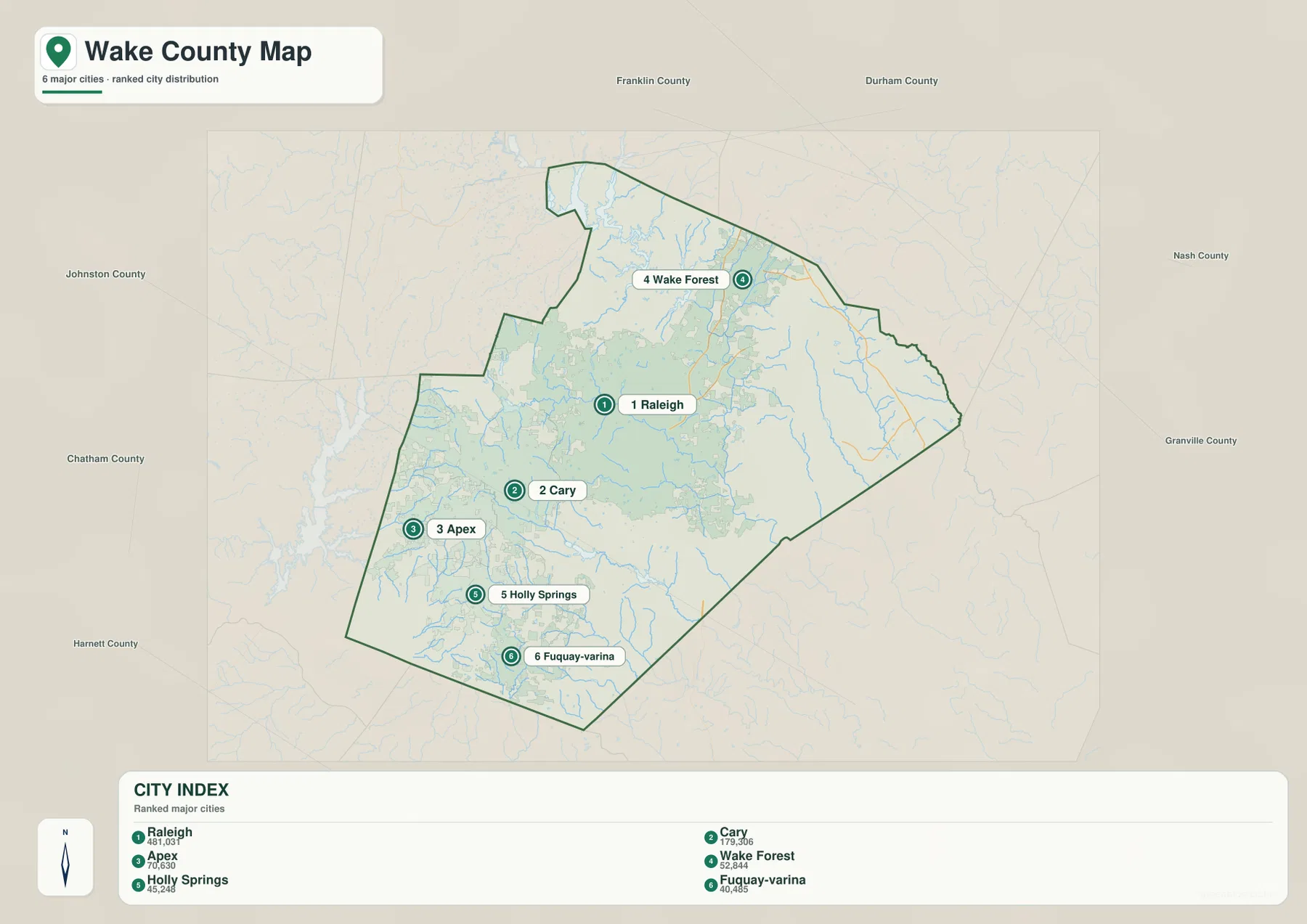
Holly Springs and Fuquay-Varina create their own southern concentration. Both are well away from the Raleigh core on the city map, and their position gives the southern county a clear settlement axis. Keeping this cluster separate from Cary and Apex prevents the southwest and south from being compressed into one vague outer-suburb label.
The outer map labels Durham, Franklin, Johnston, Chatham, Harnett, Nash, and Granville counties. These are regional references rather than measurements of travel time or legal distance. They help show how Wake County sits between the Research Triangle core and lower-density neighboring counties.
Falls Lake and the Neuse provide the physical frame
Falls Lake is the strongest northern water reference on the terrain map. Its irregular shoreline occupies the upper county and receives numerous small tributaries. Wake Forest sits relatively close to this system, so the northern growth area is best understood together with the reservoir and stream network rather than as urban expansion alone.
Neuse River leaves the Falls Lake area and runs through the central-eastern county toward the southeast. It provides a stable physical reference east of Raleigh and near the Knightdale direction. Walnut Creek and Buffalo Creek connect into this broader drainage network, showing how urban areas are crossed by stream valleys that do not follow municipal boundaries.
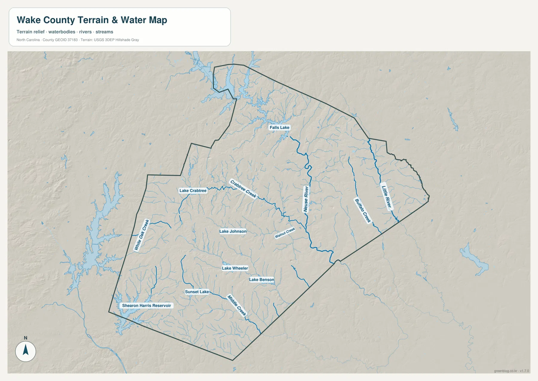
The western side has its own water references. Crabtree Creek and Lake Crabtree help organize the Cary-Morrisville area, while Lake Johnson appears southwest of Raleigh. Lake Wheeler and Lake Benson sit farther south, and Shearon Harris Reservoir provides a large southwestern reference near the county edge. These features make the western and southern metro area easier to separate into smaller local settings.
Little River appears in the east, White Oak Creek in the west-southwest, and Middle Creek farther south. Relief is gentle compared with western North Carolina but not perfectly flat; low Piedmont ridges and stream valleys repeat between developed areas. The terrain-and-water map is intended for general orientation, not flood determination, water depth, parcel boundaries, or survey-grade elevation.
Using multiple centers in a metropolitan county
A practical reading order starts with Raleigh, then separates Cary-Apex to the west and southwest, Wake Forest-Falls Lake to the north, Holly Springs-Fuquay-Varina to the south, and Knightdale-Wendell-Zebulon to the east. Adding Neuse River and Crabtree Creek then shows how natural drainage cuts across those settlement corridors rather than matching city boundaries exactly.
The general map is the strongest choice when road numbers and named places matter. The city map makes relative settlement scale and distribution easier to compare. For Falls Lake, Neuse River, creek valleys, and smaller lakes, the terrain-and-water map carries more useful detail. Switching views by question is a better way to understand a complex metropolitan county than forcing all information into one map.
The download archive contains three high-resolution A3 JPG files matching the Wake County general map, city-distribution map, and terrain-and-water map. The WebP previews keep the page lighter, while the JPG originals are better for printing, enlargement, and document placement, especially around small stream labels and the detailed Falls Lake shoreline.
For Wake County, this downloadable set is intended for broad location and landscape reference; legal, flood, survey, or engineering decisions require the relevant official source data. Legal boundaries, surveying, flood determinations, navigation, and engineering-grade elevation work should rely on the appropriate official Census, USGS, or other authoritative source data rather than this simplified downloadable set.
Frequently Asked Questions
Why does Neuse River matter when locating the county’s outer areas?
Keeping Neuse River visible gives the map a stable non-municipal reference. With Falls Lake, it makes the outer county easier to interpret without assuming that every area behaves like Raleigh.
What makes Cary a useful counterpoint to Raleigh?
Treating Cary as only a minor label under Raleigh would hide part of the county’s internal geography. The map keeps them separate so different local functions and directions remain visible.
Map File Information
The ZIP contains three high-resolution A3 JPG files matching the Wake County general map, city-distribution map, and terrain-and-water map shown on this page.
- Included Files: Wake County general map, city-distribution map, and terrain-and-water map
- File Type: Three high-resolution A3 JPG files in one ZIP archive
- Intended Use: Printing, education, presentations, and map-based projects
Related Maps
- Across the Rowan County North Carolina Map
- Across the Surry County North Carolina Map
- Alamance County Map
Sources
- NCpedia – Wake County
- U.S. Census Bureau – TIGER/Line Shapefiles
- USGS – National Hydrography
- USGS – 3D Elevation Program
These sources provide county background plus boundary, road, hydrography, and elevation-reference information. The city ranking values, road labels, Falls Lake, Neuse River, named creeks, and smaller lake descriptions above are grounded in the supplied Wake County map package rather than in invented estimates or unsupported planning overlays.
Green Map creates custom-edited map images using open geographic data sources such as geoBoundaries, Natural Earth, OpenStreetMap, and government open data.
These maps are edited visual materials, not raw data files, and are provided for education, documents, presentations, and graphic reference.