Vance County is a compact Piedmont county, but the maps show a clear split between Henderson’s urban-road center and the water-dominated northeastern side around Kerr Reservoir. Henderson is the county seat and the largest settlement, while Middleburg provides a small reference toward the reservoir and Kittrell marks a different rural direction to the south. Keeping those three places separate makes the county easier to understand than treating every outer area as part of one Henderson-centered zone.
The WebP previews on this page let readers check Henderson’s road network, the relative positions of Middleburg and Kittrell, and the reservoir-and-creek landscape before opening the larger files. The download box below provides three matching high-resolution A3 JPG maps in one ZIP. Those originals are especially useful when the narrow reservoir arms, small creek labels, or road numbers need to be enlarged for print or close inspection.
Table of Contents
Vance County quick facts
- County seat and largest settlement reference: Henderson
- City-connections values printed on the supplied map: Henderson 14,885; Middleburg 141; Kittrell 57
- Straight-line links from Henderson: about 7 miles to Middleburg and about 7 miles to Kittrell
- Major road labels visible on the general map: 85, 158, 1, and 39
- Strongest northeastern water reference: John H. Kerr Reservoir, with Buggs Island Lake labeled above the county
- Named smaller waters include Little Island Creek, Flat Creek, Ruin Creek, Tabbs Creek, Billie Creek, Walker Creek, Sandy Creek, Fox Reservoir, Roland Pond, Club Pond, South Lake, and Ayscues Pond
The existing page material states that Vance County was formed in 1881 from parts of Granville, Warren, and Franklin counties and describes the county as touching different drainage directions associated with the Roanoke and Tar-Pamlico systems. That background is retained here, but the detailed explanation remains grounded in the supplied maps rather than drawing new watershed boundaries or adding unsupported hydrologic measurements.
Henderson versus the Kerr Lake side
Henderson is the easiest starting point on the general map. Its developed area occupies the south-central part of the county, and routes 85 and 158 approach from the west before connecting with roads that continue toward the northeast and south. South Henderson is labeled separately below the main city area, reinforcing the fact that this is the county’s strongest developed and transportation center.
Middleburg sits northeast of Henderson and points toward the reservoir side. Route 1 provides a strong road reference in that direction, and the long irregular water arms of Kerr Reservoir occupy much of the background beyond the town. Middleburg therefore works better as a transition reference between Henderson and the lake than as a simple suburban extension of the county seat.
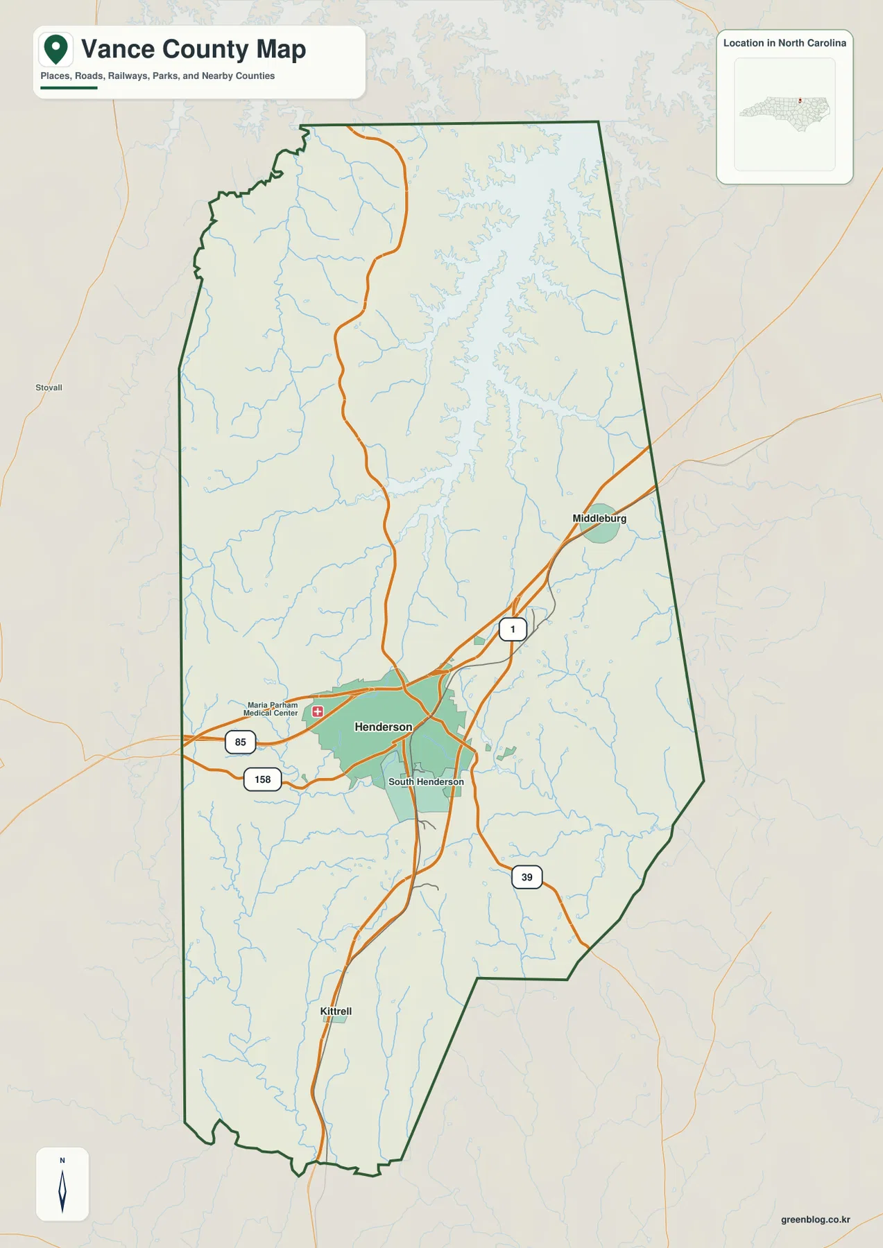
Kittrell marks a different outer direction. It lies south of Henderson in a rural section where narrow creeks and longer road stretches are more prominent than broad reservoir water. Keeping Kittrell separate from Middleburg immediately clarifies the difference between the southern rural interior and the northeastern lake side.
Places outside the county, including Stovall on the surrounding map, are only regional references. Because the boundary bends around water and outer rural areas, readers should use the dark Vance County outline together with Henderson, Middleburg, and Kittrell before assuming that every nearby place label falls inside the county.
Two river basins in a compact county
John H. Kerr Reservoir dominates the northeastern part of the terrain-and-water map. Buggs Island Lake is also labeled above the county, providing another regional name for the large reservoir system. Long narrow arms of water reach into former stream valleys, which explains why the northeastern edge looks much more intricate than the road map alone suggests.
Little Island Creek runs through the northwestern interior, while Flat Creek provides another smaller western drainage reference. These channels are useful because they show that the county’s northern landscape is not defined only by the reservoir shoreline. Even away from the large water body, stream valleys divide the otherwise gentle Piedmont surface.
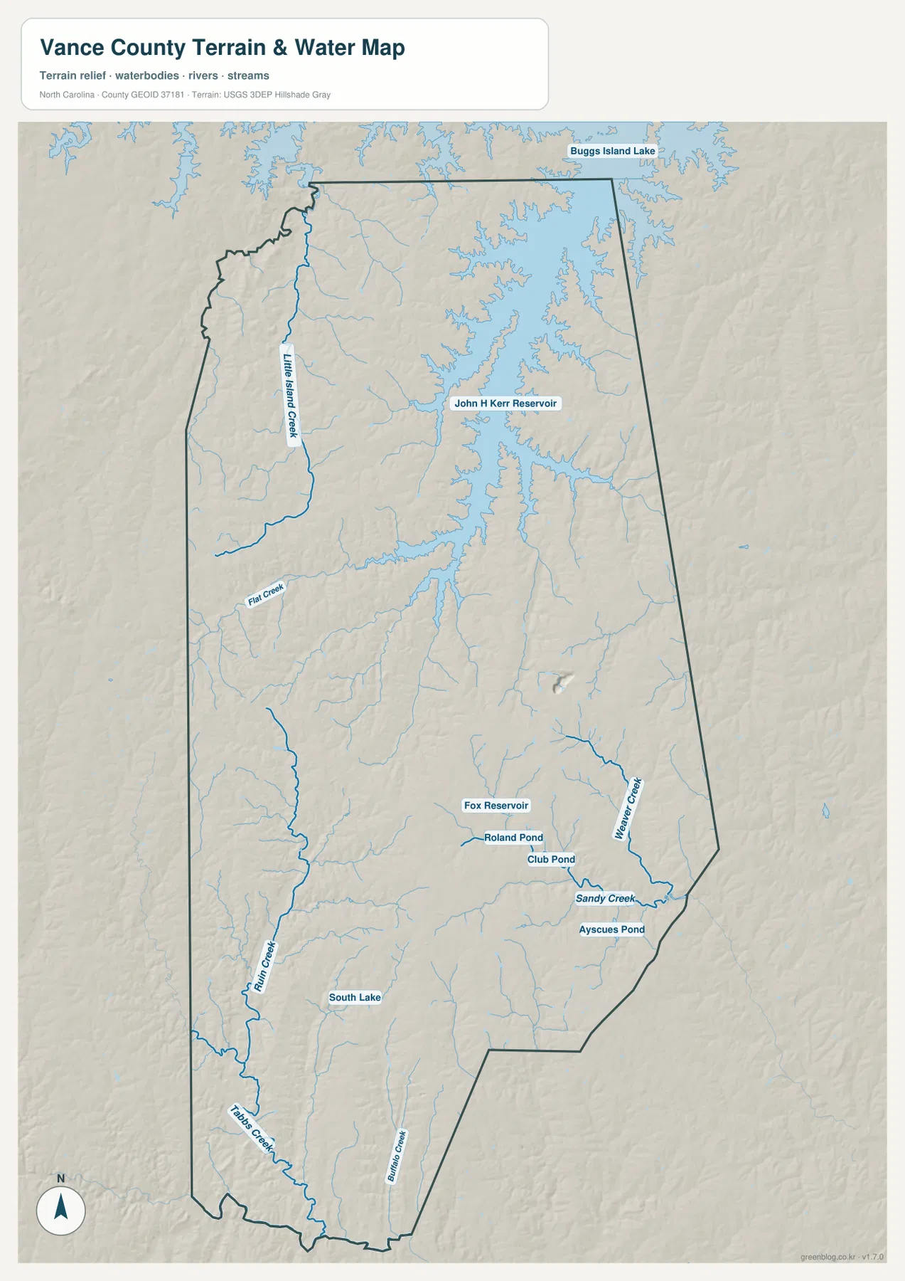
The southern half contains a different network. Ruin Creek extends through the southwest and approaches Tabbs Creek near the lower boundary, while Billie Creek marks another south-central corridor. Walker Creek and Sandy Creek provide separate southeastern references. Rather than treating these names as a checklist, it is more useful to see how the reservoir-dominated northeast contrasts with a south and west divided by smaller creek valleys.
Several small water bodies appear closer to the Henderson side. Fox Reservoir, Roland Pond, and Club Pond are grouped in the central-southern interior, South Lake appears farther southwest, and Ayscues Pond is labeled in the southeast. These are local orientation points, not water bodies comparable in scale or function to Kerr Reservoir.
North and south rural directions
The city-connections map reduces the county to three marked places and makes their relative scale obvious. Its lower panel lists Henderson at 14,885, Middleburg at 141, and Kittrell at 57. Those are values printed on this Vance County graphic, and they are not being replaced here with a separate current-population estimate.
Both outer places are shown about 7 miles from Henderson by straight-line distance. The matching number can be misleading if direction is ignored: Middleburg lies northeast toward the Kerr Reservoir side, while Kittrell lies south in a much drier-looking creek-and-road landscape. Straight-line connectors are useful for orientation, but they do not represent road mileage or travel time.
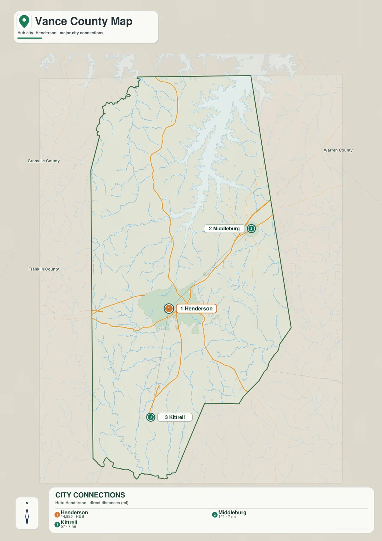
The outer labels identify Granville County, Warren County, and Franklin County. They help place Vance County within north-central North Carolina but should not be read as measurements of legal adjacency or route distance. For the internal settlement pattern, the three marked Vance County points and the county boundary remain the useful references.
Reading the city and water maps together makes the rural contrast much clearer. Northeast of Henderson, the reservoir shoreline and its feeder valleys dominate the landscape. South toward Kittrell, smaller creeks and long rural road segments become the stronger visual features. A small county can therefore contain clearly different local settings even when the main places are only a few straight-line miles apart.
Using city, lake, and basin together
A practical way to read Vance County is to start with Henderson for roads and administration, then use Middleburg for the Kerr Reservoir direction and Kittrell for the southern rural direction. Once those settlement anchors are clear, the water map shows why the outer county differs so much: the northeast is shaped by a large reservoir, while the south and west are divided by smaller creek valleys.
The general map is best when road numbers and named places matter. The city-connections view is the simplest way to compare Henderson, Middleburg, and Kittrell and to see the two 7-mile straight-line links. The terrain-and-water map is the stronger choice for the reservoir arms, Little Island Creek, Ruin Creek, Walker Creek, and the smaller ponds and reservoirs around the interior.
The download archive contains three high-resolution A3 JPG files matching the Vance County general map, city-connections map, and terrain-and-water map. The lighter WebP previews are convenient for browsing, while the JPG originals preserve more detail for printing, enlargement, and document placement, especially around the reservoir shoreline and small water labels.
For Vance County, this downloadable set is intended for broad geographic orientation rather than technical determination. Flood determinations, navigation, water depth, legal boundaries, surveying, and engineering-grade elevation work should rely on the appropriate official Census, USGS, or other authoritative source data rather than this simplified downloadable set.
Frequently Asked Questions
How does Kerr Lake connect physical geography with the named communities?
Kerr Reservoir gives the northeastern county a physical anchor that is very different from Henderson’s road-centered urban area. Reading the reservoir with Middleburg makes the lake side easier to separate from the southern Kittrell direction and from Henderson itself.
How does Kittrell improve orientation away from the county seat?
Kittrell provides a clear southern reference outside Henderson. The city map places it about 7 straight-line miles from the hub, while the water map shows a landscape of smaller creeks rather than the large reservoir shoreline seen toward Middleburg.
Map File Information
The ZIP contains three high-resolution A3 JPG files matching the Vance County general map, city-connections map, and terrain-and-water map shown on this page.
- Included Files: Use only the versions confirmed in the article and supplied images
- File Type: Use the confirmed download contents
- Intended Use: Printing, education, presentations, and map-based projects
Related Maps
- Across the Rowan County North Carolina Map
- Across the Surry County North Carolina Map
- Alamance County Map
Sources
- NCpedia – Vance County
- U.S. Census Bureau – TIGER/Line Shapefiles
- USGS – National Hydrography
- USGS – 3D Elevation Program
For this Vance County page, the linked sources cover county background together with boundary, road, hydrography, and elevation reference data. The settlement values, straight-line distances, numbered roads, reservoir names, creeks, ponds, and smaller reservoirs described above are grounded in the supplied Vance County package rather than in invented estimates.
Green Map creates custom-edited map images using open geographic data sources such as geoBoundaries, Natural Earth, OpenStreetMap, and government open data.
These maps are edited visual materials, not raw data files, and are provided for education, documents, presentations, and graphic reference.