Union County lies on the southeastern side of the Charlotte metropolitan area, but the map shows a county with more than one growth direction. Monroe is the county seat and central administrative-road hub. Indian Trail and Stallings form a dense northwestern suburban area near Mecklenburg County, while Waxhaw, Weddington, and Wesley Chapel extend another cluster toward the southwest. East of Monroe, Wingate and Marshville sit farther apart within a much more rural landscape.
The article moves from roads and settlement locations to ranked city distribution and then to the county’s rivers, creeks, lakes, and rolling Piedmont relief. WebP previews make the maps easy to inspect on the page, and the download box below provides the matching high-resolution A3 JPG files in one ZIP. The JPG files are the better choice when road numbers, creek labels, or county-wide detail need to be enlarged for print or close inspection.
Table of Contents
Union County quick facts
- County seat: Monroe
- Ranked city map: Indian Trail, Monroe, Waxhaw, Stallings, Weddington, Wesley Chapel
- Major road numbers visible on the general map include 74, 84, 75, 218, 205, 200, 207, 601, and 522
- Northwestern places include Indian Trail, Stallings, Hemby Bridge, Weddington, and Marvin
- Southwestern references include Waxhaw, Mineral Springs, and Wesley Chapel
- Eastern references include Wingate and Marshville
- Named water features include Rocky River, North Fork Crooked Creek, South Fork Crooked Creek, Waxhaw Creek, Beaverdam Creek, and Lanes Creek
The existing Union County 2050 planning material describes the long-term challenge of managing fast-growing communities alongside rural and agricultural land. The current page also gives historical background that Union County was formed in 1842 from parts of Mecklenburg and Anson counties and reaches the South Carolina side. This rewrite keeps that context brief and uses the supplied maps to explain where the growth clusters and rural sections actually appear.
Monroe versus the western suburbs
Monroe is the clearest road reference on the general map. Route 74 crosses the city and continues east through Wingate toward Marshville, while routes 84 and 75 help separate the southwest directions toward Weddington and Waxhaw. Routes 207 and 601 continue toward the southern boundary. The concentration of numbered roads explains why Monroe remains the easiest starting point even though it is not the top-ranked city on the supplied city graphic.
The northwest has a different settlement pattern. Indian Trail and Stallings sit close to the Mecklenburg County edge, with Hemby Bridge nearby and extensive developed shading around them. Compared with the eastern half of the county, town labels and developed areas are much more continuous here, making the Charlotte-facing suburban concentration easy to see.
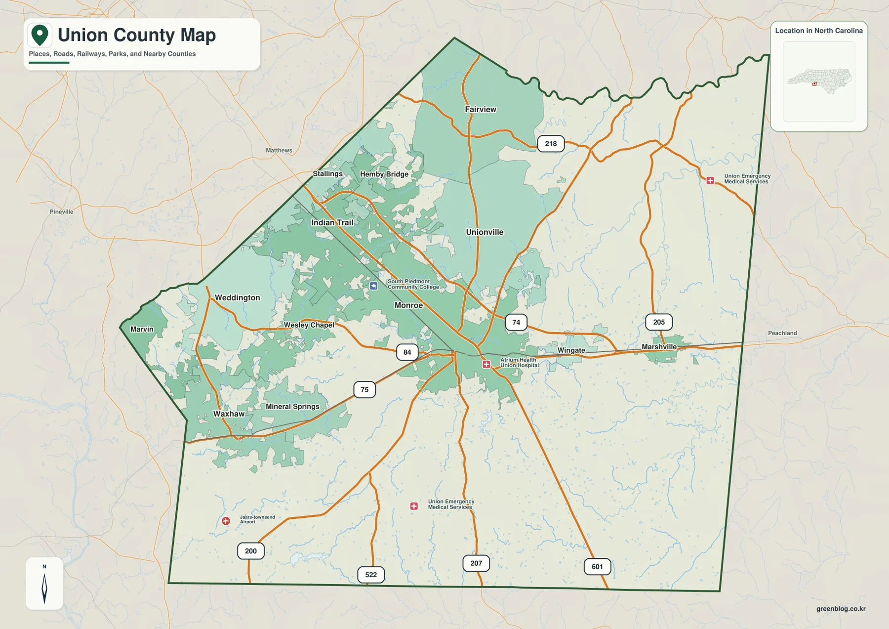
Following route 74 east from Monroe leads first to Wingate and then to Marshville. Route 205 provides another north-south reference near Marshville, but the broad developed footprint of the northwest does not continue across this side of the county. Larger spaces between named places give the eastern half a clearly more rural appearance.
The north also changes outside the suburban edge. Fairview and Unionville provide smaller references around route 218, and the Rocky River side carries a denser network of small streams. This contrast makes Union County easier to understand as a fast-growing western side plus a lower-density north, east, and southeast rather than as one continuous Charlotte suburb.
Indian Trail and Waxhaw face different corridors
The ranked city map makes the western concentration even clearer. Indian Trail is first at 42,036, Monroe second at 36,759, and Waxhaw third at 22,275. Stallings follows at 16,886, Weddington at 13,805, and Wesley Chapel at 9,090. These are values printed on the supplied city graphic; they are not presented here as independently updated population estimates.
Location matters more than rank alone. Indian Trail and Stallings sit together near the northwestern boundary, while Weddington and Wesley Chapel extend the developed area farther south. Waxhaw is separated near the southwestern edge and faces a different corridor toward the South Carolina side. Treating Waxhaw as a simple continuation of Indian Trail would hide the two distinct suburban-growth directions visible on the map.
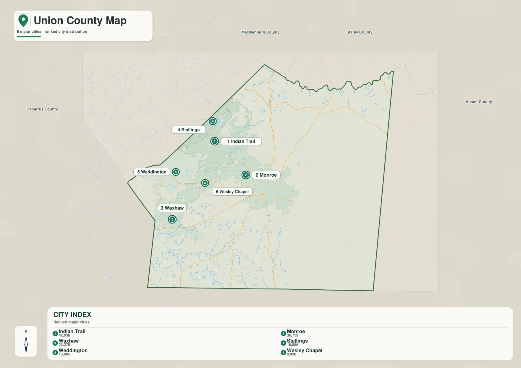
Marvin and Mineral Springs add useful southwest references even though they are not part of the six-place ranking. Together with Waxhaw, Weddington, and Wesley Chapel, they show that the western side is not a single strip running from Monroe toward Charlotte. Instead, the map contains a northwestern Indian Trail-Stallings concentration and a southwestern Waxhaw-Weddington concentration.
That geography helps explain why the Union County 2050 plan discusses growth areas and rural land together. Settlement labels, road density, and developed shading are concentrated in the western half, while the east and southeast contain much larger gaps between towns. The map does not show planning categories directly, but it gives a clear visual basis for understanding why growth management and rural preservation appear in the county’s planning discussion.
2026 rural preservation sharpens the contrast
The existing page states that a 2026 rural land-use effort emphasizes agricultural preservation and lower-impact development. Those planning areas are not drawn as boundaries on the supplied preview maps, so this article uses the statement only as background. It does not label individual parcels, farms, or districts as preserved land.
What can be seen directly is a sharp settlement-density difference. West and northwest of Monroe, Indian Trail, Stallings, Weddington, and Wesley Chapel sit relatively close together. East of Monroe, Wingate and Marshville are separated by much larger rural spaces, and the long southern road corridors contain few comparable urban areas.
The terrain-and-water map adds another layer to that contrast. Small tributaries cross the rural eastern and southern sections even where settlement labels are sparse. Low development density therefore does not mean geographic emptiness; creeks, farm roads, low ridges, and small drainage valleys divide the landscape in ways that are not obvious on the city graphic.
Comparing growth areas with rural land
Rocky River is the strongest large-water reference near the northern edge of the terrain map. North Fork Crooked Creek and South Fork Crooked Creek occupy separate northwestern valleys, while Lake Twitty and Plyler Lake provide local references north and northeast of Monroe. The same part of the county that looks heavily developed on the general map still contains a dense network of streams and small reservoirs.
Closer to Monroe, Lake Lee and Lake Monroe are labeled within the interior. Rays Fork and Beaverdam Creek continue toward the east, while Waxhaw Creek provides a strong southwestern water reference. Lanes Creek appears farther south. These waterways cross the county independently of the urban road corridors, so the physical landscape cannot be reduced to the same west-to-east growth pattern shown by the towns.
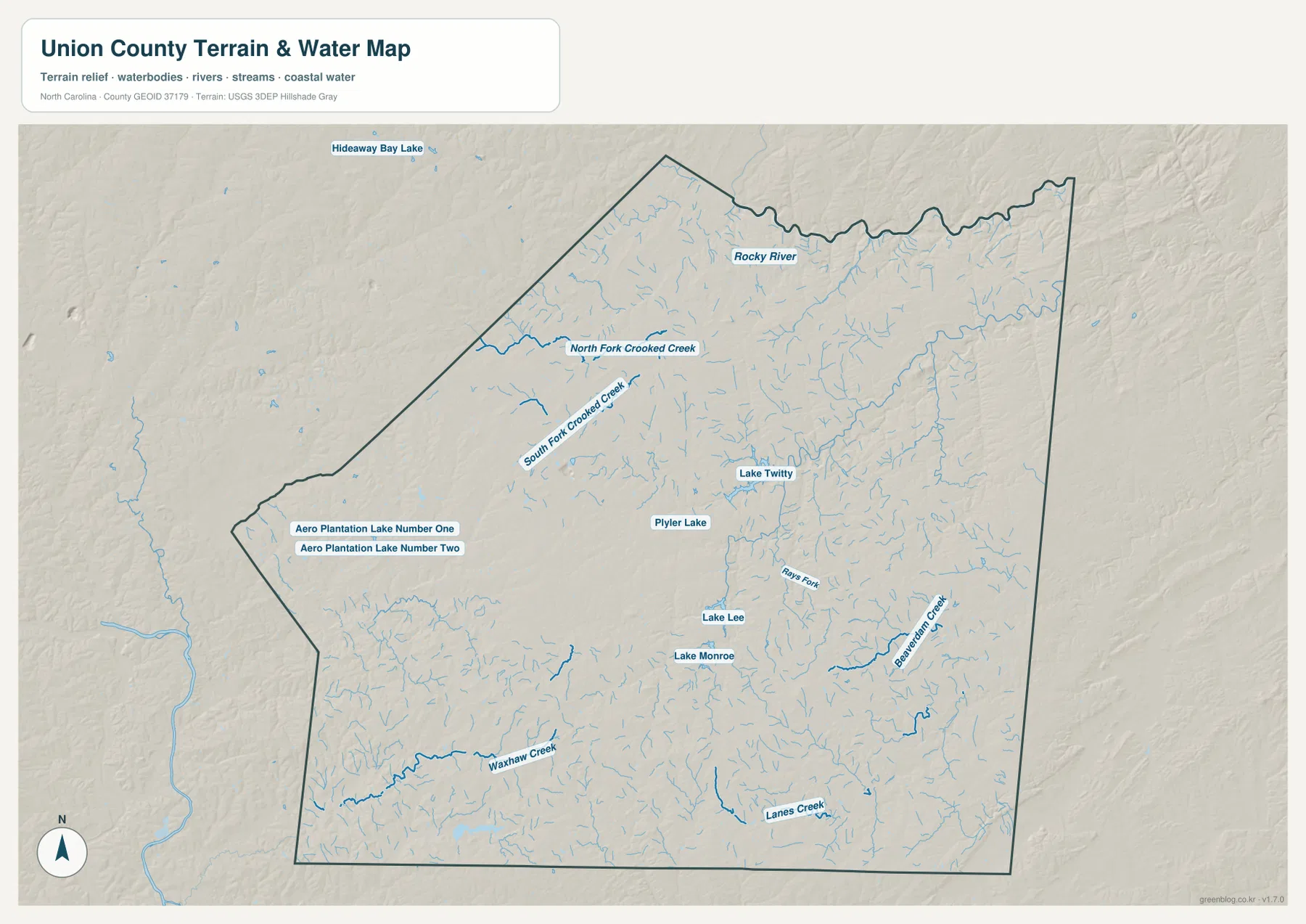
Relief is gentler than in western North Carolina, but the terrain is not completely flat. Low Piedmont ridges and stream valleys repeat across the county, including the less-developed east and south. The terrain-and-water image is intended for general geographic orientation and should not be treated as a flood-hazard map, parcel survey, water-depth chart, or engineering-grade elevation product.
A useful reading order is to start with Monroe, then separate the Indian Trail-Stallings northwest from the Waxhaw-Weddington southwest and the Wingate-Marshville east. Adding Rocky River, Crooked Creek, and Waxhaw Creek shows how those settlement zones sit on a shared natural landscape rather than on blank land. This makes the growth-versus-rural contrast clearer without turning the page into a planning-zoning map.
The download archive contains three high-resolution A3 JPG files matching the Union County general map, city-distribution map, and terrain-and-water map. For close inspection or print work, use the JPG originals rather than the lighter WebP previews. Legal boundaries, surveying, flood determinations, and official planning-area decisions should rely on the appropriate Census, USGS, or Union County source data.
Frequently Asked Questions
What do Rocky River and Crooked Creek add to the northern Union County map?
Rocky River provides the broad northern reference, while the north and south forks of Crooked Creek divide smaller valleys in the northwest. Reading those waterways beside Indian Trail and Stallings shows that the suburban area still contains a dense stream-and-reservoir landscape.
Why is Indian Trail worth separating from Monroe?
Monroe is the county’s central administrative and road hub, while Indian Trail sits near the Mecklenburg County boundary within the northwestern suburban concentration. Keeping the two places separate makes the difference between county-center functions and Charlotte-facing suburban growth much easier to see.
Map File Information
The ZIP contains three high-resolution A3 JPG files matching the Union County general map, city-distribution map, and terrain-and-water map shown on this page.
- Included Files: Use only the versions confirmed in the article and supplied images
- File Type: Use the confirmed download contents
- Intended Use: Printing, education, presentations, and map-based projects
Related Maps
- Across the Rowan County North Carolina Map
- Across the Surry County North Carolina Map
- Alamance County Map
Sources
- Union County 2050 Comprehensive Plan
- U.S. Census Bureau – TIGER/Line Shapefiles
- USGS – National Hydrography
- USGS – 3D Elevation Program
The county planning source provides the growth-and-rural background used here, while Census and USGS links support boundary, road, hydrography, and elevation-source checks. The city rankings, road numbers, lakes, Rocky River, Crooked Creek, Waxhaw Creek, and other named water features described above come from the supplied Union County map package rather than from invented estimates or planning overlays.
Green Map creates custom-edited map images using open geographic data sources such as geoBoundaries, Natural Earth, OpenStreetMap, and government open data.
These maps are edited visual materials, not raw data files, and are provided for education, documents, presentations, and graphic reference.