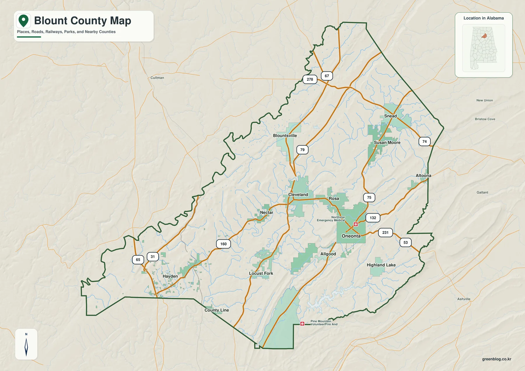
Blount County sits in north-central Alabama, where Oneonta, smaller communities, wooded ridges, valleys, and branching waterways shape the county. You can download the complete Blount County map set from this page as one ZIP with four high-resolution A3 landscape JPG files. The on-page maps are WebP previews, while the downloadable files provide larger versions of the county boundary and roads, community locations, waterways such as Locust Fork, and county-wide elevation for printing, classroom use, presentations, or personal map projects.
If the county is unfamiliar, Oneonta is the simplest place to begin. From there, the maps make it easier to place Blountsville, Susan Moore, Snead, Locust Fork, and Hayden in relation to the county center, then compare those locations with streams, lakes, ridges, and lower valleys. Each map focuses on a different part of the same geography, so you can use only the sheet you need or compare them side by side when a road, town, water feature, and elevation all matter.
Table of Contents
Start with Oneonta and the Main County Roads
Oneonta works well as an orientation point because it is the county seat and lies near the middle of the mapped area. Once you locate it, the rest of Blount County becomes easier to organize: Blountsville and Susan Moore are farther north, Snead is toward the northeast, and Locust Fork and Hayden are to the southwest. Looking at these places together with the county outline gives a much clearer sense of distance and direction than reading the town names by themselves.
The general county map is the best first sheet when you need boundaries and roads on the same page. It helps with route planning at a broad scale, locating a town before checking another map, or simply understanding how the county is shaped within this part of Alabama. It is also useful as a reference layer when you move to the water and elevation maps, because the same places can be compared across the set.
Compare the Locations of Blount County Communities
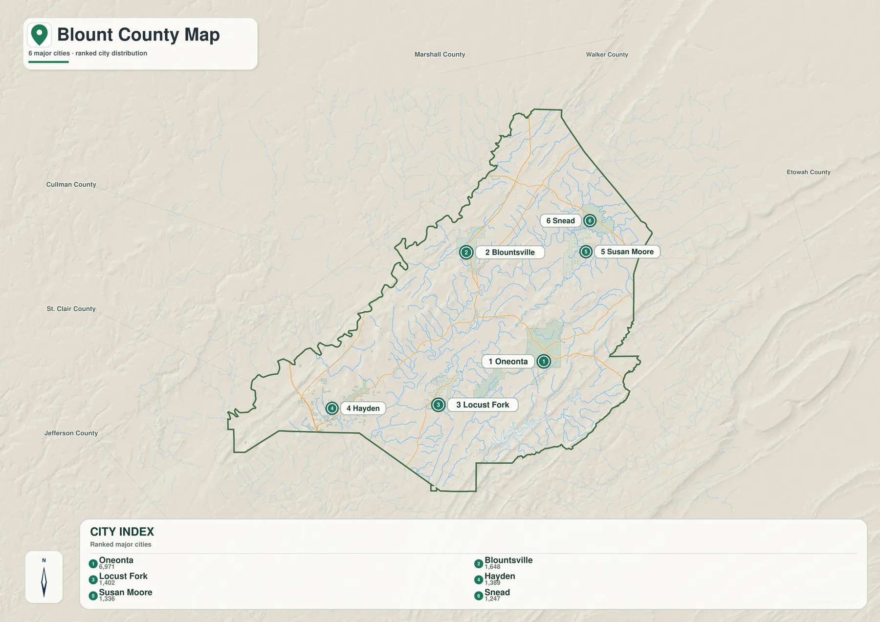
Blount County’s highlighted municipalities are spread across several parts of the county rather than concentrated in a single cluster. Oneonta is the most convenient central reference, while Blountsville and Susan Moore help define the northern part of the county. Snead sits farther to the northeast, and Locust Fork and Hayden provide useful reference points toward the southwest. Seeing these names on one dedicated city sheet makes it easier to understand the county before adding the extra detail of streams or terrain.
This map is especially helpful for readers who want to compare communities without the visual weight of every other geographic feature. It can support school projects, local presentations, trip planning, or any task where the relative position of towns matters more than detailed hydrology. When a location is difficult to place from the name alone, checking the city sheet first often makes the other maps faster to use.
Follow Locust Fork and Nearby Water Features
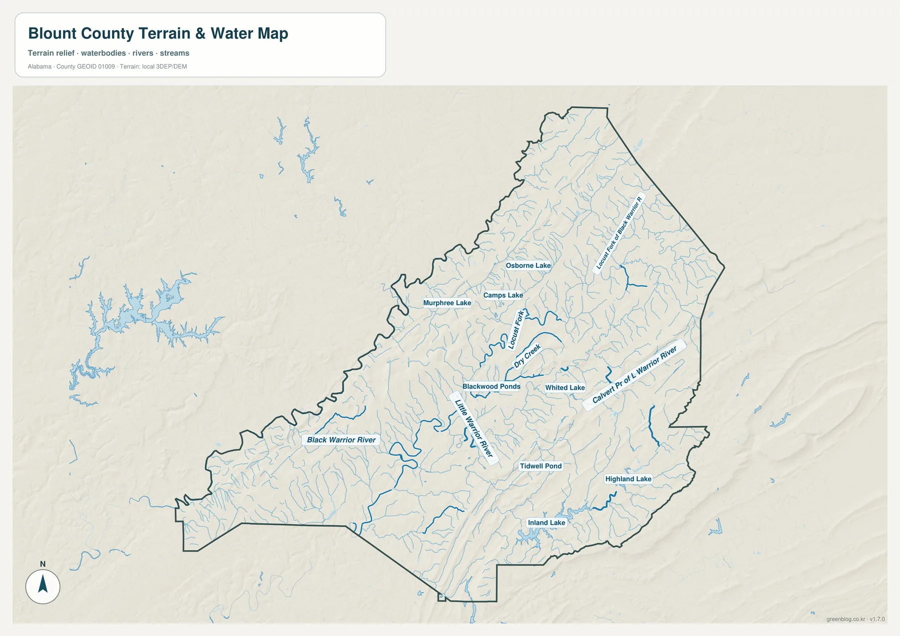
Locust Fork is one of the easiest water features to use as a geographic reference in Blount County. Following its course and the smaller tributaries around it provides a different view of the county than roads alone. The map also identifies the Black Warrior River toward the west, the Little Warrior River to the south, and the Calvert Prong of Warrior River toward the east, allowing the reader to compare water features on several sides of the county without reducing the section to a list of names.
Lakes and ponds can be even more useful when you are trying to narrow down a specific area. Murphree Lake, Camps Lake, Osborne Lake, Blackwood Ponds, Whited Lake, Inland Lake, and Highland Lake appear as smaller landmarks that can be checked against nearby towns and roads. The most practical approach is to begin with the community or road you already know and then look for the nearest named water feature. That makes the water map useful for orientation as well as for a general view of the county’s drainage network.
See the Ridge-and-Valley Relief More Clearly
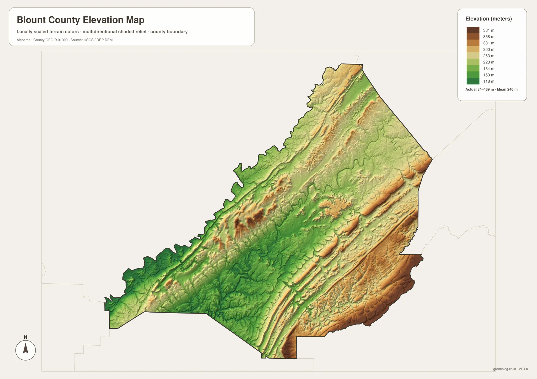
Elevation adds an important part of the picture because Blount County is not uniformly flat. The elevation sheet shows long higher ridges separated by lower valleys, with the mapped range extending from roughly 84 meters to 469 meters. Those differences make the alternating bands of higher and lower ground visible at a glance and help explain why the landscape looks different from one part of the county to another.
Comparing the elevation map with the road and water sheets is often more useful than reading it by itself. Streams tend to occupy lower ground, while higher ridges stand out between them, so the relationship between terrain and drainage becomes easier to see. The map is intended for general geographic reference and education rather than engineering, construction, property boundary work, or survey-grade measurement. Projects requiring precise elevations should rely on authoritative survey and elevation data.
Choose the Map That Fits the Task
For a quick county overview, begin with the general map because it combines the boundary with roads and place names. Switch to the city sheet when the goal is to compare communities, and use the water sheet when a stream, river, lake, or pond is the most useful landmark. The elevation map adds terrain, making it helpful when you want to see whether a place lies near higher ridge country or in a lower valley.
The same set can serve different kinds of readers. A teacher may want the county and city sheets for a local geography lesson, while a presentation about natural features may benefit more from the water and elevation maps. Someone preparing a printed reference can keep all four JPG files together and choose the most relevant one for each page. Because the downloadable versions are larger than the on-page previews, they are the better choice when labels need to remain readable on paper.
These maps are also useful when one feature is not enough to identify a place. A town can first be located on the city map, checked against nearby roads on the general map, matched with a creek or lake on the water map, and then compared with the surrounding terrain. That kind of cross-check is often more intuitive than trying to extract every detail from a single crowded sheet.
Frequently Asked Questions
Why is Oneonta a good place to begin when reading these maps?
Oneonta is the county seat and provides a convenient central reference for comparing roads and nearby communities. After locating Oneonta, it is much easier to place the northern and southwestern parts of the county on the other maps.
How can I use Locust Fork to orient myself on the water map?
Find Locust Fork first, then compare its course with nearby tributaries, towns, roads, lakes, and ponds. Using one familiar water feature as an anchor is simpler than trying to identify every stream at once.
Is the elevation sheet accurate enough for engineering work?
No. It is designed to show broad differences between higher ridges and lower valleys across the county. Surveying, engineering, construction, and legal boundary work require appropriate professional or official data sources.
What is included in the downloadable Blount County map set?
The ZIP contains four A3 landscape JPG files: a general county map, a city map, a water map, and an elevation map. The WebP images in the article are page previews, while the JPG files in the archive are the higher-resolution versions for download and printing.
Map File Information
Download the full-resolution Blount County map set in one ZIP archive.
- Included Files: County, city, water, and elevation maps
- File Type: Four high-resolution A3 landscape JPG files
- Intended Use: Printing, education, presentations, and map-based projects
Related Maps
Blount County Sources and Reference Links
The following sources provide additional information about boundaries, roads, waterways, elevation, statistics, and local background. The maps on this page are designed as accessible geographic references and do not replace current official records or professional survey data.
- U.S. Census Bureau TIGER/Line — county and place boundaries
- Alabama Department of Transportation — state road maps
- USGS National Hydrography — rivers and streams
- USGS 3D Elevation Program — elevation data
- U.S. Census Bureau QuickFacts — Blount County statistics
- Encyclopedia of Alabama — county background and local history
- Alabama Population Density Map: Urban Clusters, County Totals and a Decade of Change
Green Map creates custom-edited map images using open geographic data sources such as geoBoundaries, Natural Earth, OpenStreetMap, and government open data. These maps are edited visual materials, not raw data files, and are provided for education, documents, presentations, and graphic reference.