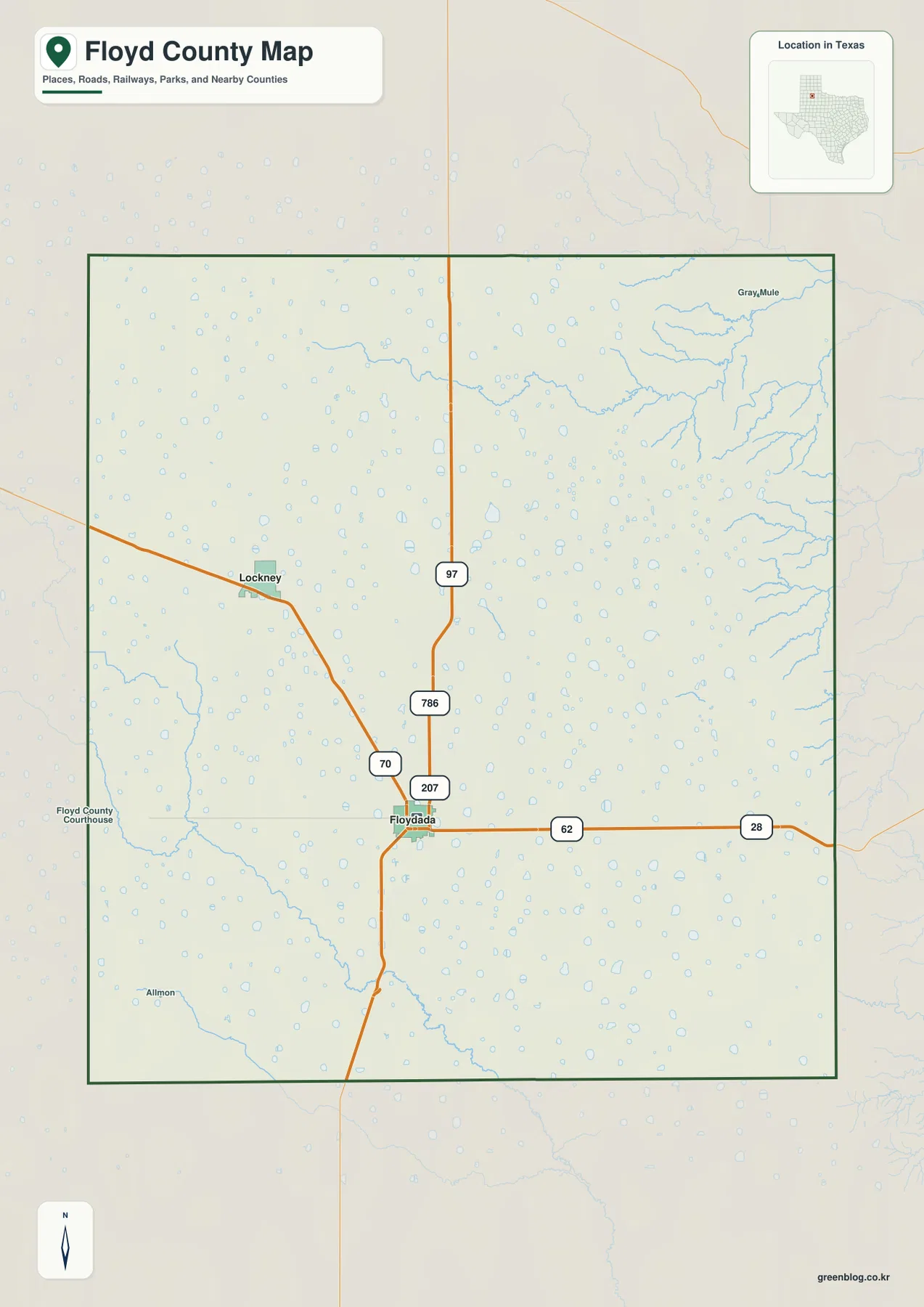
Floyd County, Texas changes character sharply from west to east. Floydada and Lockney sit on a broad, high plain crossed by long, mostly direct roads, while the eastern edge is cut by a dense set of creek valleys and lower canyon country. The maps on this page show that contrast through roads and settlements, a two-city distribution view, named waterways, and a locally scaled elevation surface. High-resolution A3 JPG versions of all supplied maps are available in the ZIP download box below.
Floydada is the easiest place to use as an orientation point. It lies south of the county’s center and is surrounded by several numbered roads, with the Floyd County Courthouse marked nearby. Lockney is northwest of Floydada on the flatter part of the county. From either city, the landscape looks relatively open until the map reaches the east, where tributaries multiply and the elevation surface breaks into narrow, lower valleys.
Table of Contents
Roads Converging at Floydada
The county map places Floydada at the junction of several prominent routes. Road 62 runs east and west through the city, while 70 and 207 form important north-south connections. Farther north, 97 and 786 continue across the open plain. Lockney appears northwest of Floydada, reached through a simpler road pattern than the cluster of routes around the county’s main central settlement.
These road lines are strikingly straight across the western and central parts of Floyd County. East of Floydada, 62 continues toward the county edge while the natural surface below it becomes increasingly broken by drainage channels. That creates one of the clearest visual contrasts on the map: transportation remains comparatively direct across the plain even as the eastern terrain becomes much more irregular.
The general map also marks the Floyd County Courthouse and smaller local labels such as Allmon. They help establish scale between the two highlighted cities and the much larger stretches of lightly labeled land. Some neighboring-county labels around the outside of the city preview do not align reliably with real compass directions, so this article uses the internal county roads, places, waterways, and terrain rather than those outer labels for geographic description.
A Two-City Pattern: Floydada and Lockney
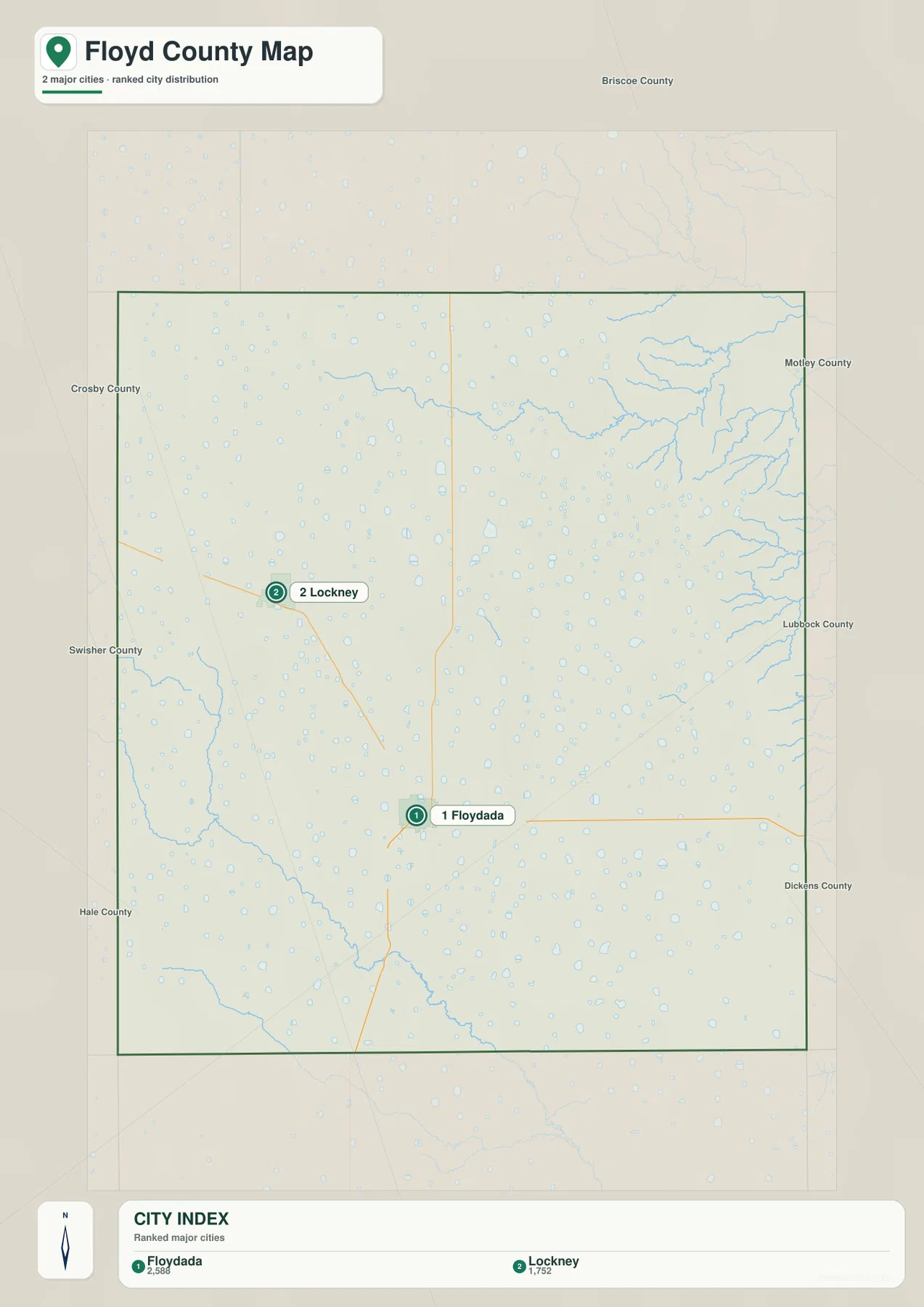
The city map highlights only two major cities. Floydada is ranked first and Lockney second, making the settlement pattern unusually simple to read compared with counties that have several similar-sized centers. Floydada sits a little south of the county’s middle, while Lockney is clearly northwest. The graphic does not show connector-mile labels between them, so its value is in direction, spacing, and relative city ranking rather than a precise distance measurement.
Floydada has the denser road junction, whereas Lockney sits in a quieter-looking part of the northwest plain. Large spaces separate the two highlighted communities from the eastern canyon country. This arrangement makes the city map useful for seeing how concentrated the labeled settlement is: the county is not filled with a continuous chain of towns, and the broad spaces between Floydada, Lockney, and the eastern edge are an important part of the picture.
For route planning, use the city view to establish where the two communities lie and then return to the county map for the road numbers. That sequence keeps the city comparison simple without treating the city-index graphic as a detailed navigation map.
Eastern Creek Valleys and the White River
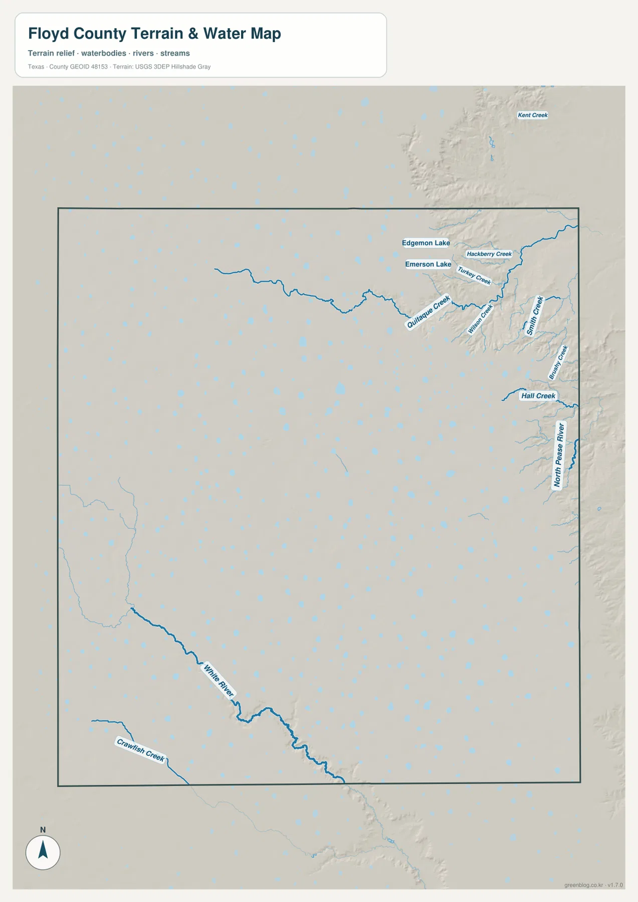
The water map is busiest along the eastern side of the county. Hackberry Creek and Turkey Creek appear in the northeast, with Wilson Creek and Smith Creek extending through the dissected terrain farther south. Hall Creek is labeled near the eastern edge, and North Pease River forms a long, prominent watercourse in the same general area. These channels occupy the part of Floyd County where the shaded relief becomes steepest and most deeply cut.
A different drainage feature stands out in the southwest. White River runs through a long valley across the lower-left portion of the county map, while Crawfish Creek appears near the southwest edge. In the northeast, Edgemon Lake and Emerson Lake sit close to the creek network. The supplied map therefore shows more than one drainage focus: numerous short and branching eastern creeks contrast with the stronger White River valley on the opposite side.
This water reference is meant for locating rivers, creeks, and lakes relative to the county boundary and terrain. It does not indicate flood zones, legal shoreline limits, stream permanence, water depth, or navigability. For ordinary map reading, its main value is showing where the flat-looking county map gives way to valleys that are easy to miss without the terrain layer.
From High Plains to Lower Eastern Valleys
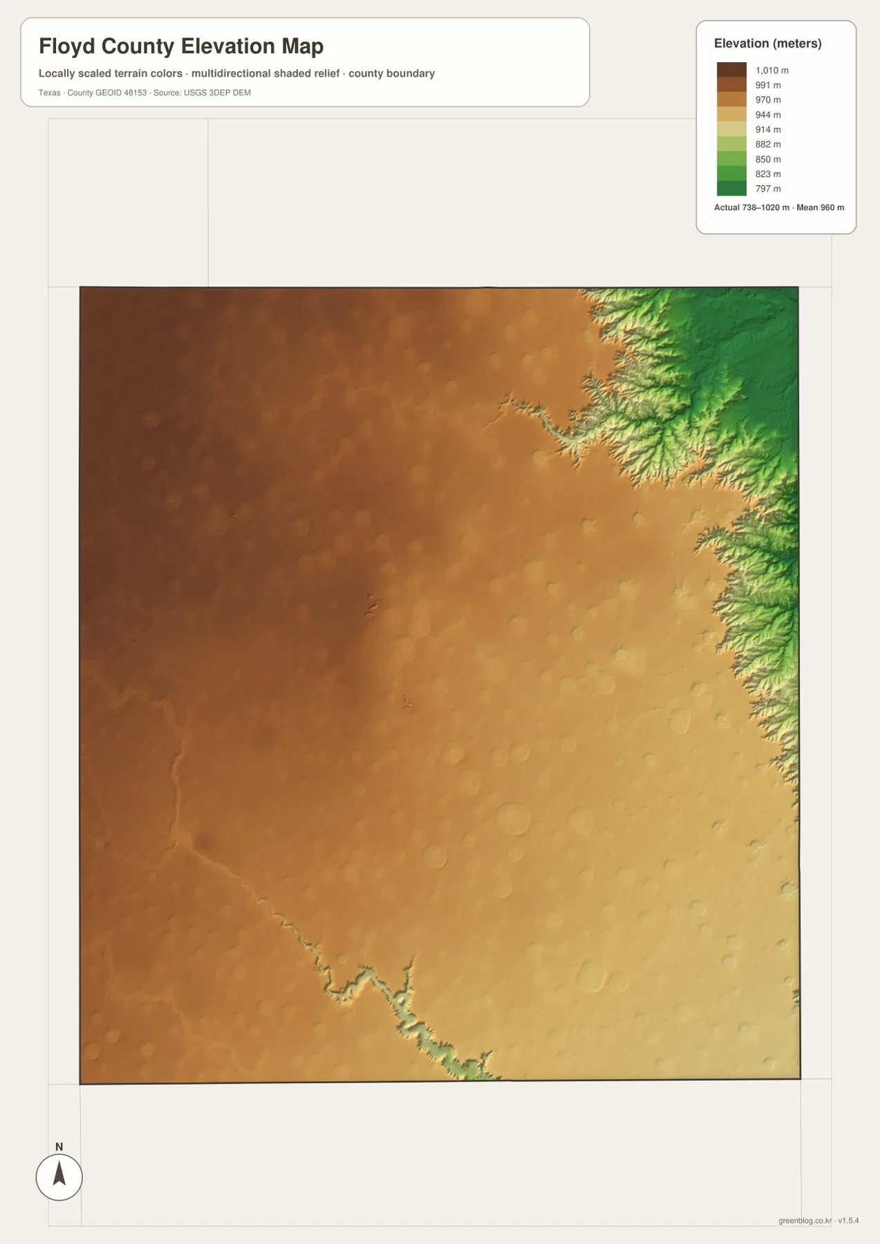
The elevation map gives Floyd County an actual mapped range of about 738 to 1,020 meters, with a mean near 960 meters. Brown shades dominate the west and northwest, where the surface remains high and broad. Moving eastward, the colors shift through tan and yellow toward green, and the eastern margin becomes sharply incised by lower valleys. The change is especially dramatic in the northeast, where narrow tributary cuts reach back into the higher plain.
The water map explains much of that color pattern. Lower green channels line up with the creek system around Hackberry Creek, Turkey Creek, Smith Creek, Hall Creek, and North Pease River. A separate low corridor follows White River in the southwest. Floydada and Lockney, by comparison, sit on the smoother and generally higher interior plain rather than within the deepest drainage cuts.
The elevation colors are generalized for county-scale comparison. They are useful for understanding where relief increases and where valleys cut into the plateau, but they are not survey-grade measurements for a parcel, a road grade, or an engineering project. The map’s strength is the broad transition from high western tableland to the lower, much more rugged eastern edge.
What Changes When You Move East from Floydada
Floydada provides a useful center for comparing both sides of the county. To the northwest, the route toward Lockney crosses broad terrain with relatively little relief visible at this scale. East of Floydada, Road 62 continues across the plain but the land beneath it begins to break into more channels and valleys. The elevation map reinforces that transition by changing from higher brown and tan surfaces to greener, lower ground near the eastern boundary.
The change is not confined to one river valley. Several eastern creeks carve parallel and branching cuts, while North Pease River occupies a larger low corridor. White River creates another valley in the southwest, showing that the county’s relief is not simply a one-direction slope. Floyd County is best understood as a high plain with deeply cut margins and drainage corridors rather than as an entirely uniform tabletop.
Matching the Map to the Question
Use the county map when you need Floydada, Lockney, numbered roads, the courthouse, and the county boundary together. The city map is better for a quick comparison of the two highlighted settlements. For North Pease River, White River, the eastern creeks, or the small northeastern lakes, move to the water map. The elevation view is the clearest choice when the question is why the eastern edge looks so different from the broad plain around Floydada and Lockney.
The WebP images on the page are convenient for viewing, while the downloadable files are designed for larger output and offline use. The ZIP contains high-resolution A3 JPG copies of the county, city, water, and elevation maps, so you can print the map that best fits a classroom project, local reference task, presentation, or personal archive.
Frequently Asked Questions
Where are Floydada and Lockney within Floyd County?
Floydada is in the south-central part of the county, while Lockney is northwest of it. The city map ranks Floydada first and Lockney second and shows a broad gap of open terrain between and around the two highlighted communities.
Why does the eastern side of Floyd County look so rugged?
North Pease River and several creeks cut deeply into the eastern margin of the high plain. On the elevation map, those valleys appear much lower than the smoother western and central surfaces, which creates the strong visual change along the east side.
What elevation range is shown on the supplied map?
The elevation map lists an actual range of about 738 to 1,020 meters and a mean near 960 meters. The higher broad surface is concentrated toward the west and northwest, while lower terrain follows the eastern creek valleys and the White River corridor.
Sources and Reference Data
USGS The National Map Viewer — Official U.S. Geological Survey map service for terrain, roads, hydrography, and other geographic layers.
USGS National Hydrography — Official reference for rivers, streams, lakes, and hydrographic data.
USGS 3D Elevation Program — U.S. Geological Survey elevation and terrain data program.
U.S. Census Bureau TIGER/Line Shapefiles — Official source for county boundaries, roads, and related base geography.
Map File Information
Download the Floyd County county map, city map, water map, and elevation map as high-resolution A3 JPG files. The ZIP contains the original map files shown on this page.
- File Type: JPG
Related Maps
- Motley County Texas map
- Swisher County Texas map
- Armstrong County Texas map
- Scurry County Texas map
- Stonewall County Texas map
Green Map creates custom-edited map images using open geographic data sources such as geoBoundaries, Natural Earth, OpenStreetMap, and government open data.
These maps are edited visual materials, not raw data files, and are provided for education, documents, presentations, and graphic reference.